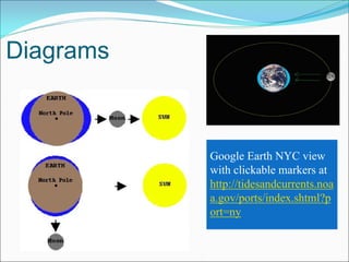
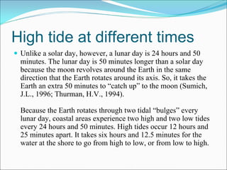
New York Harbor
What are Tides?
 The water in all oceans and estuaries rises to a high level
 approximately every 12 hours, and to a low level 6 hours
 earlier and later.
 An estuary is where salt and fresh water mix, in harbors
 and rivers near where they meet the ocean. The Hudson
 River is part of an estuary that extends 50 miles north of
 NYC. The entire estuary feels the up and down effect of
 tides.
 http://oceanservice.noaa.gov/
What causes Tides
 Gravity is one major force that creates tides. In 1687, Sir Isaac
 Newton explained that ocean tides result from the gravitational
 attraction of the sun and moon on the oceans of the earth
 http://oceanservice.noaa.gov/education/kits/tides/tides02_cause.html

 Tides are the rise and fall of sea levels caused by the combined
 effects of the rotation of the Earth and the gravitational forces
 exerted by the Moon and the Sun. The tides occur with a period
 of approximately 12 and a half hours. Most coastal areas
 experience two daily high (and two low) tides.
 http://en.wikipedia.org/wiki/Tide
Today’s Tides - 11/11/2009
 At the Battery, NYC:
 High Tide              3:12 am        3:26 pm
 Low Tide               9:34 am       10:06 pm
 Tomorrow’s Low        10:32 am       10:55 pm

 Source: Eldridge 2009 Tide and Pilot Book, p 127.
Diagrams


           Google Earth NYC view
           with clickable markers at
           http://tidesandcurrents.noa
           a.gov/ports/index.shtml?p
           ort=ny
High tide at different times
 Unlike a solar day, however, a lunar day is 24 hours and 50
 minutes. The lunar day is 50 minutes longer than a solar day
 because the moon revolves around the Earth in the same
 direction that the Earth rotates around its axis. So, it takes the
 Earth an extra 50 minutes to “catch up” to the moon (Sumich,
 J.L., 1996; Thurman, H.V., 1994).

 Because the Earth rotates through two tidal “bulges” every
 lunar day, coastal areas experience two high and two low tides
 every 24 hours and 50 minutes. High tides occur 12 hours and
 25 minutes apart. It takes six hours and 12.5 minutes for the
 water at the shore to go from high to low, or from low to high.
More about Tides
 In New York Harbor, the difference between high and low
 tide is about 5½ feet.
 Closer to the Equator, the difference between high and low
 tide is less – as small as two feet.
 Closer to the North and South poles, the difference
 between high and low tide is greatest, as much as 35-feet
 of difference every 12 hours!
More about Tides


        Photo credits: Bay of Fundy, Canada, http://en.wikipedia.org/wiki/Tide
                       Haines, Alaska, photo by MN Hawk
New York Harbor Tides
 Times of High and Low Water / NOAA Tides at
 http://tidesandcurrents.noaa.gov/tides09/tpred2.html#NY
What are Currents?
 Oceanic currents are driven by several factors. One is the rise
 and fall of the tides, which is driven by the gravitational
 attraction of the sun and moon on Earth's oceans. Tides create a
 current in the oceans, near the shore, and in bays and estuaries
 along the coast. These are called "tidal currents." Tidal currents
 are the only type of currents that change in a very regular
 pattern and can be predicted for future dates.
 A second factor that drives ocean currents is wind. Winds drive
 currents that are at or near the ocean's surface. These currents
 are generally measured in meters per second or in knots (1 knot
 = 1.15 miles per hour or 1.85 kilometers per hour). Winds drive
 currents near coastal areas on a localized scale, and in the open
 ocean on a global scale.
Currents II
 Tidal currents occur in conjunction with the rise and fall of the
 tide. The vertical motion of the tides near the shore causes the
 water to move horizontally, creating currents. When a tidal
 current moves toward the land and away from the sea, it
 “floods.” When it moves toward the sea away from the land, it
 “ebbs.” These tidal currents that ebb and flood in opposite
 directions are called “rectilinear” or “reversing” currents.

 Check out the animation at
 http://oceanservice.noaa.gov/education/kits/currents/02tidal1.html
New York Harbor Currents

 NY Harbor current charts scanned from EldridgeTide and
 Pilot Guide at
 http://www.weerow.org/content/tides+currents/

 Next 2 slides show currents at High and Low tide
High Water – Flood to Ebb
Low Water - Ebb
Conclusion

The tides' influence on current flow is much more difficult to
analyze, and data is much more difficult to collect. A tidal
height is a simple number which applies to a wide region
simultaneously. A flow has both a speed and a direction, both
of which can vary substantially with depth and over short
distances.

Animated hourly currents with stop action available at
http://tidesandcurrents.noaa.gov/ofs/nyofs/now_cg_cur.shtmlb
Thank you for
Watching this Show!
     Happy and Safe Boating on New York Harbor!

Tides And Currents

  • 1.
  • 2.
    What are Tides? The water in all oceans and estuaries rises to a high level approximately every 12 hours, and to a low level 6 hours earlier and later. An estuary is where salt and fresh water mix, in harbors and rivers near where they meet the ocean. The Hudson River is part of an estuary that extends 50 miles north of NYC. The entire estuary feels the up and down effect of tides. http://oceanservice.noaa.gov/
  • 3.
    What causes Tides Gravity is one major force that creates tides. In 1687, Sir Isaac Newton explained that ocean tides result from the gravitational attraction of the sun and moon on the oceans of the earth http://oceanservice.noaa.gov/education/kits/tides/tides02_cause.html Tides are the rise and fall of sea levels caused by the combined effects of the rotation of the Earth and the gravitational forces exerted by the Moon and the Sun. The tides occur with a period of approximately 12 and a half hours. Most coastal areas experience two daily high (and two low) tides. http://en.wikipedia.org/wiki/Tide
  • 4.
    Today’s Tides -11/11/2009 At the Battery, NYC: High Tide 3:12 am 3:26 pm Low Tide 9:34 am 10:06 pm Tomorrow’s Low 10:32 am 10:55 pm Source: Eldridge 2009 Tide and Pilot Book, p 127.
  • 5.
    Diagrams Google Earth NYC view with clickable markers at http://tidesandcurrents.noa a.gov/ports/index.shtml?p ort=ny
  • 6.
    High tide atdifferent times Unlike a solar day, however, a lunar day is 24 hours and 50 minutes. The lunar day is 50 minutes longer than a solar day because the moon revolves around the Earth in the same direction that the Earth rotates around its axis. So, it takes the Earth an extra 50 minutes to “catch up” to the moon (Sumich, J.L., 1996; Thurman, H.V., 1994). Because the Earth rotates through two tidal “bulges” every lunar day, coastal areas experience two high and two low tides every 24 hours and 50 minutes. High tides occur 12 hours and 25 minutes apart. It takes six hours and 12.5 minutes for the water at the shore to go from high to low, or from low to high.
  • 7.
    More about Tides In New York Harbor, the difference between high and low tide is about 5½ feet. Closer to the Equator, the difference between high and low tide is less – as small as two feet. Closer to the North and South poles, the difference between high and low tide is greatest, as much as 35-feet of difference every 12 hours!
  • 8.
    More about Tides Photo credits: Bay of Fundy, Canada, http://en.wikipedia.org/wiki/Tide Haines, Alaska, photo by MN Hawk
  • 9.
    New York HarborTides Times of High and Low Water / NOAA Tides at http://tidesandcurrents.noaa.gov/tides09/tpred2.html#NY
  • 10.
    What are Currents? Oceanic currents are driven by several factors. One is the rise and fall of the tides, which is driven by the gravitational attraction of the sun and moon on Earth's oceans. Tides create a current in the oceans, near the shore, and in bays and estuaries along the coast. These are called "tidal currents." Tidal currents are the only type of currents that change in a very regular pattern and can be predicted for future dates. A second factor that drives ocean currents is wind. Winds drive currents that are at or near the ocean's surface. These currents are generally measured in meters per second or in knots (1 knot = 1.15 miles per hour or 1.85 kilometers per hour). Winds drive currents near coastal areas on a localized scale, and in the open ocean on a global scale.
  • 11.
    Currents II Tidalcurrents occur in conjunction with the rise and fall of the tide. The vertical motion of the tides near the shore causes the water to move horizontally, creating currents. When a tidal current moves toward the land and away from the sea, it “floods.” When it moves toward the sea away from the land, it “ebbs.” These tidal currents that ebb and flood in opposite directions are called “rectilinear” or “reversing” currents. Check out the animation at http://oceanservice.noaa.gov/education/kits/currents/02tidal1.html
  • 12.
    New York HarborCurrents NY Harbor current charts scanned from EldridgeTide and Pilot Guide at http://www.weerow.org/content/tides+currents/ Next 2 slides show currents at High and Low tide
  • 13.
    High Water –Flood to Ebb
  • 14.
  • 15.
    Conclusion The tides' influenceon current flow is much more difficult to analyze, and data is much more difficult to collect. A tidal height is a simple number which applies to a wide region simultaneously. A flow has both a speed and a direction, both of which can vary substantially with depth and over short distances. Animated hourly currents with stop action available at http://tidesandcurrents.noaa.gov/ofs/nyofs/now_cg_cur.shtmlb
  • 16.
    Thank you for Watchingthis Show! Happy and Safe Boating on New York Harbor!