
Recommended
More Related Content
What's hot
What's hot (20)
Similar to Measuring Earth's Shape & Size
Similar to Measuring Earth's Shape & Size (20)
More from Md. Yousuf Gazi
More from Md. Yousuf Gazi (20)
Recently uploaded
Recently uploaded (20)
Measuring Earth's Shape & Size
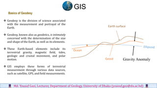
- 1. ❖ Geodesy is the division of science associated with the measurement and portrayal of the Earth. ❖ Geodesy, known also as geodetics, is intimately concerned with the determination of the size and shape of the Earth, as well as its elements. ❖ These Earth-based elements include its terrestrial gravity, magnetic field, tides, geologic and crustal movement, and polar motion. ❖ GIS employs these forms of terrestrial measurement through various data sources, such as satellite, GPS, and field measurements. Ocean Geoid Earth surface Gravity Anomaly Basics of Geodesy GIS Md. Yousuf Gazi, Lecturer, Department of Geology, University of Dhaka (yousuf.geo@du.ac.bd)
- 2. ❖ To adequately represent the shape of the Earth in scientific and real-life applications, a calculable, formula-driven figure of the Earth is needed. ❖ In its most basic sense, an Earth ellipsoid is a flattened sphere that bulges in the middle and has two imaginary lines traversing its core: one from north to south and one from east to west. Each imaginary line is called an axis. ❖ The ellipsoid’s flattening causes two unequal axes: a longer axis and a shorter axis ❖ The north-to-south axis through the Earth’s core is the shorter axis and, as such, is called the minor axis or polar axis. ❖ The east-to-west axis through the Earth’s core is longer and is called the major axis or equatorial axis Mathematical Model of the Earth GIS Md. Yousuf Gazi, Lecturer, Department of Geology, University of Dhaka (yousuf.geo@du.ac.bd)
- 3. ❖ The Earth’s ellipsoid is an ellipse rotated upon its minor axis, which is functionally called the axis of rotation or axis of revolution. The purpose of a mathematical model is to simplify calculations. ❖ Due to the Earth’s symmetry and to minimize complexity, the mathematical model targets one quadrant in the ellipse and imparts six key parameters for calculation. GIS Md. Yousuf Gazi, Lecturer, Department of Geology, University of Dhaka (yousuf.geo@du.ac.bd)
- 4. ❖ The six parameters are the • Semi major axis • Semi minor axis • Flattening • Inverse flattening • Eccentricity, • and second eccentricity. ❖ In brief, the flattening of the ellipse is directly related to the differences in both the semi major and semi minor axes. It is represented by the formula Flattening f= (a-b)/a GIS Md. Yousuf Gazi, Lecturer, Department of Geology, University of Dhaka (yousuf.geo@du.ac.bd)
- 5. ❖ Earth’s flattening is sometimes displayed as a reciprocal called the inverse flattening. ❖ For instance, a flattening of 0.003389831 (or 1/295) can be portrayed as an inverse flattening of 295. ❖ Eccentricity e is the first eccentricity, whereby the descriptor first is typically implied. It measures the degree of flattening as the relationship between the focal radius, or radius from the center point to the foci (i.e., F1, F2), and the semimajor axis. GIS Md. Yousuf Gazi, Lecturer, Department of Geology, University of Dhaka (yousuf.geo@du.ac.bd)
- 6. ❖ Second eccentricity e ′ measures the degree of flattening as a relationship between the focal radius and the semiminor axis. ❖ Eccentricity (first and second) is constant throughout the entire ellipse and ranges from 0 to 1, or more simply from an ellipsoid with no flattening (circle) to one totally flat (line). Since a circle has no flattening, its eccentricity equals zero (e = 0). As e becomes larger and approaches 1, the ellipse becomes flatter until it is a straight line (e = 1). GIS Md. Yousuf Gazi, Lecturer, Department of Geology, University of Dhaka (yousuf.geo@du.ac.bd)
- 7. GIS Md. Yousuf Gazi, Lecturer, Department of Geology, University of Dhaka (yousuf.geo@du.ac.bd)
- 8. GIS Md. Yousuf Gazi, Lecturer, Department of Geology, University of Dhaka (yousuf.geo@du.ac.bd)
- 9. ❖ Basically, every GIS and geographic information product is based upon a reference ellipsoid, which is defined as a standard ellipsoid with proven and measured parameters. ❖ The reference ellipsoid enables GIS to define point locations with regional accuracy. ❖ Throughout the years, numerous reference ellipsoids have been developed by various geodesists with measurements taken at different source points on Earth. ❖ These reference ellipsoids are only slightly dissimilar. Because of this differentiation in source data locations, certain reference ellipsoids work better than others for certain applications and for certain regions. ❖ Unlike Bessel 1841 and other major area-specific ellipsoids, WGS84 is much more universal and, as a result, is one of the most widely used reference ellipsoids available. Reference Ellipsoids GIS Md. Yousuf Gazi, Lecturer, Department of Geology, University of Dhaka (yousuf.geo@du.ac.bd)