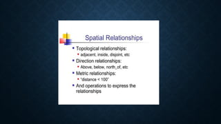
SPATIAL RELATIONSHIP
G.JERSHA
T.SAJITHA DEVI
INTRODUCTION
 In a Database Management System (DBMS), a spatial relationship refers to the way
geographical or geometric objects relate to each other in space.
 These spatial relationships are essential when dealing with spatial databases,
which store and manage spatial data such as points, lines, polygons, and other
geometrical objects.
 Spatial data is commonly used in geographic information systems (GIS), urban
planning, navigation, and many other fields where the location or arrangement of
objects in space matters.
In DBMS, spatial relationships refer to how geometric or geographical objects (like points,
lines, and polygons) relate to each other in space. Common types include:
Topological Relationships: Focus on object connectivity or adjacency (e.g., disjoint, intersect,
within).
Directional Relationships: Define the relative position of objects (e.g., left of, above).
Metric Relationships: Measure the distance between objects (e.g., nearest neighbor).
Proximity Relationships: Identify how close objects are (e.g., within a certain distance).
These relationships are crucial for spatial databases used in mapping, navigation, and
geographic analysis.
1.Topological Relationships
Examples:
• Disjoint:Two objects do not share any point.
• Touch:Two objects share a boundary but no interior points (e.g., adjacent parcels of
land).
• Intersect: Objects overlap or share some points in common.
• Contain/Within: One object is entirely inside another object (e.g., a lake inside a
park).
• Overlap:Two objects share some but not all of their areas.
2. Directional Relationships
• These describe the relative positioning of objects using
directions, such as north, south, east, and west.
Examples:
• Left of / Right of: An object is to the left or right side of
another object.
• Above / Below:Vertical positioning of objects.
• North of / South of: Based on geographical cardinal
directions.
3. Metric Relationships
These relationships use distance measures to determine how far
objects are from each other.
Examples:
• Distance:The physical distance between two spatial objects (e.g.,
"Object A is 5 km from Object B").
• Buffer: Defining a zone around a spatial object within a certain
distance (e.g., a 1 km buffer zone around a river).
4. Proximity Relationships
•Proximity describes how close spatial objects are to one
another.
Examples:
• Nearest Neighbor: Identifying the closest object to a
given point.
• Within a Distance: Checking if objects fall within a
specified distance from a reference object (e.g., "Find
all parks within 2 km of a school").
Use Cases
 GIS Systems:
Spatial relationships are fundamental in GIS for mapping and
analyzing geographical data.
 Navigation Systems:
Understanding proximity and direction for route planning.
 Urban Planning:
Managing relationships between buildings, roads, and other
infrastructure.
 Environmental Studies:
Analyzing ecological zones, species distribution, and natural
resources based on spatial relationships.
ADVANTAGES
The advantages of spatial relationships in DBMS include:
1.Efficient spatial queries for finding locations and analyzing overlaps.
2.Improved decision-making in urban planning, logistics, and more.
3.Essential for GIS, supporting mapping and geographic analysis.
4.Supports real-world applications like navigation and location-based services.
5.Optimization of routes and resource allocation.
6.Accurate modeling of real-world environments for better spatial analysis.
These benefits are crucial for fields involving geographic and spatial data.
DISADVANTAGES
Disadvantages of spatial relationships in DBMS include:
1.Complexity in managing and querying spatial data.
2.Increased storage requirements due to large spatial data sizes.
3.Performance overhead with slower spatial queries.
4.Need for specialized tools and extensions.
5.Limited standardization, causing compatibility issues.
These challenges make spatial data management more demanding
than traditional data.
TITLE LOREM IPSUM DOLOR
LOREM IPSUM DOLOR SIT
AMET, CONSECTETUER
ADIPISCING ELIT.
NUNC VIVERRA IMPERDIET
ENIM. FUSCE EST.VIVAMUS A
TELLUS.
LOREM IPSUM DOLOR SIT
AMET, CONSECTETUER
ADIPISCING ELIT.

Spatial relationship in Database management system

  • 1.
  • 2.
    INTRODUCTION  In aDatabase Management System (DBMS), a spatial relationship refers to the way geographical or geometric objects relate to each other in space.  These spatial relationships are essential when dealing with spatial databases, which store and manage spatial data such as points, lines, polygons, and other geometrical objects.  Spatial data is commonly used in geographic information systems (GIS), urban planning, navigation, and many other fields where the location or arrangement of objects in space matters.
  • 3.
    In DBMS, spatialrelationships refer to how geometric or geographical objects (like points, lines, and polygons) relate to each other in space. Common types include: Topological Relationships: Focus on object connectivity or adjacency (e.g., disjoint, intersect, within). Directional Relationships: Define the relative position of objects (e.g., left of, above). Metric Relationships: Measure the distance between objects (e.g., nearest neighbor). Proximity Relationships: Identify how close objects are (e.g., within a certain distance). These relationships are crucial for spatial databases used in mapping, navigation, and geographic analysis.
  • 5.
    1.Topological Relationships Examples: • Disjoint:Twoobjects do not share any point. • Touch:Two objects share a boundary but no interior points (e.g., adjacent parcels of land). • Intersect: Objects overlap or share some points in common. • Contain/Within: One object is entirely inside another object (e.g., a lake inside a park). • Overlap:Two objects share some but not all of their areas.
  • 6.
    2. Directional Relationships •These describe the relative positioning of objects using directions, such as north, south, east, and west. Examples: • Left of / Right of: An object is to the left or right side of another object. • Above / Below:Vertical positioning of objects. • North of / South of: Based on geographical cardinal directions.
  • 7.
    3. Metric Relationships Theserelationships use distance measures to determine how far objects are from each other. Examples: • Distance:The physical distance between two spatial objects (e.g., "Object A is 5 km from Object B"). • Buffer: Defining a zone around a spatial object within a certain distance (e.g., a 1 km buffer zone around a river).
  • 8.
    4. Proximity Relationships •Proximitydescribes how close spatial objects are to one another. Examples: • Nearest Neighbor: Identifying the closest object to a given point. • Within a Distance: Checking if objects fall within a specified distance from a reference object (e.g., "Find all parks within 2 km of a school").
  • 9.
    Use Cases  GISSystems: Spatial relationships are fundamental in GIS for mapping and analyzing geographical data.  Navigation Systems: Understanding proximity and direction for route planning.  Urban Planning: Managing relationships between buildings, roads, and other infrastructure.  Environmental Studies: Analyzing ecological zones, species distribution, and natural resources based on spatial relationships.
  • 10.
    ADVANTAGES The advantages ofspatial relationships in DBMS include: 1.Efficient spatial queries for finding locations and analyzing overlaps. 2.Improved decision-making in urban planning, logistics, and more. 3.Essential for GIS, supporting mapping and geographic analysis. 4.Supports real-world applications like navigation and location-based services. 5.Optimization of routes and resource allocation. 6.Accurate modeling of real-world environments for better spatial analysis. These benefits are crucial for fields involving geographic and spatial data.
  • 11.
    DISADVANTAGES Disadvantages of spatialrelationships in DBMS include: 1.Complexity in managing and querying spatial data. 2.Increased storage requirements due to large spatial data sizes. 3.Performance overhead with slower spatial queries. 4.Need for specialized tools and extensions. 5.Limited standardization, causing compatibility issues. These challenges make spatial data management more demanding than traditional data.
  • 12.
    TITLE LOREM IPSUMDOLOR LOREM IPSUM DOLOR SIT AMET, CONSECTETUER ADIPISCING ELIT. NUNC VIVERRA IMPERDIET ENIM. FUSCE EST.VIVAMUS A TELLUS. LOREM IPSUM DOLOR SIT AMET, CONSECTETUER ADIPISCING ELIT.