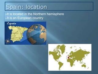
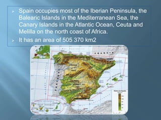
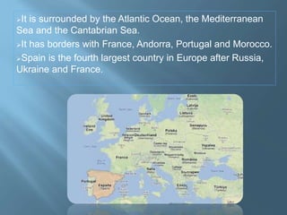
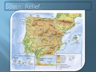
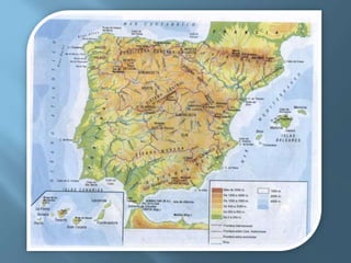
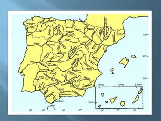
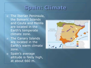
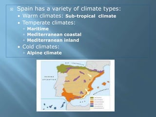
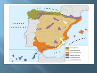
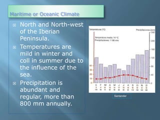
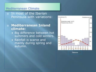
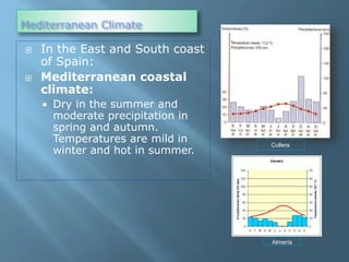
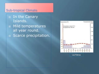
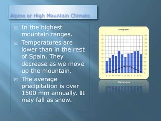
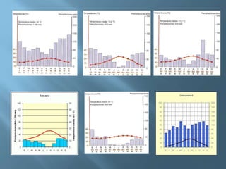
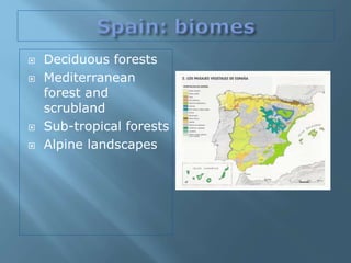
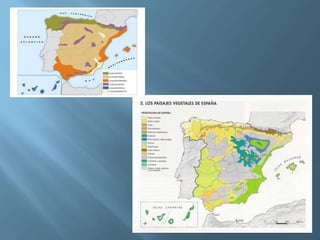
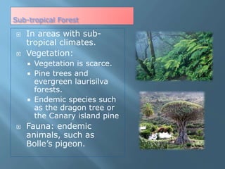
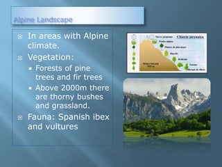
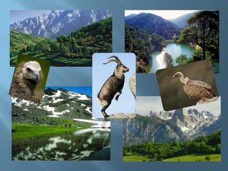
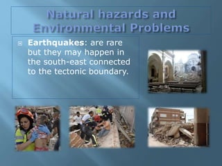
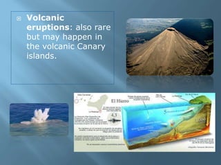
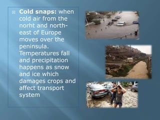
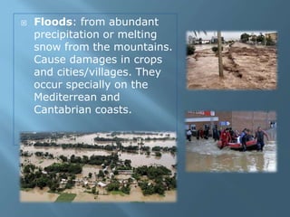
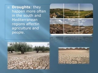
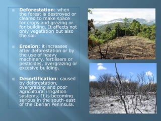
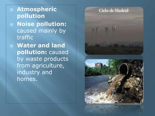
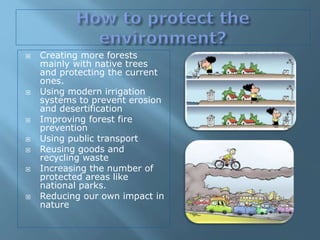
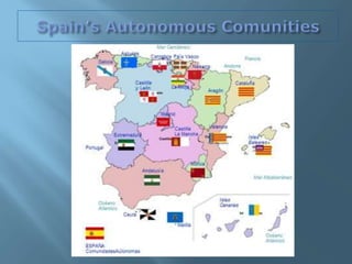
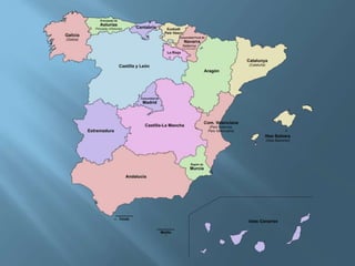
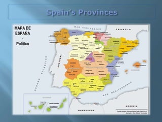
María Jesús Campos
learningfromgeography.wikispaces.com
Spain: location
It is located in the Northern hemisphere
It is an European country
 Spain occupies most of the Iberian Peninsula, the
Balearic Islands in the Mediterranean Sea, the
Canary Islands in the Atlantic Ocean, Ceuta and
Melilla on the north coast of Africa.
 It has an area of 505 370 km2
It is surrounded by the Atlantic Ocean, the Mediterranean
Sea and the Cantabrian Sea.
It has borders with France, Andorra, Portugal and Morocco.
Spain is the fourth largest country in Europe after Russia,
Ukraine and France.
Spain: Relief
 The Meseta Central (Central
Plateau) is divided in two parts
by the Sistema Central: it
divides the peninsula in 2
regions Submeseta Norte and
Submeseta Sur.
 Valleys:
• Depresión del Ebro,
• Depresión del Guadalquivir
 Highest Mountains:
 Pico Mulhacen (3479 m),
 Aneto (3404 m),
 Monte Perdido (3355 m),
 Torre Cerredo (2648 m),
 Pico Almanzor (2591 m),
 La Sagra (2382),
 Teleno (2188 m)
Main mountain ranges:
• Macizo Galaico-Leonés
• Montes de León
• Cordillera Cantábrica
• Montes Vascos
• Pirineos
• Cordillera Costero-
Catalana
• Sistema Ibérico
• Montes de Toledo
• Sistemas Béticos:
Cordillera Subbética
and Cordillera
Penibética
• Sierra Morena.
•
• Other mountain ranges:
• Pico de Europa,
• Sierra de Guadarrama
Somosierra,
• Sierra de la Demanda,
• Picos de Urbión,
• Serranía de Cuenca,
• El Maestrazgo,
• Sierra de Gredos,
• Sierra de Gata,
• Sierra de Guadalupe,
• Sierra de Aracena,
• Sierra de Alcudia,
• Sierra Madrona,
• Sierra de Cazorla,
• Sierra de Segura.
•Other:
• Golfo de Vizcaya
• Golfo de León
• Rías Gallegas
• Golfo de Valencia
• Golfo de Cádiz
• Estrecho de Gibraltar
• Cabo de Creus
• Cabo de la Nao
• Cabo de Palos
• Cabo de Gata
• Punta de Tarifa
• Cabo de Finisterre
• Punta de Estaca de Bares
 The relief of the Balearic Islands can be
considered a continuation of the Peninsula:
 Mallorca: Sierra de Tramuntana
 Menorca
 Ibiza
 Formentera
 Cabrera
 The relief of the Canary Islands is hilly and
of volcanic origin:
 Tenerife: Teide (3718 m) the highest
mountain of Spain
 Gran Canaria: Pico de las Nieves
(1949m)
 La Palma: Roque de los Muchachos
(2426m)
 Lanzarote
 Fuerteventura
 LaGomera
 El Hierro
 Most rivers flow irregularly
and are not navigable.
 The only navigable river is
River Guadalquivir
between Sevilla and the
Atlantic Ocean.
 Spain has got different
catchment areas:
 Cantabrian Sea basin:
short rivers with a
regular flow.
 Atlantic Ocean basin:
long rivers with an
irregular flow (except
River Miño)
 Mediterranean Sea
basin: short rivers with
an irregular flow (except
River Ebro)
 Cantabrian Sea’s catchment
areas rivers:
 Bidasoa, Nervión, Nalón
 Atlantic Ocean’s catchment
areas rivers:
 Miño, Duero, Tajo,
Guadiana, Guadalquivir
 Mediterranean Sea’s
catchment areas rivers:
 Ebro, Turia, Jucar, Segura
 Important tributaries:
 Miño: Sil
 Duero: Tormes, Esla,
Pisuerga, Arlanza, Eresma
 Tajo: Alagón, Tietar,
Alberche, Jarama, Henares
 Guadiana: Cigüela, Záncara,
Jabalón, Zújar
 Guadalquivir: Guadiato,
Genil
 Ebro: Aragón, Gállego,
Cinca, Segre, Guádalope
 The Iberian Peninsula,
the Balearic Islands
and Ceuta and Melilla
are located in the
Earth’s temperate
climate zone.
 The Canary Islands
are located in the
Earth’s warm climate
zone.
 Spain’s average
altitude is fairly high,
at about 660 m.
 Spain has a variety of climate types:
 Warm climates: Sub-tropical climate
 Temperate climates:
 Maritime
 Mediterranean coastal
 Mediterranean inland
 Cold climates:
 Alpine climate
Maritime or Oceanic Climate
 North and North-west
of the Iberian
Peninsula.
 Temperatures are
mild in winter and
coll in summer due to
the influence of the
sea.
 Precipitation is
abundant and
regular, more than
800 mm annually.
Santander
Mediterranean Climate
 In most of the Iberian
Peninsula with variations:
 Mediterranean Inland
climate:
 Big difference between hot
summers and cold winters.
 Rainfall is scarce and
mainly during spring and
autumn.
Talavera
Mediterranean Climate
 In the East and South coast
of Spain:
 Mediterranean coastal
climate:
 Dry in the summer and
moderate precipitation in
spring and autumn.
Temperatures are mild in
winter and hot in summer.
Cullera
Almería
Sub-tropical Climate
 In the Canary
Islands.
 Mild temperatures
all year round.
 Scarce precipitation.
Las Palmas
Alpine or High Mountain Climate
 In the highest
mountain ranges.
 Temperatures are
lower than in the rest
of Spain. They
decrease as we move
up the mountain.
 The average
precipitation is over
1500 mm annually. It
may fall as snow.
Benasque
 Deciduous forests
 Mediterranean
forest and
scrubland
 Sub-tropical forests
 Alpine landscapes
Deciduous Forests
 In areas with Maritime
climate
 Vegetation:
 Deciduous trees that lose
their leaves in autumn:
beech, oak.
 Also moorland and grassland.
 The indigenous vegetation
(oak trees, beech trees and
moors) has almost
dissaperared due to
extensive logging.
 Non-native vegetarion: pines
and ecucalyptus trees.
 Forests have been cut down
to make space for pastures,
for livestock or farmland.
 Fauna: capercaillies, hares,
otters, wolves, bears and
foxes
Mediterranean Forest and Scrubland
 In areas with
Mediterranean coastal
climate or
Mediterranean inland
climate.
 Vegetation:
 Trees that can survive
the dry summers: holm
oaks, cork oaks, pine
trees
 Bushes and aromatic
plants: lavender, thyme
 In Mediterranean inland
climate the main
landscape is the steppe.
 The territory has
suffered a severe
deforestation due to the
human use of the land
for agriculture and
livestock.
 Fauna: rabbits, wolves,
lynxes and imperial
eagles.
Sub-tropical Forest
 In areas with sub-
tropical climates.
 Vegetation:
 Vegetation is scarce.
 Pine trees and
evergreen laurisilva
forests.
 Endemic species such
as the dragon tree or
the Canary island pine
 Fauna: endemic
animals, such as
Bolle’s pigeon.
Alpine Landscape
 In areas with Alpine
climate.
 Vegetation:
 Forests of pine
trees and fir trees
 Above 2000m there
are thorny bushes
and grassland.
 Fauna: Spanish ibex
and vultures
 Earthquakes: are rare
but they may happen in
the south-east connected
to the tectonic boundary.
 Volcanic
eruptions: also rare
but may happen in
the volcanic Canary
islands.
 Cold snaps: when
cold air from the
norht and north-
east of Europe
moves over the
peninsula.
Temperatures fall
and precipitation
happens as snow
and ice which
damages crops and
affect transport
system
 Floods: from abundant
precipitation or melting
snow from the mountains.
Cause damages in crops
and cities/villages. They
occur specially on the
Mediterrean and
Cantabrian coasts.
 Droughts: they
happen more often
in the south and
Mediterranean
regions affectin
agriculture and
people.
 Deforestation: when
the forest is destroyed or
cleared to make space
for crops and grazing or
for building. It affects not
only vegetation but also
the soil
 Erosion: it increases
after deforestation or by
the use of heavy
machinery, fertilisers or
pesticides, overgrazing or
excesive building.
 Desertification: caused
by deforestation,
overgrazing and poor
agricultural irrigation
systems. It is becoming
serious in the south-east
of the Iberian Peninsula.
 Atmospheric
pollution
 Noise pollution:
caused mainly by
traffic
 Water and land
pollution: caused
by waste products
from agriculture,
industry and
homes.
 Creating more forests
mainly with native trees
and protecting the current
ones.
 Using modern irrigation
systems to prevent erosion
and desertification
 Improving forest fire
prevention
 Using public transport
 Reusing goods and
recycling waste
 Increasing the number of
protected areas like
national parks.
 Reducing our own impact in
nature
Developed by María Jesús Campos
Chusteacher
Wikiteacher

Spain: Physical Geography

  • 1.
  • 2.
    Spain: location It islocated in the Northern hemisphere It is an European country
  • 3.
     Spain occupiesmost of the Iberian Peninsula, the Balearic Islands in the Mediterranean Sea, the Canary Islands in the Atlantic Ocean, Ceuta and Melilla on the north coast of Africa.  It has an area of 505 370 km2
  • 4.
    It is surroundedby the Atlantic Ocean, the Mediterranean Sea and the Cantabrian Sea. It has borders with France, Andorra, Portugal and Morocco. Spain is the fourth largest country in Europe after Russia, Ukraine and France.
  • 5.
  • 6.
     The MesetaCentral (Central Plateau) is divided in two parts by the Sistema Central: it divides the peninsula in 2 regions Submeseta Norte and Submeseta Sur.  Valleys: • Depresión del Ebro, • Depresión del Guadalquivir  Highest Mountains:  Pico Mulhacen (3479 m),  Aneto (3404 m),  Monte Perdido (3355 m),  Torre Cerredo (2648 m),  Pico Almanzor (2591 m),  La Sagra (2382),  Teleno (2188 m)
  • 7.
    Main mountain ranges: •Macizo Galaico-Leonés • Montes de León • Cordillera Cantábrica • Montes Vascos • Pirineos • Cordillera Costero- Catalana • Sistema Ibérico • Montes de Toledo • Sistemas Béticos: Cordillera Subbética and Cordillera Penibética • Sierra Morena. •
  • 8.
    • Other mountainranges: • Pico de Europa, • Sierra de Guadarrama Somosierra, • Sierra de la Demanda, • Picos de Urbión, • Serranía de Cuenca, • El Maestrazgo, • Sierra de Gredos, • Sierra de Gata, • Sierra de Guadalupe, • Sierra de Aracena, • Sierra de Alcudia, • Sierra Madrona, • Sierra de Cazorla, • Sierra de Segura.
  • 9.
    •Other: • Golfo deVizcaya • Golfo de León • Rías Gallegas • Golfo de Valencia • Golfo de Cádiz • Estrecho de Gibraltar • Cabo de Creus • Cabo de la Nao • Cabo de Palos • Cabo de Gata • Punta de Tarifa • Cabo de Finisterre • Punta de Estaca de Bares
  • 10.
     The reliefof the Balearic Islands can be considered a continuation of the Peninsula:  Mallorca: Sierra de Tramuntana  Menorca  Ibiza  Formentera  Cabrera  The relief of the Canary Islands is hilly and of volcanic origin:  Tenerife: Teide (3718 m) the highest mountain of Spain  Gran Canaria: Pico de las Nieves (1949m)  La Palma: Roque de los Muchachos (2426m)  Lanzarote  Fuerteventura  LaGomera  El Hierro
  • 12.
     Most riversflow irregularly and are not navigable.  The only navigable river is River Guadalquivir between Sevilla and the Atlantic Ocean.  Spain has got different catchment areas:  Cantabrian Sea basin: short rivers with a regular flow.  Atlantic Ocean basin: long rivers with an irregular flow (except River Miño)  Mediterranean Sea basin: short rivers with an irregular flow (except River Ebro)
  • 14.
     Cantabrian Sea’scatchment areas rivers:  Bidasoa, Nervión, Nalón  Atlantic Ocean’s catchment areas rivers:  Miño, Duero, Tajo, Guadiana, Guadalquivir  Mediterranean Sea’s catchment areas rivers:  Ebro, Turia, Jucar, Segura  Important tributaries:  Miño: Sil  Duero: Tormes, Esla, Pisuerga, Arlanza, Eresma  Tajo: Alagón, Tietar, Alberche, Jarama, Henares  Guadiana: Cigüela, Záncara, Jabalón, Zújar  Guadalquivir: Guadiato, Genil  Ebro: Aragón, Gállego, Cinca, Segre, Guádalope
  • 16.
     The IberianPeninsula, the Balearic Islands and Ceuta and Melilla are located in the Earth’s temperate climate zone.  The Canary Islands are located in the Earth’s warm climate zone.  Spain’s average altitude is fairly high, at about 660 m.
  • 17.
     Spain hasa variety of climate types:  Warm climates: Sub-tropical climate  Temperate climates:  Maritime  Mediterranean coastal  Mediterranean inland  Cold climates:  Alpine climate
  • 19.
    Maritime or OceanicClimate  North and North-west of the Iberian Peninsula.  Temperatures are mild in winter and coll in summer due to the influence of the sea.  Precipitation is abundant and regular, more than 800 mm annually. Santander
  • 20.
    Mediterranean Climate  Inmost of the Iberian Peninsula with variations:  Mediterranean Inland climate:  Big difference between hot summers and cold winters.  Rainfall is scarce and mainly during spring and autumn. Talavera
  • 21.
    Mediterranean Climate  Inthe East and South coast of Spain:  Mediterranean coastal climate:  Dry in the summer and moderate precipitation in spring and autumn. Temperatures are mild in winter and hot in summer. Cullera Almería
  • 22.
    Sub-tropical Climate  Inthe Canary Islands.  Mild temperatures all year round.  Scarce precipitation. Las Palmas
  • 23.
    Alpine or HighMountain Climate  In the highest mountain ranges.  Temperatures are lower than in the rest of Spain. They decrease as we move up the mountain.  The average precipitation is over 1500 mm annually. It may fall as snow. Benasque
  • 25.
     Deciduous forests Mediterranean forest and scrubland  Sub-tropical forests  Alpine landscapes
  • 27.
    Deciduous Forests  Inareas with Maritime climate  Vegetation:  Deciduous trees that lose their leaves in autumn: beech, oak.  Also moorland and grassland.  The indigenous vegetation (oak trees, beech trees and moors) has almost dissaperared due to extensive logging.  Non-native vegetarion: pines and ecucalyptus trees.  Forests have been cut down to make space for pastures, for livestock or farmland.  Fauna: capercaillies, hares, otters, wolves, bears and foxes
  • 29.
    Mediterranean Forest andScrubland  In areas with Mediterranean coastal climate or Mediterranean inland climate.  Vegetation:  Trees that can survive the dry summers: holm oaks, cork oaks, pine trees  Bushes and aromatic plants: lavender, thyme
  • 30.
     In Mediterraneaninland climate the main landscape is the steppe.  The territory has suffered a severe deforestation due to the human use of the land for agriculture and livestock.  Fauna: rabbits, wolves, lynxes and imperial eagles.
  • 32.
    Sub-tropical Forest  Inareas with sub- tropical climates.  Vegetation:  Vegetation is scarce.  Pine trees and evergreen laurisilva forests.  Endemic species such as the dragon tree or the Canary island pine  Fauna: endemic animals, such as Bolle’s pigeon.
  • 34.
    Alpine Landscape  Inareas with Alpine climate.  Vegetation:  Forests of pine trees and fir trees  Above 2000m there are thorny bushes and grassland.  Fauna: Spanish ibex and vultures
  • 36.
     Earthquakes: arerare but they may happen in the south-east connected to the tectonic boundary.
  • 37.
     Volcanic eruptions: alsorare but may happen in the volcanic Canary islands.
  • 38.
     Cold snaps:when cold air from the norht and north- east of Europe moves over the peninsula. Temperatures fall and precipitation happens as snow and ice which damages crops and affect transport system
  • 39.
     Floods: fromabundant precipitation or melting snow from the mountains. Cause damages in crops and cities/villages. They occur specially on the Mediterrean and Cantabrian coasts.
  • 40.
     Droughts: they happenmore often in the south and Mediterranean regions affectin agriculture and people.
  • 41.
     Deforestation: when theforest is destroyed or cleared to make space for crops and grazing or for building. It affects not only vegetation but also the soil  Erosion: it increases after deforestation or by the use of heavy machinery, fertilisers or pesticides, overgrazing or excesive building.  Desertification: caused by deforestation, overgrazing and poor agricultural irrigation systems. It is becoming serious in the south-east of the Iberian Peninsula.
  • 42.
     Atmospheric pollution  Noisepollution: caused mainly by traffic  Water and land pollution: caused by waste products from agriculture, industry and homes.
  • 43.
     Creating moreforests mainly with native trees and protecting the current ones.  Using modern irrigation systems to prevent erosion and desertification  Improving forest fire prevention  Using public transport  Reusing goods and recycling waste  Increasing the number of protected areas like national parks.  Reducing our own impact in nature
  • 47.
    Developed by MaríaJesús Campos Chusteacher Wikiteacher