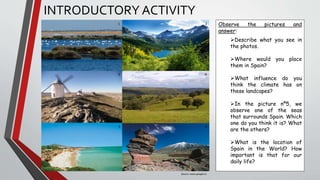
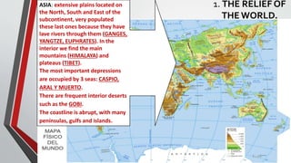
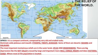
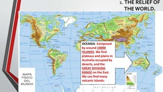
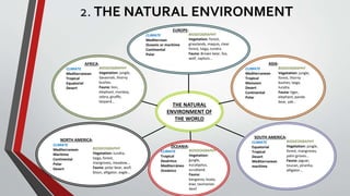
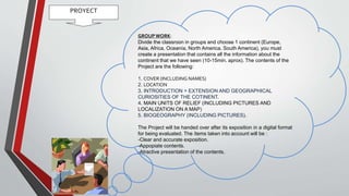
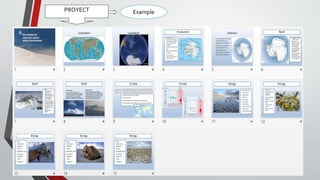
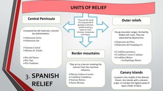
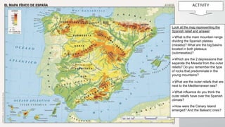
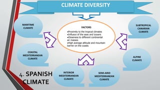
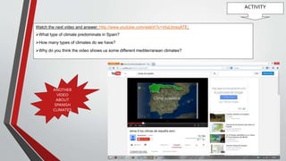
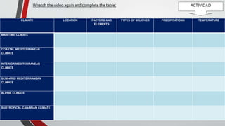
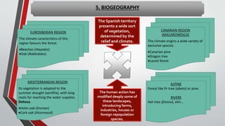
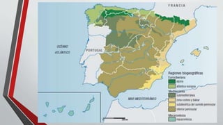
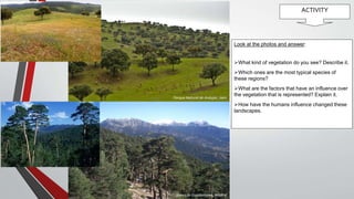
2. INTRODUCTORY ACTIVITY
1 2
3 4
5 6
Observe the pictures and
answer:
Describe what you see in
the photos.
Where would you place
them in Spain?
What influence do you
think the climate has on
these landcapes?
In the picture nº5, we
observe one of the seas
that surrounds Spain. Which
one do you think it is? What
are the others?
What is the location of
Spain in the World? How
important is that for our
daily life?
Source: www.google.es
7. 1. THE RELIEF OF
THEWORLD. AMERICA:
The greatest mountain ranges are
extended parallel to the Pacific
coastline, which has vital influence
on the climate and life : ROCKY
MOUNTAINS, SIERRA MADRE Y
LOS ANDES. This creates deserts
like the COLORADO, coastal desert
is the ATACAMA.
in the interior there are extensive
plateaus : MATO GROSSO AND
COLORADO; and plains : GREAT
PLAINS, GRAN CHACO, LA PAMPA.
On the East we find old and
eroded massifs : APALACHES,
GUAYANAS.
The coasts are abrupt and narrow,
where most of the population
lives.
8. 1. THE RELIEF OF
THEWORLD.
ASIA: extensive plains located on
the North, South and East of the
subcontinent, very populated
these last ones because they have
lave rivers through them (GANGES,
YANGTZE, EUPHRATES). In the
interior we find the main
mountains (HIMALAYA) and
plateaus (TIBET).
The most important depressions
are occupied by 3 seas: CASPIO,
ARAL Y MUERTO.
There are frequent interior deserts
such as the GOBI.
The coastline is abrupt, with many
penínsulas, gulfs and islands.
9. 1. THE RELIEF OF
THEWORLD.
AFRICA: It is a compact continent, composed by very old and eroded rocks.
Dominate wide plateaus and massifs: ETHIOPIA, TIBESTI, AHAGGAR. Some of them are deserts: SAHARA and
KALAHARI.
The most important montainous reliefs are in the outer lands: ATLAS AND DRAKENSBERG. There are big
deprresions like the RIFT VALLEY crossed by large and important rivers (NILE, CONGO, NÍGER) and lakes (VICTORIA,
CHAD). Where most ot the population is located.
10. OCEANIA: Composed
by around 10000
ISLANDS. We find
plateaus and plains in
Australia occupied by
deserts, and the
GREAT DIVIDING
RANGE on the East.
We can find many
volcanic islands.
1. THE RELIEF OF
THEWORLD.
11. ACTIVITY
Fuente: http://juanbascon.blogspot.com.es/
Observe the pictures and answer:
What kind of relief are they showing?
Locate on the world map 5 examples
of these reliefs.
Map link:
http://2.bp.blogspot.com/-
HI25sXh7Ytw/UXb93V0-
rrI/AAAAAAAAAQg/ud5CpuUbJAM/s16
00/mapa-fc3adsico-del-mundo.jpg
Source: http://juanbascon.blogspot.com.es/
13. PROYECT
GROUPWORK:
Divide the classroon in groups and choose 1 continent (Europe,
Asia, Africa, Oceanía, North America, South America), you must
create a presentation that contains all the information about the
continent that we have seen (10-15min. aprox). The contents of the
Project are the following:
1. COVER (INCLUDING NAMES)
2. LOCATION
3. INTRODUCTION > EXTENSION AND GEOGRAPHICAL
CURIOSITIES OF THE COTINENT.
4. MAIN UNITS OF RELIEF (INCLUDING PICTURES AND
LOCALIZATION ON A MAP)
5. BIOGEOGRAPHY (INCLUDING PICTURES).
The Project will be handed over after its exposition in a digital format
for being evaluated. The ítems taken into account will be :
-Clear and accurate exposition.
-Appopiate contents.
-Atractive presentation of the contents.
15. They are the result
of a long period of
geologic evolution,
predominating 3
types of rocks:
siliceous, limestones
and clayey.
3. SPANISH
RELIEF
UNITS OF RELIEF
Composed by old materials, covered
by sedimentation.
Submeseta Norte
Submeseta Sur
Sistema Central
Montes de Toledo
Río del Duero
Río Tajo
Río Guadiana
Central Peninsula
Border mountains
They act as a barrier isolating the
interior from the maritime
influence.
Macizo Galaico-Leonés
Cordillera Cantábrica
Sistema Ibérico
Sierra Morena
Outer reliefs
Young mountain ranges, formed by
folded soft rocks. They are
separated by depressions.
Depresión del Ebro
Depresión del Guadalquivir
Cordillera pirenaica
Cordillera Costera Catalana
Cordillera Bética
oArchipiélago Balear
Canary Islands
Located in the middle of the Atlantic
Ocean. Are islands with a volcanic
origin. It includes the highest peak of
Spain (Teide 3718m).
17. ACTIVITY
Look at the map representing the
Spanish relief and answer:
What is the main mountain range
dividing the Spanish plateau
(meseta)? What are the big basins
located in both plateaus
(submesetas)?
Which are the 2 depressions that
separate the Meseta from the outer
reliefs? Do you remember the type
of rocks that predominate in the
young mountains?
What are the outer reliefs that are
next to the Mediterranean sea?
What influence do you think the
outer reliefs have over the Spanish
climate?
How were the Canary Island
emerged? And the Balearic ones?
19. ACTIVITY
Watch the next video and answer: http://www.youtube.com/watch?v=VIqLlmsqATE:
What type of climate predominate in Spain?
How many types of climates do we have?
Why do you think the video shows us some different mediterranean climates?
ANOTHER
VIDEO
ABOUT
SPANISH
CLIMATES
20. Whatch the video again and complete the table: ACTIVIDAD
CLIMATE LOCATION FACTORS AND
ELEMENTS
TYPES OF WEATHER PRECIPITATIONS TEMPERATURE
MARITIME CLIMATE
COASTAL MEDITERRANEAN
CLIMATE
INTERIOR MEDITERRANEAN
CLIMATE
SEMI-ARID MEDITERRANEAN
CLIMATE
ALPINE CLIMATE
SUBTROPICAL CANARIAN CLIMATE
21. 5. BIOGEOGRAPHY
The Spanish territory
presents a wide sort
of vegetation,
determined by the
relief and climate.
The human action has
modified deeply some of
these landscapes,
introducing farms,
industries, houses or
foreign repopulation
species.
EUROSIBERIAN REGION
The climate caracteristics of this
region favours the forest.
Beeches (Hayedos)
Oak (Robledales)
MEDITERRANEAN REGION
Its vegetation is adapted to the
summer drought (xerófila), with long
roots for reaching the water supplies.
Dehesa.
Holm oak (Encinar)
Cork oak (Alcornocal)
CANARIAN REGION
(MACARONÉSICA)
The climate origins a wide variety of
exclusive species.
Canarian pine
Dragon tree
Laurel forest
ALPINE
Forest like fir tree (abeto) or pine.
RIVERS
Ash tree (fresno), elm…
22.
23. ACTIVITY
Parque Natural de Andújar, Jaén
Sierra de Guadarrama, Madrid
Look at the photos and answer:
What kind of vegetation do you see? Describe it.
Which ones are the most typical species of
these regions?
What are the factors that have an influence over
the vegetation that is represented? Explain it.
How have the humans influence changed these
landscapes.
24. VOCABULARY
• Mountain range
• Plateau
• Plain
• Hill
• Valley
• Depression
• Archipelago
• Ria
• Peninsula
• Gulf
• Bay
• Cape
• Marsh
• Delta
• Estuary
• Cliff
• River basin