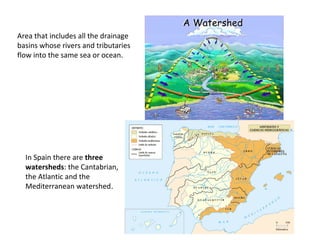
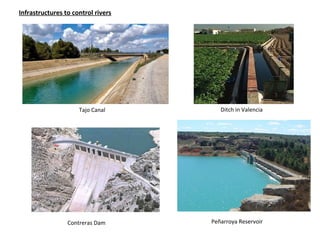
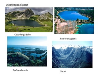
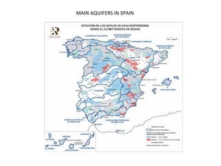
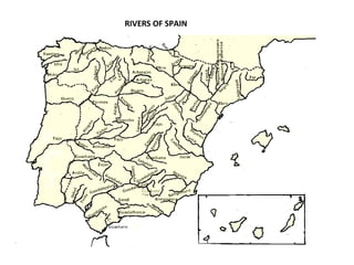
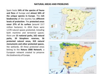
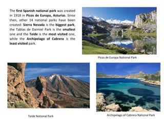
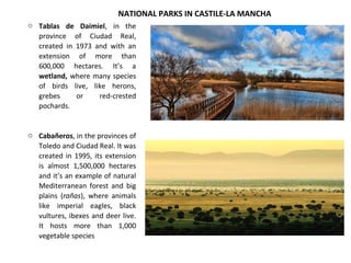
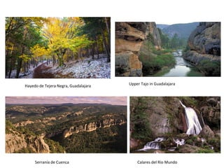
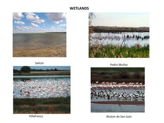
PHYSICAL GEOGRAPHY OF SPAIN
Spain is a very mountainous country, due to the numerous mountain ranges and the Central
Plateau. The average altitude is 650 m. This makes communications difficult.
SPAIN’S RELIEF
- CENTRAL PLATEAU
- Parts : Northern Sub-Plateau and Southern Sub-Plateau
- Mountain ranges: Central System and Toledo Mountains
- MOUNTAIN RANGES THAT
RIM THE CENTRAL PLATEAU
- León Mountains
- Cantabrian Mountains
- Iberian System
- Sierra Morena
- MOUNTAIN RANGES OUTSIDE
THE CENTRAL PLATEAU
- LOWLANDS
- Galician Massif
- Pyrenees
- Catalan Mediterranean System (Catalan Pre-
Coastal Range and Catalan Coastal Range)
- Baetic System (Pre-Baetic System, Subbaetic
System and Penibaetic System)
PENINSULA
- Ebro Basin
- Andalusian Plain
ARCHIPELAGOS
-BALEARIC ISLANDS. 4 major islands and 144 islets
-CANARY ISLANDS: 7 major islands and 2 smaller ones. Volcanic origin
COASTS
- Generally straight coasts, with the exception of Galicia, whose
coasts are very much trimmed by the rías formed in the mouth
of some rivers. The Upper Rías (Viveiro, Foz, Ortigueira) are
short and narrow, while the Lower Rías are deeper and wider.
- High and rocky coasts predominate, especially in the
Cantabrian coast and Catalonia, where there are many cliffs
due to the proximity of the mountains to the sea.
- The plain areas, with sandy beaches, are located in the gulfs of
Valencia, Alicante and Cádiz. Lowlands are also found on the
mouths of rivers Tagus and Guadiana, on the Portuguese
coast.
- The coasts of the Balearic Islands combine
beaches, cliffs and small coves.
- In the Canary Islands there are also cliffs and
sandy and rocky beaches.
ARCHIPELAGOS
PENINSULA
UPPER RÍAS
LOWER RÍAS
Ría of Vigo
Cliffs in Liencres, Cantabria
Bolonia Beach, Cádiz
HYDROSPHERE
- SALT WATER
OCEANS
SEAS
-FRESH WATER
- SURFACE WATERS
- UNDERGROUND WATERS: AQUIFERS
-RIVERS
-LAKES
-LAGOONS
-GLACIERS
HYDROGRAPHY
RIVERS
Rivers are continuous currents of fresh water that flow into the sea or another body of
water, like a lake or another river. Rivers have different parts:
River course
Area that includes all the drainage
basins whose rivers and tributaries
flow into the same sea or ocean.
In Spain there are three
watersheds: the Cantabrian,
the Atlantic and the
Mediterranean watershed.
Tajo Canal Ditch in Valencia
Contreras Dam Peñarroya Reservoir
Infrastructures to control rivers
Covadonga Lake
Ruidera Lagoons
Doñana Marsh Glacier
Other bodies of water
MAIN AQUIFERS IN SPAIN
RIVERS OF SPAIN
CANTABRIAN
WATERSHED
- Location: North of the Iberian Peninsula. Rivers whose waters run
into the Bay of Biscay and Cantabrian Sea
- Features: short, high discharge and regular regime
- Main rivers: Eo, Navia, Nalón, Saja, Besaya, Pas, Nervión and
Bidasoa
ATLANTIC
WATERSHED
MEDITERRANEAN
WATERSHED
- Location: West of the Iberian Peninsula, rivers whose waters flow
into the Atlantic Ocean, mostly born in the mountains of the East
(Iberian and Baetic System)
- Features: the rivers of the Central Plateau are long, with a high
discharge and irregular regime. The Galician and Andalusian rivers
are shorter
- Main rivers: Eume, Ulla, Tambre, Miño, Duero, Tagus, Guadiana,
Guadalquivir, Odiel, Tinto, Guadalete and Barbate.
- Location: East of the Iberian Peninsula. Rivers whose waters flow into
the Mediterranean Sea
- Features: Except for the Ebro (long and with a high discharge), they
are short, with a low discharge and irregular regime. There are also
ramblas.
- Main rivers: Ter, Llobregat, Ebro, Mijares, Turia, Júcar, Segura,
Almanzora and Guadalhorce
RIVERS
OF SPAIN
ARCHIPELAGOS
- Balearic Islands: no rivers, but torrents, like the Torrent of Na
Borges and the Torrent of Muro
- Canary Islands: no rivers, but ravines, like the Barrancos of La
Aldea, El Rey and Taburiente.
Spain hosts 54% of the species of fauna
and flora of Europe and almost 50% of
the unique species in Europe. The rich
biodiversity of the country has different
levels of protection. The protected areas
cover 27% of its surface (around 13.7
million hectares). In 2014 there were
1,570 natural spaces protected, including
both maritime and terrestrial spaces:
there are 15 national parks, 162 natural
parks, 39 biosphere reserves, 56
protected natural areas, 319 natural
monuments and other protected spaces,
like wetlands. All these protected areas
belong to the Natura 2000 Network, a
European network created to preserve
the biodiversity of Europe.
NATURAL AREAS AND PROBLEMS
The first Spanish national park was created
in 1918 in Picos de Europa, Asturias. Since
then, other 14 national parks have been
created: Sierra Nevada is the biggest park,
the Tablas de Daimiel Park is the smallest
one and the Teide is the most visited one,
while the Archipelago of Cabrera is the
least visited park.
Picos de Europa National Park
Archipelago of Cabrera National ParkTeide National Park
o Tablas de Daimiel, in the
province of Ciudad Real,
created in 1973 and with an
extension of more than
600,000 hectares. It’s a
wetland, where many species
of birds live, like herons,
grebes or red-crested
pochards.
o Cabañeros, in the provinces of
Toledo and Ciudad Real. It was
created in 1995, its extension
is almost 1,500,000 hectares
and it’s an example of natural
Mediterranean forest and big
plains (rañas), where animals
like imperial eagles, black
vultures, ibexes and deer live.
It hosts more than 1,000
vegetable species
NATIONAL PARKS IN CASTILE-LA MANCHA
Hayedo de Tejera Negra, Guadalajara Upper Tajo in Guadalajara
Serranía de Cuenca Calares del Río Mundo
Salicor
Villafranca
Pedro Muñoz
Alcázar de San Juan
WETLANDS

Spain's relief, rivers and protected environments

  • 1.
  • 2.
    Spain is avery mountainous country, due to the numerous mountain ranges and the Central Plateau. The average altitude is 650 m. This makes communications difficult.
  • 3.
    SPAIN’S RELIEF - CENTRALPLATEAU - Parts : Northern Sub-Plateau and Southern Sub-Plateau - Mountain ranges: Central System and Toledo Mountains - MOUNTAIN RANGES THAT RIM THE CENTRAL PLATEAU - León Mountains - Cantabrian Mountains - Iberian System - Sierra Morena - MOUNTAIN RANGES OUTSIDE THE CENTRAL PLATEAU - LOWLANDS - Galician Massif - Pyrenees - Catalan Mediterranean System (Catalan Pre- Coastal Range and Catalan Coastal Range) - Baetic System (Pre-Baetic System, Subbaetic System and Penibaetic System) PENINSULA - Ebro Basin - Andalusian Plain ARCHIPELAGOS -BALEARIC ISLANDS. 4 major islands and 144 islets -CANARY ISLANDS: 7 major islands and 2 smaller ones. Volcanic origin
  • 4.
    COASTS - Generally straightcoasts, with the exception of Galicia, whose coasts are very much trimmed by the rías formed in the mouth of some rivers. The Upper Rías (Viveiro, Foz, Ortigueira) are short and narrow, while the Lower Rías are deeper and wider. - High and rocky coasts predominate, especially in the Cantabrian coast and Catalonia, where there are many cliffs due to the proximity of the mountains to the sea. - The plain areas, with sandy beaches, are located in the gulfs of Valencia, Alicante and Cádiz. Lowlands are also found on the mouths of rivers Tagus and Guadiana, on the Portuguese coast. - The coasts of the Balearic Islands combine beaches, cliffs and small coves. - In the Canary Islands there are also cliffs and sandy and rocky beaches. ARCHIPELAGOS PENINSULA
  • 5.
    UPPER RÍAS LOWER RÍAS Ríaof Vigo Cliffs in Liencres, Cantabria Bolonia Beach, Cádiz
  • 6.
    HYDROSPHERE - SALT WATER OCEANS SEAS -FRESHWATER - SURFACE WATERS - UNDERGROUND WATERS: AQUIFERS -RIVERS -LAKES -LAGOONS -GLACIERS HYDROGRAPHY
  • 7.
    RIVERS Rivers are continuouscurrents of fresh water that flow into the sea or another body of water, like a lake or another river. Rivers have different parts:
  • 8.
  • 9.
    Area that includesall the drainage basins whose rivers and tributaries flow into the same sea or ocean. In Spain there are three watersheds: the Cantabrian, the Atlantic and the Mediterranean watershed.
  • 10.
    Tajo Canal Ditchin Valencia Contreras Dam Peñarroya Reservoir Infrastructures to control rivers
  • 11.
    Covadonga Lake Ruidera Lagoons DoñanaMarsh Glacier Other bodies of water
  • 12.
  • 13.
  • 14.
    CANTABRIAN WATERSHED - Location: Northof the Iberian Peninsula. Rivers whose waters run into the Bay of Biscay and Cantabrian Sea - Features: short, high discharge and regular regime - Main rivers: Eo, Navia, Nalón, Saja, Besaya, Pas, Nervión and Bidasoa ATLANTIC WATERSHED MEDITERRANEAN WATERSHED - Location: West of the Iberian Peninsula, rivers whose waters flow into the Atlantic Ocean, mostly born in the mountains of the East (Iberian and Baetic System) - Features: the rivers of the Central Plateau are long, with a high discharge and irregular regime. The Galician and Andalusian rivers are shorter - Main rivers: Eume, Ulla, Tambre, Miño, Duero, Tagus, Guadiana, Guadalquivir, Odiel, Tinto, Guadalete and Barbate. - Location: East of the Iberian Peninsula. Rivers whose waters flow into the Mediterranean Sea - Features: Except for the Ebro (long and with a high discharge), they are short, with a low discharge and irregular regime. There are also ramblas. - Main rivers: Ter, Llobregat, Ebro, Mijares, Turia, Júcar, Segura, Almanzora and Guadalhorce RIVERS OF SPAIN ARCHIPELAGOS - Balearic Islands: no rivers, but torrents, like the Torrent of Na Borges and the Torrent of Muro - Canary Islands: no rivers, but ravines, like the Barrancos of La Aldea, El Rey and Taburiente.
  • 15.
    Spain hosts 54%of the species of fauna and flora of Europe and almost 50% of the unique species in Europe. The rich biodiversity of the country has different levels of protection. The protected areas cover 27% of its surface (around 13.7 million hectares). In 2014 there were 1,570 natural spaces protected, including both maritime and terrestrial spaces: there are 15 national parks, 162 natural parks, 39 biosphere reserves, 56 protected natural areas, 319 natural monuments and other protected spaces, like wetlands. All these protected areas belong to the Natura 2000 Network, a European network created to preserve the biodiversity of Europe. NATURAL AREAS AND PROBLEMS
  • 16.
    The first Spanishnational park was created in 1918 in Picos de Europa, Asturias. Since then, other 14 national parks have been created: Sierra Nevada is the biggest park, the Tablas de Daimiel Park is the smallest one and the Teide is the most visited one, while the Archipelago of Cabrera is the least visited park. Picos de Europa National Park Archipelago of Cabrera National ParkTeide National Park
  • 17.
    o Tablas deDaimiel, in the province of Ciudad Real, created in 1973 and with an extension of more than 600,000 hectares. It’s a wetland, where many species of birds live, like herons, grebes or red-crested pochards. o Cabañeros, in the provinces of Toledo and Ciudad Real. It was created in 1995, its extension is almost 1,500,000 hectares and it’s an example of natural Mediterranean forest and big plains (rañas), where animals like imperial eagles, black vultures, ibexes and deer live. It hosts more than 1,000 vegetable species NATIONAL PARKS IN CASTILE-LA MANCHA
  • 18.
    Hayedo de TejeraNegra, Guadalajara Upper Tajo in Guadalajara Serranía de Cuenca Calares del Río Mundo
  • 19.