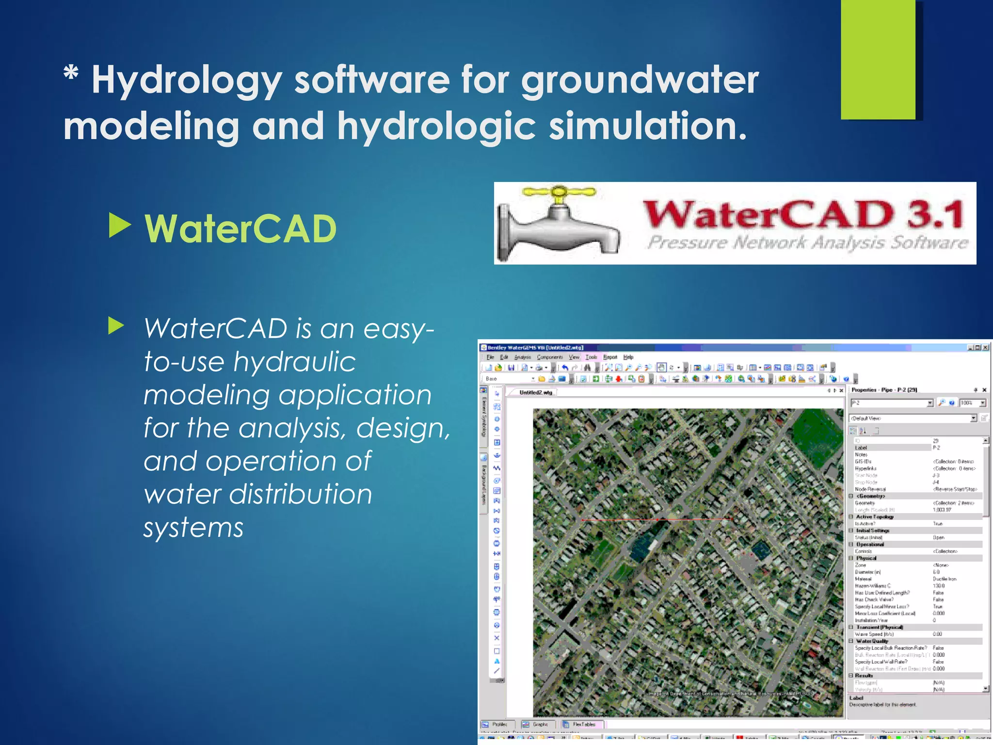
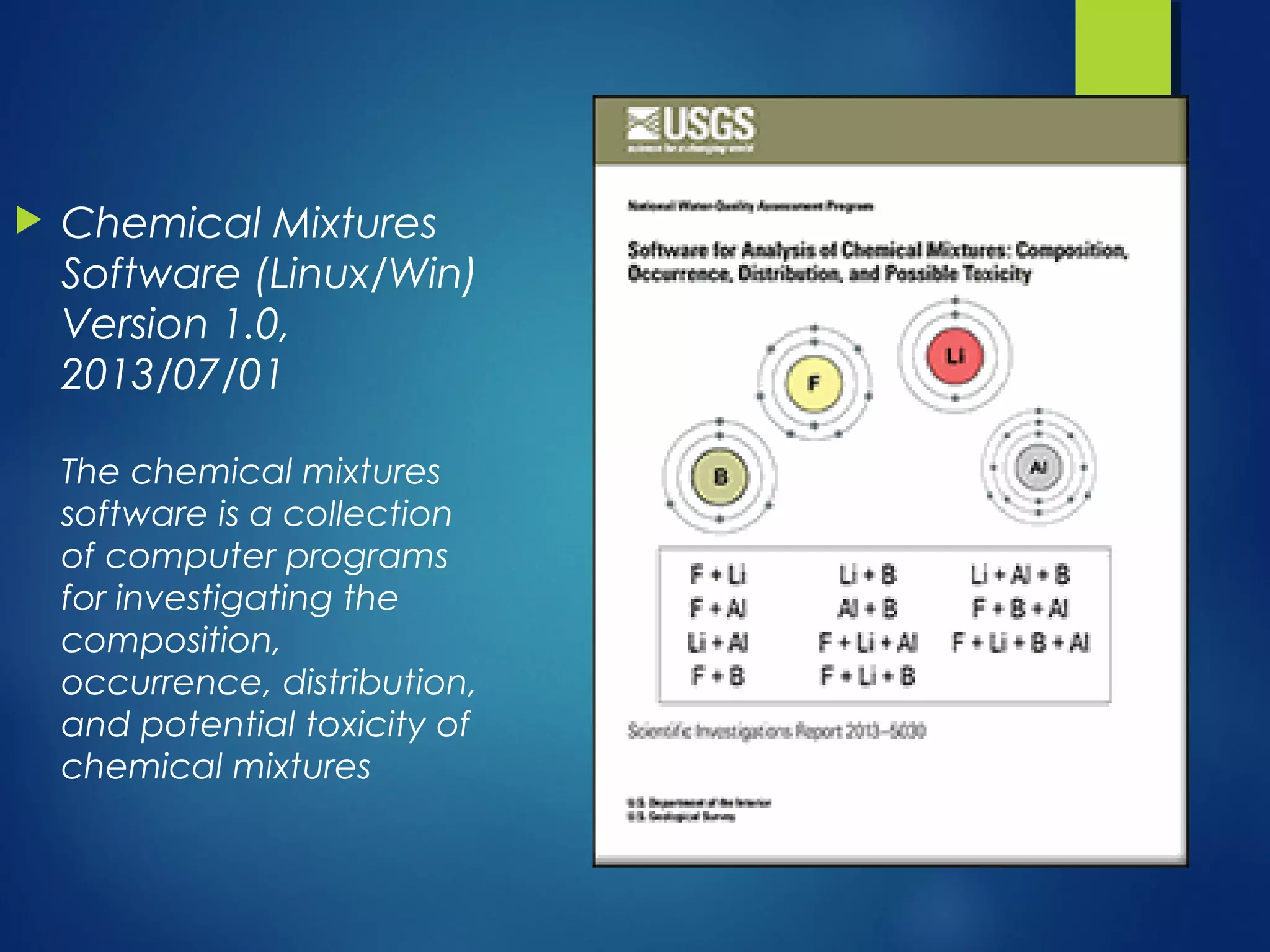
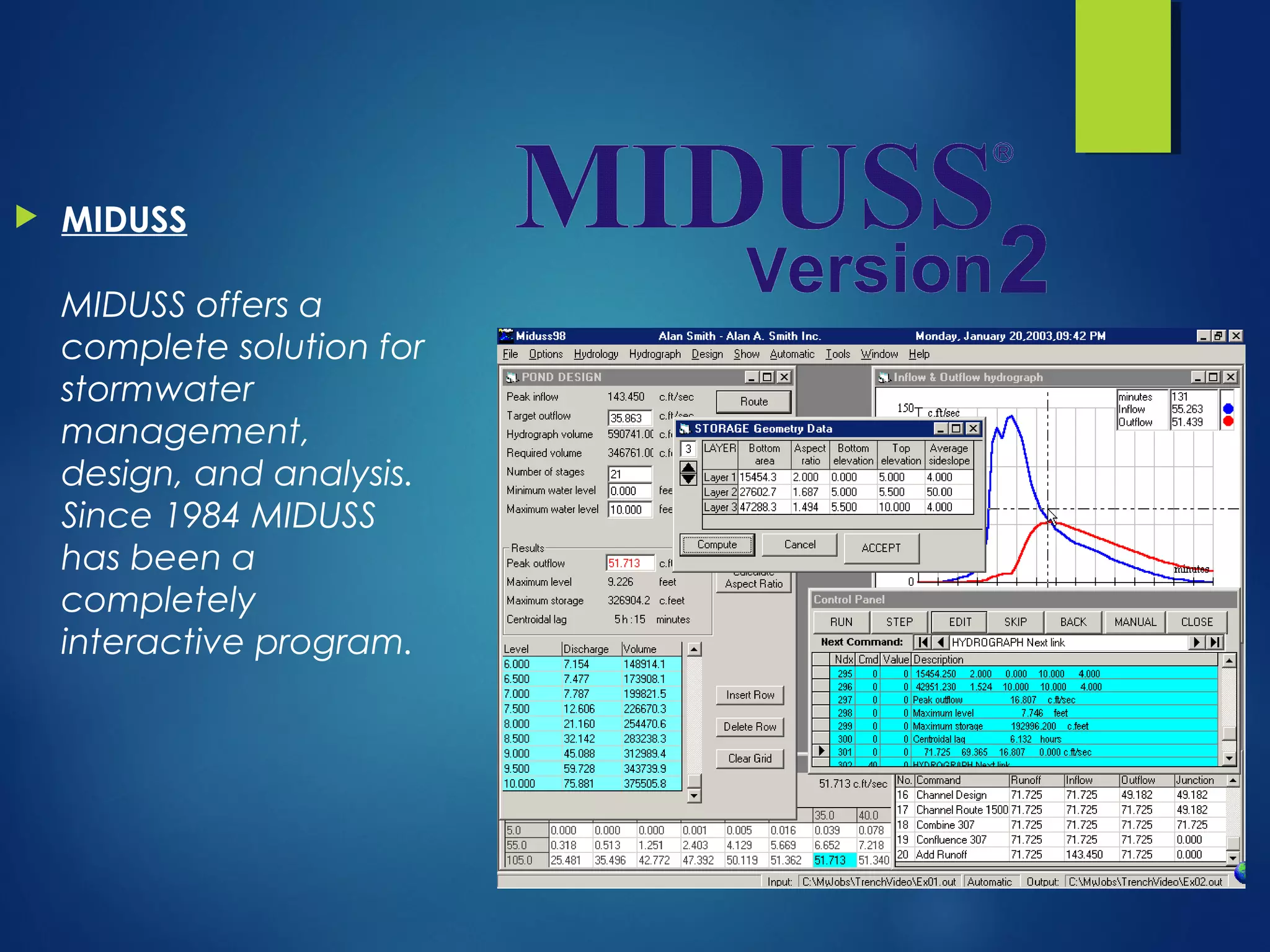
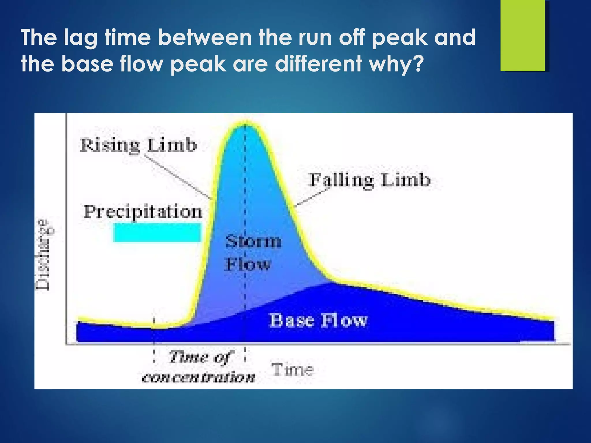
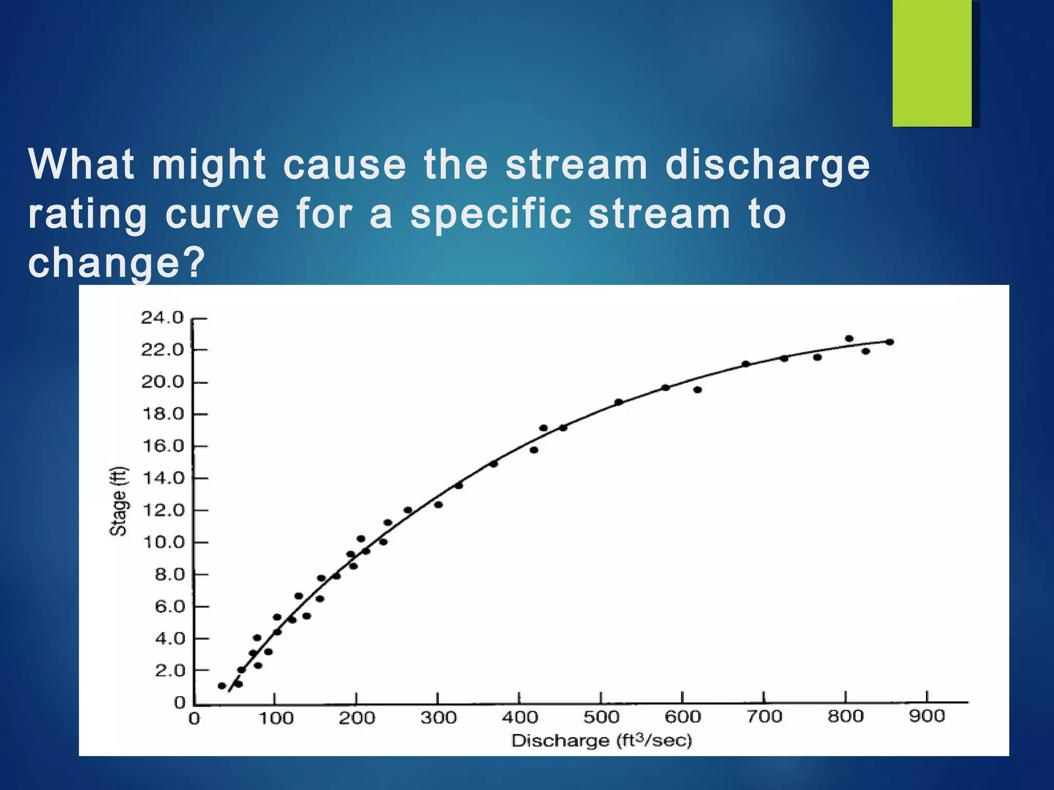
> Software Used in
Hydrology
BY
Shayan Ahmad Yar
BS-VI
DEPARTMENT OF GEOLOGY, BACHA KHAN UNIVERSITY
* Hydrology software for groundwater
modeling and hydrologic simulation.
 WaterCAD
 WaterCAD is an easy-
to-use hydraulic
modeling application
for the analysis, design,
and operation of
water distribution
systems
 RIVERMorph
The RIVERMorph® software is a
database oriented software
system geared towards channel
measurement data
collection/storage, reference
reach data collection/storage,
river assessment/monitoring and
engineering applications
including natural channel design
 Chemical Mixtures
Software (Linux/Win)
Version 1.0,
2013/07/01
The chemical mixtures
software is a collection
of computer programs
for investigating the
composition,
occurrence, distribution,
and potential toxicity of
chemical mixtures
 MIDUSS
MIDUSS offers a
complete solution for
stormwater
management,
design, and analysis. 
Since 1984 MIDUSS
has been a
completely
interactive program.
WMS 8.4
The Watershed Modeling
System (WMS) is a
comprehensive graphical
modeling environment for
all phases of watershed
hydrology and hydraulics.
WMS includes powerful
tools to automate
modeling processes such
as automated basin
delineation, geometric
parameter calculations,
GIS overlay computations 
 GW_Chart (Windows) Version 1.29.0.0, 2015/11/29
GW_Chart: a program for creating specialized
graphs used in groundwater studies.
 Feq (DOS/Sun) Version 4.1
Interactive Hydrologic Analyses and Data
Management
 PULSE (Win), 2007/01/29
Model-Estimated Groundwater Recharge and
Hydrograph of Groundwater Discharge to a
Stream
 NSS (Win) Version 6.1, 2015/05/06
National Streamflow Statistics program
 NFF (Win) Version 3.2, 2003/04/30
National Flood Frequency program
The lag time between the run off peak and
the base flow peak are different why?
What might cause the stream discharge
rating curve for a specific stream to
change?
THANKS

Software Used in Hydrology

  • 1.
    > Software Usedin Hydrology BY Shayan Ahmad Yar BS-VI DEPARTMENT OF GEOLOGY, BACHA KHAN UNIVERSITY
  • 2.
    * Hydrology softwarefor groundwater modeling and hydrologic simulation.  WaterCAD  WaterCAD is an easy- to-use hydraulic modeling application for the analysis, design, and operation of water distribution systems
  • 3.
     RIVERMorph The RIVERMorph® softwareis a database oriented software system geared towards channel measurement data collection/storage, reference reach data collection/storage, river assessment/monitoring and engineering applications including natural channel design
  • 4.
     Chemical Mixtures Software (Linux/Win) Version1.0, 2013/07/01 The chemical mixtures software is a collection of computer programs for investigating the composition, occurrence, distribution, and potential toxicity of chemical mixtures
  • 5.
     MIDUSS MIDUSS offersa complete solution for stormwater management, design, and analysis.  Since 1984 MIDUSS has been a completely interactive program.
  • 6.
    WMS 8.4 The WatershedModeling System (WMS) is a comprehensive graphical modeling environment for all phases of watershed hydrology and hydraulics. WMS includes powerful tools to automate modeling processes such as automated basin delineation, geometric parameter calculations, GIS overlay computations 
  • 7.
     GW_Chart (Windows) Version1.29.0.0, 2015/11/29 GW_Chart: a program for creating specialized graphs used in groundwater studies.  Feq (DOS/Sun) Version 4.1 Interactive Hydrologic Analyses and Data Management  PULSE (Win), 2007/01/29 Model-Estimated Groundwater Recharge and Hydrograph of Groundwater Discharge to a Stream  NSS (Win) Version 6.1, 2015/05/06 National Streamflow Statistics program  NFF (Win) Version 3.2, 2003/04/30 National Flood Frequency program
  • 8.
    The lag timebetween the run off peak and the base flow peak are different why?
  • 9.
    What might causethe stream discharge rating curve for a specific stream to change?
  • 10.

Editor's Notes

  • #9 Because it depend upon the size an geometory of the water shed. Also depend upon the geological materials of the watershed. Also depend upon the slopy area.
  • #10 As we know that stage discharge rating curve are not linear, this is because the cross sectional area increase a lot faster then elevation. When the level of water flow get high than the area for water flow increases and the discharge will increase faster.