Phases of soil investigation
•
0 likes•2,869 views

For Full Course visit our website https://www.machenlink.com/course/foundation-engineering/ The phases of Soil Investigation 1. PHASE -I (Desk Study) 2. PHASE -II (Preliminary Reconnaissance) 3. PHASE -III (Detailed Soil Exploration) 4. PHASE -IV (Laboratory Testing) 5. PHASE -V (Write a report) For Full Course visit our website https://www.machenlink.com/course/foundation-engineering/

Recommended
More Related Content
What's hot
What's hot (20)
Similar to Phases of soil investigation
Similar to Phases of soil investigation (20)
More from MachenLink
More from MachenLink (10)
Recently uploaded
Recently uploaded (20)
Phases of soil investigation
- 2. MachenLink 3. Earth Pressure 4. Bearing Capacity 5. Shallow Foundation 6. Pile Foundation 2. Stability of Slopes CURRICULUM 1. Sub -Surface Investigation
- 3. MachenLink IMPORTANCE & OBJECTIVE • The stability and costs of civil engineering works influenced by inhomogeneous and discontinuous formations of soil by geological forces and process. • The soil investigation is necessary to ,… i. Characterize site economically ii. The type and methods of construction iii. Natural geological hazards (i.e. Earthquakes, volcanic activity, and ground water conditions) • A soils investigation is an essential part of the design and construction of a proposed structural system (buildings, dams, roads and highways, etc.). • We have to make estimates and judgements based on information and from a limited set of observations and from field and laboratory test data for performance and costs of structure constructed at a site. The objective of site exploration is to provide reliable, specific and detailed information about the soil and ground water conditions of the site which may be required for a safe and economic design and execution of the engineering work.
- 5. MachenLink PHASE OF SOIL INVESTIGATION The scope of a soils investigation depends on • Type, • Size, and • Importance of the structure • The client • The engineer’s familiarity with the soils at the site • Local building codes It is mandatory that a visit be made to the proposed site.
- 6. MachenLink PHASE - I (DESK STUDY) It involves collection of available information such as,… • A site plan • Type, size, and importance of the structure • Loading conditions • Previous geotechnical reports • Maps • Topographic maps, • Aerial photographs, • Still photographs, • Satellite imagery, and • Geologic maps Geographical Information System (GIS) An integration of software, hardware, and digital data. • Capture, • Manage, • Analyse and • Display spatial information Spatial information can be used to view, share, understand, question, interpret, and visualize data in ways that reveal relationships, patterns, and trends. Google Earth can be used to view,… • satellite imagery, • maps, • terrain, and • 3D structures. You can also create project maps using Google Earth.
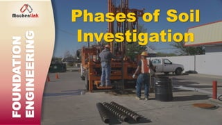
- 7. MachenLink PHASE - II (PRILIMINARY RECONNAISSANCE) Preliminary reconnaissance or a site visit to provide a general picture of the topography and geology of the site. • Photographs of the site and its neighbourhood. • Access to the site for workers and equipment. • Sketches of all fences, utility posts, driveways, walkways, drainage systems, and so on. • Utility services that are available, such as water and electricity. • Sketches of topography including all existing structures, cuts, fills, ground depression, ponds, and so on. • The state of any existing building at the site or nearby. Your notes should include exterior and interior cracks, any noticeable tilt, type of construction, evidence of frost damage, moulds, and any exceptional features. • Geological features from any exposed area such as a road cut. • Occasionally, a few boreholes may be dug to explore the site. Your site visit notes should include the following:
- 8. MachenLink PHASE - III (DETAILED SOIL EXPLORATION) The objectives of a detailed soils exploration are: • To determine the geological structure, which should include the thickness, sequence, and extent of the soil strata. • To determine the groundwater conditions. • To obtain disturbed and undisturbed samples for laboratory tests. • To conduct in situ tests. • The field test may be conducted for determining the in – situ values of density, bearing capacity, shear strength, permeability, and pore pressures.
- 9. MachenLink PHASE - IV (LABORATORY TESTING) • To classify the soils. • To determine • soil strength, • failure stresses and strains, • stress–strain response, • permeability, • compactibility, and • settlement parameters. Not all of these may be required for a project
- 10. MachenLink PHASE - V (WRITE A REPORT) • The report must contain a clear description of the soils at the site, • Methods of exploration, • Soil stratigraphy, • In situ and laboratory test methods and results, and • The location of the groundwater.