Download to read offline
![Dr R.J. (Bob) Williams [Retired]
Cartographer
Topographic Surveyor
Geographer
Geospatial Scientist
QUALIFICATIONS – Professional
BA Computing Studies (Canberra CAE)
MSc (Cartography) (U Wisconsin)
PhD (UNSW)
QUALIFICATIONS – Trade
Topographic Surveyor
Photogrammetrist
Cartographic Technician
Videre Parare Est
An Odyssey
by
DR BOB’S VISION AND ODYSSEY
Towards
A Virtual World and an Intelligent [Artificial] Cartographer
The 1980s … …
A Decade of Innovation … …
… … with Experience and Vision … …
2008 photo](https://image.slidesharecdn.com/rjwodysseythe1980s-161226234808/85/RJW-Odyssey-the-1980s-1-320.jpg)
![Dr R.J. (Bob) Williams [Retired]
Cartographer
Topographic Surveyor
Geographer
Geospatial Scientist
QUALIFICATIONS – Professional
BA Computing Studies (Canberra CAE)
MSc (Cartography) (U Wisconsin)
PhD (UNSW)
QUALIFICATIONS – Trade
Topographic Surveyor
Photogrammetrist
Cartographic Technician
Videre Parare Est
An Odyssey
by
DR BOB’S VISION AND ODYSSEY
Towards
A Virtual World and an Intelligent [Artificial] Cartographer
The 1980s … …
A Decade of Innovation … …
… … with Experience and Vision … …
2008 photo](https://image.slidesharecdn.com/rjwodysseythe1980s-161226234808/75/RJW-Odyssey-the-1980s-1-2048.jpg)
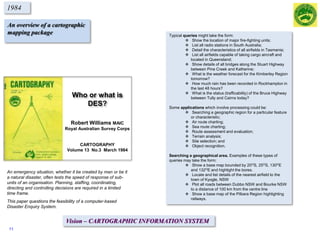
![So, in 1980 I wrote the first draft of a paper titled Who or what is DES?”.
The abstract to the paper reads “an emergency situation, whether it be military in nature or
a natural disaster, often tests the speed of response of sub-units of an organisation.
Planning, staffing, coordinating, directing and controlling decisions are required in a
limited time frame”.
The paper examined the feasibility of developing a computer-based system that I called DES
(Defence Enquiry System).
VISIONARY IDEAS – DES
Types of queries, include:
Show the location of 4 Fd Regt, RAA.
List all airfields capable of taking C130 aircraft and located in 1MD.
What is the status (trafficability) of the Bruce Highway between Tully and Cairns today?
Applications include:
Route charting and assessment (land, maritime and air)
Terrain analysis and site selection
Shortest path algorithms
Imagery, e.g. Orthophotomaps replaced by digital images
Object recognition
It might be feasible that digital terrestrial cameras of the future could be used to identify features.
In December 1976 I was given the opportunity to undertake Long Term
Schooling at the Canberra College of Advanced Education (CCAE) by the
Director of Survey of Survey-Army (COL Jim Stedman). I was asked, on
completion of my course, to write a discussion paper on where I thought the
Royal Australian Survey Corps should be heading by DSVY-A
(COL John Hillier).
This paper was to provide a vision for the future.
Photo taken in December 1979 of [then] SSGT Bob Williams
Military symbols produced using TEKTRONIX PLOT10
software
Following 1970’s decade and hearing and talking to its Visionaries came a decade of opportunity
- A decade of innovation!
This directive, supplemented by exposure to 1970’s visionaries, provided my guidance for the next quarter of a century PLUS !
Towards a Virtual World and an Intelligent [Artificial] Cartographer
CCAE
RASVY
2](https://image.slidesharecdn.com/rjwodysseythe1980s-161226234808/85/RJW-Odyssey-the-1980s-2-320.jpg)
![Visionary presenters
& presentations
Academic theses,
awards, etc
Studies & reviews
& scientific reports
Journal
publications
Conference & seminar
Presentations
Concept papers
& initiatives
1980 1985 1990
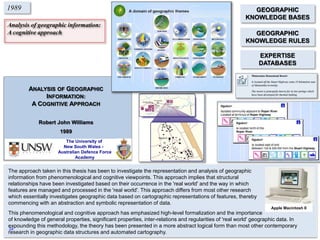
American futurist Ben Bova [1989]
"I don't think of what I do as science fiction, I think of it as
historical reports of events that haven't happened yet”
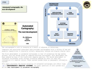
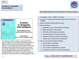
Automated cartography:
the next development
Evolution in cartography:
data intelligence
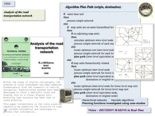
Analysis of the road
transportation network
Geographic information:
aspects of phenomenology and cognition
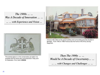
Analysis of Geographic Information:
A cognitive approach
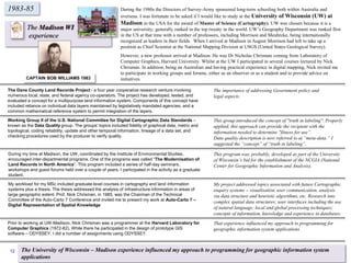
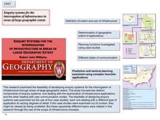
Enquiry systems for the interrogation of
infrastructure in areas of large geographic extent
Who or what is DES?
[Disaster Enquiry System]
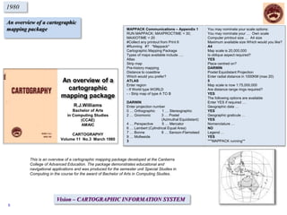
An overview of a cartographic
mapping package
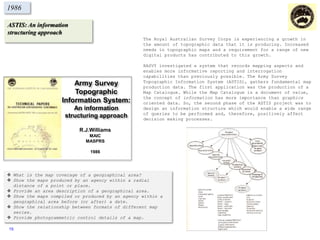
ASTIS: An Information
Structuring Approach
Enquiry systems for the
interrogation of infrastructure
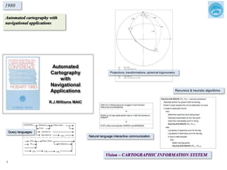
Automated cartography with
navigational applications
Who or what is DES?
1980’s Timeline
YAMPI
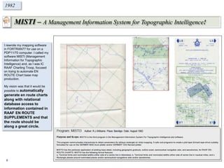
MISTI
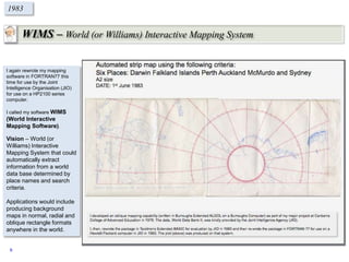
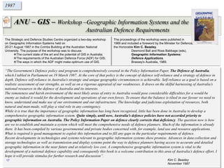
ANU GIS ADFA GISWIMS
3](https://image.slidesharecdn.com/rjwodysseythe1980s-161226234808/85/RJW-Odyssey-the-1980s-3-320.jpg)
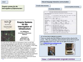
![Who or what is DES?
[Defence Enquiry System]
1980
Typical object recognition enquiries might take the form:
• What is the feature 5KM north-west of the junction of
road A and road B?
• Give details of this building (pointed to on a screen).
• What is this feature (pointed to on a screen)?
Examples of these types of queries may take the form:
• Show a base map bounded by 20OS, 25OS, 130OE and 132OE
and highlight the bores.
• Locate and list details of the nearest airfield to
the town of Kyogle, NSW
• Plot all roads between Dubbo NSW and Bourke NSW to a
distance of 100KM from the centre line
A DEFENCE ENQUIRY SYSTEM (DES)
LT R.J.Williams
1980
The world is moving so fast these
days that the man who says it can’t
be done is generally interrupted by
someone doing it!
Elbert Hubbard
Circa 1890
In December 1976 I was given the
opportunity to undertake Long Term
Schooling at the Canberra College of
Advanced Education (CCAE) by the
Director of Survey-Army (Colonel Jim
Stedman).
I was asked, on completion of my
course, to write a discussion paper
on where I thought that the Corps
should be heading by DSVY-A (Colonel
John Hillier).
This paper is a re-typed copy of the
original paper with scanned copies of
the original illustrations.Photo taken in December 1979 of (then) SSGT Bob
Williams.
Military symbols produced using Tektronix PLOT
10 software.
4](https://image.slidesharecdn.com/rjwodysseythe1980s-161226234808/85/RJW-Odyssey-the-1980s-4-320.jpg)
![YAMPI – A digital mapping experience!
1980
6
3665-III STRICKLAND [1:50000]
was the first map published using
the AUTOMAP I system in 1978.
Compilation was by digital
photogrammetric methods 1976.
YAMPI JOG [1:250000]
The first, and only ever, !;250,000 map -
SE51-3 YAMPI - was produced from source
digital data of the 1:50,000 maps compiled
by stereo-photogrammetric techniques
during June – August 1980.
MAP GENERATION
The YAMPI: A Digital Mapping Experience, described the area; discussed the map production describing the available source data, detailing
production time limitations and method of production; analyzed various aspects observed during the production including the integrity of the data bank,
cost of data manipulation processes, the effect of management and operational procedures and the quality of the graphic; and, finally examined some
future applications and recommendations.
Future applications include:
Command, control &
communication systems
Infrastructure directories
Radar simulation](https://image.slidesharecdn.com/rjwodysseythe1980s-161226234808/85/RJW-Odyssey-the-1980s-6-320.jpg)

This document summarizes the career and work of Dr. Bob Williams from 1980 to the present. It outlines his educational background and qualifications in fields like cartography, surveying, and geospatial science. It then describes several projects he worked on in the 1980s that demonstrated innovative and visionary ideas for automated cartography and geographic information systems. These included early digital mapping software called MAPPACK, YAMPI, MISTI, and WIMS that allowed for automated map generation and querying of geographic databases. The document discusses how these projects foreshadowed future applications in areas like navigation, infrastructure management, and command/control systems.


![Future Defence Geospatial Environment Future [2000]](https://cdn.slidesharecdn.com/ss_thumbnails/futuregeoenv2000-210923064710-thumbnail.jpg?width=640&height=640&fit=bounds)


