Download to read offline
![BACK TO THE FUTURE:
OIESS2025 - Burrows - Rosetta
Dr R.J. (Bob) Williams [Retired]
Cartographer
Topographic Surveyor,
Geographer & Geospatial Scientist
30 Oct – 1 Nov 2018
I don't think of what I do as science fiction,
I think of it as historical reports of events that haven't happened yet!](https://image.slidesharecdn.com/bobwilliamshydro18-presentation-210416053614/85/Back-to-the-Future-OIESS-2025-Burrows-and-Rosetta-1-320.jpg)
![BACK TO THE FUTURE:
OIESS2025 - Burrows - Rosetta
Dr R.J. (Bob) Williams [Retired]
Cartographer
Topographic Surveyor,
Geographer & Geospatial Scientist
30 Oct – 1 Nov 2018
I don't think of what I do as science fiction,
I think of it as historical reports of events that haven't happened yet!](https://image.slidesharecdn.com/bobwilliamshydro18-presentation-210416053614/75/Back-to-the-Future-OIESS-2025-Burrows-and-Rosetta-1-2048.jpg)
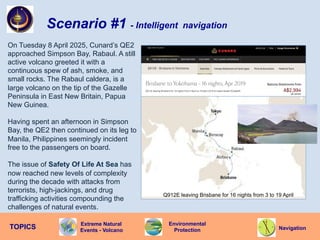
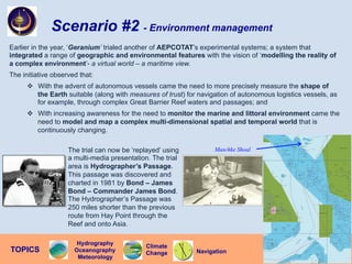
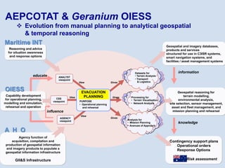
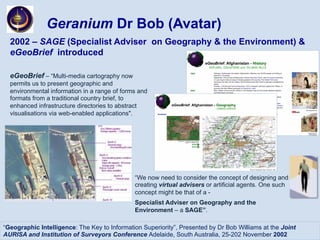
![The Endeavour is the Geranium OIESS’s
deployable asset and has a range of highly
advanced capabilities. These include:
v Cutlass - a ‘drone’ with sensors capable
of measuring gasses and soils that
enable the on-board Incident Response
Cell to determine ‘safety’ for the tourists;
v Flipper - an unmanned underwater
vehicle with a range of sensors to assist
in navigation.
Scenario #1 - Geranium assets
PNT [Position / Navigation / Timing]
Multi-Level Security
OIESS
Contribution
to a
Secure
World
Cutlass has a truly unique capability that is
required for this voyage by QE2. Cyber-terrorists
have disrupted and disabled GPS and,
subsequently, precision navigation using space-
based systems. However, during the preceding
decade hydrographers have modified
existing lighthouses throughout
the archipelago with geodetic
accuracy. Cutlass is then able
to calculate a ‘Q-route’ and
escort/pilot QE2 safely.
Another of Geranium’s assets is access to the
highly classified Oceania Sea Eagle which
monitors maritime traffic of all types as well as on-
shore weapons of terrorist groups.
OIESS Sea Eagle
Cutlass
Endeavour
Flipper](https://image.slidesharecdn.com/bobwilliamshydro18-presentation-210416053614/85/Back-to-the-Future-OIESS-2025-Burrows-and-Rosetta-6-320.jpg)
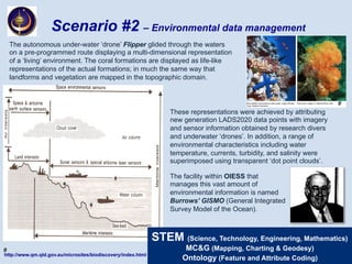
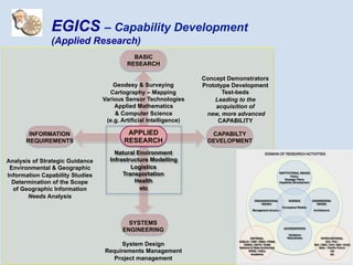
![Geranium OIESS
v A Command Support Infrastructure
Resources
Coordination of:
agency collaboration
emergency services
integrated communications
asset management
Intelligence
Collaboration with:
national security agencies
maritime agencies
aeronautical agencies
emergency management agencies
Higher
Authority
Surveillance &
Monitoring
NOAA photo
Support for:
natural disasters
incidents and events
terrorist activities
illegal fishing
illegal migration
Coordination
Consider OIESS as being within a next-generation
NATIONAL DISASTER ORGANISATION [NDO]
OIESS
Support for:
navigation
terrorist emergencies
maritime search and rescue
multi-agency disaster relief
illegal fishing
illegal immigration
integrated communications](https://image.slidesharecdn.com/bobwilliamshydro18-presentation-210416053614/85/Back-to-the-Future-OIESS-2025-Burrows-and-Rosetta-12-320.jpg)
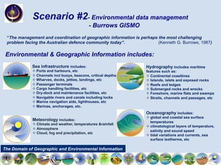
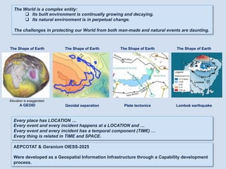
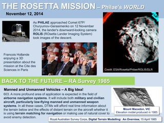
![Can such a ‘paradigm shift’ be made to address 2025 vision and beyond … ?
THE ROSETTA MISSION
November 12, 2014
WELCOME TO A COMET
Photo: ESA
We've turned science fiction into science fact today.
This is a big step for human civilisation
ESA’s Director General Jean-Jacques Dordain
Our ambitious Rosetta mission has secured
another place in the history books
Warwick Holmes told ABC
from the ESA's operations centre in Darmstady, Germany.
BACK TO THE FUTURE – Ben Bova 1989
“I don't think of what I do as science fiction, I think of it as historical reports of events
that haven't happened yet”
Ben Bova# presented the Keynote Address “Welcome to Moonbase’ [2020] to the ASPRS/ACSM/AUTO-
CARTO 9 Conference, Baltimore](https://image.slidesharecdn.com/bobwilliamshydro18-presentation-210416053614/85/Back-to-the-Future-OIESS-2025-Burrows-and-Rosetta-15-320.jpg)
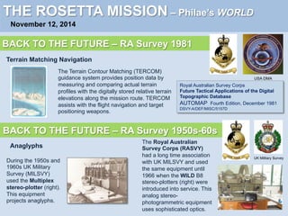
![Under the DCP, RASVY completed many cooperative and collaborative projects with
nations in Australia’s area of strategic interest. These projects included:
v ground surveys, and definition of geodetic datums,
v air photography, and mapping, and charting
v assistance with definition of Exclusive Economic Zones,
v provision of equipment and technology transfer and
v training of officers and technicians.
1970-92
A Proud Heritage-Defence Cooperation Program
Projects commenced in 1970 in Indonesia and expanded over 25 years to include:
v Solomon Islands, Fiji, Tonga, Cook Islands, Kiribati, Nauru, Tuvalu, Vanuatu , Western Samoa.
Technical Advisers were posted to national survey and mapping organisations in:
v Fiji, Indonesia, Malaysia, Papua New Guinea, Solomon Islands and Vanuatu.
All field survey operations outside Australia, and indeed in Australia, would not have been possible without essential
support of most other Army Corps (Engineers; Signals; Aviation [Cessna, Porter, Sioux, Kiowa]; Chaplains; Medical;
Dentist; Transport; Ordnance; Electrical and Mechanical Engineers; Pay; Catering; Service); the Royal Australian Navy
(Hydrographic Service [Landing craft, Patrol boats]); and, at times, the Royal New Zealand Navy
(Hydrographic Service); the Royal Australian Air Force [Canberra, Hercules, Caribou, Iroquois]; and civil charter
fixed wing and helicopters for aerial survey work and transport.
Two members of the Australian Defence Force died on military survey operations in the 1970s in Papua New Guinea
and in Indonesia.
Army Survey’s DCP activity came to an abrupt end in 1995 !](https://image.slidesharecdn.com/bobwilliamshydro18-presentation-210416053614/85/Back-to-the-Future-OIESS-2025-Burrows-and-Rosetta-27-320.jpg)
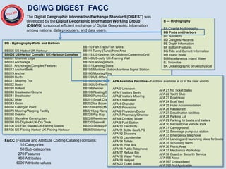
![• Bathymetry / Bottom topography
• Bottom slope
• Bottom morphology (type, trafficability)
• Underwater obstacles and obstructions
• Beaches (composition, slope, obstacles)
• Riverine (width, depth, gradient)
• Land (vegetation, trafficability)
• Q-Routes
• Magnetic
• Miscellaneous (fishing, shipping,
industrial, marine life)
Content
Bottom characteristics
Material composition category
Material composition secondary
Material composition underlying
Physical surface characteristics
BF010
MCC
MCS
MCU
PSC
7 attributes
20 attributes
Obstruction (nautical)
Wreck
BD070
BD180
13 attributes
2 attributes
14 attributes
Route (Maritime)
Swept area
Maritime area
FC165
FC177
FC031
incl MAC Maritime Area Category 80 values
incl Dredged channel
Mine danger area
Anchorage (general)
Oil field
Seal sanctuary
- Littoral Information [Example with DIGEST Features and Attributes]
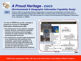
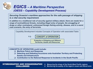
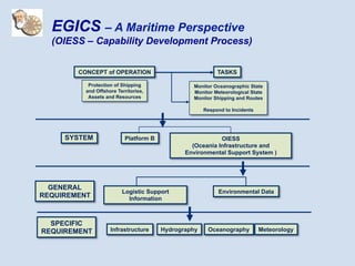
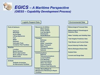
EGICS – A Maritime Perspective
(OIESS – Capability Development Process)](https://image.slidesharecdn.com/bobwilliamshydro18-presentation-210416053614/85/Back-to-the-Future-OIESS-2025-Burrows-and-Rosetta-38-320.jpg)
![Robert (Bob) Williams
BA Comp Stud. (Carto major) - Canberra CAE, MSc (Cartography) – U Wisconsin, PhD – UNSW @ ADFA
Topographic surveyor (trade training), Cartographer and geospatial scientist
One of Australia’s Military Mapmakers
Videre Parare Est
“I would be happy indeed if I could leave this conference feeling that some enthusiasm
has been aroused for broadening the concept of cartography away from the relatively
simple concept of drawing maps. …
When we consider the magnitude of the [environmental] problem, the aspirations for
‘change’, the technological possibilities open to us, and our responsibilities to the people
of our world, I hope that historians will not look back and say that we missed what might
be our greatest (perhaps last) opportunity”.](https://image.slidesharecdn.com/bobwilliamshydro18-presentation-210416053614/85/Back-to-the-Future-OIESS-2025-Burrows-and-Rosetta-43-320.jpg)
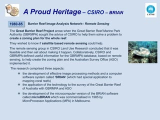
![REFERENCES
Burrows, Kenneth (1989), “Hydrography and the Management of Geographic Information for Defence”, in Geographic
Information Systems: Defence Applications, Desmond Ball and Ross Babbage (eds), Brassey's Australia.
Williams, R.J. (1989). Analysis of Geographic Information: A Cognitive Approach, A thesis submitted for the degree of
Doctor of Philosophy, The University of New South Wales, Australian Defence Force Academy, Canberra
Williams, R.J. (2002). “Geographic Intelligence: The Key to Information Superiority”, Joint AURISA and Institution of
Surveyors Conference Adelaide, South Australia, 25 November.
Williams, R.J. (2011). “Welcome To Te Ika a Maui OIESS 2020” presented at the Spatial Sciences & Surveying Biennial
Conference 2011, Wellington, New Zealand.
QUOTES
James Cook (1774). "I had the ambition to not only go farther than man had gone before, but to go as far as it was possible
to go”. Cook’s Second Voyage.
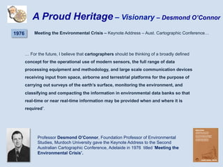
Desmond O’Connor (1976). “For the future, I believe that cartographers should be thinking of a broadly defined concept for
the operational use of modern sensors, the full range of data processing equipment and methodology, and large scale
communication devices receiving input from space, airborne and terrestrial platforms for the purpose of carrying out surveys
of the earth’s surface, monitoring the environment, and classifying and compacting the information in environmental data
banks so that real-time or near real-time information may be provided when and where it is required” gave the Keynote
address titled ‘Meeting the Environmental Crisis’ to the Second Australian Cartographic Conference, Adelaide.
Kenneth G. Burrows (1987) “The management and coordination of geographic information is perhaps the most challenging
problem facing the Australian defence community today”, presented at the Strategic and Defence Studies Centre organised
workshop on Geographic Information Systems (GIS) on 20-21 August 1987 at the Australian National University
Ben Bova (1989). “I don't think of what I do as science fiction, I think of it as historical reports of events that haven't
happened yet”, presented in the Keynote Address “Welcome to Moonbase’ [2020] to the ASPRS/ACSM/AUTO-CARTO 9
Conference, Baltimore.](https://image.slidesharecdn.com/bobwilliamshydro18-presentation-210416053614/85/Back-to-the-Future-OIESS-2025-Burrows-and-Rosetta-45-320.jpg)

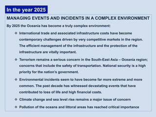
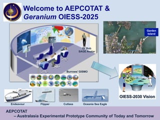
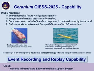
Geranium OIESS is an advanced system for managing events and incidents in Oceania's complex environment by 2025. It facilitates interaction with future navigation systems, integrates natural disaster information, and coordinates incident response. OIESS provides surveillance, navigation support, and environmental protection capabilities through assets like Cutlass and Flipper drones. It also manages vast amounts of geographic and environmental data through systems like Burrows' GISMO to support issues like climate change, security, and infrastructure protection.


![Future Defence Geospatial Environment Future [2000]](https://cdn.slidesharecdn.com/ss_thumbnails/futuregeoenv2000-210923064710-thumbnail.jpg?width=640&height=640&fit=bounds)


