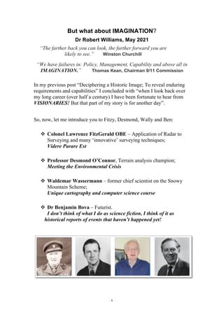
In presenting his report on the 9/11 Commission Report, Thomas Kean stated "We have failures in: Policy, Management, Capability and above in IMAGINATION". This article follows on from my previous post "Deciphering a Historic Image; To reveal enduring requirements and capabilities". So, now, let me introduce you to Fitzy, desmond, Wally and Ben.
My Hydrospatial 21 presentation titled "Back to the Future: The Climate for Change and the Hydrographer of the Future" contained a number of slides noting supplement.
This presentation is the Rosetta link. It suggests that visionary capabilities are possible and uses components of the Rosetta mission with past capabilities.
Galaxy Forum SEA Indonesia - Steve DurstILOAHawaii
"ILOA Galaxy 21st Century Education and Exploration"
ILOA is very pleased to have cooperation and participation in organizing this Galaxy Forum Southeast Asia of Among Putro SKYWORLD Indonesia, which is a private space/aerospace, astronomy and related science/technology educational and recreational institution located on a national semi-governmental cultural conservation, education and recreational park called “Taman Mini Indonesia Indah” (Wonderful Indonesian Miniature Park) in the city of Jakarta.
Galaxy Forum is the primary education and outreach initiative of the International Lunar Observatory Association, an architecture designed to advance 21st Century science, education, enterprise and development.
Galaxy Forums are public events specifically geared towards high school teachers, educators, astronomers of all kinds, students and the general public. Presentations are provided by experts in the fields of astrophysics / galaxy research, space exploration and STEM education, as well as related aspects of culture and traditional knowledge. Interactive panel discussions allow for community participation and integration of local perspectives.
Sixty-five Galaxy Forums with a total of almost 300 presentations have been held in 26 locations worldwide (since Galaxy Forum USA, July 4, 2008) including Hawaii, Silicon Valley, Canada, China, India, Southeast Asia, Japan, Europe, Africa, Chile, Brazil, Kansas and New York.
The theme of Galaxy Forum Japan this year is 21st Century Frontiers of Astronomy and Observation. The event will be held at the NAOJ Large Seminar Room and 4D2U Dome Theater. Seating is on a first come first serve basis (limited to 80 participants). Most of the presentations and discussion will be in Japanese. Here is a link to a local website devoted to the event (http://moonstation.jp/ja/events/Galaxy_Forum/).
ILOA Galaxy Forum SEA Thailand -- Galaxy 21st Century Education, Exploration ...ILOAHawaii
The 4th Regional Galaxy Forum Southeast Asia is taking place at the Science Centre for Education at the Bangkok Planetarium in collaboration between ILOA, National Astronomical Research Institute of Thailand (NARIT) and Geo-Informatics and Space Technology Development Agency (GISTDA).
Thailand is a leader in the region for Astronomy and Satellite Technology.
NARIT is a national research organization for astronomy in Thailand enabling the development of a collaborative research network both regionally and globally, and aiming at developing and strengthening knowledge in astronomy at an international level. They also ally with public and private observatories and other institutions around the World to pursue excellence in scientific research, education and public outreach.
Hydrospatial 21 [Education] - Dr Bob Williams
My presentation at Hydrospatial 21 at Cairns in February 2022 was titled "Back to the Future: The Climate for Change and the Hydrographer of the Future". It referred to supplementary information in other presentations.
This supplementary presentation describes "Education" and related topics; a personal experience
EDUCATION is the process of facilitating learning, or the acquisition of knowledge, skills and personal development and should be an enlightening experience.
My reflection is the the Mid-70s to Mid-80s were Enlightening years. This presentation describes my activities for that timeline including studies at the Canberra College of Education
A personal experience by Dr Bob Williams 1983-88 with lead up to MSc (Cartography) studies at the University of Wisconsin - Madison. This is followed by initiatives including conferences.
Towards a Virtual World and an Intelligent [Artificial] Cartographer
Post-graduate education should be more than attending set courses and doing a final year project. It should be about undertaking activities and a major project that challenges current practice. It should be an experience that contributes to a science offering innovative thought and a vision for the future.
This document tells my experience for MSc (Cartography) at the University of Wisconsin in the mid-1980s including events before and after.
Cartography is a communication system and should be a fundamental infrastructure required to meet the information demands of contemporary challenges.
"""Preface to Challenges of Space Anthropology"" Challenges of Space Anthropo...ISAS_Director_Tsuneta
"""Preface to Challenges of Space Anthropology""
Challenges of Space Anthropology 2014-2015, 2015-03-27, JAXA Research and Development Memorandum NO:JAXA-RM-14-012E"
Imagination innovation space explorationPeter Pappas
An interactive DBQ by Mollie Pettit explores the question: What is the relationship between imagination and innovation within the context of space travel? A chapter excerpt from Exploring History Vol IV. http://bit.ly/2iyHMaX
Dare to Change 1980Reflections of one of Australia's Military MapmakersRobert (Bob) Williams
It was 40+ years ago!
Reflections of One of Australia’s Military Mapmakers
(SPR / CPL / SGT / SSGT / LT / CAPT / MAJ / DR)
Robert (Bob) Williams
Cartographic Information Systems – DES and MAPPACK:
Then wait; there’s more!
This is an overview of a cartographic mapping package developed at the Canberra College of Advanced Education. The package demonstrates educational and navigational applications and was produced for the semester unit Special Studies in Computing in the course for the award of Bachelor of Arts in Computing Studies.
It was 20 years ago!
Dare to Change - Geographic Intelligence – The Key to Information Superiority
Request for assistance:
“I’ve lined up CDF (Chief of the Defence Force) to give a luncheon talk to the members of ASIBA (Australasia Spatial Information Business Association) on Thursday 10 October. Naturally I will have to write his speech! If you have any particular thoughts on what I might include, I would be grateful. The aim will be to give the spatial industry lobby a feeling that Defence recognises, values and needs quality geo information in many areas.
As well, I’ve agreed to speak to AURISA (Australasian Urban and Regional Information Association) on November 27 – guest / keynote speaker I think. Again any ideas you might want to proffer would be welcome”.
[Director, DIGO]
Geospatial Intelligence in Support of the Australian Approach to WarfareRobert (Bob) Williams
This paper (written in 2003) introduces the term geospatial intelligence to the lexicon of Australia’s national security. The paper describes a framework of concepts as they apply to imagery, imagery intelligence, and geographic, infrastructure and environmental information, referred to collectively as Geospatial Intelligence. The paper also describes the means of acquiring, processing and disseminating the range of products and services to the Defence community, referred to as Geospatial Information Infrastructure.
The article linked to (below) is somewhat of an odyssey. It commences with discussion on, possibly, the first land information system in Australia and my association with it - Eurobodalla.
It then briefly describes follow on applications including a military terrain-mapping product. Subsequent products cover the littoral zone for beach landings. So, it could be described as terrain intelligence.
This idea stemmed from the D-Day invasion maps (Benson and Bigot).
And, so, follows the Benson and Bigot story – an amazing cartographic accomplishment. To view a video of this stunning activity view the link at the end of the article
The article linked to (below) is somewhat of an odyssey. It commences with discussion on, possibly, the first land information system in Australia and my association with it - Eurobodalla.
It then briefly describes follow on applications including a military terrain-mapping product. Subsequent products cover the littoral zone for beach landings. So, it could be described as terrain intelligence.
This idea stemmed from the D-Day invasion maps (Benson and Bigot).
And, so, follows the Benson and Bigot story – an amazing cartographic accomplishment. To view a video of this stunning activity view the link at the end of the article.
Hydrospatial 21 [Policy] - Dr Bob Williams
My presentation at Hydrospatial 21 at Cairns in February 2022 was titled "Back to the Future: The Climate for Change and the Hydrographer of the Future". It referred to supplementary information in other presentations.
This supplementary presentation describes "Policy" and related topics.
POLICY is a deliberate system of guidelines to guide decisions and achieve rational outcomes. A policy is a statement of intent and is implemented as capability development.
My Hydrospatial 21 presentation titled "Back to the Future: The Climate for Change and the Hydrographer of the Future" contained a number of slides noting supplement.
This presentation is the Capability Development link. CAPABILITY is defined as the capacity to achieve a specific effect, in a nominated operating environment or location, within a specific degree of notice, and to sustain that effect for a given time. CAPABILITY has as its components: personnel; education and training; equipment; organisation; structure; deployment; preparedness; and doctrine
Back to the Future: The Climate for Change and the Hydrographer of the FutureRobert (Bob) Williams
This presentation was given at Hydrospatial 2021 held in February 2022 at Cairns, Queensland. The presentation looks at capability of the futuristic Oceania Infrastructure and Environmental Support System.
A presentation to supplement a presentation titled "Back to the Future: The Climate for Change and the Hydrographer of the Future" given at Hydrospatial21 held in cairns February 2022
Research and development project proposal written in december 1994. The purpose was to offer a strategy and a commitment to an evolutionary approach in the development of a system to provide Regional Geospatial Information and service.
Geographic intelligence. This presentation was developed in 2000-2001 in response to a question from a senior military officer who asked "how much geographic information do I need and what can go wrong if I haven't got it"!
Digital transformation and the concept of a 'virtual world' was a topic of interest in the 1990s. The Australian Defence Organisation conducted a number of major capability studies in the mid 1990s including the Environmental and Geographic Information Capability Study. Following on from that I presented this presentation.
eGeoBrief - Afghanistan - Facilities
The Facilities presentation was produced in October 2001.
The overall eGeoBrief has presentations for History, Geography, Politics, Communications, Facilities, Resources, Economy and Envronment.
CAUTION:
Information contained in this product has been compiled from a range of sources from the Internet.
Information has NOT been independently validated.
This product has been developed as a ‘proof of concept’ for electronic geographic briefs (eGeoBrief)
There are moments in one’s career that, in retrospect, hold significance. The 24th August 2001 is one of those days – 20 years ago today.
On 23rd August I travelled from Adelaide to Canberra and gave a number of presentations on my recent overseas trip on 24 August 2001.
In this document I introduce two audacious initiatives: Aeronatical Intelligence and eGeoBriefs (via an avatar).
Twenty years ago various organisations and professional bodies were developing leading edge capability in geospatial infrastructures. This presentation following an overseas visit was given to various groups in Canberra on 24 August 2001.
This is a story of an amazing military mapping organisation and its iconic home - Fortuna Villa, Bendigo. The document include many photographs, figures, and descriptions.
This paper takes us on a journey by deciphering the image to identify nationally important capabilities and to present day challenges focusing on Safeguarding a Nation from contemporary threats.
0x01 - Newton's Third Law: Static vs. Dynamic AbusersOWASP Beja
f you offer a service on the web, odds are that someone will abuse it. Be it an API, a SaaS, a PaaS, or even a static website, someone somewhere will try to figure out a way to use it to their own needs. In this talk we'll compare measures that are effective against static attackers and how to battle a dynamic attacker who adapts to your counter-measures.
About the Speaker
===============
Diogo Sousa, Engineering Manager @ Canonical
An opinionated individual with an interest in cryptography and its intersection with secure software development.
Acorn Recovery: Restore IT infra within minutesIP ServerOne
Introducing Acorn Recovery as a Service, a simple, fast, and secure managed disaster recovery (DRaaS) by IP ServerOne. A DR solution that helps restore your IT infra within minutes.
Sharpen existing tools or get a new toolbox? Contemporary cluster initiatives...Orkestra
UIIN Conference, Madrid, 27-29 May 2024
James Wilson, Orkestra and Deusto Business School
Emily Wise, Lund University
Madeline Smith, The Glasgow School of Art
Have you ever wondered how search works while visiting an e-commerce site, internal website, or searching through other types of online resources? Look no further than this informative session on the ways that taxonomies help end-users navigate the internet! Hear from taxonomists and other information professionals who have first-hand experience creating and working with taxonomies that aid in navigation, search, and discovery across a range of disciplines.
This presentation by Morris Kleiner (University of Minnesota), was made during the discussion “Competition and Regulation in Professions and Occupations” held at the Working Party No. 2 on Competition and Regulation on 10 June 2024. More papers and presentations on the topic can be found out at oe.cd/crps.
This presentation was uploaded with the author’s consent.
Competition and Regulation in Professional Services – KLEINER – June 2024 OEC...
But what about IMAGINATION?
1. 1
But what about IMAGINATION?
Dr Robert Williams, May 2021
“The farther back you can look, the farther forward you are
likely to see.” Winston Churchill
“We have failures in: Policy, Management, Capability and above all in
IMAGINATION.” Thomas Kean, Chairman 9/11 Commission
In my previous post “Deciphering a Historic Image; To reveal enduring
requirements and capabilities” I concluded with “when I look back over
my long career (over half a century) I have been fortunate to hear from
VISIONARIES! But that part of my story is for another day”.
So, now, let me introduce you to Fitzy, Desmond, Wally and Ben:
v Colonel Lawrence FitzGerald OBE – Application of Radar to
Surveying and many ‘innovative’ surveying techniques;
Videre Parare Est
v Professor Desmond O’Connor, Terrain analysis champion;
Meeting the Environmental Crisis
v Waldemar Wassermann – former chief scientist on the Snowy
Mountain Scheme;
Unique cartography and computer science course
v Dr Benjamin Bova – Futurist.
I don’t think of what I do as science fiction, I think of it as
historical reports of events that haven’t happened yet!
2. 2
Colonel Lawrence FitzGerald (Fitzy) was the longest
serving Director of the Army Survey Corps [Jun 1942-
Jan 1960]. I remember that on 1 July 1975 he
addressed members of the Army Survey Regiment at
Bendigo. He spoke about our history.
The Royal Australian Survey Corps was established in
1915 (ten weeks after Gallipoli). RASVY was dis-
established in 1996.
Innovation. In 1946 FitzGerald explained to the Congress of the Australian
and New Zealand Association for the Advancement of Science held in
Adelaide in 1946, considerable interest was being taken in recent
developments in the application of RADAR to surveying.
The surveying and mapping of Australia and the South West Pacific islands
demanded innovation including electronic distance measurement (EDM),
airborne EDM, ship-shore triangulation and astronomical surveying.
The third of my topographic trade training courses (1970) included a project to
undertake a 2nd
order 200KM trigonometrical survey from Mount Benambra,
Victoria to Oaklands (north of Corowa), NSW along the Murray River. The
survey required observing two La Place Stations. A La Place station is a
geodetic station at which coincident triangulation and astronomic longitude
and azimuth determinations are made. Our chronometer timing was set by
WWVH. (WWVH is the call-sign of the U.S. National Institute of Standards
and Technology’s shortwave radio time signal station in Kekaha, on the island
of Kauai in the state of Hawaii.) I have included this activity as it shows how
advanced our trade training was in the 1960s. Thanks to Fitzy.
Professor Desmond O’Connor
Desmond O’Connor resigned from his position of Senior
Lecturer in Civil Engineering UNSW in 1963 to serve as
Associate Director, then Director, at the US Army
Engineer Topographic Laboratories Research Institute.
Before taking up his position at Murdoch University in
1973 Desmond O’Connor was Chief, Environmental
Sciences Division, US Army Research Office.
Professor O’Connor gave the Keynote Address to the Second Australian
Cartographic Conference held in Adelaide in 1976. It was titled “Meeting the
3. 3
Environmental Crisis”.
“It is particularly important that Australia develop a capability in this field
because large gaps exist in our knowledge of our own environmental and
natural resources. ...
... For the future, I believe that cartographers should be thinking of a broadly
defined concept for the operational use of modern sensors, the full range of
data processing equipment and methodology, and large scale communication
devices receiving input from space, airborne and terrestrial platforms for the
purpose of carrying out surveys of the earth’s surface, monitoring the
environment, and classifying and compacting the information in environmental
data banks so that real-time or near real-time information may be provided
when and where it is required”.
Waldemar (Wally) Wassermann
Wally retired in 1988 from the School of Applied Science,
Canberra College of Advanced Education. Wally was
appointed as Senior Lecturer in Cartography in 1972
following work at the Geodetic Research Institute,
Frankfurt, where he had been engaged in the application
of satellite imagery to computer mapping. He had
worked previously in Australia as the Chief Surveyor of
the Snowy Mountains Authority.
Wally set up a cartographer major that stressed techniques of computer
mapping and photogrammetry. He also established a program leading to a
three-year bachelor’s degree in surveying.
Three others and I were ‘mature age’ students with surveying and mapping
experience. Wally awarded us exemption from introductory surveying and
cartography subjects. As such we were able to partake in a unique course
combining cartography and computer science. We did a unit in remote
sensory mapping (now known as remote sensing), a unit in machine
intelligence (now known as artificial intelligence), a unit in operations
research, as well analytical cartography units having advanced calculus and
spherical trigonometry.
Benjamin (Ben) Bova
Former President Emeritus of the National Space
Society and a past president of Science Fiction Writers
of America, Dr. Bova received the Lifetime Achievement
Award of the Arthur C. Clarke Foundation in 2005, "for
fueling mankind's imagination regarding the wonders of
outer space.”
Ben gave the Keynote Address at the ASPRS/ACSM/ Auto-Carto 9
4. 4
Conference at Baltimore in 1989. His address (and multi-media presentation)
was titled “Welcome to Moonbase [2020]”.
Abstract. “With the premise that man returns to the moon in 1999 and
establishes a permanent base there by 2020, science fiction author and editor
Ben Bova fashions an intriguing ``manual'' for pioneers arriving at the lunar
community. With 50 detailed illustrations by NASA artist Rawlings, the
guidebook covers Moonbase history, architecture, ecology, transportation,
science projects, jobs, training, industries, tourism, sports (``lunar jai alai''),
entertainment, day-to-day life, duties, rights and laws. Combining fact and
fiction in this ``future history,'' Bova presents a compelling and persuasive
argument for mankind's continual exploration of the moon and the
establishment of a base on the lunar surface”.
I presented a paper in the Spatial Relations and Data Base Models in the
Auto-Carto 9 stream. The moderator was Dr Donna Peuquet, Penn State. The
paper was titled “Geographic Information: Aspects of Phenomenology
and Cognition”.
That conference was truly memorable made more so by Dr Bova’s opening
statement:
I don’t think of what I do as science fiction, I think of it as historical
reports of events that haven’t happened yet!
Sadly, Ben Bova died on November 29, 2020.
So, with a career starting in the 1960s [a decade of true technological
change in surveying and mapping] followed by attendance at my first
major Cartography conference where I experienced a memorable address
titled “Meeting the Environmental Crisis” (Professor Desmond
O’Connor), I commenced my tertiary education with an eminent scientist
and educator who arranged a truly unique course which combined
Cartography with Computer Science (Waldemar Wassermann).
I was fortunate to be able to follow up with post-graduate studies at the
University of Wisconsin – Madison and addressing a scientific discipline
as “Cartography: A Communication Infrastructure”.
A third period of tertiary education, at UNSW@ADFA, allowed me to
write my thesis titled “Analysis of Geographic Information: A
Cognitive Approach”. I presented a paper at the Auto-Carto 9
conference at Baltimore. I found Ben Bova’s address visionary.
5. 5
For the next three decades I have attempted to provide a visionary aspect
to my activities; initially with a “from maps and charts to a virtual
world” style and then a “back to the future” style.
I first used the back to the future style at the Spatial Sciences and
Surveying Biennial Conference 2011 held in Wellington, New Zealand.
The presentation was titled “Welcome To Te Ika a Maui OIESS 2020”.
I introduced my vision of AEPCOTAT. AEPCOTAT stands for Aotearoa
Experimental Prototype Community of Today and Tomorrow [adapted
from Disney’s EPCOT at Disney World]. Adjoining AEPCOTAT is the
visionary system the Te Ika a Maui Oceania Infrastructure and
Environmental Support System (OIESS). It is the OIESS that will enable
a new era and AEPCOTAT that will prototype some of the new concepts
initiated in the laboratories.
I used two scenarios set in the year 2020;
v an aircraft high-jacking similar to 911 incident. My view was that
by 2020 we should have addressed air traffic management and a
‘new black box’ that enables an aircraft to become an autonomous
vehicle with pre-planned abort options; and
v a fire requiring autonomous vehicle.
Since 2011 there have been several air incidents including
MH370. Hence the scenario remains unachieved.
Since 2011 we have witnessed numerous natural disasters
including Black Summer. It seems that maps (and digital
copies of maps) seem to be the norm rather than decision
support systems within a Geospatial Information
Infrastructure.
[See below for links to presentation and paper].
My only opportunity to give a back to the future style presentation to a
national conference in Australia was as a Keynote speaker to the
International Hydrographic HYDRO18 conference held in Sydney in
2018. The paper and presentation was titled “Back to the Future:
OIESS2025, Burrows and Rosetta”.
6. 6
Abstract. “The beginning of this century has witnessed an array of natural
and man-made incidents and events that seriously challenged many
nations’ abilities to predict, respond, recover and progress from the
effects of tragic events. There have been three serious shipping incidents
in our region; the MV Pasha Bulker running aground at Newcastle, the
MV Shen Neng 1 grounding on the Great Barrier Reef, and the MV Rena
running aground on the Astrolabe Reef, New Zealand. In addition there
have been incidents having political consequences such as the incident on
the Shaţţ Al ’Arab waterway. All have all stressed nations’ response
capabilities.
The year is now 2025 and most nations are still struggling to respond any
better to incidents than they were at the beginning of the century. The
exception is the Geranium Oceania Infrastructure and Environmental
Support System (OIESS).
The Geranium OIESS evolved throughout this decade to lead the world
in sophisticated monitoring, strategic and operational planning,
commanding and controlling a range of manned and autonomous vehicles
and assets, and providing maritime intelligence and informed advice to
key authorities.
7. 7
This presentation focuses on maritime incidents and takes us on an
odyssey; reviewing past initiatives, discussing a capability development
strategy and predicting future capabilities. The odyssey reveals the
enduring nature of the engineering characteristics of surveying and
charting and the sciences of geodesy and cartography”.
Scenario [incident] #1 reports on a cruise in the year 2025. It includes the
topic of intelligent navigation and Geranium assets.
“On Tuesday 8 April 2025, Cunard’s QE2 approached Simpson Bay,
Rabaul. A still active volcano greeted it with a continuous spew of ash,
smoke, and small rocks. The Rabaul caldera, is a large volcano on the tip
of the Gazelle Peninsula in East New Britain, Papua New Guinea.
Having spent an afternoon in Simpson Bay, the QE2 then continued on its
leg to Manila, Philippines seemingly incident free to the passengers on
board.
The issue of Safety Of Life At Sea has now reached new levels of
complexity during the decade with attacks from terrorists, high-jackings,
and drug trafficking activities compounding the challenges of natural
events”.
[Slides 5 and 6 in link below]
OIESS assets including Endeavour, Cutlass and Flipper are all
autonomous assets.
The Back to the Future aspect compares capabilities with the European
Space Agency’s Rosetta Mission. The Rosetta mission was approved in
November 1993 as the Planetary Cornerstone Mission in ESA's long-
term space science programme.
8. 8
I use 6 slides to show comparisons using Philae’s world, Ptolemy’s
world, OSIRIS and Rosetta and Philae.
[Slides 17 and 18 in link below]
The White Island (Whakaari) volcano in the Bay of Plenty,
New Zealand had been showing signs of unrest for several
weeks before the 2019 eruption. In October 2019, volcanic
tremors and sulphur dioxide gas were at their highest levels
since 2016, indicating that an eruption was more likely to
occur and on 18 November, the volcano was rated at Volcanic
Alert Level 2, indicating "moderate to heightened volcanic
unrest", due to increased activity.
The volcano erupted on 9 December 2019. There were 47
people on the island at the time. Of these people, 38 were
passengers on a shore excursion from the cruise ship Ovation
of the Seas. 22 died.
So, what has this discussion about visionaries and back to the future style
of presentation to do with addressing capability development demanded
by contemporary challenges in Safeguarding Australia?
In addition to the topics related to Contemporary Threats to Security there
are requirements requiring space-based technology initiatives
[https://www.industry.gov.au/policies-and-initiatives/australian-space-
agency]?
9. 9
There are so many groups, such as CRCs and research groups and private
companies, lobbying for resources and access to contemporary initiatives
related to “space”. As an example, we see terms such as “Space and
Spatial”. Many of these groups have staff with weaknesses in specialist
disciplines. In addition we see considerable ‘hype’ with ‘great
expectations’.
So, I believe that we need to promote established disciplines and
professions and develop Centre of Excellence (say, within existing
universities) and Experimental Prototype facilities within existing
organisations.
We need ‘visionaries’.
We need to acknowledge that Science is important.
We need to acknowledge that Technology is important.
We need to acknowledge that Engineering is important.
We need to acknowledge that Mathematics is important.
Links:
Welcome To Te Ika a Maui OIESS 2020
https://www.slideshare.net/RobertBobWilliams/welcome-to-te-ika-
a-maui-oiess-2020
HYDRO18 Conference - BACK TO THE FUTURE: OIESS2025,
Burrows and Rosetta
https://www.slideshare.net/RobertBobWilliams/back-to-the-future-
oiess-2025-burrows-and-rosetta-246306181