SlideShare a Scribd company logo
1 of 14
Download to read offline
1	
DECIPHERING A HISTORIC IMAGE
– To Reveal Enduring Requirements and Capabilities -
Dr Robert Williams, April 2021
“The farther back you can look, the farther forward you are
likely to see.” Winston Churchill
	
	
In a recent post titled “Image interpretation” I attached a historic photo. I
expressed interest to see how well it would be analysed. I offered a
cryptic clue - Peter Kinne FSSSI. I asked if there were any GEOINT or
'spatial' experts with answers as to what are the key features and where
are they located.
There were no responses.
So, with the clue being Peter Kinne FSSSI there needs to be a ‘location’
connection. There is one entry in his Experience and Education entries on
his LINKEDIN home page that provides the clue. It is Iona College,
Brisbane.
The Google Maps clip shows Iona College, Wynnum North (or Lindum)
at the bottom. Directly north, on the south bank of the Brisbane River,
near the mouth, is Fort Lytton.
The historic photo was taken in 1963.
2	
Google map with annotation
https://www.flickr.com/photos/queenslandstatearchives/27195840409/in/
photostream/
3	
Looking back from the Fort the suburban area is Wynnum North (on left).
The hill on the horizon is probably Mt Petrie.
Fort Lytton defended Brisbane continuously from colonial times until
after World War 2.
The historic fort consists of about a hectare of colonial buildings, tunnels
and other fortified structures embedded in a protective earth-mound wall
and surrounded by a 10m-wide water-filled moat.
Fort Lytton's role in the Second World War was very different from
previous times. It was now part of a much larger defence system.
Between 1937 and 1943, four more coastal forts were built to defend
Moreton Bay. These forts provided the outer defence to prevent enemy
vessels from reaching the mouth of the Brisbane River, while Fort Lytton
provided the inner defence.
Many other defence activities were based at Fort Lytton including a
signals station, a radar station and a heavy anti-aircraft battery. Brisbane's
defences were progressively strengthened during WW2, in line with
Brisbane's increasing strategic significance to the war effort. In particular,
by 1943, Brisbane was a major submarine base. A total of 89 submarines
were dry docked for repairs in Brisbane over a three-year period.
Over 17,000 Australians served in the Korean War between 1950 and
1953. Fort Lytton’s signal station provided essential communications
between Australian and its forces in Korea. The signal station was
significantly upgraded at this stage, including upgrades to radio
equipment, masts and aerials (antennas).
An enduring requirement – Defending our Nation!
Intelligence, surveillance, and command and control are essential
capabilities and need to be complemented by mapping programs.
For example, in February 1539 at Cromwell’s instigation, the King Henry
VIII commissioned certain -
“sadde [mature and trustworthy] and expert men of every shire
in Ingland beyng nere the see . . . to viewe all the places
alongest the secost wher any danger of invasions ys like to be
and to certifie the sayd daungers and also best advises for the
fortificacion therof”.
4	
Returning to the historic 1963 photograph, looking south from the Fort
there is a group of buildings. These buildings are the remains of the
Lytton Quarantine Station.
The Lytton Quarantine Station was established in 1913-1914, to
accommodate newly arrived immigrants and persons considered
being at risk of causing infection to the general population. Situated at
an isolated location at the mouth of the Brisbane River the place
illustrates early 20th century attitudes to quarantine practices and the
provision of quarantine facilities.
At various times the quarantine station buildings also provided
accommodation for persons stationed at adjacent Fort Lytton. The fort
also played a role in the function of the quarantine station, controlling
ships attempting to enter the Brisbane River without appropriate health
clearances. In 1919 the worldwide outbreak of Spanish Influenza which
followed the end of the First World War was delayed in Brisbane by
some three months, following a strict quarantine at Lytton of personnel
returning on troop ships.
5	
By 1928, the Lytton Quarantine Station facilities had been extended and
enhanced. Vessels were met at the river mouth by the Health Authorities
who boarded each ship and inspected all goods and personnel on board.
Suspect people and goods were landed at Lytton for fumigation and
isolation. Jetty facilities permitted passengers to disembark on foot and a
crane was provided for conveying sick passengers, luggage and stores to
shore. A tramline ran from the jetty to the reception house.
6	
The Lytton facility functioned as a human quarantine station until the
early 1980s. In 1982 the Lytton facility reverted to its earlier role as an
animal quarantine station, re-designated the Lytton Quarantine Complex
and Animal Detention Centre. Facilities comprised a launch jetty,
workshop, inflammable store, guinea pig area, imports treatment
laboratory, utility buildings area, offices, stores, and animal quarantine
detention facilities.
In addition to its role as an animal quarantine centre, Lytton served as a
communications centre, a base for south side shipping clearance and
inspection, a facility for dealing with quarantine treatment and detention
of materials, a training area and a depot for stores.
By the late 1980s the Lytton facility had closed completely.
An enduring requirement – Safeguarding our Nation!
Intelligence, surveillance, and reconnaissance; command, control and
communications; targeting and assets employment; navigation and
guidance; mobility and manoeuvre; and health and survival are essential
capabilities in Safeguarding our Nation and need to be complemented by
a Geographic Information Infrastructure. Contemporary threats to our
Nation’s security include Pandemic diseases.
7	
COVID-19 is the disease caused by a new coronavirus
called SARS-CoV-2. The World Health Organization
declared the outbreak a Public Health Emergency of
International Concern on 30 January 2020, and a
pandemic on 11 March 2020.
	
	
There have, of course, been plagues throughout history including the
Black Death and the Great Plague of London.
8	
Major events, such as epidemics and disasters, often result in innovative
techniques to model phenomena. One such example was the use of
geographic and cartographic methods.
1854 London Cholera
outbreak
Possibly the earliest use of
the geographic method
was in 1854 when John
Snow depicted a cholera
outbreak in London
using points to represent
the locations of some
individual cases. His study
of the distribution of
cholera led to the source
of the disease, a
contaminated water pump
within the heart of the
cholera outbreak.
While the basic elements of topology and theme existed previously in
cartography, the John Snow map was unique, using cartographic methods,
not only to depict but also to analyse clusters of geographically dependent
phenomena for the first time.
Map: E.W. Gilbert's version (1958) of John Snow’s 1855 map of the Soho cholera outbreak
showing the clusters of cholera cases in the London epidemic of 1854
A MATTER OF AN URGENT AND PRESSING NATURE
Surely, COVID 19 must be considered as a Global Disaster that deserves
reviews by nations on the way we ‘manage the health and well-being’ of
our peoples - Safeguarding our Nation. We need to undertake a ‘major
capability review’ – an Environmental and Geographic Information
Capability Study.
The world was unprepared for such an event.
Back in 2001, another ‘significant’ event occurred in the USA. The event
is often just referred to as ‘911’. The Report by the 911 Commission
observed:
“NORAD and the FAA were unprepared for the type of attacks
launched against the United States on September 11, 2001. They
struggled under very difficult circumstances to improvise the
homeland defense against a challenge that they had never
9	
encountered, and honestly never been trained to meet.”
The Chairman also noted that:
“We have failures in: POLICY, MANAGEMENT, CAPABILITY,
and above all in IMAGINATION”.
Surely, this list of ‘failures’ can be applied to the pandemic response.
At this point, I could embark on discussion of a range of issues but I have
already posted opinion papers including “Something	Happened	at	
Dayton,	Ohio	-	A	Butterfly	Flapped	its	Wings	-	And	a	Nation	Burns”	[An	
Opinion	by	Dr	Robert	Williams,	January	2020].	
In	my	opinion,	the	first	topic	[POLICY]	is	critically	important.	On	11	
March	2020	the	World	Health	Organisation	declared	the	outbreak	a	
pandemic.	At	that	time	the	Federal	Government	should	have	invoked	
a	National	Emergency	thereby	activating	a	National	Disaster	
Organisation	with	a	Command	Support	Infrastructure	within	a	
National	Mapping	Agency.
10	
But, we don’t have a specialist, dedicated National Mapping Agency nor
a specialist, and dedicated National Disaster Organisation. And, in my
observation, have a critical lack in expertise, skills and nationally
recognised formally qualified staff in the agencies.
An example noting the lack of appropriately qualified experts was
commented on by former US DCI in 2004 as “when asked last fall about
pending intelligence reform, former Director of Central Intelligence
George Tenet said he felt like a patient on an operating table who, while
being prepared for brain surgery, found himself surrounded by 12
surgeons, NON of whom had gone to medical school”.
Just a cursory examination of the formal qualifications of executive level
officers in key agencies reveals awards including Bachelor of Arts
degrees (English; French Language and Literature; Asian Studies;
Biology; etc); Bachelor of Science (Forestry; Zoology; Environmental
Management; etc); Bachelor of Physics; Bachelor of Electrical
Engineering; Bachelor of Mechanical Engineering; Bachelor of
Economics and MBAs.
Where are the experts – the geodesy and cartography scientists and the
surveying and mapping professionals?
Of course, appropriate qualifications and training are not the only
concerns.
There are many topics that need analyzing but as I have used the term
Safeguarding our Nation I will follow that stream focusing on
conferences and symposiums.
In 2002, the Prime Minister of Australia announced Australia’s National
Research Priorities. These were:
• An Environmentally Sustainable Australia,
• Promoting and Maintaining Good Health
• Frontier Technologies for Building and Transforming
Australian Industries and
• Safeguarding Australia.
11	
In 2002 the first of a series of Homeland Security Conferences was held
in Canberra. The fourth in the series was titled Safeguarding Australia
2005. Day 3 included a (SET Science, Engineering and Technology)
Summit and was led by the Honourable Gary Nairn MP, Special Minister
of State.
The first of a series titled Spatially Enabled Government followed,
commencing in 2007.
	
	
Hon Gary Nairn MP, Special Minister
of State
‘Promoting the Australian
Government Spatial Agenda’
14 August 2007
	
“Given my background as a surveyor, it has also been an ideal opportunity to
champion the use of spatial technology and information in Government – to
drive the Australian Government to become more spatially enabled. It is clear
that adding a spatial dimension to data will lead to better decisions – providing
the right services at the right time at the right place”.
2007 Policy and Decision Making to Manage, Extend, Plan and Deliver on
Spatial Capability
2008 Policy to End User – Maximising the Value of Geospatial Data in
Government to Enhance Service Delivery and Evidence Based Policy
2009 Technical and Decision Making for Mapping the Future of
Interoperability, Data Collection & Data Management, For Operational
Excellence within Australian Government
	
Then followed a focused series titled Spatial@Gov.


Location as an
Enabler for Government Business
	
2009 Building Spatial Capability For Government
The Conference program addressed the rapidly increasing demand for
information on how location can be used as an enabler to support
governments at all levels to inform their policy development, enhance
service delivery and gain efficiencies in internal business processes.
2010 Aligning The Spatial Capabilities Of The Three Tiers Of
Government
The spatial@gov® conference was a collaborative initiative of the key
organisations representing the public, commercial, research, education
12	
and professional sectors of the spatial community in Australia and New
Zealand.	
2011 Spatial@Gov2011
Conference themes included:
• Water Security
• Spatial@Defence
• Government Spatial Activities in Other Countries
• Access to Government Spatial Information
• Emergency Response
• The Spatial Framework for Virtual Australia
2012 Future Directions: Linking People, Policy and Place
The conference program addressed two broad categories:
• The Strategy theme explored the policy settings required to ensure
that Governments can best use location-based business intelligence
in support of better informed policy and planning decisions, and
more efficient targeted service delivery to Australian and New
Zealand citizens.
• The Innovation theme looked closely at emerging and future trends
and how Governments might work with the commercial and research
sectors in order to drive future innovation in the Australian and New
Zealand Spatial Community and globally.
At the 2012 Spatial@Gov conference the Assistant Secretary of Spatial
Policy at the Department of Communication announced, what was
described as, “a unification of the spatial industry”.
“Locate was the first step to unify the Australasian spatial industry. Before
Locate came into existence in 2014, there were multiple annual spatial
national conferences, including spatial@gov, the Surveying and Spatial
Science Conference, and the Asia Pacific Spatial Excellence Awards events”.
Locateconference.com
Over the years the numbers attending Locate Conferences appear to have
increased and conferences have expanded to have multiple parallel
sessions. The conferences have promoted “collaboration”, “cooperation”
and other contemporary trends to the extent that they have become more
of social networking events rather that specialist conferences.
The term “spatial” was promoted to be an “inclusive” concept but it has
had the effect of alienating a broad range of professionals. To qualify this
point I recall my recent experience.
I am retired and live on the far south coast of New South Wales.
Locate21 was a hybrid event with live and virtual participation. The host
city was Brisbane. There were ‘live’ sites at a number of cities including
13	
Canberra. I travelled to Canberra and stayed at the conference hotel.
There were only 15 people in attendance in the conference room on day
1. There was a Happy Hour and networking event; I was the only one
there. At the APSEA awards and closing, again, I was alone in the room.
Then there was only one stall – HERE technologies. And there were no
‘live’ presenters. One would have thought that a city like Canberra with
its agencies, private industries, universities and research laboratories
would have provided greater participation.
Perhaps this experience is an indicator that, rather than advancing a
profession, terms like “spatial”, “locate” and “space and spatial” have
been disruptive. They are vague and ill-defined. With the challenges
confronting our world such as the pandemic it seems that we should go
Back to the Future to assist in evolving our Safeguarding Australia
capabilities.
I have participated in many conferences and symposiums over the past
four and a half decades and observe that the1996 conference of the
Mapping Science Institute Australia had a theme and structure that is
relevant today. See conference cover and preface below.
But what about IMAGINATION?
When I look back over my long career (over half a century) I have been
fortunate to hear from VISIONARIES! But that part of my story is for
another day.
Reference
Queensland Government website https://apps.des.qld.gov.au/heritage-
register/detail/?id=601347#
_________________________________
This link (below) is evidence that the phrase “Back to the Future” is
being used by others. Alan Kohler has also highlighted ‘quarantine
stations’.
Alan Kohler Back to the Future
https://thenewdaily.com.au/finance/2021/04/29/alan-kohler-
quarantine-vaccines/
14

More Related Content

More from Robert (Bob) Williams

More from Robert (Bob) Williams (20)

Dare to Change 1980Reflections of one of Australia's Military Mapmakers
Dare to Change 1980Reflections of one of Australia's Military MapmakersDare to Change 1980Reflections of one of Australia's Military Mapmakers
Dare to Change 1980Reflections of one of Australia's Military Mapmakers
 
An Overview of a Cartographic Package
An Overview of a Cartographic PackageAn Overview of a Cartographic Package
An Overview of a Cartographic Package
 
Dare to Change - Geographic Intelligence - 2002
Dare to Change - Geographic Intelligence - 2002Dare to Change - Geographic Intelligence - 2002
Dare to Change - Geographic Intelligence - 2002
 
Geospatial Intelligence in Support of the Australian Approach to Warfare
Geospatial Intelligence in Support of the Australian Approach to WarfareGeospatial Intelligence in Support of the Australian Approach to Warfare
Geospatial Intelligence in Support of the Australian Approach to Warfare
 
Land Information Systems and Terrain Intelligence
Land Information Systems and Terrain Intelligence Land Information Systems and Terrain Intelligence
Land Information Systems and Terrain Intelligence
 
Land Information Systems and Terrain Intelligence
Land Information Systems and Terrain IntelligenceLand Information Systems and Terrain Intelligence
Land Information Systems and Terrain Intelligence
 
Back to the future: A Personal Experience
Back to the future: A Personal ExperienceBack to the future: A Personal Experience
Back to the future: A Personal Experience
 
Back to the Future: Policy
Back to the Future: PolicyBack to the Future: Policy
Back to the Future: Policy
 
Back to the Future: Capability Development
Back to the Future: Capability DevelopmentBack to the Future: Capability Development
Back to the Future: Capability Development
 
Back to the Future: Rosetta
Back to the Future: RosettaBack to the Future: Rosetta
Back to the Future: Rosetta
 
Back to the Future: The Climate for Change and the Hydrographer of the Future
Back to the Future: The Climate for Change and the Hydrographer of the FutureBack to the Future: The Climate for Change and the Hydrographer of the Future
Back to the Future: The Climate for Change and the Hydrographer of the Future
 
Back to the Future: A proud heritage
Back to the Future: A proud heritageBack to the Future: A proud heritage
Back to the Future: A proud heritage
 
Regional Geospatial Information and Services (ReGIS)
Regional Geospatial Information and Services (ReGIS)Regional Geospatial Information and Services (ReGIS)
Regional Geospatial Information and Services (ReGIS)
 
Geographic intelligence 2002
Geographic intelligence 2002Geographic intelligence 2002
Geographic intelligence 2002
 
Future Defence Geospatial Environment Future [2000]
Future Defence Geospatial Environment Future [2000]Future Defence Geospatial Environment Future [2000]
Future Defence Geospatial Environment Future [2000]
 
eGeoBriefAfghanistan facilities
eGeoBriefAfghanistan facilitieseGeoBriefAfghanistan facilities
eGeoBriefAfghanistan facilities
 
A Memorable Day in Retrospect – Friday 24 August 2001
A Memorable Day in Retrospect – Friday 24 August 2001A Memorable Day in Retrospect – Friday 24 August 2001
A Memorable Day in Retrospect – Friday 24 August 2001
 
Geospatial Information Development - 2001
Geospatial Information Development - 2001Geospatial Information Development - 2001
Geospatial Information Development - 2001
 
DCW Data Quality 1992
DCW Data Quality 1992DCW Data Quality 1992
DCW Data Quality 1992
 
Military Mapmakers of Fortuna
Military Mapmakers of FortunaMilitary Mapmakers of Fortuna
Military Mapmakers of Fortuna
 

Recently uploaded

Spellings Wk 4 and Wk 5 for Grade 4 at CAPS
Spellings Wk 4 and Wk 5 for Grade 4 at CAPSSpellings Wk 4 and Wk 5 for Grade 4 at CAPS
Spellings Wk 4 and Wk 5 for Grade 4 at CAPS
AnaAcapella
 

Recently uploaded (20)

Model Attribute _rec_name in the Odoo 17
Model Attribute _rec_name in the Odoo 17Model Attribute _rec_name in the Odoo 17
Model Attribute _rec_name in the Odoo 17
 
21st_Century_Skills_Framework_Final_Presentation_2.pptx
21st_Century_Skills_Framework_Final_Presentation_2.pptx21st_Century_Skills_Framework_Final_Presentation_2.pptx
21st_Century_Skills_Framework_Final_Presentation_2.pptx
 
Introduction to TechSoup’s Digital Marketing Services and Use Cases
Introduction to TechSoup’s Digital Marketing  Services and Use CasesIntroduction to TechSoup’s Digital Marketing  Services and Use Cases
Introduction to TechSoup’s Digital Marketing Services and Use Cases
 
TỔNG ÔN TẬP THI VÀO LỚP 10 MÔN TIẾNG ANH NĂM HỌC 2023 - 2024 CÓ ĐÁP ÁN (NGỮ Â...
TỔNG ÔN TẬP THI VÀO LỚP 10 MÔN TIẾNG ANH NĂM HỌC 2023 - 2024 CÓ ĐÁP ÁN (NGỮ Â...TỔNG ÔN TẬP THI VÀO LỚP 10 MÔN TIẾNG ANH NĂM HỌC 2023 - 2024 CÓ ĐÁP ÁN (NGỮ Â...
TỔNG ÔN TẬP THI VÀO LỚP 10 MÔN TIẾNG ANH NĂM HỌC 2023 - 2024 CÓ ĐÁP ÁN (NGỮ Â...
 
NO1 Top Black Magic Specialist In Lahore Black magic In Pakistan Kala Ilam Ex...
NO1 Top Black Magic Specialist In Lahore Black magic In Pakistan Kala Ilam Ex...NO1 Top Black Magic Specialist In Lahore Black magic In Pakistan Kala Ilam Ex...
NO1 Top Black Magic Specialist In Lahore Black magic In Pakistan Kala Ilam Ex...
 
How to Create and Manage Wizard in Odoo 17
How to Create and Manage Wizard in Odoo 17How to Create and Manage Wizard in Odoo 17
How to Create and Manage Wizard in Odoo 17
 
Accessible Digital Futures project (20/03/2024)
Accessible Digital Futures project (20/03/2024)Accessible Digital Futures project (20/03/2024)
Accessible Digital Futures project (20/03/2024)
 
How to Add New Custom Addons Path in Odoo 17
How to Add New Custom Addons Path in Odoo 17How to Add New Custom Addons Path in Odoo 17
How to Add New Custom Addons Path in Odoo 17
 
FICTIONAL SALESMAN/SALESMAN SNSW 2024.pdf
FICTIONAL SALESMAN/SALESMAN SNSW 2024.pdfFICTIONAL SALESMAN/SALESMAN SNSW 2024.pdf
FICTIONAL SALESMAN/SALESMAN SNSW 2024.pdf
 
How to Manage Global Discount in Odoo 17 POS
How to Manage Global Discount in Odoo 17 POSHow to Manage Global Discount in Odoo 17 POS
How to Manage Global Discount in Odoo 17 POS
 
Beyond_Borders_Understanding_Anime_and_Manga_Fandom_A_Comprehensive_Audience_...
Beyond_Borders_Understanding_Anime_and_Manga_Fandom_A_Comprehensive_Audience_...Beyond_Borders_Understanding_Anime_and_Manga_Fandom_A_Comprehensive_Audience_...
Beyond_Borders_Understanding_Anime_and_Manga_Fandom_A_Comprehensive_Audience_...
 
On_Translating_a_Tamil_Poem_by_A_K_Ramanujan.pptx
On_Translating_a_Tamil_Poem_by_A_K_Ramanujan.pptxOn_Translating_a_Tamil_Poem_by_A_K_Ramanujan.pptx
On_Translating_a_Tamil_Poem_by_A_K_Ramanujan.pptx
 
Spellings Wk 4 and Wk 5 for Grade 4 at CAPS
Spellings Wk 4 and Wk 5 for Grade 4 at CAPSSpellings Wk 4 and Wk 5 for Grade 4 at CAPS
Spellings Wk 4 and Wk 5 for Grade 4 at CAPS
 
OSCM Unit 2_Operations Processes & Systems
OSCM Unit 2_Operations Processes & SystemsOSCM Unit 2_Operations Processes & Systems
OSCM Unit 2_Operations Processes & Systems
 
Wellbeing inclusion and digital dystopias.pptx
Wellbeing inclusion and digital dystopias.pptxWellbeing inclusion and digital dystopias.pptx
Wellbeing inclusion and digital dystopias.pptx
 
UGC NET Paper 1 Unit 7 DATA INTERPRETATION.pdf
UGC NET Paper 1 Unit 7 DATA INTERPRETATION.pdfUGC NET Paper 1 Unit 7 DATA INTERPRETATION.pdf
UGC NET Paper 1 Unit 7 DATA INTERPRETATION.pdf
 
HMCS Vancouver Pre-Deployment Brief - May 2024 (Web Version).pptx
HMCS Vancouver Pre-Deployment Brief - May 2024 (Web Version).pptxHMCS Vancouver Pre-Deployment Brief - May 2024 (Web Version).pptx
HMCS Vancouver Pre-Deployment Brief - May 2024 (Web Version).pptx
 
AIM of Education-Teachers Training-2024.ppt
AIM of Education-Teachers Training-2024.pptAIM of Education-Teachers Training-2024.ppt
AIM of Education-Teachers Training-2024.ppt
 
Details on CBSE Compartment Exam.pptx1111
Details on CBSE Compartment Exam.pptx1111Details on CBSE Compartment Exam.pptx1111
Details on CBSE Compartment Exam.pptx1111
 
FSB Advising Checklist - Orientation 2024
FSB Advising Checklist - Orientation 2024FSB Advising Checklist - Orientation 2024
FSB Advising Checklist - Orientation 2024
 

Deciphering a historic image - Back to the Future

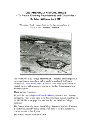
  • 1. 1 DECIPHERING A HISTORIC IMAGE – To Reveal Enduring Requirements and Capabilities - Dr Robert Williams, April 2021 “The farther back you can look, the farther forward you are likely to see.” Winston Churchill In a recent post titled “Image interpretation” I attached a historic photo. I expressed interest to see how well it would be analysed. I offered a cryptic clue - Peter Kinne FSSSI. I asked if there were any GEOINT or 'spatial' experts with answers as to what are the key features and where are they located. There were no responses. So, with the clue being Peter Kinne FSSSI there needs to be a ‘location’ connection. There is one entry in his Experience and Education entries on his LINKEDIN home page that provides the clue. It is Iona College, Brisbane. The Google Maps clip shows Iona College, Wynnum North (or Lindum) at the bottom. Directly north, on the south bank of the Brisbane River, near the mouth, is Fort Lytton. The historic photo was taken in 1963.
  • 2. 2 Google map with annotation https://www.flickr.com/photos/queenslandstatearchives/27195840409/in/ photostream/
  • 3. 3 Looking back from the Fort the suburban area is Wynnum North (on left). The hill on the horizon is probably Mt Petrie. Fort Lytton defended Brisbane continuously from colonial times until after World War 2. The historic fort consists of about a hectare of colonial buildings, tunnels and other fortified structures embedded in a protective earth-mound wall and surrounded by a 10m-wide water-filled moat. Fort Lytton's role in the Second World War was very different from previous times. It was now part of a much larger defence system. Between 1937 and 1943, four more coastal forts were built to defend Moreton Bay. These forts provided the outer defence to prevent enemy vessels from reaching the mouth of the Brisbane River, while Fort Lytton provided the inner defence. Many other defence activities were based at Fort Lytton including a signals station, a radar station and a heavy anti-aircraft battery. Brisbane's defences were progressively strengthened during WW2, in line with Brisbane's increasing strategic significance to the war effort. In particular, by 1943, Brisbane was a major submarine base. A total of 89 submarines were dry docked for repairs in Brisbane over a three-year period. Over 17,000 Australians served in the Korean War between 1950 and 1953. Fort Lytton’s signal station provided essential communications between Australian and its forces in Korea. The signal station was significantly upgraded at this stage, including upgrades to radio equipment, masts and aerials (antennas). An enduring requirement – Defending our Nation! Intelligence, surveillance, and command and control are essential capabilities and need to be complemented by mapping programs. For example, in February 1539 at Cromwell’s instigation, the King Henry VIII commissioned certain - “sadde [mature and trustworthy] and expert men of every shire in Ingland beyng nere the see . . . to viewe all the places alongest the secost wher any danger of invasions ys like to be and to certifie the sayd daungers and also best advises for the fortificacion therof”.
  • 4. 4 Returning to the historic 1963 photograph, looking south from the Fort there is a group of buildings. These buildings are the remains of the Lytton Quarantine Station. The Lytton Quarantine Station was established in 1913-1914, to accommodate newly arrived immigrants and persons considered being at risk of causing infection to the general population. Situated at an isolated location at the mouth of the Brisbane River the place illustrates early 20th century attitudes to quarantine practices and the provision of quarantine facilities. At various times the quarantine station buildings also provided accommodation for persons stationed at adjacent Fort Lytton. The fort also played a role in the function of the quarantine station, controlling ships attempting to enter the Brisbane River without appropriate health clearances. In 1919 the worldwide outbreak of Spanish Influenza which followed the end of the First World War was delayed in Brisbane by some three months, following a strict quarantine at Lytton of personnel returning on troop ships.
  • 5. 5 By 1928, the Lytton Quarantine Station facilities had been extended and enhanced. Vessels were met at the river mouth by the Health Authorities who boarded each ship and inspected all goods and personnel on board. Suspect people and goods were landed at Lytton for fumigation and isolation. Jetty facilities permitted passengers to disembark on foot and a crane was provided for conveying sick passengers, luggage and stores to shore. A tramline ran from the jetty to the reception house.
  • 6. 6 The Lytton facility functioned as a human quarantine station until the early 1980s. In 1982 the Lytton facility reverted to its earlier role as an animal quarantine station, re-designated the Lytton Quarantine Complex and Animal Detention Centre. Facilities comprised a launch jetty, workshop, inflammable store, guinea pig area, imports treatment laboratory, utility buildings area, offices, stores, and animal quarantine detention facilities. In addition to its role as an animal quarantine centre, Lytton served as a communications centre, a base for south side shipping clearance and inspection, a facility for dealing with quarantine treatment and detention of materials, a training area and a depot for stores. By the late 1980s the Lytton facility had closed completely. An enduring requirement – Safeguarding our Nation! Intelligence, surveillance, and reconnaissance; command, control and communications; targeting and assets employment; navigation and guidance; mobility and manoeuvre; and health and survival are essential capabilities in Safeguarding our Nation and need to be complemented by a Geographic Information Infrastructure. Contemporary threats to our Nation’s security include Pandemic diseases.
  • 7. 7 COVID-19 is the disease caused by a new coronavirus called SARS-CoV-2. The World Health Organization declared the outbreak a Public Health Emergency of International Concern on 30 January 2020, and a pandemic on 11 March 2020. There have, of course, been plagues throughout history including the Black Death and the Great Plague of London.
  • 8. 8 Major events, such as epidemics and disasters, often result in innovative techniques to model phenomena. One such example was the use of geographic and cartographic methods. 1854 London Cholera outbreak Possibly the earliest use of the geographic method was in 1854 when John Snow depicted a cholera outbreak in London using points to represent the locations of some individual cases. His study of the distribution of cholera led to the source of the disease, a contaminated water pump within the heart of the cholera outbreak. While the basic elements of topology and theme existed previously in cartography, the John Snow map was unique, using cartographic methods, not only to depict but also to analyse clusters of geographically dependent phenomena for the first time. Map: E.W. Gilbert's version (1958) of John Snow’s 1855 map of the Soho cholera outbreak showing the clusters of cholera cases in the London epidemic of 1854 A MATTER OF AN URGENT AND PRESSING NATURE Surely, COVID 19 must be considered as a Global Disaster that deserves reviews by nations on the way we ‘manage the health and well-being’ of our peoples - Safeguarding our Nation. We need to undertake a ‘major capability review’ – an Environmental and Geographic Information Capability Study. The world was unprepared for such an event. Back in 2001, another ‘significant’ event occurred in the USA. The event is often just referred to as ‘911’. The Report by the 911 Commission observed: “NORAD and the FAA were unprepared for the type of attacks launched against the United States on September 11, 2001. They struggled under very difficult circumstances to improvise the homeland defense against a challenge that they had never
  • 9. 9 encountered, and honestly never been trained to meet.” The Chairman also noted that: “We have failures in: POLICY, MANAGEMENT, CAPABILITY, and above all in IMAGINATION”. Surely, this list of ‘failures’ can be applied to the pandemic response. At this point, I could embark on discussion of a range of issues but I have already posted opinion papers including “Something Happened at Dayton, Ohio - A Butterfly Flapped its Wings - And a Nation Burns” [An Opinion by Dr Robert Williams, January 2020]. In my opinion, the first topic [POLICY] is critically important. On 11 March 2020 the World Health Organisation declared the outbreak a pandemic. At that time the Federal Government should have invoked a National Emergency thereby activating a National Disaster Organisation with a Command Support Infrastructure within a National Mapping Agency.
  • 10. 10 But, we don’t have a specialist, dedicated National Mapping Agency nor a specialist, and dedicated National Disaster Organisation. And, in my observation, have a critical lack in expertise, skills and nationally recognised formally qualified staff in the agencies. An example noting the lack of appropriately qualified experts was commented on by former US DCI in 2004 as “when asked last fall about pending intelligence reform, former Director of Central Intelligence George Tenet said he felt like a patient on an operating table who, while being prepared for brain surgery, found himself surrounded by 12 surgeons, NON of whom had gone to medical school”. Just a cursory examination of the formal qualifications of executive level officers in key agencies reveals awards including Bachelor of Arts degrees (English; French Language and Literature; Asian Studies; Biology; etc); Bachelor of Science (Forestry; Zoology; Environmental Management; etc); Bachelor of Physics; Bachelor of Electrical Engineering; Bachelor of Mechanical Engineering; Bachelor of Economics and MBAs. Where are the experts – the geodesy and cartography scientists and the surveying and mapping professionals? Of course, appropriate qualifications and training are not the only concerns. There are many topics that need analyzing but as I have used the term Safeguarding our Nation I will follow that stream focusing on conferences and symposiums. In 2002, the Prime Minister of Australia announced Australia’s National Research Priorities. These were: • An Environmentally Sustainable Australia, • Promoting and Maintaining Good Health • Frontier Technologies for Building and Transforming Australian Industries and • Safeguarding Australia.
  • 11. 11 In 2002 the first of a series of Homeland Security Conferences was held in Canberra. The fourth in the series was titled Safeguarding Australia 2005. Day 3 included a (SET Science, Engineering and Technology) Summit and was led by the Honourable Gary Nairn MP, Special Minister of State. The first of a series titled Spatially Enabled Government followed, commencing in 2007. Hon Gary Nairn MP, Special Minister of State ‘Promoting the Australian Government Spatial Agenda’ 14 August 2007 “Given my background as a surveyor, it has also been an ideal opportunity to champion the use of spatial technology and information in Government – to drive the Australian Government to become more spatially enabled. It is clear that adding a spatial dimension to data will lead to better decisions – providing the right services at the right time at the right place”. 2007 Policy and Decision Making to Manage, Extend, Plan and Deliver on Spatial Capability 2008 Policy to End User – Maximising the Value of Geospatial Data in Government to Enhance Service Delivery and Evidence Based Policy 2009 Technical and Decision Making for Mapping the Future of Interoperability, Data Collection & Data Management, For Operational Excellence within Australian Government Then followed a focused series titled Spatial@Gov. Location as an Enabler for Government Business 2009 Building Spatial Capability For Government The Conference program addressed the rapidly increasing demand for information on how location can be used as an enabler to support governments at all levels to inform their policy development, enhance service delivery and gain efficiencies in internal business processes. 2010 Aligning The Spatial Capabilities Of The Three Tiers Of Government The spatial@gov® conference was a collaborative initiative of the key organisations representing the public, commercial, research, education
  • 12. 12 and professional sectors of the spatial community in Australia and New Zealand. 2011 Spatial@Gov2011 Conference themes included: • Water Security • Spatial@Defence • Government Spatial Activities in Other Countries • Access to Government Spatial Information • Emergency Response • The Spatial Framework for Virtual Australia 2012 Future Directions: Linking People, Policy and Place The conference program addressed two broad categories: • The Strategy theme explored the policy settings required to ensure that Governments can best use location-based business intelligence in support of better informed policy and planning decisions, and more efficient targeted service delivery to Australian and New Zealand citizens. • The Innovation theme looked closely at emerging and future trends and how Governments might work with the commercial and research sectors in order to drive future innovation in the Australian and New Zealand Spatial Community and globally. At the 2012 Spatial@Gov conference the Assistant Secretary of Spatial Policy at the Department of Communication announced, what was described as, “a unification of the spatial industry”. “Locate was the first step to unify the Australasian spatial industry. Before Locate came into existence in 2014, there were multiple annual spatial national conferences, including spatial@gov, the Surveying and Spatial Science Conference, and the Asia Pacific Spatial Excellence Awards events”. Locateconference.com Over the years the numbers attending Locate Conferences appear to have increased and conferences have expanded to have multiple parallel sessions. The conferences have promoted “collaboration”, “cooperation” and other contemporary trends to the extent that they have become more of social networking events rather that specialist conferences. The term “spatial” was promoted to be an “inclusive” concept but it has had the effect of alienating a broad range of professionals. To qualify this point I recall my recent experience. I am retired and live on the far south coast of New South Wales. Locate21 was a hybrid event with live and virtual participation. The host city was Brisbane. There were ‘live’ sites at a number of cities including
  • 13. 13 Canberra. I travelled to Canberra and stayed at the conference hotel. There were only 15 people in attendance in the conference room on day 1. There was a Happy Hour and networking event; I was the only one there. At the APSEA awards and closing, again, I was alone in the room. Then there was only one stall – HERE technologies. And there were no ‘live’ presenters. One would have thought that a city like Canberra with its agencies, private industries, universities and research laboratories would have provided greater participation. Perhaps this experience is an indicator that, rather than advancing a profession, terms like “spatial”, “locate” and “space and spatial” have been disruptive. They are vague and ill-defined. With the challenges confronting our world such as the pandemic it seems that we should go Back to the Future to assist in evolving our Safeguarding Australia capabilities. I have participated in many conferences and symposiums over the past four and a half decades and observe that the1996 conference of the Mapping Science Institute Australia had a theme and structure that is relevant today. See conference cover and preface below. But what about IMAGINATION? When I look back over my long career (over half a century) I have been fortunate to hear from VISIONARIES! But that part of my story is for another day. Reference Queensland Government website https://apps.des.qld.gov.au/heritage- register/detail/?id=601347# _________________________________ This link (below) is evidence that the phrase “Back to the Future” is being used by others. Alan Kohler has also highlighted ‘quarantine stations’. Alan Kohler Back to the Future https://thenewdaily.com.au/finance/2021/04/29/alan-kohler- quarantine-vaccines/
  • 14. 14