Download to read offline
![BACK TO THE FUTURE:
Policy
Dr R.J. (Bob) Williams [Retired]
Cartographer
Topographic Surveyor,
Geographer & Geospatial Scientist
February 2022
Supporting slides to
presentation at
HYDROSPATIAL 2021](https://image.slidesharecdn.com/rjwpolicy-220307224850/85/Back-to-the-Future-Policy-1-320.jpg)
![POLICY is a deliberate system of guidelines to guide decisions and achieve rational outcomes. A policy is a statement of intent and
is implemented as a procedure or protocol. Policies are generally adopted by a governance body within an organization.
The transition from maps and charts to a ‘virtual world’ commenced
through formal directives [Policy] decades ago.
Strategic Policy
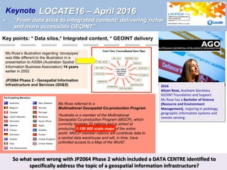
A Policy Information Paper, The Defence of Australia, was tabled in Parliament by the Minister for Defence Kim
C. Beazley on 19 March 1987.
A comprehensive geographic information system is vital to the development of a national defence
capability …”.
Cooperative Development of DIGITAL CHART OF THE WORLD (DCW)
Agreement Between The Government Of Australia And The Government Of The United States Of
America Concerning Cooperative Development Of The Digital Chart Of The World - AUSTRALIAN
TREATY SERIES 1990 No.23
The DCW project was a joint R&D (Research and Development) venture involving the US, Australia,
Canada and the UK, and developed internationally accepted standards for the exchange of digitally
based mapping, charting and geodetic information.
Multi-national Co-production – VaCWG and MGCP
DGIWG is the multi-national body responsible to the defence organizations of member nations for coordinated
advice and policy recommendations on geospatial standardization issues.
DGIWG is the custodian of DIGEST (Digital Geographic Information Exchange Standard). DIGEST includes
a structure known as VRF (Vector Relational Format) and a Feature and Attribute Coding Catalog (FACC).
VMap Co production Working Group (VaCWG) managed VMap Level 1 [1:250,000 equiv]
The Multi-national Geospatial Co-Production Program (MGCP) was initiated in 2003.
2001](https://image.slidesharecdn.com/rjwpolicy-220307224850/85/Back-to-the-Future-Policy-2-320.jpg)
![POLICY is a deliberate system of guidelines to guide decisions and achieve rational outcomes. A policy is a
statement of intent and is implemented as a procedure or protocol. Policies are generally adopted by a
governance body within an organization.
Ø DCW (Digital Chart of the World) – Research and Development Agreement with Treaty status
Ø DGIWG / DIGEST – Multi-national cooperation through formal agreement [Standards]
Ø VaCWG / MGCP – Multi-national co-production through formal arrangements [geospatial database]
Computers have been used in the map-making process since the 1960s.
From a formal Policy perspective a significant stimulus occurred in 1987.
“The Government’s Defence policy and program is comprehensively covered in the
Policy Information Paper, The Defence of Australia, which I tabled in Parliament on
19 March 1987.
… … …
Recent developments in technologies and systems relevant to geographic information
systems show promise. … …
A comprehensive geographic information system is vital to the development of a
national defence capability and consequently this book is a welcome contribution to
this area of Australia’s defence effort. I hope it will provide stimulus for further research
and discussion”.
Kim C. Beazley, November 1987
Then followed:
Government Information Paper
“The Defence of Australia”, 1987
Policy](https://image.slidesharecdn.com/rjwpolicy-220307224850/85/Back-to-the-Future-Policy-3-320.jpg)
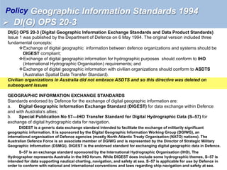
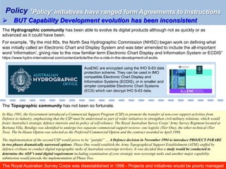
![DCW – Digital Chart of the World - 1990
A project to develop a Digital Chart of the World (DCW) was first proposed by the US Defense
Mapping Agency (DMA) in early 1988. The DCW project was a joint R&D (Research and Development)
venture involving the US, Australia, Canada and the UK, and developed internationally accepted standards for
the exchange of digitally based mapping, charting and geodetic information. The Australian partner in the DCW
project was the Royal Australian Survey Corps (RASVY). The project was funded through the Nunn
Amendment to the 1987 US Military Appropriations Bill, which provided for the funding of approved cooperative
R&D projects with certain NATO and non-NATO countries.
AUSTRALIAN TREATY SERIES 1990 No.23
AGREEMENT BETWEEN THE GOVERNMENT OF AUSTRALIA AND THE
GOVERNMENT OF THE UNITED STATES OF AMERICA CONCERNING
COOPERATIVE DEVELOPMENT OF THE DIGITAL CHART OF THE WORLD
Studies
Statement Of Work – Feb 1989
Initial Tile Design Study - Dec 1989
Initial Elevation Data Study – Feb 1990
Initial Aeronautical Info Study – Feb 1990
Vector Product Format – March 1991
Prototypes
Digital Cities Database
Digital Nautical Chart
Digital Terrain Database
Digital Gazetteer
This project resulted in a Topologically-structured [vector] database of the World
[produced from the 1 : 1,000,000 ONC (Operational Navigation Charts).
Features were coded using DMA’s FCS (Feature Coding Scheme). …
DATABASE STRUCTURE COMPATIBLE FOR USE IN COMMERCIAL GIS
VPFVIEW
Vector [Smart] Maps
Policy](https://image.slidesharecdn.com/rjwpolicy-220307224850/85/Back-to-the-Future-Policy-4-320.jpg)
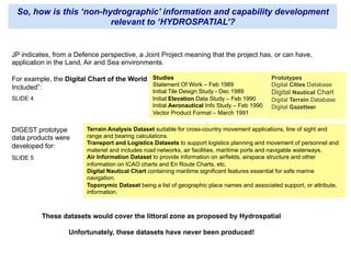
![PROJECT PARARE was named in 1988 from the Royal Australian
Survey Corps motto, videre parare est, and planning began in
1989.
It was hard for many “to grasp the revolutionary new way of
thinking about topographic information in which their primary
goal, the printed map, became just one of many products from a
topographic database that would provide a vastly increased
military capability for the Australian Defence Force.
PROJECT PARARE was to be a digital system that could produce
a variety of products from a spatially related topographic
database. Maps and charts, reports, photo products, statistics
and topologically structured spatial data would provide the
topographical base reference layers for a military geographic
information system. The topographic information provided would
assist with terrain analysis, command and control systems,
weapons systems, and war gaming”.
Valerie Lovejoy’s
Mapmakers of Fortuna
A History of the Army Survey
Regiment
Ex-Fortuna Association,
Bendigo, 2003
ISBN 0 646 42120 4
Ø A transformational project at a time of major organisational change
Project Parare – [Army JP42 – Joint Project] 1988-1996
PARARE would be split and re-split and downsized and delayed until the Project was terminated.
It was replaced by JP 2064 – Geospatial Information and Services. That project would also be subject to
changes, often at the advice of people with limited qualifications.
THIRTY YEARS ON THE ‘TRANSFORMATIONAL CAPABILITY IS YET TO HAPPEN](https://image.slidesharecdn.com/rjwpolicy-220307224850/85/Back-to-the-Future-Policy-11-320.jpg)
![Photo taken in December 1979 of
[then] SSGT Bob Williams
Military symbols produced using
PLOT10 software
[Then] SSGT Bob Williams – First supervisor of the
Royal Australian Survey Corps’ Input Sub-system of
Automap 1 at ‘Fortuna’, Bendigo -1976
Dr Bob Williams an observer at DGIWG
meting held in Madrid, Spain 1993. He
was the first Australian participant.
Robert (Bob) Williams
One of Australia’s Military Mapmakers](https://image.slidesharecdn.com/rjwpolicy-220307224850/85/Back-to-the-Future-Policy-13-320.jpg)

- Policy initiatives from the 1980s aimed to establish guidelines for geospatial data standards and multi-national cooperation through agreements like the Digital Chart of the World project and the Digital Geographic Information Working Group. - The 1987 Defence policy paper and 1994 DI(G) OPS 20-3 directive endorsed standards like DIGEST and S-57 to facilitate geospatial data exchange. - However, transformational projects like Project Parare in the 1990s that aimed to establish a digital geospatial capability faced challenges and inconsistencies, and the capability is still being developed over 30 years later.


![[Day 3] Agcommons Quickwin: gRoads](https://cdn.slidesharecdn.com/ss_thumbnails/cgiar-csi-day3-2apr2009-agcommons-quickwin-groads-090405003027-phpapp01-thumbnail.jpg?width=640&height=640&fit=bounds)


![Future Defence Geospatial Environment Future [2000]](https://cdn.slidesharecdn.com/ss_thumbnails/futuregeoenv2000-210923064710-thumbnail.jpg?width=640&height=640&fit=bounds)


