This document summarizes a BA Computing Studies degree with a major in Cartography from the CCAE (Central Computer Applications Establishment).
The core disciplines of the degree are Cartography, Mathematics, and Computer Science. Course topics include datums and coordinate systems, terrain modelling, computer programming, numerical analysis, and machine intelligence.
An example assignment from a Remote Sensing course is described, requiring the processing of LANDSAT imagery to extract and map Lake Burley Griffin and its features in Canberra.
The document also discusses early concepts for automated object and feature recognition from maps and imagery to fulfill queries, as well as the development of interactive mapping software called WIMS for the Joint Intelligence Organisation.
Short presentation on spatial data, what it is, how it works and some common errors. Presented at Irish Computer Society seminar on Data Quality, Dublin, September 13 2010.
OrangeNXT - High accuracy mapping from videos for efficient fiber optic cable...BigDataExpo
Construction companies such as BAM Infra Telecom rely on accurate, up-to-date maps. Google Maps isn’t enough, but doing on-site surveys is expensive and time-consuming. However, driving through and recording 360° video from a car is cheap and easy. Using machine learning, we turn videos into highly accurate maps.
Final presentation for Ordinance Survey sponsored MSc ProjectIris Kramer
MSc Archaeological Computing (GIS and Survey), University of Southampton.
“An archaeological reaction to the remote sensing data explosion. Reviewing the research on semi-automated pattern recognition and assessing the potential to integrate artificial intelligence”
Slides from a presentation by Benjamin Hennig at the ESRI International User Conference in San Diego, 15 July 2009. See more at http://www.viewsoftheworld.net/?p=654
Explore the findings of McCain McMurray, Remote Sensing Specialist at NewFields, who surveyed an open pit mine in New Mexico to assess the accuracy of the senseFly eBee mapping UAS (UAV/drone).
Pleiades - satellite imagery - very high resolutionSpot Image
With the Pleiades constellation, comprising the Pleiades-1 and Pleiades-2 satellites, Spot Image is set to bring you satellite imagery at a resolution of 50 cm and with a footprint of 20 km x 20 km.
More information on http://www.spotimage.com/pleiades
Landsat data and its application in landuse and landcover .(NIT ROURKELA)IndrajeetKumar110
Landsat data and its application in landuse and landcover .classification of mining area and technology of assessing the use of land for various large scale development
Presentation by Benjamin David Hennig for the 46th Annual Meeting of the Society of Cartographers, Manchester/UK, 9th September 2010. Read more at http://www.viewsoftheworld.net/?p=832
Dare to Change 1980Reflections of one of Australia's Military MapmakersRobert (Bob) Williams
It was 40+ years ago!
Reflections of One of Australia’s Military Mapmakers
(SPR / CPL / SGT / SSGT / LT / CAPT / MAJ / DR)
Robert (Bob) Williams
Cartographic Information Systems – DES and MAPPACK:
Then wait; there’s more!
My reflection is the the Mid-70s to Mid-80s were Enlightening years. This presentation describes my activities for that timeline including studies at the Canberra College of Education
This presentation describes activities at the Australian Army Survey Regiment, Fortuna, Bendigo, Victoria related to the introduction of digital mapping in the 1970s and 80s.
A presentation by Dr Bob Williams - retired topographic surveyor and cartographer. Fortuna was the 'home' of the Royal Australian Survey Corps' Army Survey Regiment and was an amazing place that deserves being recognised for its role in the development of computer mapping.
Looking into the past - feature extraction from historic maps using Python, O...James Crone
Tutorial presentation providing an overview of extracting geospatial features from scanned historic maps in an automated fashion using Python, OpenCV and PostGIS.
For the full video of this presentation, please visit: https://www.edge-ai-vision.com/2022/08/event-based-neuromorphic-perception-and-computation-the-future-of-sensing-and-ai-a-keynote-presentation-from-ryad-benosman/
Ryad Benosman, Professor at the University of Pittsburgh and Adjunct Professor at the CMU Robotics Institute, presents the “Event-Based Neuromorphic Perception and Computation: The Future of Sensing and AI” tutorial at the May 2022 Embedded Vision Summit.
We say that today’s mainstream computer vision technologies enable machines to “see,” much as humans do. We refer to today’s image sensors as the “eyes” of these machines. And we call our most powerful algorithms deep “neural” networks. In reality, the principles underlying current mainstream computer vision are completely different from those underlying biological vision. Conventional image sensors operate very differently from eyes found in nature, and there’s virtually nothing “neural” about deep neural networks. Can we gain important advantages by implementing computer vision using principles of biological vision? Professor Ryad Benosman thinks so.
Mainstream image sensors and processors acquire and process visual information as a series of snapshots recorded at a fixed frame rate, resulting in limited temporal resolution, low dynamic range and a high degree of redundancy in data and computation. Nature suggests a different approach: Biological vision systems are driven and controlled by events within the scene in view, and not – like conventional techniques – by artificially created timing and control signals that have no relation to the source of the visual information.
The term “neuromorphic” refers to systems that mimic biological processes. In this talk, Professor Benosman — a pioneer of neuromorphic sensing and computing — introduces the fundamentals of bio-inspired, event-based image sensing and processing approaches, and explores their strengths and weaknesses. He shows that bio-inspired vision systems have the potential to outperform conventional, frame-based systems and to enable new capabilities in terms of data compression, dynamic range, temporal resolution and power efficiency in applications such as 3D vision, object tracking, motor control and visual feedback loops.
Nearly every military vehicle and every satellite that flies into space uses the GPS to fix its position. In this popular 4-day short course, GPS expert Tom Logsdon will describe in detail how those precise radionavigation systems work and review the many practical benefits they provide to military and civilian users in space and around the globe.
Mission Planning and Execution for the Unmanned Rotorcraft ARTISFlorian-Michael Adolf
Wrap-up slide deck on functions developed for the Unmanned Rotorcraft ARITS' Mission Planning and Execution Framework (MiPlEx) as well as a preliminary outlook into adaptations to (unmanned) fixed-wing aircraft kinematics.
My Hydrospatial 21 presentation titled "Back to the Future: The Climate for Change and the Hydrographer of the Future" contained a number of slides noting supplement.
This presentation is the Rosetta link. It suggests that visionary capabilities are possible and uses components of the Rosetta mission with past capabilities.
This is an overview of a cartographic mapping package developed at the Canberra College of Advanced Education. The package demonstrates educational and navigational applications and was produced for the semester unit Special Studies in Computing in the course for the award of Bachelor of Arts in Computing Studies.
It was 20 years ago!
Dare to Change - Geographic Intelligence – The Key to Information Superiority
Request for assistance:
“I’ve lined up CDF (Chief of the Defence Force) to give a luncheon talk to the members of ASIBA (Australasia Spatial Information Business Association) on Thursday 10 October. Naturally I will have to write his speech! If you have any particular thoughts on what I might include, I would be grateful. The aim will be to give the spatial industry lobby a feeling that Defence recognises, values and needs quality geo information in many areas.
As well, I’ve agreed to speak to AURISA (Australasian Urban and Regional Information Association) on November 27 – guest / keynote speaker I think. Again any ideas you might want to proffer would be welcome”.
[Director, DIGO]
Geospatial Intelligence in Support of the Australian Approach to WarfareRobert (Bob) Williams
This paper (written in 2003) introduces the term geospatial intelligence to the lexicon of Australia’s national security. The paper describes a framework of concepts as they apply to imagery, imagery intelligence, and geographic, infrastructure and environmental information, referred to collectively as Geospatial Intelligence. The paper also describes the means of acquiring, processing and disseminating the range of products and services to the Defence community, referred to as Geospatial Information Infrastructure.
The article linked to (below) is somewhat of an odyssey. It commences with discussion on, possibly, the first land information system in Australia and my association with it - Eurobodalla.
It then briefly describes follow on applications including a military terrain-mapping product. Subsequent products cover the littoral zone for beach landings. So, it could be described as terrain intelligence.
This idea stemmed from the D-Day invasion maps (Benson and Bigot).
And, so, follows the Benson and Bigot story – an amazing cartographic accomplishment. To view a video of this stunning activity view the link at the end of the article
The article linked to (below) is somewhat of an odyssey. It commences with discussion on, possibly, the first land information system in Australia and my association with it - Eurobodalla.
It then briefly describes follow on applications including a military terrain-mapping product. Subsequent products cover the littoral zone for beach landings. So, it could be described as terrain intelligence.
This idea stemmed from the D-Day invasion maps (Benson and Bigot).
And, so, follows the Benson and Bigot story – an amazing cartographic accomplishment. To view a video of this stunning activity view the link at the end of the article.
Hydrospatial 21 [Education] - Dr Bob Williams
My presentation at Hydrospatial 21 at Cairns in February 2022 was titled "Back to the Future: The Climate for Change and the Hydrographer of the Future". It referred to supplementary information in other presentations.
This supplementary presentation describes "Education" and related topics; a personal experience
EDUCATION is the process of facilitating learning, or the acquisition of knowledge, skills and personal development and should be an enlightening experience.
Hydrospatial 21 [Policy] - Dr Bob Williams
My presentation at Hydrospatial 21 at Cairns in February 2022 was titled "Back to the Future: The Climate for Change and the Hydrographer of the Future". It referred to supplementary information in other presentations.
This supplementary presentation describes "Policy" and related topics.
POLICY is a deliberate system of guidelines to guide decisions and achieve rational outcomes. A policy is a statement of intent and is implemented as capability development.
My Hydrospatial 21 presentation titled "Back to the Future: The Climate for Change and the Hydrographer of the Future" contained a number of slides noting supplement.
This presentation is the Capability Development link. CAPABILITY is defined as the capacity to achieve a specific effect, in a nominated operating environment or location, within a specific degree of notice, and to sustain that effect for a given time. CAPABILITY has as its components: personnel; education and training; equipment; organisation; structure; deployment; preparedness; and doctrine
Back to the Future: The Climate for Change and the Hydrographer of the FutureRobert (Bob) Williams
This presentation was given at Hydrospatial 2021 held in February 2022 at Cairns, Queensland. The presentation looks at capability of the futuristic Oceania Infrastructure and Environmental Support System.
A presentation to supplement a presentation titled "Back to the Future: The Climate for Change and the Hydrographer of the Future" given at Hydrospatial21 held in cairns February 2022
Research and development project proposal written in december 1994. The purpose was to offer a strategy and a commitment to an evolutionary approach in the development of a system to provide Regional Geospatial Information and service.
Geographic intelligence. This presentation was developed in 2000-2001 in response to a question from a senior military officer who asked "how much geographic information do I need and what can go wrong if I haven't got it"!
Digital transformation and the concept of a 'virtual world' was a topic of interest in the 1990s. The Australian Defence Organisation conducted a number of major capability studies in the mid 1990s including the Environmental and Geographic Information Capability Study. Following on from that I presented this presentation.
eGeoBrief - Afghanistan - Facilities
The Facilities presentation was produced in October 2001.
The overall eGeoBrief has presentations for History, Geography, Politics, Communications, Facilities, Resources, Economy and Envronment.
CAUTION:
Information contained in this product has been compiled from a range of sources from the Internet.
Information has NOT been independently validated.
This product has been developed as a ‘proof of concept’ for electronic geographic briefs (eGeoBrief)
There are moments in one’s career that, in retrospect, hold significance. The 24th August 2001 is one of those days – 20 years ago today.
On 23rd August I travelled from Adelaide to Canberra and gave a number of presentations on my recent overseas trip on 24 August 2001.
In this document I introduce two audacious initiatives: Aeronatical Intelligence and eGeoBriefs (via an avatar).
Twenty years ago various organisations and professional bodies were developing leading edge capability in geospatial infrastructures. This presentation following an overseas visit was given to various groups in Canberra on 24 August 2001.
This is a story of an amazing military mapping organisation and its iconic home - Fortuna Villa, Bendigo. The document include many photographs, figures, and descriptions.
In presenting his report on the 9/11 Commission Report, Thomas Kean stated "We have failures in: Policy, Management, Capability and above in IMAGINATION". This article follows on from my previous post "Deciphering a Historic Image; To reveal enduring requirements and capabilities". So, now, let me introduce you to Fitzy, desmond, Wally and Ben.
This paper takes us on a journey by deciphering the image to identify nationally important capabilities and to present day challenges focusing on Safeguarding a Nation from contemporary threats.
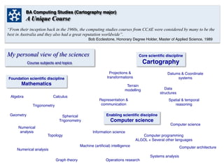
1. BA Computing Studies (Cartography major)
A Unique Course
“From their inception back in the 1960s, the computing studies courses from CCAE were considered by many to be the
best in Australia and they also had a great reputation worldwide”.
Bob Ecclestone, Honorary Degree Holder, Master of Applied Science, 1989
My personal view of the sciences Core scientific discipline
Cartography
Foundation scientific discipline
Mathematics
Enabling scientific discipline
Computer science
Projections &
transformations
Spatial & temporal
reasoning
CalculusAlgebra
Geometry
Trigonometry
Numerical
analysis
Spherical
Trigonometry
Course subjects and topics
Datums & Coordinate
systems
Topology
Data
structures
Terrain
modelling
Information science
Computer science
Computer programming
ALGOL + Several other languages
Systems analysis
Computer architecture
Numerical analysis
Graph theory
Operations research
Machine (artificial) intelligence
Representation &
communication
2. CCAE
Origins
A Unique Course
Remote Sensory Mapping – Assignment 1
Lecturer: Dr Grahame Smith
Assignment 1 required the use of LANDSAT data and required the following tasks:
² Reduce a scene (150 scan lines in length and 480 pixels wide) of central Canberra
sensed on 18 November 1975 to a new scene 50 lines in length and 160 pixels
wide. There are many methods of accomplishing this reduction, you should carry
out at least two. Included with map outputs should be a discussion of the merits
and demerits of your methods.
² Using thresh-holding techniques extract Lake Burley Griffin from your reduced
scene. You should produce a map of the lake, together with an account of the
methods you used to get it.
² Locate the bridges and other non-water features of the lake. Produce these as an
overlay for your lake map.
The photographic images (below) did not become available until later in the course. The
images were processed by Dr John O’Callaghan at CSIRO. Thus, photographic images
were not in existence at the time of the actual assignment. Naivety can be beneficial in
conducting innovative work.
LANDSAT scene of Canberra
Sensed 18 November 1975
Bridges
Shoreline of
Lake Burley Griffin
Comment
Bridges X
Shore *
Fountain in front of
Old Parliament
House*
Google Earth 2014
3. Typical object recognition enquiries might take
the form:
• What is the feature 5KM north-west of the
junction of road A and road B?
• Give details of this building (pointed to on a
screen).
• What is this feature (pointed to on a screen)?
Examples of these types of queries may take the form:
• Show a base map bounded by 20OS, 25OS, 130OE and 132OE
and highlight the bores.
• Locate and list details of the nearest airfield to
the town of Kyogle, NSW
• Plot all roads between Dubbo NSW and Bourke NSW to a
distance of 100KM from the centre line
A DEFENCE ENQUIRY SYSTEM (DES)
LT R.J.Williams
1980
Photo taken in December 1979 of (then) SSGT
Bob Williams. Military symbols produced using
Tektronix PLOT 10 software.
Fulfilling a Promise!
… a discussion paper on where I thought that the
Royal Australian Survey Corps should be heading …
1980
Below are copies of extracts from the original paper with
scanned copies of the original illustrations.
Abstract “an emergency situation, whether it be military
in nature or a natural disaster, often tests the speed of
response of sub-units of an organisation. Planning,
staffing, coordinating, directing and controlling decisions
are required in a limited time frame”.
Object recognition. Today’s orthophotomap may be replaced
by a digital image, perhaps similar to LANDSAT images, and
various features highlighted or classified. It might also
be feasible that digital terrestrial cameras of the future
could be used to identify features (possibly with the help
of symbol tables and definitions).
4. I again rewrote my
mapping software in
FORTRAN77 this time for
use by the Joint
Intelligence Organisation
(JIO) for use on a HP2100
series computer.
I called my software WIMS
(World Interactive
Mapping Software).
Vision – World (or
Williams) Interactive
Mapping System that could
automatically extract
information from a world
data base determined by
place names and search
criteria.
Applications would include
producing background
maps in normal, radial and
oblique rectangle formats
anywhere in the world.
Fulfilling a Promise! Returing to JIO (Joint Intelligence Organisation)..
… the year after the Falklands War …
1983