Download as PDF, PPTX
![BACK TO THE FUTURE:
Capability Development
I don't think of what I do as science fiction,
I think of it as historical reports of events that haven't happened yet!
Dr R.J. (Bob) Williams [Retired]
Cartographer
Topographic Surveyor,
Geographer & Geospatial Scientist
February 2022
Includes several slides from presentation titled
“BACK TO THE FUTURE: OIESS2025 – Burrows – Rosetta”](https://image.slidesharecdn.com/rjwcapdev-220303220122/85/Back-to-the-Future-Capability-Development-1-320.jpg)
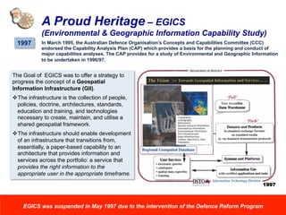
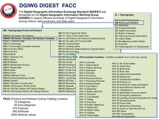
![• Bathymetry / Bottom topography
• Bottom slope
• Bottom morphology (type, trafficability)
• Underwater obstacles and obstructions
• Beaches (composition, slope, obstacles)
• Riverine (width, depth, gradient)
• Land (vegetation, trafficability)
• Q-Routes
• Magnetic
• Miscellaneous (fishing, shipping,
industrial, marine life)
Content
Bottom characteristics
Material composition category
Material composition secondary
Material composition underlying
Physical surface characteristics
BF010
MCC
MCS
MCU
PSC
Obstruction (nautical)
Wreck
BD070
BD180
Route (Maritime)
Swept area
Maritime area
FC165
FC177
FC031
- Littoral Information [Example with DIGEST Features and Attributes]
EGICS – A Maritime Perspective
(OIESS – Capability Development Process)](https://image.slidesharecdn.com/rjwcapdev-220303220122/85/Back-to-the-Future-Capability-Development-7-320.jpg)

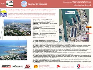
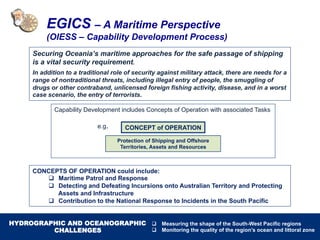
![Location
Profile PORT OF TOWNSVILLE
Intended use: Transport & Logistics
Tactical ops (Level 2)
Road access
Port authority
Townsville Port Authority
Phone 07 4790 2111
Hydrographic info
RAN Hydrographic Service
Phone 02 4221 8500
Berth 1
Petroleum products
One 150mm pipeline
Two 300mm pipelines
Storage capacity - 165,000 tonnes
LPG
One 250mm pipeline
Storage capacity - 1,250 tonnes
Berth 2
General cargo
One travelling jib crane
Berth 3
One travelling gantry container crane
Heavy lift capacity - 56 tonnes
Storage area - 2.8ha
Roll-on / roll-off
Stern ramp available
Berth 6
General cargo
LPG Depot
CALTEX Depot
SHELL Depot
MOBIL Depot
S19 15
E146
50
Berth 10
Containers
Mobile crawler crane
Lift capacity - 130 tonnes
Storage area - 2.6ha
Roll-on / roll-off
Stern / bow ramp available
Platypus Channel
Dredged to 10.3 metres
Dredged to
9.5m
Swinging basin
dredged to 10.5m
Berth 9
Passenger cruise vessels
Scale bar [KM]
1
0
Links to
Owners and
operators
Wharf
infrastructure
Navigation
aids
Power and
fuel facilities
Communications
and
emergency services](https://image.slidesharecdn.com/rjwcapdev-220303220122/85/Back-to-the-Future-Capability-Development-11-320.jpg)

The document discusses the development of environmental and geographic information capabilities for the Australian Defence Force (ADF), emphasizing its importance in military operations. It outlines the historical context, studies, and strategies from 1995 to 1997, focusing on the capacity to collect and use geographic data for various defense tasks. Key elements include the proposal for a geospatial information infrastructure and the identification of information requirements related to maritime operations and logistics.


![Future Defence Geospatial Environment Future [2000]](https://cdn.slidesharecdn.com/ss_thumbnails/futuregeoenv2000-210923064710-thumbnail.jpg?width=640&height=640&fit=bounds)


