![PyModESt : A Python Framework for Staging of Geo-referenced Data on the Collaborative Climate Community Grid (C3-Grid) Henning Bergmeyer German Aerospace Center Simulation- and Software Technology Henning.Bergmeyer [at] dlr.de](https://image.slidesharecdn.com/2009-02-18pymodest-090308162651-phpapp01/85/PyModESt-A-Python-Framework-for-Staging-of-Geo-referenced-Data-on-the-Collaborative-Climate-Community-Grid-C3-Grid-1-320.jpg)
![PyModESt : A Python Framework for Staging of Geo-referenced Data on the Collaborative Climate Community Grid (C3-Grid) Henning Bergmeyer German Aerospace Center Simulation- and Software Technology Henning.Bergmeyer [at] dlr.de](https://image.slidesharecdn.com/2009-02-18pymodest-090308162651-phpapp01/75/PyModESt-A-Python-Framework-for-Staging-of-Geo-referenced-Data-on-the-Collaborative-Climate-Community-Grid-C3-Grid-1-2048.jpg)
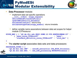
![PyModESt Metadata Update md.removeQuicklook() md.filterContentInfo(self.thesaurus.translateToC3( self.requested_vars, self.object_id)) md.setHorizontalBounds(self.lon_min, self.lon_max, self.lat_min, self.lat_max) md.setVerticalExtent(self.alt_min, self.alt_max, self.alt_verticalcrs) md.updateTimePeriod(self.timeperiod_begin_date, self.timeperiod_stop_date) md.setObjectId(self.object_id + "." + datetime.utcnow().isoformat().replace(":","-")) md.addLineageProcessStep( PROCESS_DESCRIPTION, datetime.datetime.utcnow(), self.stage_request.object_ids[0], RESPONSIBLE_PERSON, "http://wis.wmo.int/2006/catalogues/gmxCodelists.xml#CI_RoleCode_distributor", INSTITUTE_IDENTIFIER)](https://image.slidesharecdn.com/2009-02-18pymodest-090308162651-phpapp01/85/PyModESt-A-Python-Framework-for-Staging-of-Geo-referenced-Data-on-the-Collaborative-Climate-Community-Grid-C3-Grid-14-320.jpg)
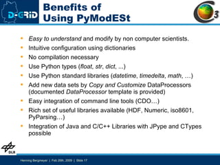


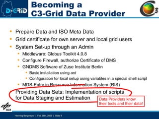
PyModESt is a Python framework that allows meteorological data providers to easily implement staging scripts for the Collaborative Climate Community Grid (C3-Grid) in a modular way. It handles common tasks like communication, metadata handling, and file management so data providers can focus on retrieving and packaging their data. Open issues include standardizing variable names across data sets and improving authorization methods.


![[Paper Reading] Steering Query Optimizers: A Practical Take on Big Data Workl...](https://cdn.slidesharecdn.com/ss_thumbnails/steersigmod21-210913065908-thumbnail.jpg?width=640&height=640&fit=bounds)


![Getting Started with Apache Spark: Big Data Made Simple [Free Meetup]](https://cdn.slidesharecdn.com/ss_thumbnails/apachesparkgettingstarted-260203175547-8361bcc3-thumbnail.jpg?width=640&height=640&fit=bounds)
