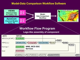
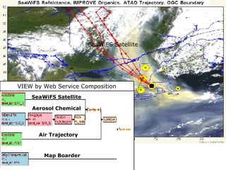
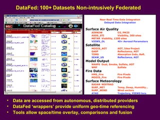
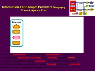
The document discusses a view-based mediated web service architecture called DataFed that federates distributed environmental science data sources. DataFed uses wrappers to provide uniform access to over 100 datasets from different providers. It allows tools to overlay, compare and fuse data in near real-time and delayed integration. The system delivers diverse information products to users through a service-oriented architecture and third-party mediation that homogenizes distributed data sources.


![Anatomy of a Wrapper Service: TOMS Satellite Image Data Wrapper Service can access and spatially subset image for any day (WMS) Wrapper Service and mediation is performed by third party This makes a non-intrusive, adoptive system for agile networking Image Description for Data Access: image_width=502 image_height=329 margin_bottom=105 margin_left=69 margin_right=69 margin_top=46 lat_min=-70 lat_max=70 lon_min=-180 lon_max=180 Daily TOMS images on FTP archive ftp://toms.gsfc.nasa.gov/pub/eptoms/images/aerosol/y2000/ea000820.gif Template: ftp://toms.gsfc.nasa.gov/pub/eptoms/images/aerosol/y[yyyy]/ea[yy][mm][dd].gif Transparent colors for overlays RGB(89,140,255) RGB(41,117,41) RGB(23,23,23) RGB(0,0,0)](https://image.slidesharecdn.com/070726-igarss07-barcelona2956/85/070726-Igarss07-Barcelona-9-320.jpg)
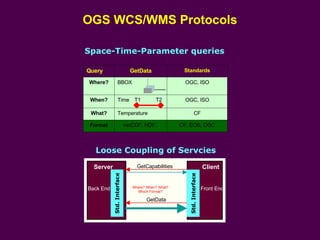
![Integrated Data System for Air Quality-IDAQ ESIP AQ Cluster 050510 Draft [email_address] The challenge is to design a general supportive infrastructure Simply connecting the relevant provides and users for each info product is messy The info system infrastructure needs to facilitate the creation of info products AQ Compliance Nowcast/Forecast Status & Trends Find Data Gaps ID New Problems ……… Info Needs Reports Providers supply the ‘raw material’ (data and models) for ‘refined’ info products Emission Surface Satellite Model Single Datasets Providers Wrappers Where? What? When? Federate Data Structuring Structuring the heterogeneous data into where-when-what ‘cubes’ simplifies the mess Slice & Dice Explore Data Viewers The ‘cubed’ data can be accessed and explored by slicing-dicing tools Programs Integrate Understand More elaborate data integration and fusion can be done by web service chaining This infrastructure support for IDAQ can be provided by the ESIP Federation Non-intrusive Linking & Mediation Data Users Data Providers](https://image.slidesharecdn.com/070726-igarss07-barcelona2956/85/070726-Igarss07-Barcelona-10-320.jpg)