Global positioning system
By
K.Gautham Reddy
2011A8ps364g
By
K.Gautham Reddy
2011A8PS364G
Introduction
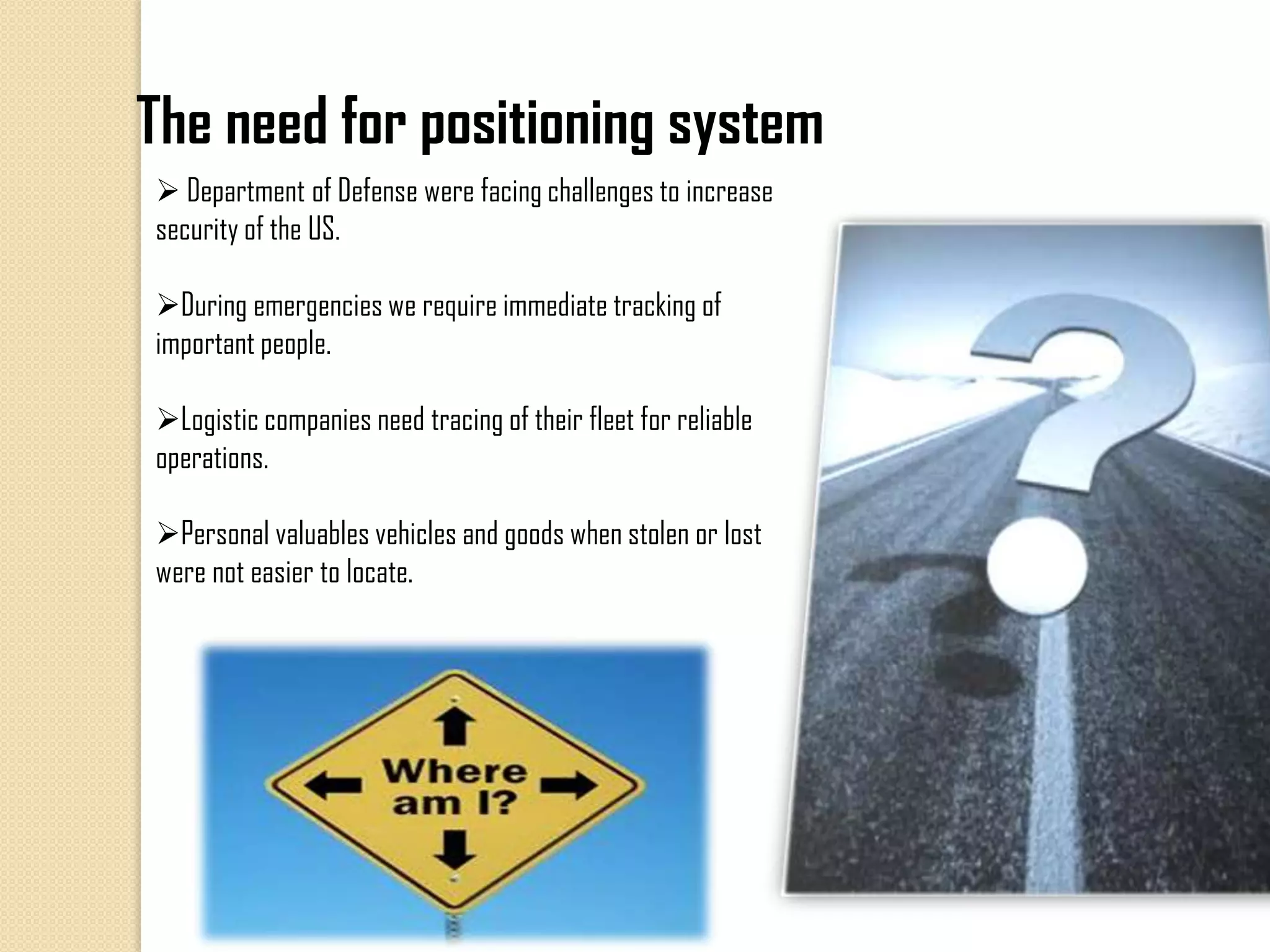
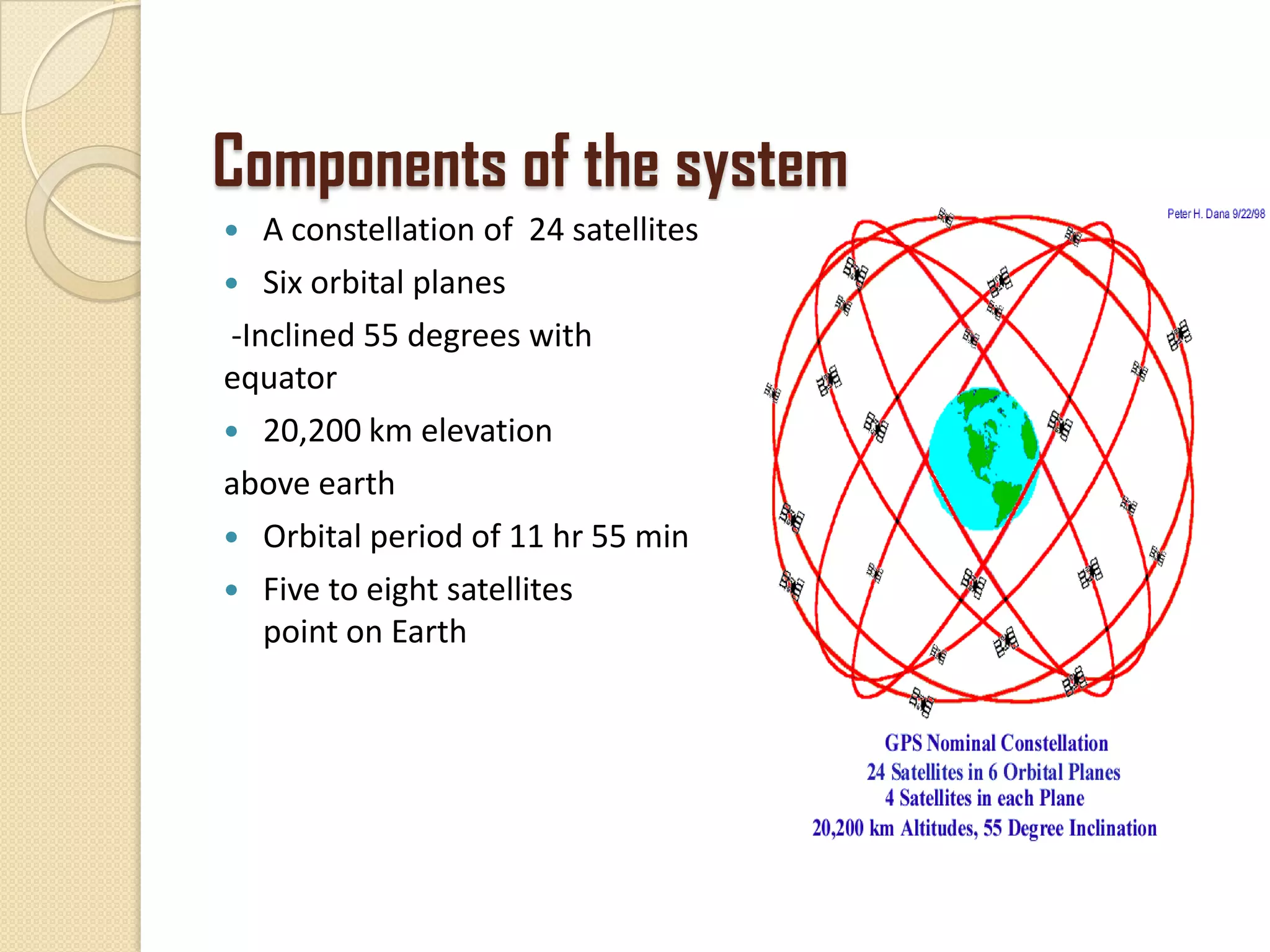
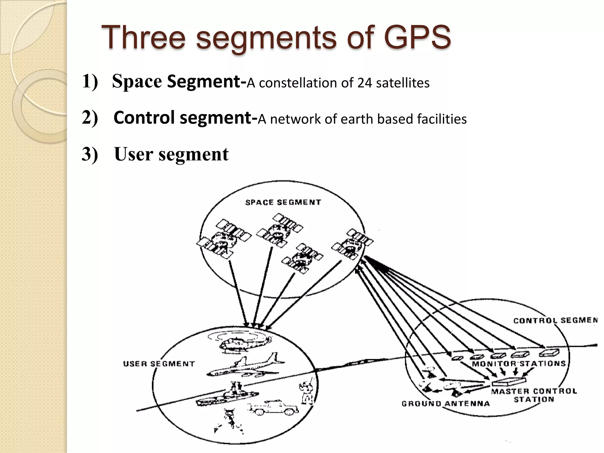
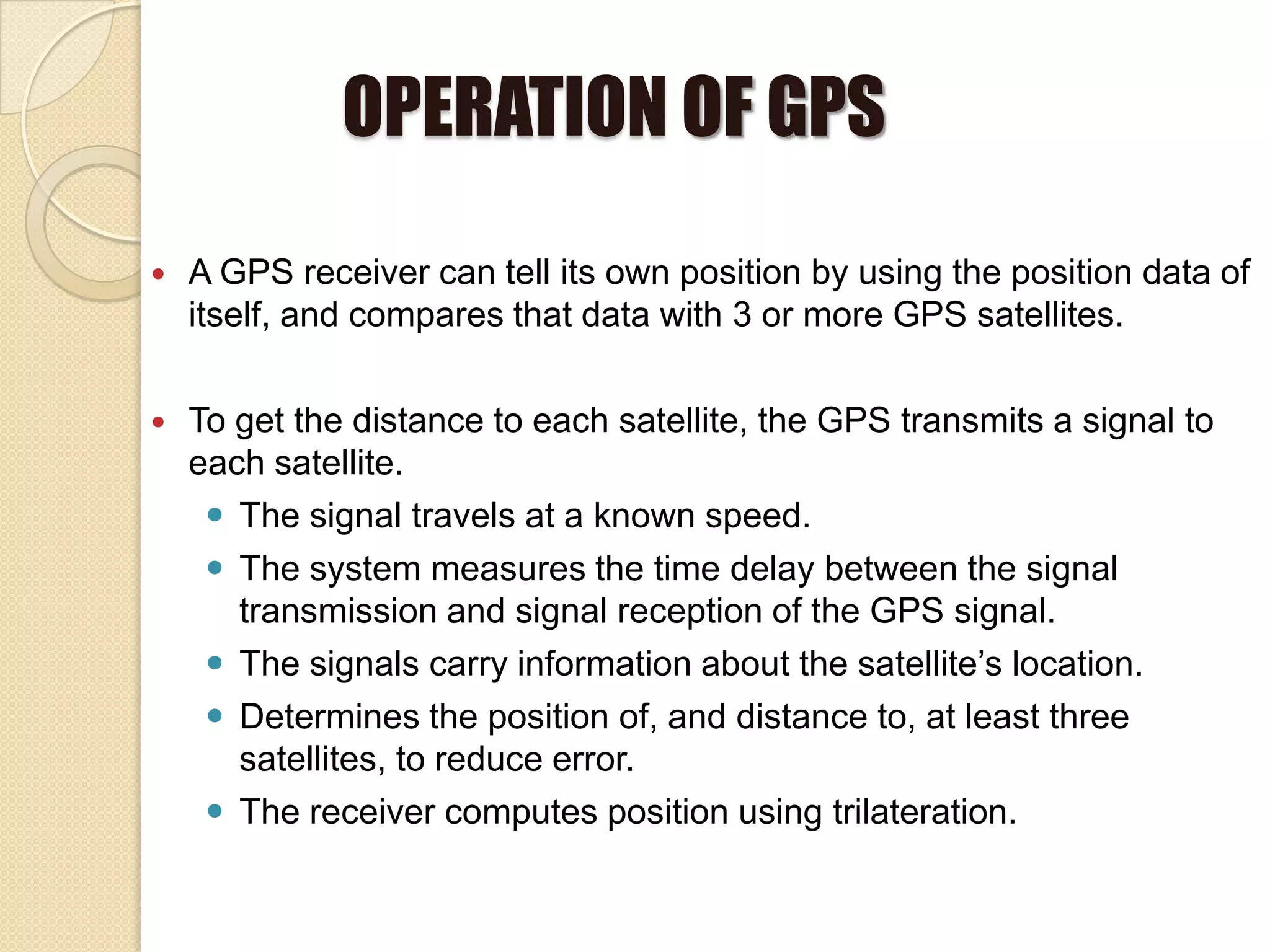
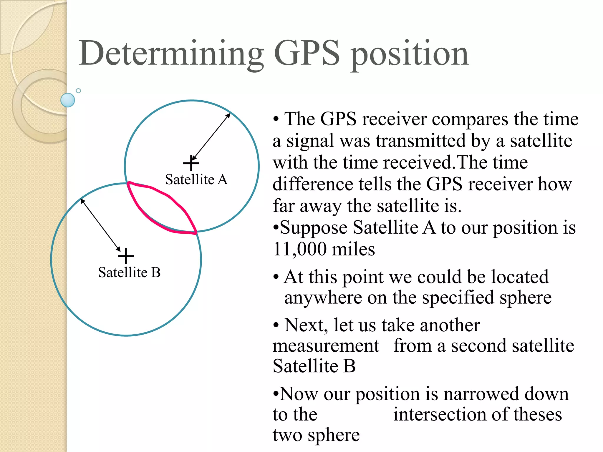
• The Global Positioning System (GPS) is a space-based Global
navigation satellite system that provides location and time information.
• The project was started in 1973 to overcome the limitations of previous
navigation systems.
• GPS was created by the US department of defence and was originally
run with 24 satellites.
• Since 1994 the Global Positioning System has been available for civilian
use at no cost.
• Freely accessible by anyone with a GPS receiver.
• Main functions : Position and coordinates, Travel progress
reports, Accurate time measurement.
The need for positioning system
 Department of Defense were facing challenges to increase
security of the US.
During emergencies we require immediate tracking of
important people.
Logistic companies need tracing of their fleet for reliable
operations.
Personal valuables vehicles and goods when stolen or lost
were not easier to locate.
Components of the system
 A constellation of 24 satellites
 Six orbital planes
-Inclined 55 degrees with respect to
equator
 20,200 km elevation
above earth
 Orbital period of 11 hr 55 min
 Five to eight satellites visiblefrom any
point on Earth
Three segments of GPS
1) Space Segment-A constellation of 24 satellites
2) Control segment-A network of earth based facilities
3) User segment
OPERATION OF GPS
 A GPS receiver can tell its own position by using the position data of
itself, and compares that data with 3 or more GPS satellites.
 To get the distance to each satellite, the GPS transmits a signal to
each satellite.
 The signal travels at a known speed.
 The system measures the time delay between the signal
transmission and signal reception of the GPS signal.
 The signals carry information about the satellite’s location.
 Determines the position of, and distance to, at least three
satellites, to reduce error.
 The receiver computes position using trilateration.
Determining GPS position
• The GPS receiver compares the time
a signal was transmitted by a satellite
with the time received.The time
difference tells the GPS receiver how
far away the satellite is.
•Suppose Satellite A to our position is
11,000 miles
• At this point we could be located
anywhere on the specified sphere
• Next, let us take another
measurement from a second satellite,
Satellite B
•Now our position is narrowed down
to the intersection of theses
two sphere
Satellite A
+
Satellite B
+
Satellite C
+
Determining GPS Position
Satellite A
Satellite B
+
+
•Taking another measurement from a 3rd
satellite narrows our position down even
further, to the two points
• These points are located where the 3rd
sphere cuts through the intersection of first
two spheres
•So by ranging from 3 satellites we can
narrow our position to just two points in
space
•We could make a 4th measurement from
another satellite to determine the true point
•However, GPS receivers use a 4th satellite
to precisely locate our position
Applications
 Military:
- Search and rescue missions
- Digital Assistant for soldiers
(personal navigation)
- Detect nuclear detonation with sensors on satellites
someone explode a nuclear weapon, the GPS system can find the
position by equiping it with sensors.
 Civilian:
- Used in map-making and land surveying
- Outdoor Activities (Hike/bike trails, GeoCaching)
- Various usages in many fields of industry
- Vehicle navigation (for cars, airplanes, and ships)
- Use GPS to determine position, speed, and direction
Limitations and drawbacks
 A stolen object can’t be traced out if Receiver is switched off or facing
power failure.
 Low batteries may reduce receiver sensitivity.
 Position of the receiver can’t be traced if kept under high EM
insulation.
 It requires a minimum of 4-5 satellites in order to give accurate
locations.
 Causes problem when the sky is obscured by canyon walls, mountains, or
tall buildings.
 Atmospheric conditions like geomagnetic storms makes it less accurate
Future of GPS
 Automobiles are tested on moving on their own without
the assistance of a driver.
 Tests have begun in using unmanned aircrafts.
 GPS has truly helped man to advance in more ways than
one.
 It is also going to bring a great revolution by its
development.
References
 http://en.wikipedia.org/wiki/Global_Positioning_System
 http://electronics.howstuffworks.com/gadgets/travel/gps.htm
 http://en.wikipedia.org/wiki/GPS_navigation_device
 http://www.ehow.com/about_5730112_objectives-global-
positioning-system.html
 http://www.ehow.com/about_6595713_purpose-gps-system-
started.html
 http://www.webmapsolutions.com/future-developments-gps-
technology

Global positioning system (GPS)

  • 1.
    Global positioning system By K.GauthamReddy 2011A8ps364g By K.Gautham Reddy 2011A8PS364G
  • 2.
    Introduction • The GlobalPositioning System (GPS) is a space-based Global navigation satellite system that provides location and time information. • The project was started in 1973 to overcome the limitations of previous navigation systems. • GPS was created by the US department of defence and was originally run with 24 satellites. • Since 1994 the Global Positioning System has been available for civilian use at no cost. • Freely accessible by anyone with a GPS receiver. • Main functions : Position and coordinates, Travel progress reports, Accurate time measurement.
  • 3.
    The need forpositioning system  Department of Defense were facing challenges to increase security of the US. During emergencies we require immediate tracking of important people. Logistic companies need tracing of their fleet for reliable operations. Personal valuables vehicles and goods when stolen or lost were not easier to locate.
  • 4.
    Components of thesystem  A constellation of 24 satellites  Six orbital planes -Inclined 55 degrees with respect to equator  20,200 km elevation above earth  Orbital period of 11 hr 55 min  Five to eight satellites visiblefrom any point on Earth
  • 5.
    Three segments ofGPS 1) Space Segment-A constellation of 24 satellites 2) Control segment-A network of earth based facilities 3) User segment
  • 6.
    OPERATION OF GPS A GPS receiver can tell its own position by using the position data of itself, and compares that data with 3 or more GPS satellites.  To get the distance to each satellite, the GPS transmits a signal to each satellite.  The signal travels at a known speed.  The system measures the time delay between the signal transmission and signal reception of the GPS signal.  The signals carry information about the satellite’s location.  Determines the position of, and distance to, at least three satellites, to reduce error.  The receiver computes position using trilateration.
  • 7.
    Determining GPS position •The GPS receiver compares the time a signal was transmitted by a satellite with the time received.The time difference tells the GPS receiver how far away the satellite is. •Suppose Satellite A to our position is 11,000 miles • At this point we could be located anywhere on the specified sphere • Next, let us take another measurement from a second satellite, Satellite B •Now our position is narrowed down to the intersection of theses two sphere Satellite A + Satellite B +
  • 8.
    Satellite C + Determining GPSPosition Satellite A Satellite B + + •Taking another measurement from a 3rd satellite narrows our position down even further, to the two points • These points are located where the 3rd sphere cuts through the intersection of first two spheres •So by ranging from 3 satellites we can narrow our position to just two points in space •We could make a 4th measurement from another satellite to determine the true point •However, GPS receivers use a 4th satellite to precisely locate our position
  • 9.
    Applications  Military: - Searchand rescue missions - Digital Assistant for soldiers (personal navigation) - Detect nuclear detonation with sensors on satellites someone explode a nuclear weapon, the GPS system can find the position by equiping it with sensors.  Civilian: - Used in map-making and land surveying - Outdoor Activities (Hike/bike trails, GeoCaching) - Various usages in many fields of industry - Vehicle navigation (for cars, airplanes, and ships) - Use GPS to determine position, speed, and direction
  • 10.
    Limitations and drawbacks A stolen object can’t be traced out if Receiver is switched off or facing power failure.  Low batteries may reduce receiver sensitivity.  Position of the receiver can’t be traced if kept under high EM insulation.  It requires a minimum of 4-5 satellites in order to give accurate locations.  Causes problem when the sky is obscured by canyon walls, mountains, or tall buildings.  Atmospheric conditions like geomagnetic storms makes it less accurate
  • 11.
    Future of GPS Automobiles are tested on moving on their own without the assistance of a driver.  Tests have begun in using unmanned aircrafts.  GPS has truly helped man to advance in more ways than one.  It is also going to bring a great revolution by its development.
  • 12.
    References  http://en.wikipedia.org/wiki/Global_Positioning_System  http://electronics.howstuffworks.com/gadgets/travel/gps.htm http://en.wikipedia.org/wiki/GPS_navigation_device  http://www.ehow.com/about_5730112_objectives-global- positioning-system.html  http://www.ehow.com/about_6595713_purpose-gps-system- started.html  http://www.webmapsolutions.com/future-developments-gps- technology