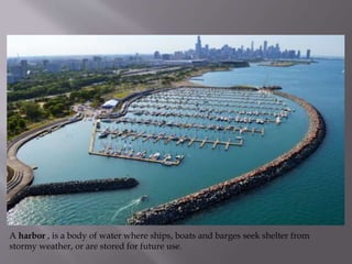
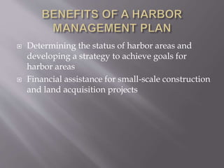
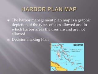
Present By
I.Joshua Andrew
I MBA-Environmental Management
Bharathidasan Univerisity
A harbor , is a body of water where ships, boats and barges seek shelter from
stormy weather, or are stored for future use.
 Every harbor on the sea-coast, also, has its bar
at its entrance.

The largest artificially created harbor is Jebel
Ali in Dubai
 The oldest artificial harbor known is the
Ancient Egyptian
 Uses of harbors, between recreational and
commercial activities, and between all uses and
natural and cultural resources.
 Harbor management plans are to be
undertaken as part of a Local Waterfront
Revitalization Program (LWRP
 Determining the status of harbor areas and
developing a strategy to achieve goals for
harbor areas
 Financial assistance for small-scale construction
and land acquisition projects
 A Harbor management plan would consist of
the "wet side" components of the following
LWRP sections
 A harbor management plan and its
implementing local laws effectively zone
surface water areas and underwater lands for
specific uses or a range of specific uses in order
to avoid conflicts or improve conditions within
harbor or near shore areas.
 Implement Land Improvement Plan
 Problems related to dredging and dredged
material disposal
 Need to protect important water-dependent
uses in appropriate areas within the Harbor
 Through Harbor Management
“Redevelopment” of underutilized or
deteriorated areas for projects that advance
Harbor management efforts
 Municipality's corporate limits extend
more than 1500 feet from the shore, the
map should indicate that the waterward
limits of the municipality’s harbor
management area coincide with the
waterward limits of the municipality's
corporate limits
 where the shore is generally even, the 1500 feet
is measured, from the mean low water line
 where the shore is uneven because of
indentations such as coves, small bays, inlets or
similar conditions, the 1500 feet is measured
from a straight line ,drawn across the
indentation from the two points representing
the furthest water ward extent of the mean low
water line on either side of the indentation .
 where an offshore island is part of a mainland
municipality, and the municipality's corporate
limits do not encompass the water area
between the mainland and the island or
surrounding the island, “the 1500 feet distance
from the shore of the island is measured from
the mean low water line surrounding the
island”
 The harbor management plan map is a graphic
depiction of the types of uses allowed and in
which harbor areas the uses are and are not
allowed .
 Decision making Plan
 Harbor management plans will be reviewed
and approved by the Secretary of State in the
same manner as a LWRP or an amendment to a
LWRP
 Harbor Management Area
 Perimeter Area
 Water-dependent Use-
 Effective management of port and harbour
infrastructure requires expert knowledge of the
relevant environmental cause-effect pathways
 sewage handling and treatment are chiefly
responsible for continued improvements to
water quality
 We can Preserve the water quality, trades for
commercial activities.
Presentation harbor management

Presentation harbor management

  • 1.
    Present By I.Joshua Andrew IMBA-Environmental Management Bharathidasan Univerisity
  • 3.
    A harbor ,is a body of water where ships, boats and barges seek shelter from stormy weather, or are stored for future use.
  • 4.
     Every harboron the sea-coast, also, has its bar at its entrance.  The largest artificially created harbor is Jebel Ali in Dubai  The oldest artificial harbor known is the Ancient Egyptian
  • 7.
     Uses ofharbors, between recreational and commercial activities, and between all uses and natural and cultural resources.  Harbor management plans are to be undertaken as part of a Local Waterfront Revitalization Program (LWRP
  • 8.
     Determining thestatus of harbor areas and developing a strategy to achieve goals for harbor areas  Financial assistance for small-scale construction and land acquisition projects
  • 9.
     A Harbormanagement plan would consist of the "wet side" components of the following LWRP sections  A harbor management plan and its implementing local laws effectively zone surface water areas and underwater lands for specific uses or a range of specific uses in order to avoid conflicts or improve conditions within harbor or near shore areas.  Implement Land Improvement Plan
  • 10.
     Problems relatedto dredging and dredged material disposal  Need to protect important water-dependent uses in appropriate areas within the Harbor
  • 11.
     Through HarborManagement “Redevelopment” of underutilized or deteriorated areas for projects that advance Harbor management efforts
  • 13.
     Municipality's corporatelimits extend more than 1500 feet from the shore, the map should indicate that the waterward limits of the municipality’s harbor management area coincide with the waterward limits of the municipality's corporate limits
  • 14.
     where theshore is generally even, the 1500 feet is measured, from the mean low water line
  • 15.
     where theshore is uneven because of indentations such as coves, small bays, inlets or similar conditions, the 1500 feet is measured from a straight line ,drawn across the indentation from the two points representing the furthest water ward extent of the mean low water line on either side of the indentation .
  • 16.
     where anoffshore island is part of a mainland municipality, and the municipality's corporate limits do not encompass the water area between the mainland and the island or surrounding the island, “the 1500 feet distance from the shore of the island is measured from the mean low water line surrounding the island”
  • 17.
     The harbormanagement plan map is a graphic depiction of the types of uses allowed and in which harbor areas the uses are and are not allowed .  Decision making Plan
  • 18.
     Harbor managementplans will be reviewed and approved by the Secretary of State in the same manner as a LWRP or an amendment to a LWRP
  • 19.
     Harbor ManagementArea  Perimeter Area  Water-dependent Use-
  • 20.
     Effective managementof port and harbour infrastructure requires expert knowledge of the relevant environmental cause-effect pathways  sewage handling and treatment are chiefly responsible for continued improvements to water quality  We can Preserve the water quality, trades for commercial activities.