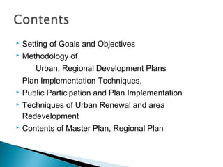
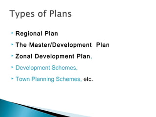
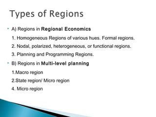
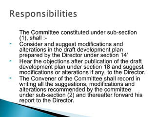
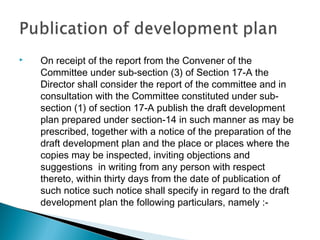
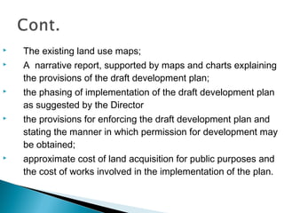
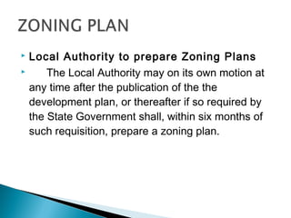
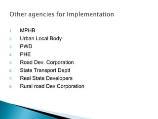
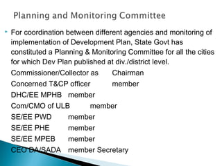
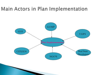
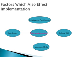
The document discusses various aspects of regional and urban planning such as defining regions, delineating regions, preparing regional plans, development plans and zoning plans. It outlines the process of setting goals and objectives, preparing draft plans, inviting public participation, addressing objections and modifying plans. It also describes different agencies and mechanisms involved in plan implementation such as development authorities, urban local bodies and various state departments. Coordination between agencies and monitoring of implementation is done through planning committees. Political will, public awareness, real estate developers and existing legislation also influence effective plan implementation.
A master plan or a development plan or a town plan may be
defined as a
general plan for the future layout of a city showing both the existing and
proposed streets or roads, open spaces, public buildings etc. A master
plan is prepared either for improvement of an old city or for a new
town to be developed on a virgin soil. A master plan is a blueprint for the
future. It is an comprehensive document, long-range in its view, that
is intended to guide development in the
township for the next 10 to 20 years.
An urban area is characterized by higher population density and vast human features in comparison to areas surrounding it. Urban areas may be cities, towns or conurbations, but the term is not commonly extended to rural settlements such as villages. Any portion of earth’s surface where physical conditions are homogeneous can be considered as a Region in geographic sense, ranging from a single feature region to compage, depending on the
criteria used for delineation. In practice, a prefix is added to highlight the attributes on which the region has been defined, for example, agriculture region, resource region, city region, planning region.
All the daily activities of human beings are carried out on land. Proper organization of these activities i.e. planning will help the human being in leading a richer and fuller life in livable surroundings or environment. "Planning" means the scientific, aesthetic, and orderly disposition of land, resources, facilities and services with a view to securing the physical, economic and social efficiency, health and well-being of urban and rural communities.
A development plan is an aspect of town and country planning in the United Kingdom comprising a set of documents that set out the local authority's policies and proposals for the development and use of land in their area.
town development plan
child development ppt
people development ppt
human development ppt
language development ppt
implementation plan ppt
curriculum development ppt
project plan ppt template
Singapore, officially the Republic of Singapore, is a sovereign island city-state in Southeast Asia.
It is located at the end of the Malayan Peninsula between Malaysia and Indonesia.
Singapore has a total land area of 724.2 square kilometers.
Singapore's territory consists of one main island along with 58 other islets.
Since independence[1965], extensive land reclamation has increased its total size by 23%.
Singapore is very small in size and confined. so, there every sq. meter matters.
Now, 90% of citizens in Singapore own their houses.
Urban planning in Singapore has formulated and guided its physical development from the day Singapore was founded in 1819 as a British colony to the developed, independent country it is today.
Urban planning is especially important due to land constraints and its high density.
The Urban Redevelopment Authority (URA) is Singapore's national land-use planning authority.
URA prepares long term strategic plans, as well as detailed local area plans, for physical development, and then co-ordinates and guides efforts to bring these plans to reality.
Prudent land use planning has enabled Singapore to enjoy strong economic growth and social cohesion, and ensures that sufficient land is safeguarded to support continued economic progress and future development
In 1822, Raffles initiated a comprehensive town plan called land use plan.
This plan to guide the allocation of land in the principal town to ensure that its physical growth followed an orderly pattern.
This became known as the Raffles Town Plan, or the Jackson Plan, drawn up by Lieutenant Philip Jackson and published in 1828.
Among its key features were a GRID LAYOUT for the road network and a clear segregation of residential communities by ethnic group (European, Chinese, Indian, Malay and Arab).
A separate area called Commercial Square (later renamed Raffles Place) was designated for commercial activities and another area was zoned for government functions.
Raffles Place and the street pattern of the city Centre
today are evidence of this colonial legacy.
History of Town Planning_Building and Town PlanningA Makwana
The term town planning is used to indicate the arrangement of various components of a town in such a way that the town as such attains the significance of a living organism.
Development control rules,
Maharashtra Regional Town Planning Act,
Land acquisition act,
Village planning: Necessity and principles,
Rural developments- Growth
centre approach, Area Development approach, Integrated rural development
approach.
Local policies and strategies designed to deal with urban decline, decay or transformation are termed as urban renewal.
It is a comprehensive and integrated vision and action which leads to the resolution of urban problems and which seeks to bring about a lasting improvement in the economic, physical, social and environmental conditions of an area that has been subject to change’
With the decision and authority of a governing municipality, rearranging land use, function and ownership features of a socially, economically or structurally decayed part of a certain city .
such as slum zones or brown fields, for the purpose of obtaining a desired, well organized neighbourhood.
presentation based on Land Acquisition act and Land pooling in India. PPT is helpful for Urban Planning Students. discussed various land pooling models in India.
Development control rules,
Maharashtra Regional Town Planning Act,
Land acquisition act,
Village planning: Necessity and principles,
Rural developments- Growth
centre approach, Area Development approach, Integrated rural development
approach.
Growth pattern of towns Natural and Planned,
Types of zoning and importance,
various road networks(Grid iron pattern, shoe string development,
Surveys for data collection, physical survey, social survey, economic survey, civic survey,
Town aesthetics, landscape architecture,
Rehabilitation of slum and urban renewal,
he MRTP Act was enacted to ensure that the economic system’s operation does not result in the concentration of economic power in the hands of a few. An overview of the MRTP Act has been provided in this article, covering key characteristics, key clauses, and revisions that have been made throughout time. It was eventually abolished and replaced by the Competition Act of 2002, India’s first market regulation law.
The Monopolistic and Restrictive Trade Practices Legislation (MRTP) was implemented in 1969. This law was designed to ensure that the economic system’s operation does not result in the concentration of economic power in the hands of a few. Therefore, ensure that monopolies are controlled and that monopolistic and restrictive business practices are prohibited. Except for Jammu & Kashmir, the MRTP Act covers the whole country.
The MRTP Act was passed in 1969 to ensure that economic power was concentrated in the hands of a few wealthy individuals. The statute was put in place to prevent monopolistic and restrictive business practices. Except for Jammu and Kashmir, it covered all of India.
The act’s Goals and Objectives are as follows
To ensure that the economic system does not result in the concentration of economic power in the hands of a few wealthy individuals
To ensure that monopolies are controlled, and
To make it illegal to engage in monopolistic and restrictive commercial practices
The Act shall not apply to the following
Any venture that the government firm owns or controls
Any government-owned or controlled enterprise
Any undertaking owned or managed by a corporation (not one formed by or under any federal, provincial, or state law)
Any trade union or other group of workers or employees created to ensure their reasonable protection as workers or employees
Any industry-related activity whose administration has been taken over by a person or group of people with powers granted by the central government
Any business owned by a cooperative society created and registered by federal, provincial, or state law
Unfair Trade Practices
Unfair business practice Means a business practice that employs a dishonest or misleading practice to promote the sale, usage, or supply of products or services.
What are unfair trading practices?
Falsely implies that the items are of a certain quality, quantity, grade, composition, or model style
Make a false claim that the service meets a certain standard, quantity, or grade
Represents sponsorship, approval, performance, traits, accessories, uses, or benefits that the items or services do not have
Makes a false or deceptive statement about the necessity for, or utility of, any products or services
It gives any promise or assurance about the items’ performance, efficiency, or life span that isn’t based on appropriate or proper testing
False offer of bargaining price: It is unfair commercial conduct if an advertisement is published in a newspaper or elsewhere offering products or services at a bargain price
Land use and building control as a tool for implementation of master plan and...Dolat Ram
This presentation will help you understand the importance of land use and building control and its role in implementation of master plan and other local plans.
Final Guidelines in the 6 UN languages (Arabic, Chinese, English, French, Spa...Graciela Mariani
UN-Habitat Governing Council approves the International Guidelines on Urban and Territorial Planning (IG-UTP)
We are pleased to inform you that the International Guidelines on Urban and Territorial Planning have been approved by the UN-Habitat Governing Council last Friday.
We are grateful for the instrumental support of the co-sponsors of the Resolution (France, Japan, South Africa and Uganda)….
We attach here some relevant documents (also available on-line at http://unhabitat.org/gc25/) that we encourage you to use and share with your constituencies, partners and professional networks:
1. Resolution 25/L5 that approves the Guidelines and gives a mandate for their implementation and monitoring.
2. Press Release that you may wish to adapt and disseminate as appropriate.
3. Final Guidelines in the 6 UN languages (Arabic, Chinese, English, French, Spanish, Russian): currently being put in a proper lay-out for outreach and communication purposes.
4. Compendium of Inspiring Practices: sample of an on-going, larger and open initiative to document inspirational and international experiences on Urban and Territorial Planning that illustrates the Guidelines….
We will continue to explore…avenues to inform global and regional agendas as well as country operations. An immediate activity could be to translate the Guidelines in other languages (eg: Portuguese, Indonesian...) for broader outreach and impacts. We are open to suggestions and count very much on your feedback and active participation….
We thank you for your continuous engagement and commitment. We look forward to keeping you with us in this exciting IG-UTP journey.
1. INTRODUCTION TO SUBJECT ITP
2. DEFINITION OF INTRODUCTION TO PLANNING ITP
3. AIMS AND OBJECTIVES OF URBAN PLANNING
a. ELOBRATIONS
4. TERMS USED IN PLANNING AND THEIR DEFINITION
5. RELATIONSHIP OF CRP WITH OTHER FIELDS
a. RELATIONSHIP WITH ARCHITECHTURE
b. RELATIONSHIP WITH CIVIL ENGINEERING
c. RELATIONSHIP WITH ENVIRONMENTAL ENGINEERING
d. RELATIONSHIP WITH SURVYING
e. RELATIONSHIP WITH LANDSCAPE ARCHITECHTURE
f. RELATIONSHIP WITH SOCIOLOGY
g. RELATIONSHIP WITH ECONOMICS
6. IMPORTANCE OF URBAN PLANNING
7. FUNCTIONS OF PROFESSIONAL PLANNER
8. NEW TRENDS IN PLANNING
9. GEOGRPHICAL TOPOGRAPHICAL AND CLIMATIC CONDITIONS IN RELATION TO PLANNING
10. JUSTIFICATIONS FOR PLANNING
11. PRINCIPLES OF PLANNING
12. LEVELS AND ELEMENTS OF PLANNING
13. LAND USE PLANNING THEORY OF SIR PATRICK GEDDES
14. LAND USE PLANNING THEORY OF SIR EBNEZIR HOWARD
15. LAND USE PLANNING THEORY OF LE COUBISER
16. LAND USE PLANNING THEORY OF FRANK LOYD WRIGHT
17. LAND USE PLANNING THEORY OF LEWIS MUMFORD
18. LAND USE PLANNING THEORY OF C.A DOXIADIS
Let’s take a look at some of the most common Space and Facility Management terms and review what they mean so you can be sure to stay ahead of the curve as you plan moves, manage employees, carry out a successful space inventory and space utilization of the additional space and facilities in your office.
osha underground utilities standard
what utilities service my address
dallas water utilities standard details
dallas water utilities standards
dallas water utilities standard drawings
Rational Planning concepts and relation with the sustainable concepts is explained with appropriate detail case studies from over the world. Indian scenario is then over-viewed..
Kevyn introduced a concept of planning that was the base for understanding and visualising The Planning Aspects; important for the budding planners.
The presentation initiates the same understanding and invokes a means for better understanding of 'Planning'.
In context of India n comparing it with the world. The presentation defines these concepts with apt case studies from various countries and India as well..
Instructions for Submissions thorugh G- Classroom.pptxJheel Barad
This presentation provides a briefing on how to upload submissions and documents in Google Classroom. It was prepared as part of an orientation for new Sainik School in-service teacher trainees. As a training officer, my goal is to ensure that you are comfortable and proficient with this essential tool for managing assignments and fostering student engagement.
The Indian economy is classified into different sectors to simplify the analysis and understanding of economic activities. For Class 10, it's essential to grasp the sectors of the Indian economy, understand their characteristics, and recognize their importance. This guide will provide detailed notes on the Sectors of the Indian Economy Class 10, using specific long-tail keywords to enhance comprehension.
For more information, visit-www.vavaclasses.com
Operation “Blue Star” is the only event in the history of Independent India where the state went into war with its own people. Even after about 40 years it is not clear if it was culmination of states anger over people of the region, a political game of power or start of dictatorial chapter in the democratic setup.
The people of Punjab felt alienated from main stream due to denial of their just demands during a long democratic struggle since independence. As it happen all over the word, it led to militant struggle with great loss of lives of military, police and civilian personnel. Killing of Indira Gandhi and massacre of innocent Sikhs in Delhi and other India cities was also associated with this movement.
The Art Pastor's Guide to Sabbath | Steve ThomasonSteve Thomason
What is the purpose of the Sabbath Law in the Torah. It is interesting to compare how the context of the law shifts from Exodus to Deuteronomy. Who gets to rest, and why?
How to Split Bills in the Odoo 17 POS ModuleCeline George
Bills have a main role in point of sale procedure. It will help to track sales, handling payments and giving receipts to customers. Bill splitting also has an important role in POS. For example, If some friends come together for dinner and if they want to divide the bill then it is possible by POS bill splitting. This slide will show how to split bills in odoo 17 POS.
We all have good and bad thoughts from time to time and situation to situation. We are bombarded daily with spiraling thoughts(both negative and positive) creating all-consuming feel , making us difficult to manage with associated suffering. Good thoughts are like our Mob Signal (Positive thought) amidst noise(negative thought) in the atmosphere. Negative thoughts like noise outweigh positive thoughts. These thoughts often create unwanted confusion, trouble, stress and frustration in our mind as well as chaos in our physical world. Negative thoughts are also known as “distorted thinking”.
The Roman Empire A Historical Colossus.pdfkaushalkr1407
The Roman Empire, a vast and enduring power, stands as one of history's most remarkable civilizations, leaving an indelible imprint on the world. It emerged from the Roman Republic, transitioning into an imperial powerhouse under the leadership of Augustus Caesar in 27 BCE. This transformation marked the beginning of an era defined by unprecedented territorial expansion, architectural marvels, and profound cultural influence.
The empire's roots lie in the city of Rome, founded, according to legend, by Romulus in 753 BCE. Over centuries, Rome evolved from a small settlement to a formidable republic, characterized by a complex political system with elected officials and checks on power. However, internal strife, class conflicts, and military ambitions paved the way for the end of the Republic. Julius Caesar’s dictatorship and subsequent assassination in 44 BCE created a power vacuum, leading to a civil war. Octavian, later Augustus, emerged victorious, heralding the Roman Empire’s birth.
Under Augustus, the empire experienced the Pax Romana, a 200-year period of relative peace and stability. Augustus reformed the military, established efficient administrative systems, and initiated grand construction projects. The empire's borders expanded, encompassing territories from Britain to Egypt and from Spain to the Euphrates. Roman legions, renowned for their discipline and engineering prowess, secured and maintained these vast territories, building roads, fortifications, and cities that facilitated control and integration.
The Roman Empire’s society was hierarchical, with a rigid class system. At the top were the patricians, wealthy elites who held significant political power. Below them were the plebeians, free citizens with limited political influence, and the vast numbers of slaves who formed the backbone of the economy. The family unit was central, governed by the paterfamilias, the male head who held absolute authority.
Culturally, the Romans were eclectic, absorbing and adapting elements from the civilizations they encountered, particularly the Greeks. Roman art, literature, and philosophy reflected this synthesis, creating a rich cultural tapestry. Latin, the Roman language, became the lingua franca of the Western world, influencing numerous modern languages.
Roman architecture and engineering achievements were monumental. They perfected the arch, vault, and dome, constructing enduring structures like the Colosseum, Pantheon, and aqueducts. These engineering marvels not only showcased Roman ingenuity but also served practical purposes, from public entertainment to water supply.
How to Create Map Views in the Odoo 17 ERPCeline George
The map views are useful for providing a geographical representation of data. They allow users to visualize and analyze the data in a more intuitive manner.
The French Revolution, which began in 1789, was a period of radical social and political upheaval in France. It marked the decline of absolute monarchies, the rise of secular and democratic republics, and the eventual rise of Napoleon Bonaparte. This revolutionary period is crucial in understanding the transition from feudalism to modernity in Europe.
For more information, visit-www.vavaclasses.com
The French Revolution Class 9 Study Material pdf free download
Plan preparation techniques
1.
2.
Setting of Goals and Objectives
Methodology of
Urban, Regional Development Plans
Plan Implementation Techniques,
Public Participation and Plan Implementation
Techniques of Urban Renewal and area
Redevelopment
Contents of Master Plan, Regional Plan
4.
Definition
A region is a sub-system within a system (the
country itself) and if sub-systems develop greater
inter-connectivity, the greater will be the efficiency
of the system.
5.
A) Regions in Regional Economics
1. Homogeneous Regions of various hues. Formal regions.
2. Nodal, polarized, heterogeneous, or functional regions.
3. Planning and Programming Regions.
B) Regions in Multi-level planning
1.Macro region
2.State region/ Micro region
4. Micro region
6.
C) Regions in in the ‘stages-of-development’ analysis
1. Developed Region
2. Backward and Depressed Region (Vestigial regions also)
3. Neutral and Intermediate Regions.
D) Regions as per the activity status analysis
1. Mineral regions
2. Manufacturing regions
3. Urban and or Congested regions
7.
The hierarchy of planning region
(i) national level
(ii) macro level
(iii) state level
(iv) meso level
(v) and micro level
8.
Establishment of Regions/Delineation
The State Government may, by notification
a) Declare any area in the State to be a region for the purposes of this
Act.
b) Define the limits of such area; and
c) Specify the name by which such region shall be known.
The State Government may, by notification alter the name of any such region and on such
alteration, any reference in any law or instrument or other document to the region
shall
be deemed to be reference to the region as renamed, unless expressly otherwise provided or the
context so required
9. The Regional plan shall indicate the manner in which land in
the region should be used, the phasing of development, the
net work of communications and transport, the proposals for
conservation and development of natural resources, and in
particular –
a) allocation of land to such purposes as residential,
industrial, agricultural or as forests or for mineral exploitation;
b) reservation of open spaces for recreational purposes,
gardens, tree belts and animal sanctuaries;
c) access or development of transport and communication
facilities such as roads, railways, water ways and the location
and development of airports;
10. d) requirements and suggestions for development of public
utilities such as water supply, drainage and electricity;
e) allocation of areas to be developed as ‘ special areas’,
wherein new towns, township, large industrial estates or
any other type of large development projects may be
established.
f) Landscaping and the preservation of areas in their
natural state;
g) Measures relating to the prevention of erosion, including
rejuvenation of forest areas;
h) Proposals relating to irrigation, water supply or flood
control works..
11.
After preparation of the existing land use map, the
Director shall cause to be prepared a draft
regional plan and publish it by making a copy
thereof available for inspection and publishing a
notice in such form and manner as may be
prescribed inviting objections and suggestions
from any person with respect to the draft plan
before such date as may be specified in the
notice, such date not being earlier than sixty days
from the publication of the notice.
12.
The Director shall consider all the objections and
suggestions received by him within the period
specified in the notice under sub-section (1) and
shall after giving a reasonable opportunity to all
persons affected thereby of being heard prepare
the regional plan containing such modifications,
if any, as the considers necessary and submit it
to the State Government for approval together
with all connected documents, plans, maps and
charts.
13. The state government may approve the draft regional
plan submitted under section 8 with or without
modification or reject or return the sameto the Director
for reconsideration.
14. Cities are probably the most complex things that
human beings have ever created.
They are the wellsprings of culture, technology,
wealth and power.
People have a love-hate relationship with cities.
We are torn between our needs for community
and privacy and the conflicting attractions of urban
and rural life.
15.
Urban Planning can be defined as the design and
regulation of the uses of space that focus on the
physical form, economic functions, and social
impacts of the urban environment and on the
location of different activities within it.
16.
The need of the hour is sustainable development.
With increasing population and growing pollution, we
can’t ignore the ill effects of planning on the
environment.
Sustainable development refers to:o Utilising the present resources keeping in mind the
future needs of the society, so as not to exhaust the
resources.
o It should not disturb the ecological cycle and hence
preserve the environment.
17.
Protect natural environment.
Conservation of areas of cultural heritage.
Optimize land use and land utilization
Provide services and infrastructure
Participatory approach for supply of land and infrastructure
development.
Urban planning is basically resource generation, resource
development and resource management exercise. The
efficiency of urban settlements largely depends upon how
well they are planned, how economically they are
developed and how efficiently they are managed
18. The State Government may by notification constitute planning
areas for the purposes of this Act and define the limits thereof.
The State Government may, by notification –
a) alter the limits of the planning area, so as to include
therein or exclude therefrom such area as may be
specified in the notification;
b) amalgamate two or more planning areas so as to
constitute one planning area
c) divide any planning area into two or more planning
areas
d) declare that the whole or part of the area constituting
the planning area shall cease to be a planning area or
part thereof
19.
The Director shall carry out the survey and prepare an
existing land use map and forthwith public the same in such
manner as may be prescribed together with public notice of
the preparation of the map and of place or places where
the copies may be inspected, inviting objections and
suggestions in writing from any person with respect thereto
within thirty days from the date of publication of such notice.
After the expiry of the period specified in the notice
published under sub-section (1) the Director may, after
allowing a reasonable opportunity of being heard to all such
persons who have filed the objections or suggestions, make
such modifications therein as may be considered desirable.
20.
on the publication of the existing land use map
under section 15 –
no person shall institute or change the use of
any land or carry out any development of land
for any purpose other than that indicated in the
existing land use map without the permission in
writing of the Director:
21.
A development plan shall take into account any
draft five year plan and Annual Development plan
of the district, in which the planning area is
situated and shall :
◦ indicate broadly the land use proposed in the planning
area;
22. • Project the requirement of the planning area
of such amenities and utilities as water,
drainage, electricity and suggest their
fulfillment.
• Propose broad based regulations for zoning,
by way of guide lines, within each zone or
sector of the location, height, size of buildings
and structures, open spaces, court yards and
the use to which such buildings and structures
and land may be put;
23. • Lay down the broad based traffic circulation
patterns in a city’
• Suggest architectural control features;
elevation and frontages of buildings and
structures;
• Indicate measures for flood control,
prevention of air and water pollution,
disposal of garbage and general
environmental control.
24. Under Section 17A of T&CP act There is a Provision of
Constitution of committee comprising of Mayor/President
of ulb’s,MP,MLA,Chairman DA,President Janpad
Panchyats,
Sarpanchs and seven members nominated by govt of
specific fields to
(a) Consider and suggest modifications and
alterations in the draft development Plan.
(b) Hear the objections after Publication of the Draft
development plan and suggest modifications or
alterations if
any.
25.
The Committee constituted under sub-section
(1), shall :Consider and suggest modifications and
alterations in the draft development plan
prepared by the Director under section 14’
Hear the objections after publication of the draft
development plan under section 18 and suggest
modifications or alterations if any, to the Director.
The Convener of the Committee shall record in
writing all the suggestions, modifications and
alterations recommended by the committee
under sub-section (2) and thereafter forward his
report to the Director.
26.
On receipt of the report from the Convener of the
Committee under sub-section (3) of Section 17-A the
Director shall consider the report of the committee and in
consultation with the Committee constituted under subsection (1) of section 17-A publish the draft development
plan prepared under section-14 in such manner as may be
prescribed, together with a notice of the preparation of the
draft development plan and the place or places where the
copies may be inspected, inviting objections and
suggestions in writing from any person with respect
thereto, within thirty days from the date of publication of
such notice such notice shall specify in regard to the draft
development plan the following particulars, namely :-
27.
The existing land use maps;
A narrative report, supported by maps and charts explaining
the provisions of the draft development plan;
the phasing of implementation of the draft development plan
as suggested by the Director
the provisions for enforcing the draft development plan and
stating the manner in which permission for development may
be obtained;
approximate cost of land acquisition for public purposes and
the cost of works involved in the implementation of the plan.
28. Local Authority to prepare Zoning Plans
The Local Authority may on its own motion at
any time after the publication of the the
development plan, or thereafter if so required by
the State Government shall, within six months of
such requisition, prepare a zoning plan.
29.
The zoning plan shall enlarge the details of land
use as indicated in the development plan and
shall :◦ Indicate the land liable to acquisition for public purpose
for the purposes of the Union Government, the State
Government, a Town and Country Development
Authority, a Special Area Development Authority, a local
Authority, a public utility or any other authority
established by or under any enactment for the time being
in force :
30. ◦
◦
◦
define in detail and provide for areas reserved for
agriculture, public and semi public, open spaces, parks,
playground, gardens, recreational areas, green belts and
nature reserves’
allocate in detail areas or zones for residential,
commercial, industrial, agricultural and other purposes;
define and provide for the complete road and street
pattern for the present and in the future and indicate the
traffic circulation;
lay down in detail the projected road and street
improvements;
31. ◦
◦
◦
indicate and provide for areas reserved for public
buildings, institutions, and civic developments;
assess, make projections for and provide for the future
requirements of amenities, services and utilities such as
municipal transport, electricity, water and drainage;
prescribe in detail the zoning regulations for each zone,
with a view to facilitating an individual layout and
regulating the location, height, number of storeys and the
size of buildings and other structures, the size of the
courtyards, courts and other open spaces and the use of
the buildings, structures and land;
32. ◦
◦
define areas which have been badly laid out or areas
which have developed so as to form slums, and
provide for their proper development and/or
relocation;
designate areas for future development and
expansion;
indicate the phasing of the programme of
development
33. The zoning plan may, and if possible, shall
indicate :-
◦
◦
control over architectural features, elevation and
frontage of buildings and structures; and
the details of development of specific areas for
housing, shopping centres, industrial areas,
educational and cultural institutions and civic centres.
34.
The Director may on his own motion or if so
required by the State Government shall
undertake a review and evaluation of the
Development Plan.
The Director may if necessary propose
modification of the plan under sub-section (1).
The Director, shall if so required by the State
Government proceed to review and propose
modifications of any planning unit of a
development plan
35.
The local Authority shall on its own motion or if so
required by the State Government or the Director
undertake review and evaluation of the zoning
plan.
The provisions of Section 18 and 19 shall so far as
may be apply to the modifications under subsection (2), review and modification under subsection (3) and review and evaluation under subsection (4) as these provisions apply to relation to
the preparation, publication and approval of a
development plan.
36.
The Master Plan is to be followed by preparation of
Zonal Development Plan, Development Schemes,
Town Planning Schemes, etc.
Which indicates details and specific location of
various activities, facilities and services as suggested
in the Master Plan.
Such detailed plans and Town Planning Schemes
are necessary for smooth enforcement of
Implementation of Master Plan.
37.
Primarily it is the responsibility of Development Authority
to implement the Plan through various Town Planning
Schemes under the T&CP Act 1973.
After the 73rd Constitutional amendment the state Govt
has dissolved most of the SADA’s only 6 DA and 3
SADA are remaining.
39.
For coordination between different agencies and monitoring of
implementation of Development Plan, State Govt has
constituted a Planning & Monitoring Committee for all the cities
for which Dev Plan published at div./district level.
Commissioner/Collector as
Chairman
Concerned T&CP officer
member
DHC/EE MPHB member
Com/CMO of ULB
member
SE/EE PWD
member
SE/EE PHE
member
SE/EE MPEB
member
CEO DA/SADA member Secretary