Downloaded 27 times
![International Journal of Electronics and Communication Engineering & Technology (IJECET),
ISSN 0976 – 6464(Print), ISSN 0976 – 6472(Online) Volume 4, Issue 3, May – June (2013), © IAEME
240
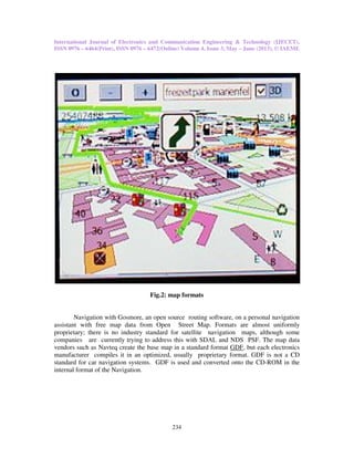
Fig. No.5: GIS users
Importance of GIS in Navigation System is that we can create maps and by using GCP’s
(ground control point) create rectified map.[1]
5. REMOTE SENSING
Taking a closer look from a distance is the concept behind remote sensing, broadly
defined as a method of obtaining information about properties of an object without coming
into physical contact with that object. [2]
A more specific definition of remote sensing relates to studying the environment from
a distance using techniques such as satellite imaging, aerial photography, and radar. While
the majority of remote sensing technologies utilize electromagnetic radiation for
measurements, other methods use seismic waves or acoustics. Sonar (sound navigation and
ranging) technology is used to collect measurements from the sea floor by collecting point or
raster data derived from the strength and time of the acoustic return. The National Oceanic
and Atmospheric Association (NOAA) uses single and multibeam sonar for numerous
applications like mapping seafloor geology, field verifying other remotely sensed data sets,
navigation, disaster recovery and salvage, and habitat studies, among other uses. [3]
The beginnings of remote sensing technology are based in photography. The first aerial
images of the earth were captured using cameras attached to balloons and kites in the mid-
nineteenth century. During World War I aerial views captured by cameras mounted on
airplanes were used for military reconnaissance. This method of aerial photography became
the standard for depicting the earth’s surface from a vertical (looking straight down) or
oblique (at various angles, generally less than 45°) perspective from that time until the 1960s.
[4]](https://image.slidesharecdn.com/navigationsystembyusinggisandgps-130712052326-phpapp01/85/Navigation-system-by-using-gis-and-gps-9-320.jpg)
![International Journal of Electronics and Communication Engineering & Technology (IJECET),
ISSN 0976 – 6464(Print), ISSN 0976 – 6472(Online) Volume 4, Issue 3, May – June (2013), © IAEME
241
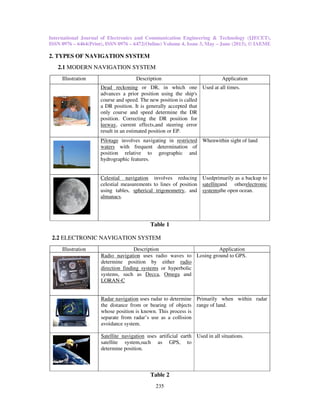
[5]
Fig No.6: Geometric Transformation](https://image.slidesharecdn.com/navigationsystembyusinggisandgps-130712052326-phpapp01/85/Navigation-system-by-using-gis-and-gps-10-320.jpg)
![International Journal of Electronics and Communication Engineering & Technology (IJECET),
ISSN 0976 – 6464(Print), ISSN 0976 – 6472(Online) Volume 4, Issue 3, May – June (2013), © IAEME
242
Satellites developed by Russian and American space programs expanded the field of
vision in the 1960s by obtaining views from beyond Earth’s atmosphere. Landstat, Nimbus, ERS,
RADARSAT and UARS are satellite programs used for earth observation. Images collected by
NASA’s Landsat satellite program, first launched in 1972, are used to monitor a number of
environmental factors including water quality, glacier recession, sea ice movement, invasive
species encroachment, coral reef health, land use change, deforestation rates and population
growth. Satellite imagery is also used to help assess damage from natural disasters such as fires,
floods, and tsunamis, and subsequently, plan disaster relief and flood control programs. [6]
Remote sensing methods are used to gain a better understanding of the Earth and its
functions. A Global Earth Observation System of Systems (GEOSS) is being developed to
connect earth observation systems around the world. A comprehensive and coordinated system of
earth observations could lead to better management of environmental data and could fulfill
numerous societal benefits including:
• Reducing loss of life and property from natural and human-induced disasters.
• Understanding environmental factors affecting human health and well-being.
• Improving management of energy resources.
• Understanding, assessing, predicting, mitigating, and adapting to climate variability and
change.
• Improving water resource management through better understanding of the water cycle.
• Improving weather information, forecasting and warning.
• Improving the management and protection of terrestrial, coastal and marine ecosystems.
• . Understanding, monitoring and conserving biodiversity. [7]
The Global Earth Observation System of Systems (GEOSS) 10-Year Implementation
Plan encourages the adoption of international standards to achieve interoperability among diverse
systems. IEEE Geoscience and Remote Sensing Society has identified the need to create
standards for standards for collecting, processing, storing, and disseminating shared metadata,
data, and derived products. [8]
6. CONCLUSION
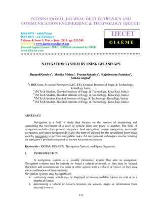
The technology of the Global Positioning System is allowing for huge changes in society.
The applications using GPS are constantly growing. The cost of the receivers is dropping while at
the same time the accuracy of the system is improving. This affects everyone with things such as
faster Internet speed and safer plane landings. Even though the system was originally developed
for military purposes, civil sales now exceed military sales (See Figure below).
Fig. 5 Graph of GPS
Remote sensing provides a cost-effective method for mapping and monitoring broad
areas, and has the advantage that the spread of diseases such as dieback is not enhanced by
remote monitoring. Archived data can be used to monitor how areas have changed through time.](https://image.slidesharecdn.com/navigationsystembyusinggisandgps-130712052326-phpapp01/85/Navigation-system-by-using-gis-and-gps-11-320.jpg)
![International Journal of Electronics and Communication Engineering & Technology (IJECET),
ISSN 0976 – 6464(Print), ISSN 0976 – 6472(Online) Volume 4, Issue 3, May – June (2013), © IAEME
243
REFERENCES
[1] Deepesh Namdev, S.Mangal, M.Singh,Image Processing with GIS and
ERDAS,Lambert Academic Publication, Germany,June- 2012.
[2] Bichlien Hoang American Meteorology Society “Glossary of Meteorology.”
[3] NOAA Coastal Services Center“Remote Sensing for Coastal Management.”
[4] NASA. “The Remote Sensing Tutorial.”
[5] James B.Campbell, Introduction to Remote Sensing, The Guilford Press Fourth
Edition, 2007
[6] NASA. “The Numbers Behind Landsat.”
[7] GEO-Group on Earth Observations “Societal Benefits”.
[8] Ashley Caudill IEEE Geoscience and Remote Sensing Society. “GEOSS Standards”.
[9] Seema vora, Prof.Mukesh Tiwari and Prof.Jaikaran Singh, “GSM Based Remote
Monitoring of Waste Gas at Locally Monitored GUI with the Implementation of
Modbus Protocol and Location Identification Through GPS”, International Journal of
Advanced Research in Engineering & Technology (IJARET), Volume 3, Issue 2, 2012,
pp. 52 - 59, ISSN Print: 0976-6480, ISSN Online: 0976-6499.
[10] Rahul T. Dahatonde and Shankar B. Deosarkar, “Design of Radiating-Edge Gap-
Coupled Broadband Microstrip Antenna for GPS Application”, International Journal of
Electronics and Communication Engineering & Technology (IJECET), Volume 3,
Issue 3, 2012, pp. 303 - 313, ISSN Print: 0976- 6464, ISSN Online: 0976 –6472.](https://image.slidesharecdn.com/navigationsystembyusinggisandgps-130712052326-phpapp01/85/Navigation-system-by-using-gis-and-gps-12-320.jpg)

The document describes a navigation system that uses GIS and GPS technologies. It discusses how GPS works by using timing signals from satellites to calculate a receiver's location. It explains that GPS requires at least 4 satellites to be visible to obtain an accurate position. It then provides details on the different segments that make up GPS, including 24-32 satellites in 6 orbital planes that together provide global coverage, ground control stations that track the satellites, and millions of user receivers. Finally, it gives examples of how GPS is used for vehicle navigation systems and electronic navigation systems on ships and aircraft.