SlideShare a Scribd company logo
Pratik K. Gaikwad et al Int. Journal of Engineering Research and Applications www.ijera.com
ISSN : 2248-9622, Vol. 4, Issue 5( Version 4), May 2014, pp. 28-33
www.ijera.com 28 | P a g e
Real-Time GPS Receiver System Implementation for Providing
Location Based Services and SMS Tracking
Pratik K. Gaikwad*, Sushant J. Pawar**
*(M.E, Department of Electronics and Telecommunication, Sandip Institute of Technology and Research
Centre, University of Pune, Nashik, India-422213)
** (Assistant professor, Department of Electronics and Telecommunication, Sandip Institute of Technology and
Research Centre, University of Pune, Nashik, India-422213)
ABSTRACT
This paper describes the design of a real-time GPS receiver system in a very simple and efficient fashion for
navigation, tracking and positioning. This system is designed to provide location based parameters in real time
like latitude, longitude, altitude, current location name and altitude. The values of these parameters are displayed
on a GUI (Graphical User Interface). The system also provides a website application where the values of the
parameters on the GUI are displayed in a tabulated form on the website. The parameter values are continuously
updated and are displayed on the GUI. The updated parameter values on the GUI are also added to the table in
the website. Hence the table shows the real-time parameter values along with the values which were previously
displayed on the GUI. An internet based SMS (Short Message Service) application is also developed which will
message the real time latitude, longitude, altitude, speed and location name to the user’s mobile. The system
consists of an antenna which acquires the satellite signals. These signals are given to the GPS receiver. The
receiver is provided with a Universal Serial Bus (USB) connector so that it compatible and can be easily
connected to a Personal Computer (PC) or laptop. The system software in the PC or laptop is developed in
Visual Basic.NET computer programming language. The system is easy to use and provides real-time results in
the form of visual displays.
Keywords - Global Positioning System, Graphical User Interface, Navigation, Positioning, Parameters.
I. Introduction
Navigation is defined as determination of
position and velocity of any still or moving entity on
land, sea, air or in the space [1]. In navigation the
position and its related parameters are required
immediately or after certain delay. This is called real
time navigation. Hence in order to navigate real time
data is required. In navigation the position is not
constant. It is variable and is dependent on time.
Before the advent of modern technologies there were
other methods of navigation like dead reckoning,
piloting, and celestial. These navigation systems were
dependant on geographic features, landmarks and
observation of positions of the sun, moon, planets
and navigational stars. Nowadays, navigation
primarily relies on positions determined
electronically by receivers collecting information
from satellites. Aircrafts, missiles, ships, sea vessels,
vehicles moving on land and even pedestrians use
modern satellite navigation systems. This satellite
navigation system is called as Global Positioning
System (GPS). GPS provides global coverage and
better accuracy as compared to other navigation
systems. GPS provides real time information of the
user’s location at any point on the surface of the earth
provided that user has a GPS receiver.
In this paper a real time GPS receiver system is
discussed. The system hardware consists of a GPS
antenna, GPS receiver with a USB connector so that
the receiver can be easily connected to a PC or
laptop. The system software is developed in VB.NET
computer programming language.
The GPS has been introduced in section 2.
Section 3 provides details of related works. The
system design has been discussed in section 4. The
system execution methodology has been described in
section 5. Section 6 explains the data format. Section
7 discusses the results obtained. Section 8 describes
the conclusion and section 9 the acknowledgement.
II. GPS overview
NAVSTAR (Navigation Satellite Timing and
Ranging) is a network of satellites that provides GPS
services all over the planet. The GPS is controlled and
maintained by the United States of America (U.S.A).
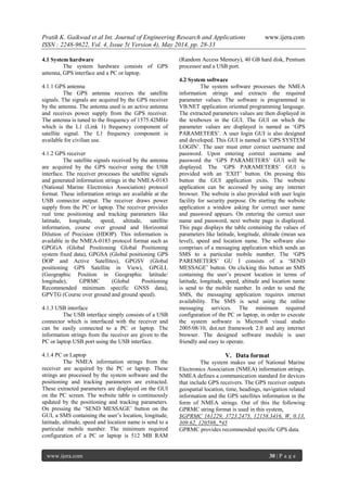
GPS consists of three segments. They are space
segment, control segment and user segment. The three
segments of the GPS shown in the fig. 1
RESEARCH ARTICLE OPEN ACCESS
Pratik K. Gaikwad et al Int. Journal of Engineering Research and Applications www.ijera.com
ISSN : 2248-9622, Vol. 4, Issue 5( Version 4), May 2014, pp. 28-33
www.ijera.com 29 | P a g e
Fig. 1 shows the segments of GPS
2.1 The space segment
The space segment consists of a core
constellation of 24 satellites. This constellation
ensures that the GPS receiver can track at least 4
satellites from any point on the planet. The satellites
fly in the MEO (Medium Earth Orbit) at an altitude of
about 20,200 km from the surface of the earth.
Presently the space segment consists of a 27 satellite
constellation. The extra three satellites ensure
increased coverage and improved accuracy of the GPS
system. The satellite signal received by the GPS
receiver consists of satellite orbital and clock
information, information and status regarding all the
satellites and an ionospheric model for error
correction.
2.2 Control segment
The GPS control segment consists of global
network of ground facilities that track the GPS
satellites, monitor and analyze their transmission and
send updated and corrected information to the
satellites. The control segment mainly consist of a
master control station, an alternate control station,
four dedicated ground antennas and six dedicated
control stations. The monitor stations track the
satellites, and constantly receive the satellite data.
This information is send to the master control station.
The master control station uses this information to
compute precise locations of the satellites in space
and uploads this information to the satellites using the
ground antennas.
2.3 User segment
The user segment is composed of numerous
military and civilian GPS receivers. The GPS receiver
may be held in hand or a can be mounted on the
vehicle. The user segment processes the satellite
signals and computes precise values of navigational
and positioning parameters like latitude, longitude,
altitude, speed, etc. The GPS receiver may include
display for providing location information to the user.
III. Related works
Over the past few years, many researchers
have designed and developed numerous applications
using GPS navigation system in the fields like
defense, transportation and space applications. Many
applications where GPS has been used with other
technologies like GSM, CDMA and internet to
provide mobile navigation and on-line tracking have
also been designed and developed. A complete GPS
receiver design and its implementation using simulink
graphical programming language is discussed in [2].
[3] Describes an advanced GPS signal processing
architecture and illustrates that how it can be applied
to extend the GPS coverage into difficult
environments such as indoors, urban canyon and
under dense urban canopies. A design of a software
based GPS/Galileo receiver, including a structure of
combined software GPS/Galileo receiver with
multipath mitigation and Receiver Autonomous
Integrity Monitoring (RAIM), which can utilize the
publicly available GPS and Galileo signals is
presented in [4]. A GPS-SBAS (Global Positioning
System-Satellite Based Augmentation System)
receiver which is developed using a Digital Signal
Processor (DSP) and engineered for use in avionics
applications is discussed in [5]. A discussion
regarding the use of ASIC, FPGA and DSP
technologies to design and develop future GNSS
(Global Navigation Satellite System) receivers is
given in [6]. A GPS receiver using a RF front end and
Analog to Digital converter, and a software approach
for acquisition, tracking and navigation is introduced
in [7].
IV. System design
The GPS receiver system block diagram is
shown in fig. 1. The system is composed of hardware
module and software module.
Fig. 2 shows GPS receiver system block diagram
The system hardware and system software
are described as follows,
Antenna
GPS receiver
USB Interface
Personal computer or Laptop
Pratik K. Gaikwad et al Int. Journal of Engineering Research and Applications www.ijera.com
ISSN : 2248-9622, Vol. 4, Issue 5( Version 4), May 2014, pp. 28-33
www.ijera.com 30 | P a g e
4.1 System hardware
The system hardware consists of GPS
antenna, GPS interface and a PC or laptop.
4.1.1 GPS antenna
The GPS antenna receives the satellite
signals. The signals are acquired by the GPS receiver
by the antenna. The antenna used is an active antenna
and receives power supply from the GPS receiver.
The antenna is tuned to the frequency of 1575.42MHz
which is the L1 (Link 1) frequency component of
satellite signal. The L1 frequency component is
available for civilian use.
4.1.2 GPS receiver
The satellite signals received by the antenna
are acquired by the GPS receiver using the USB
interface. The receiver processes the satellite signals
and generated information strings in the NMEA-0183
(National Marine Electronics Association) protocol
format. These information strings are available at the
USB connector output. The receiver draws power
supply from the PC or laptop. The receiver provides
real time positioning and tracking parameters like
latitude, longitude, speed, altitude, satellite
information, course over ground and Horizontal
Dilution of Precision (HDOP). This information is
available in the NMEA-0183 protocol format such as
GPGGA (Global Positioning Global Positioning
system fixed data), GPGSA (Global positioning GPS
DOP and Active Satellites), GPGSV (Global
positioning GPS Satellite in View), GPGLL
(Geographic Position in Geographic latitude/
longitude), GPRMC (Global Positioning
Recommended minimum specific GNSS data),
GPVTG (Course over ground and ground speed).
4.1.3 USB interface
The USB interface simply consists of a USB
connector which is interfaced with the receiver and
can be easily connected to a PC or laptop. The
information strings from the receiver are given to the
PC or laptop USB port using the USB interface.
4.1.4 PC or Laptop
The NMEA information strings from the
receiver are acquired by the PC or laptop. These
strings are processed by the system software and the
positioning and tracking parameters are extracted.
These extracted parameters are displayed on the GUI
on the PC screen. The website table is continuously
updated by the positioning and tracking parameters.
On pressing the ‘SEND MESSAGE’ button on the
GUI, a SMS containing the user’s location, longitude,
latitude, altitude, speed and location name is send to a
particular mobile number. The minimum required
configuration of a PC or laptop is 512 MB RAM
(Random Access Memory), 40 GB hard disk, Pentium
processor and a USB port.
4.2 System software
The system software processes the NMEA
information strings and extracts the required
parameter values. The software is programmed in
VB.NET application oriented programming language.
The extracted parameters values are then displayed in
the textboxes in the GUI. The GUI on which the
parameter values are displayed is named as ‘GPS
PARAMETERS’. A user login GUI is also designed
and developed. This GUI is named as ‘GPS SYSTEM
LOGIN’. The user must enter correct username and
password. Upon entering correct username and
password the ‘GPS PARAMETERS’ GUI will be
displayed. The ‘GPS PARAMETERS’ GUI is
provided with an ‘EXIT’ button. On pressing this
button the GUI application exits. The website
application can be accessed by using any internet
browser. The website is also provided with user login
facility for security purpose. On starting the website
application a window asking for correct user name
and password appears. On entering the correct user
name and password, next website page is displayed.
This page displays the table containing the values of
parameters like latitude, longitude, altitude (mean sea
level), speed and location name. The software also
comprises of a messaging application which sends an
SMS to a particular mobile number. The ‘GPS
PAREMETERS’ GU I consists of a ‘SEND
MESSAGE’ button. On clicking this button an SMS
containing the user’s present location in terms of
latitude, longitude, speed, altitude and location name
is send to the mobile number. In order to send the
SMS, the messaging application requires internet
availability. The SMS is send using the online
messaging services. The minimum required
configuration of the PC or laptop, in order to execute
the system software is Microsoft visual studio
2005/08/10, dot.net framework 2.0 and any internet
browser. The designed software module is user
friendly and easy to operate.
V. Data format
The system makes use of National Marine
Electronics Association (NMEA) information strings.
NMEA defines a communication standard for devices
that include GPS receivers. The GPS receiver outputs
geospatial location, time, headings, navigation related
information and the GPS satellites information in the
form of NMEA strings. Out of this the following
GPRMC string format is used in this system,
$GPRMC 161229, 3723.2475, 12158.3416, W, 0.13,
309.62, 120598,,*45
GPRMC provides recommended specific GPS data.
Pratik K. Gaikwad et al Int. Journal of Engineering Research and Applications www.ijera.com
ISSN : 2248-9622, Vol. 4, Issue 5( Version 4), May 2014, pp. 28-33
www.ijera.com 31 | P a g e
VI. System execution methodology
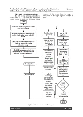
The GPS receiver system execution flow is
shown in the fig. 3. The flow chart presents the
system working in detail. All the stages and the
processes of the system from the stage of
initialization till the output stage are described in
detail.
Fig. 3 shows the system execution flow sequence
Pratik K. Gaikwad et al Int. Journal of Engineering Research and Applications www.ijera.com
ISSN : 2248-9622, Vol. 4, Issue 5( Version 4), May 2014, pp. 28-33
www.ijera.com 32 | P a g e
VII. Results
To evaluate the performance of the system
the results of the system were noted. The results of
the system are tabulated and are presented in table 1
and table 2.
Table 1 shows the location based parameters of the
GPS receiver system user like Latitude, Longitude
and Altitude at certain locations
Sr.
no.
Latitude (N) Longitude
(S)
Altitude
(m)
1 2001.9827 07378.7393 620.5
2 2001.8876 07378.7396 620.8
3 2001.6145 07378.4064 621.4
4 2001.1254 07377.5020 622.8
5 2000.8902 07377.2241 621.3
6 2000.7145 07377.1345 622.7
7 2000.5021 07377.0624 623.1
8 1999.8155 07376.9186 623.0
9 1999.7990 07376.9192 622.4
10 1999.4638 07376.9234 621.8
11 1999.4324 07376.3094 620.7
12 1999.3750 07375.4035 620.4
13 1999.1245 07375.0268 620.7
14 1998.9842 07375.6424 620.7
15 1998.2476 07375.9534 620.3
The results in the table 1 are obtained from
‘GPS PARAMETERS’ GUI. The parameters like
Latitude, longitude and Altitude of certain locations
are tabulated and are shown in the table 1. Using the
latitude and longitude values the location of the user
at any point on the planet can be found. The altitude
value is the altitude of the user above mean sea level.
The parameter values in the table 1 are also displayed
in the website in tabulated form.
Table 2 shows the speed and location names of the
user for the same locations as in table 1
Sr. no. Speed
(km/hr)
Actual Point/Location
name
1 5.42 A
2 5.26 B
3 5.34 C
4 6.5 D
5 6.43 E
6 7.57 F
7 8.12 G
8 8.46 H
9 7.58 I
10 6.42 J
11 6.54 K
12 7.58 L
13 3.25 M
14 4.26 N
15 6.44 O
The results in the table 2 are also displayed
in ‘GPS PARAMETERS’ GUI. The speed and the
location names of the user’s position are for same
locations for which the values of the location based
parameters are given in table 1. The speed and the
location names are also displayed in the website table
along with the other parameters. For brevity the
location names are written in symbolic form.
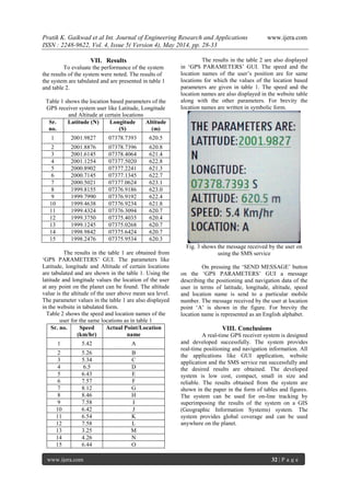
Fig. 3 shows the message received by the user on
using the SMS service
On pressing the ‘SEND MESSAGE’ button
on the ‘GPS PARAMETERS’ GUI a message
describing the positioning and navigation data of the
user in terms of latitude, longitude, altitude, speed
and location name is send to a particular mobile
number. The message received by the user at location
point ‘A’ is shown in the figure. For brevity the
location name is represented as an English alphabet.
VIII. Conclusions
A real-time GPS receiver system is designed
and developed successfully. The system provides
real-time positioning and navigation information. All
the applications like GUI application, website
application and the SMS service run successfully and
the desired results are obtained. The developed
system is low cost, compact, small in size and
reliable. The results obtained from the system are
shown in the paper in the form of tables and figures.
The system can be used for on-line tracking by
superimposing the results of the system on a GIS
(Geographic Information Systems) system. The
system provides global coverage and can be used
anywhere on the planet.
Pratik K. Gaikwad et al Int. Journal of Engineering Research and Applications www.ijera.com
ISSN : 2248-9622, Vol. 4, Issue 5( Version 4), May 2014, pp. 28-33
www.ijera.com 33 | P a g e
IX. Acknowledgement
I offer my sincere thanks to all who have
supported me and have given valuable suggestions
during the completion of this paper. I am thankful to
my guide Mr. Sushant J. Pawar for guiding me and
giving helpful insights during the completion of this
paper.
REFERENCES
[1] M. Kayton, Navigation Systems, in G. R.
Spitzer (Ed.), The Avionics Handbook,
(Boca-Raton: CRC Press, 2000), 13-1-13-
10.
[2] G. Hamza, A, Zekry, I. Motawie,
Implementation of a Complete GPS
Receiver Using Simulink, IEEE Circuits and
Systems Magazine, 9(4), 2011, 43-51.
[3] A. soloview, J. Dickman, N. Grumman,
Extending GPS Carrier Availability Indoors
with a Deeply Integrated Receiver
Architecture, IEEE Wireless
Communications, 18(2), 2011, 36-44.
[4] L. Xiaoli, L. Jingnan, L. Tao, H. Xi, Design
of Software Galileo Receiver for
Applications, Management and Technology
Forum ,China Communication, 4(6) 2006,
42-49.
[5] J. K. Ray, R. A. Nayak, S. Muralikrishna, S.
Kiran, K. R. Shashidhara, M. R. Shenoy,
HIGH integrity GPS-SBAS Receiver Using
Innovative Correlator and Software
Approach for Avionics Applications, Proc.
17th
International Technical Meeting of the
Satellite Division of The Institute of
Navigation, Long Beach, California, 2004,
1539-1545.
[6] G. W. Hein, T. Pany, S. Wallner, J. Won,
Platforms for a Future GNSS Receiver A
Discussion of ASIC, FPGA, and DSP
Technologies, InsideGNSS, 1(2), 2006, 56-
62.
[7] J. B. Tsui, Fundamentals of Global
Positioning System Receivers A Software
Approach (Hoboken, NJ: John Wiley and
Sons, 2000).

More Related Content

What's hot

Remote sensing satellite data demodulation and bit synchronization 2
Remote sensing satellite data demodulation and bit synchronization 2Remote sensing satellite data demodulation and bit synchronization 2
Remote sensing satellite data demodulation and bit synchronization 2IAEME Publication
 
DESIGN OF INTELLIGENT MOBILE VEHICLE CHECKING SYSTEM BASED ON ARM 7
DESIGN OF INTELLIGENT MOBILE VEHICLE CHECKING SYSTEM BASED ON ARM 7DESIGN OF INTELLIGENT MOBILE VEHICLE CHECKING SYSTEM BASED ON ARM 7
DESIGN OF INTELLIGENT MOBILE VEHICLE CHECKING SYSTEM BASED ON ARM 7
Noor Mohammad's Faltoos
 
Gps tracking system
Gps tracking system Gps tracking system
Gps tracking system Sumit Kumar
 
GPS Instrumental Biases Estimation Using Continuous Operating Receivers Network
GPS Instrumental Biases Estimation Using Continuous Operating Receivers NetworkGPS Instrumental Biases Estimation Using Continuous Operating Receivers Network
GPS Instrumental Biases Estimation Using Continuous Operating Receivers Network
CSCJournals
 
Mobileworxs Ec Mobile Gps Applications White Paper[1]
Mobileworxs Ec Mobile Gps Applications White Paper[1]Mobileworxs Ec Mobile Gps Applications White Paper[1]
Mobileworxs Ec Mobile Gps Applications White Paper[1]MobileWorxs
 
Terrestrial gps positioning system
Terrestrial gps positioning systemTerrestrial gps positioning system
Terrestrial gps positioning system
eSAT Publishing House
 
Assessment of the Accuracy of Processing GPS Static Baselines Up To 40 Km Us...
Assessment of the Accuracy of Processing GPS Static Baselines  Up To 40 Km Us...Assessment of the Accuracy of Processing GPS Static Baselines  Up To 40 Km Us...
Assessment of the Accuracy of Processing GPS Static Baselines Up To 40 Km Us...
IJMER
 
Time from the Sky
Time from the SkyTime from the Sky
Time from the Sky
3G4G
 
Gsm based advance security and rtealtime vehicle tracking using gps technolgy 3
Gsm based advance security and rtealtime vehicle tracking using gps technolgy 3Gsm based advance security and rtealtime vehicle tracking using gps technolgy 3
Gsm based advance security and rtealtime vehicle tracking using gps technolgy 3
Hardik Patel
 
GPS based tracking system
GPS based tracking systemGPS based tracking system
GPS based tracking system
UVSofts Technologies
 
Positioning in Location Based Services
Positioning in Location Based ServicesPositioning in Location Based Services
Positioning in Location Based Services
essi
 
REAL-TIME VEHICLE LOCKING AND TRACKING SYSTEM USING GSM AND GPS TECHNOLOGY-A...
REAL-TIME VEHICLE  LOCKING AND TRACKING SYSTEM USING GSM AND GPS TECHNOLOGY-A...REAL-TIME VEHICLE  LOCKING AND TRACKING SYSTEM USING GSM AND GPS TECHNOLOGY-A...
REAL-TIME VEHICLE LOCKING AND TRACKING SYSTEM USING GSM AND GPS TECHNOLOGY-A...Sandeep Kunsoth
 
Sensor Platform and UAV for multiple, simultaneous measurements in Precision ...
Sensor Platform and UAV for multiple, simultaneous measurements in Precision ...Sensor Platform and UAV for multiple, simultaneous measurements in Precision ...
Sensor Platform and UAV for multiple, simultaneous measurements in Precision ...
CAPIGI
 
Time distribution strategies in cellular networks
Time distribution strategies in cellular networksTime distribution strategies in cellular networks
Time distribution strategies in cellular networks
Nir Cohen
 
ACCIDENT DETECTION AND VEHICLE TRACKING USING GPS,GSM AND MEMS
ACCIDENT DETECTION AND VEHICLE TRACKING USING GPS,GSM AND MEMSACCIDENT DETECTION AND VEHICLE TRACKING USING GPS,GSM AND MEMS
ACCIDENT DETECTION AND VEHICLE TRACKING USING GPS,GSM AND MEMS
Krishna Moparthi
 
International Journal of Computational Engineering Research (IJCER)
International Journal of Computational Engineering Research (IJCER)International Journal of Computational Engineering Research (IJCER)
International Journal of Computational Engineering Research (IJCER)
ijceronline
 
GNSS interference reduction method for CORS site planning
GNSS interference reduction method for CORS site planningGNSS interference reduction method for CORS site planning
GNSS interference reduction method for CORS site planning
TELKOMNIKA JOURNAL
 
Indoor positioning based on enhanced utdoa (R1-150419)
Indoor positioning based on enhanced utdoa (R1-150419)Indoor positioning based on enhanced utdoa (R1-150419)
Indoor positioning based on enhanced utdoa (R1-150419)
Yi-Hsueh Tsai
 
Nanotechnology based satellite communication system
Nanotechnology based satellite communication systemNanotechnology based satellite communication system
Nanotechnology based satellite communication system
Sarah Christy
 

What's hot (20)

Remote sensing satellite data demodulation and bit synchronization 2
Remote sensing satellite data demodulation and bit synchronization 2Remote sensing satellite data demodulation and bit synchronization 2
Remote sensing satellite data demodulation and bit synchronization 2
 
DESIGN OF INTELLIGENT MOBILE VEHICLE CHECKING SYSTEM BASED ON ARM 7
DESIGN OF INTELLIGENT MOBILE VEHICLE CHECKING SYSTEM BASED ON ARM 7DESIGN OF INTELLIGENT MOBILE VEHICLE CHECKING SYSTEM BASED ON ARM 7
DESIGN OF INTELLIGENT MOBILE VEHICLE CHECKING SYSTEM BASED ON ARM 7
 
Gps tracking system
Gps tracking system Gps tracking system
Gps tracking system
 
GPS Instrumental Biases Estimation Using Continuous Operating Receivers Network
GPS Instrumental Biases Estimation Using Continuous Operating Receivers NetworkGPS Instrumental Biases Estimation Using Continuous Operating Receivers Network
GPS Instrumental Biases Estimation Using Continuous Operating Receivers Network
 
Mobileworxs Ec Mobile Gps Applications White Paper[1]
Mobileworxs Ec Mobile Gps Applications White Paper[1]Mobileworxs Ec Mobile Gps Applications White Paper[1]
Mobileworxs Ec Mobile Gps Applications White Paper[1]
 
Terrestrial gps positioning system
Terrestrial gps positioning systemTerrestrial gps positioning system
Terrestrial gps positioning system
 
Assessment of the Accuracy of Processing GPS Static Baselines Up To 40 Km Us...
Assessment of the Accuracy of Processing GPS Static Baselines  Up To 40 Km Us...Assessment of the Accuracy of Processing GPS Static Baselines  Up To 40 Km Us...
Assessment of the Accuracy of Processing GPS Static Baselines Up To 40 Km Us...
 
Time from the Sky
Time from the SkyTime from the Sky
Time from the Sky
 
Gsm based advance security and rtealtime vehicle tracking using gps technolgy 3
Gsm based advance security and rtealtime vehicle tracking using gps technolgy 3Gsm based advance security and rtealtime vehicle tracking using gps technolgy 3
Gsm based advance security and rtealtime vehicle tracking using gps technolgy 3
 
GPS based tracking system
GPS based tracking systemGPS based tracking system
GPS based tracking system
 
Positioning in Location Based Services
Positioning in Location Based ServicesPositioning in Location Based Services
Positioning in Location Based Services
 
REAL-TIME VEHICLE LOCKING AND TRACKING SYSTEM USING GSM AND GPS TECHNOLOGY-A...
REAL-TIME VEHICLE  LOCKING AND TRACKING SYSTEM USING GSM AND GPS TECHNOLOGY-A...REAL-TIME VEHICLE  LOCKING AND TRACKING SYSTEM USING GSM AND GPS TECHNOLOGY-A...
REAL-TIME VEHICLE LOCKING AND TRACKING SYSTEM USING GSM AND GPS TECHNOLOGY-A...
 
Sensor Platform and UAV for multiple, simultaneous measurements in Precision ...
Sensor Platform and UAV for multiple, simultaneous measurements in Precision ...Sensor Platform and UAV for multiple, simultaneous measurements in Precision ...
Sensor Platform and UAV for multiple, simultaneous measurements in Precision ...
 
Time distribution strategies in cellular networks
Time distribution strategies in cellular networksTime distribution strategies in cellular networks
Time distribution strategies in cellular networks
 
ACCIDENT DETECTION AND VEHICLE TRACKING USING GPS,GSM AND MEMS
ACCIDENT DETECTION AND VEHICLE TRACKING USING GPS,GSM AND MEMSACCIDENT DETECTION AND VEHICLE TRACKING USING GPS,GSM AND MEMS
ACCIDENT DETECTION AND VEHICLE TRACKING USING GPS,GSM AND MEMS
 
International Journal of Computational Engineering Research (IJCER)
International Journal of Computational Engineering Research (IJCER)International Journal of Computational Engineering Research (IJCER)
International Journal of Computational Engineering Research (IJCER)
 
GNSS interference reduction method for CORS site planning
GNSS interference reduction method for CORS site planningGNSS interference reduction method for CORS site planning
GNSS interference reduction method for CORS site planning
 
Indoor positioning based on enhanced utdoa (R1-150419)
Indoor positioning based on enhanced utdoa (R1-150419)Indoor positioning based on enhanced utdoa (R1-150419)
Indoor positioning based on enhanced utdoa (R1-150419)
 
Smart grid and wide area monitoring
Smart grid and wide area monitoringSmart grid and wide area monitoring
Smart grid and wide area monitoring
 
Nanotechnology based satellite communication system
Nanotechnology based satellite communication systemNanotechnology based satellite communication system
Nanotechnology based satellite communication system
 

Viewers also liked

Presentación proyecto multimedia
Presentación proyecto multimediaPresentación proyecto multimedia
Presentación proyecto multimediaLina Guarin
 
Death Note 04
Death Note 04Death Note 04
Death Note 04
Animalog ANimes Online
 
10 Death Note 10
10 Death Note 1010 Death Note 10
10 Death Note 10
Animalog ANimes Online
 
Democracia em Crise? - Nicholas Merlone
Democracia em Crise? - Nicholas MerloneDemocracia em Crise? - Nicholas Merlone
Democracia em Crise? - Nicholas Merlone
Nicholas Merlone
 
Aprendizaje de Adultos
Aprendizaje de  AdultosAprendizaje de  Adultos
Aprendizaje de Adultos
Teda Lecaros
 
Animalog Death Note 01
Animalog Death Note 01Animalog Death Note 01
Animalog Death Note 01
Animalog ANimes Online
 
Asset Pricing at the millennium
Asset Pricing at the millenniumAsset Pricing at the millennium
Asset Pricing at the millenniumAhmedSaba
 
Campus Virtual
Campus VirtualCampus Virtual
Campus Virtual
las5cumbres
 
Los Viajes De Luis Y Yolanda
Los Viajes De Luis Y YolandaLos Viajes De Luis Y Yolanda
Los Viajes De Luis Y Yolanda
guest9439cc
 
Mãe que Faz História
Mãe que Faz HistóriaMãe que Faz História
Mãe que Faz História
4UComunicacao
 
Trabajo De Educacion Fisica
Trabajo De Educacion FisicaTrabajo De Educacion Fisica
Trabajo De Educacion Fisicaguest65c993
 
Squadre 2013 2014
Squadre 2013 2014Squadre 2013 2014
Squadre 2013 2014
Volare Volley
 
Portafolioelectrnico4697926004 1207616238353934-8[1]
Portafolioelectrnico4697926004 1207616238353934-8[1]Portafolioelectrnico4697926004 1207616238353934-8[1]
Portafolioelectrnico4697926004 1207616238353934-8[1]Avila Claudia
 
心開路就開
心開路就開心開路就開
心開路就開Jaing Lai
 
羅浮宫的30座雕塑
羅浮宫的30座雕塑羅浮宫的30座雕塑
羅浮宫的30座雕塑Jaing Lai
 
誰偷走了我的健康
誰偷走了我的健康誰偷走了我的健康
誰偷走了我的健康Jaing Lai
 
D045062629
D045062629D045062629
D045062629
IJERA Editor
 
EducacióN Socio Ambiental1
EducacióN Socio Ambiental1EducacióN Socio Ambiental1
EducacióN Socio Ambiental1guest88d57e
 
Info.nl @ Social Media Congres 18 feb 2010
Info.nl @ Social Media Congres 18 feb 2010Info.nl @ Social Media Congres 18 feb 2010
Info.nl @ Social Media Congres 18 feb 2010
Info.nl
 

Viewers also liked (20)

Presentación proyecto multimedia
Presentación proyecto multimediaPresentación proyecto multimedia
Presentación proyecto multimedia
 
Death Note 04
Death Note 04Death Note 04
Death Note 04
 
10 Death Note 10
10 Death Note 1010 Death Note 10
10 Death Note 10
 
America precolombina
America precolombinaAmerica precolombina
America precolombina
 
Democracia em Crise? - Nicholas Merlone
Democracia em Crise? - Nicholas MerloneDemocracia em Crise? - Nicholas Merlone
Democracia em Crise? - Nicholas Merlone
 
Aprendizaje de Adultos
Aprendizaje de  AdultosAprendizaje de  Adultos
Aprendizaje de Adultos
 
Animalog Death Note 01
Animalog Death Note 01Animalog Death Note 01
Animalog Death Note 01
 
Asset Pricing at the millennium
Asset Pricing at the millenniumAsset Pricing at the millennium
Asset Pricing at the millennium
 
Campus Virtual
Campus VirtualCampus Virtual
Campus Virtual
 
Los Viajes De Luis Y Yolanda
Los Viajes De Luis Y YolandaLos Viajes De Luis Y Yolanda
Los Viajes De Luis Y Yolanda
 
Mãe que Faz História
Mãe que Faz HistóriaMãe que Faz História
Mãe que Faz História
 
Trabajo De Educacion Fisica
Trabajo De Educacion FisicaTrabajo De Educacion Fisica
Trabajo De Educacion Fisica
 
Squadre 2013 2014
Squadre 2013 2014Squadre 2013 2014
Squadre 2013 2014
 
Portafolioelectrnico4697926004 1207616238353934-8[1]
Portafolioelectrnico4697926004 1207616238353934-8[1]Portafolioelectrnico4697926004 1207616238353934-8[1]
Portafolioelectrnico4697926004 1207616238353934-8[1]
 
心開路就開
心開路就開心開路就開
心開路就開
 
羅浮宫的30座雕塑
羅浮宫的30座雕塑羅浮宫的30座雕塑
羅浮宫的30座雕塑
 
誰偷走了我的健康
誰偷走了我的健康誰偷走了我的健康
誰偷走了我的健康
 
D045062629
D045062629D045062629
D045062629
 
EducacióN Socio Ambiental1
EducacióN Socio Ambiental1EducacióN Socio Ambiental1
EducacióN Socio Ambiental1
 
Info.nl @ Social Media Congres 18 feb 2010
Info.nl @ Social Media Congres 18 feb 2010Info.nl @ Social Media Congres 18 feb 2010
Info.nl @ Social Media Congres 18 feb 2010
 

Similar to E045032833

GPS Receiver ICS2014
GPS Receiver ICS2014GPS Receiver ICS2014
GPS Receiver ICS2014Mazhar Abbas
 
REAL TIME WEB BASED SYSTEM FOR OBSERVING SAG AT SUBSTATION
REAL TIME WEB BASED SYSTEM FOR OBSERVING SAG AT SUBSTATIONREAL TIME WEB BASED SYSTEM FOR OBSERVING SAG AT SUBSTATION
REAL TIME WEB BASED SYSTEM FOR OBSERVING SAG AT SUBSTATION
IJCSEA Journal
 
A remote-controlled global navigation satellite system based rover for accur...
A remote-controlled global navigation satellite system based  rover for accur...A remote-controlled global navigation satellite system based  rover for accur...
A remote-controlled global navigation satellite system based rover for accur...
IJECEIAES
 
Advanced Anti Accidental Solution by Pre Analyzing, Tracking and Detection of...
Advanced Anti Accidental Solution by Pre Analyzing, Tracking and Detection of...Advanced Anti Accidental Solution by Pre Analyzing, Tracking and Detection of...
Advanced Anti Accidental Solution by Pre Analyzing, Tracking and Detection of...
IRJET Journal
 
Global positioning system(GPS)
Global positioning system(GPS)Global positioning system(GPS)
Global positioning system(GPS)
shifa
 
Iaetsd location-based services using autonomous gps
Iaetsd location-based services using autonomous gpsIaetsd location-based services using autonomous gps
Iaetsd location-based services using autonomous gps
Iaetsd Iaetsd
 
Design of field programmable gate array-based data processing system for mul...
Design of field programmable gate array-based data processing  system for mul...Design of field programmable gate array-based data processing  system for mul...
Design of field programmable gate array-based data processing system for mul...
IJECEIAES
 
Different GNSS (Global Navigation Satellite System) Receiver’s combination an...
Different GNSS (Global Navigation Satellite System) Receiver’s combination an...Different GNSS (Global Navigation Satellite System) Receiver’s combination an...
Different GNSS (Global Navigation Satellite System) Receiver’s combination an...
IJMTST Journal
 
Localization using filtered dgps
Localization using filtered dgpsLocalization using filtered dgps
Localization using filtered dgps
eSAT Journals
 
Location in ubiquitous computing, LOCATION SYSTEMS
Location in ubiquitous computing, LOCATION SYSTEMSLocation in ubiquitous computing, LOCATION SYSTEMS
Location in ubiquitous computing, LOCATION SYSTEMS
Salah Amean
 
GPS Based Vehicle Location using ARM 7 LPC 2148
GPS Based Vehicle Location using ARM 7 LPC 2148GPS Based Vehicle Location using ARM 7 LPC 2148
GPS Based Vehicle Location using ARM 7 LPC 2148
IRJET Journal
 
Vehicle Tracking System for School Bus by Arduino
Vehicle Tracking System for School Bus by ArduinoVehicle Tracking System for School Bus by Arduino
Vehicle Tracking System for School Bus by Arduino
IRJET Journal
 
A comprehensive insight towards pre-processing methodologies applied on GPS d...
A comprehensive insight towards pre-processing methodologies applied on GPS d...A comprehensive insight towards pre-processing methodologies applied on GPS d...
A comprehensive insight towards pre-processing methodologies applied on GPS d...
IJECEIAES
 
GAGAN (GPS Aided Geo Augmented Navigation)
GAGAN (GPS Aided Geo Augmented Navigation)GAGAN (GPS Aided Geo Augmented Navigation)
GAGAN (GPS Aided Geo Augmented Navigation)
Prakhar Aditya
 
GPS Tracking System.pptx
GPS Tracking System.pptxGPS Tracking System.pptx
GPS Tracking System.pptx
RakeshGupta831
 
Vehicle Tracking System by Arduino UNO
Vehicle Tracking System by Arduino UNOVehicle Tracking System by Arduino UNO
Vehicle Tracking System by Arduino UNO
Pulkit Singhal
 
Latest Advances in GPS technology Seminar report
Latest Advances in GPS technology Seminar reportLatest Advances in GPS technology Seminar report
Latest Advances in GPS technology Seminar report
Mode Gautam Raj
 
Automatic Vehicle Locator(AVL) Seminar report
 Automatic Vehicle Locator(AVL) Seminar report Automatic Vehicle Locator(AVL) Seminar report
Automatic Vehicle Locator(AVL) Seminar report
Rohit Kumar patel
 
GLONASS and GSM based Vehicle Tracking System
GLONASS and GSM based Vehicle Tracking SystemGLONASS and GSM based Vehicle Tracking System
GLONASS and GSM based Vehicle Tracking System
IRJET Journal
 

Similar to E045032833 (20)

GPS Receiver ICS2014
GPS Receiver ICS2014GPS Receiver ICS2014
GPS Receiver ICS2014
 
REAL TIME WEB BASED SYSTEM FOR OBSERVING SAG AT SUBSTATION
REAL TIME WEB BASED SYSTEM FOR OBSERVING SAG AT SUBSTATIONREAL TIME WEB BASED SYSTEM FOR OBSERVING SAG AT SUBSTATION
REAL TIME WEB BASED SYSTEM FOR OBSERVING SAG AT SUBSTATION
 
A remote-controlled global navigation satellite system based rover for accur...
A remote-controlled global navigation satellite system based  rover for accur...A remote-controlled global navigation satellite system based  rover for accur...
A remote-controlled global navigation satellite system based rover for accur...
 
Advanced Anti Accidental Solution by Pre Analyzing, Tracking and Detection of...
Advanced Anti Accidental Solution by Pre Analyzing, Tracking and Detection of...Advanced Anti Accidental Solution by Pre Analyzing, Tracking and Detection of...
Advanced Anti Accidental Solution by Pre Analyzing, Tracking and Detection of...
 
Global positioning system(GPS)
Global positioning system(GPS)Global positioning system(GPS)
Global positioning system(GPS)
 
Iaetsd location-based services using autonomous gps
Iaetsd location-based services using autonomous gpsIaetsd location-based services using autonomous gps
Iaetsd location-based services using autonomous gps
 
Design of field programmable gate array-based data processing system for mul...
Design of field programmable gate array-based data processing  system for mul...Design of field programmable gate array-based data processing  system for mul...
Design of field programmable gate array-based data processing system for mul...
 
Different GNSS (Global Navigation Satellite System) Receiver’s combination an...
Different GNSS (Global Navigation Satellite System) Receiver’s combination an...Different GNSS (Global Navigation Satellite System) Receiver’s combination an...
Different GNSS (Global Navigation Satellite System) Receiver’s combination an...
 
GPS
GPS GPS
GPS
 
Localization using filtered dgps
Localization using filtered dgpsLocalization using filtered dgps
Localization using filtered dgps
 
Location in ubiquitous computing, LOCATION SYSTEMS
Location in ubiquitous computing, LOCATION SYSTEMSLocation in ubiquitous computing, LOCATION SYSTEMS
Location in ubiquitous computing, LOCATION SYSTEMS
 
GPS Based Vehicle Location using ARM 7 LPC 2148
GPS Based Vehicle Location using ARM 7 LPC 2148GPS Based Vehicle Location using ARM 7 LPC 2148
GPS Based Vehicle Location using ARM 7 LPC 2148
 
Vehicle Tracking System for School Bus by Arduino
Vehicle Tracking System for School Bus by ArduinoVehicle Tracking System for School Bus by Arduino
Vehicle Tracking System for School Bus by Arduino
 
A comprehensive insight towards pre-processing methodologies applied on GPS d...
A comprehensive insight towards pre-processing methodologies applied on GPS d...A comprehensive insight towards pre-processing methodologies applied on GPS d...
A comprehensive insight towards pre-processing methodologies applied on GPS d...
 
GAGAN (GPS Aided Geo Augmented Navigation)
GAGAN (GPS Aided Geo Augmented Navigation)GAGAN (GPS Aided Geo Augmented Navigation)
GAGAN (GPS Aided Geo Augmented Navigation)
 
GPS Tracking System.pptx
GPS Tracking System.pptxGPS Tracking System.pptx
GPS Tracking System.pptx
 
Vehicle Tracking System by Arduino UNO
Vehicle Tracking System by Arduino UNOVehicle Tracking System by Arduino UNO
Vehicle Tracking System by Arduino UNO
 
Latest Advances in GPS technology Seminar report
Latest Advances in GPS technology Seminar reportLatest Advances in GPS technology Seminar report
Latest Advances in GPS technology Seminar report
 
Automatic Vehicle Locator(AVL) Seminar report
 Automatic Vehicle Locator(AVL) Seminar report Automatic Vehicle Locator(AVL) Seminar report
Automatic Vehicle Locator(AVL) Seminar report
 
GLONASS and GSM based Vehicle Tracking System
GLONASS and GSM based Vehicle Tracking SystemGLONASS and GSM based Vehicle Tracking System
GLONASS and GSM based Vehicle Tracking System
 

Recently uploaded

GenAISummit 2024 May 28 Sri Ambati Keynote: AGI Belongs to The Community in O...
GenAISummit 2024 May 28 Sri Ambati Keynote: AGI Belongs to The Community in O...GenAISummit 2024 May 28 Sri Ambati Keynote: AGI Belongs to The Community in O...
GenAISummit 2024 May 28 Sri Ambati Keynote: AGI Belongs to The Community in O...
Sri Ambati
 
Mission to Decommission: Importance of Decommissioning Products to Increase E...
Mission to Decommission: Importance of Decommissioning Products to Increase E...Mission to Decommission: Importance of Decommissioning Products to Increase E...
Mission to Decommission: Importance of Decommissioning Products to Increase E...
Product School
 
Builder.ai Founder Sachin Dev Duggal's Strategic Approach to Create an Innova...
Builder.ai Founder Sachin Dev Duggal's Strategic Approach to Create an Innova...Builder.ai Founder Sachin Dev Duggal's Strategic Approach to Create an Innova...
Builder.ai Founder Sachin Dev Duggal's Strategic Approach to Create an Innova...
Ramesh Iyer
 
Essentials of Automations: Optimizing FME Workflows with Parameters
Essentials of Automations: Optimizing FME Workflows with ParametersEssentials of Automations: Optimizing FME Workflows with Parameters
Essentials of Automations: Optimizing FME Workflows with Parameters
Safe Software
 
The Future of Platform Engineering
The Future of Platform EngineeringThe Future of Platform Engineering
The Future of Platform Engineering
Jemma Hussein Allen
 
How world-class product teams are winning in the AI era by CEO and Founder, P...
How world-class product teams are winning in the AI era by CEO and Founder, P...How world-class product teams are winning in the AI era by CEO and Founder, P...
How world-class product teams are winning in the AI era by CEO and Founder, P...
Product School
 
FIDO Alliance Osaka Seminar: FIDO Security Aspects.pdf
FIDO Alliance Osaka Seminar: FIDO Security Aspects.pdfFIDO Alliance Osaka Seminar: FIDO Security Aspects.pdf
FIDO Alliance Osaka Seminar: FIDO Security Aspects.pdf
FIDO Alliance
 
Smart TV Buyer Insights Survey 2024 by 91mobiles.pdf
Smart TV Buyer Insights Survey 2024 by 91mobiles.pdfSmart TV Buyer Insights Survey 2024 by 91mobiles.pdf
Smart TV Buyer Insights Survey 2024 by 91mobiles.pdf
91mobiles
 
GraphRAG is All You need? LLM & Knowledge Graph
GraphRAG is All You need? LLM & Knowledge GraphGraphRAG is All You need? LLM & Knowledge Graph
GraphRAG is All You need? LLM & Knowledge Graph
Guy Korland
 
Software Delivery At the Speed of AI: Inflectra Invests In AI-Powered Quality
Software Delivery At the Speed of AI: Inflectra Invests In AI-Powered QualitySoftware Delivery At the Speed of AI: Inflectra Invests In AI-Powered Quality
Software Delivery At the Speed of AI: Inflectra Invests In AI-Powered Quality
Inflectra
 
Designing Great Products: The Power of Design and Leadership by Chief Designe...
Designing Great Products: The Power of Design and Leadership by Chief Designe...Designing Great Products: The Power of Design and Leadership by Chief Designe...
Designing Great Products: The Power of Design and Leadership by Chief Designe...
Product School
 
Slack (or Teams) Automation for Bonterra Impact Management (fka Social Soluti...
Slack (or Teams) Automation for Bonterra Impact Management (fka Social Soluti...Slack (or Teams) Automation for Bonterra Impact Management (fka Social Soluti...
Slack (or Teams) Automation for Bonterra Impact Management (fka Social Soluti...
Jeffrey Haguewood
 
ODC, Data Fabric and Architecture User Group
ODC, Data Fabric and Architecture User GroupODC, Data Fabric and Architecture User Group
ODC, Data Fabric and Architecture User Group
CatarinaPereira64715
 
DevOps and Testing slides at DASA Connect
DevOps and Testing slides at DASA ConnectDevOps and Testing slides at DASA Connect
DevOps and Testing slides at DASA Connect
Kari Kakkonen
 
FIDO Alliance Osaka Seminar: Passkeys and the Road Ahead.pdf
FIDO Alliance Osaka Seminar: Passkeys and the Road Ahead.pdfFIDO Alliance Osaka Seminar: Passkeys and the Road Ahead.pdf
FIDO Alliance Osaka Seminar: Passkeys and the Road Ahead.pdf
FIDO Alliance
 
From Daily Decisions to Bottom Line: Connecting Product Work to Revenue by VP...
From Daily Decisions to Bottom Line: Connecting Product Work to Revenue by VP...From Daily Decisions to Bottom Line: Connecting Product Work to Revenue by VP...
From Daily Decisions to Bottom Line: Connecting Product Work to Revenue by VP...
Product School
 
FIDO Alliance Osaka Seminar: Passkeys at Amazon.pdf
FIDO Alliance Osaka Seminar: Passkeys at Amazon.pdfFIDO Alliance Osaka Seminar: Passkeys at Amazon.pdf
FIDO Alliance Osaka Seminar: Passkeys at Amazon.pdf
FIDO Alliance
 
JMeter webinar - integration with InfluxDB and Grafana
JMeter webinar - integration with InfluxDB and GrafanaJMeter webinar - integration with InfluxDB and Grafana
JMeter webinar - integration with InfluxDB and Grafana
RTTS
 
UiPath Test Automation using UiPath Test Suite series, part 4
UiPath Test Automation using UiPath Test Suite series, part 4UiPath Test Automation using UiPath Test Suite series, part 4
UiPath Test Automation using UiPath Test Suite series, part 4
DianaGray10
 
FIDO Alliance Osaka Seminar: Overview.pdf
FIDO Alliance Osaka Seminar: Overview.pdfFIDO Alliance Osaka Seminar: Overview.pdf
FIDO Alliance Osaka Seminar: Overview.pdf
FIDO Alliance
 

Recently uploaded (20)

GenAISummit 2024 May 28 Sri Ambati Keynote: AGI Belongs to The Community in O...
GenAISummit 2024 May 28 Sri Ambati Keynote: AGI Belongs to The Community in O...GenAISummit 2024 May 28 Sri Ambati Keynote: AGI Belongs to The Community in O...
GenAISummit 2024 May 28 Sri Ambati Keynote: AGI Belongs to The Community in O...
 
Mission to Decommission: Importance of Decommissioning Products to Increase E...
Mission to Decommission: Importance of Decommissioning Products to Increase E...Mission to Decommission: Importance of Decommissioning Products to Increase E...
Mission to Decommission: Importance of Decommissioning Products to Increase E...
 
Builder.ai Founder Sachin Dev Duggal's Strategic Approach to Create an Innova...
Builder.ai Founder Sachin Dev Duggal's Strategic Approach to Create an Innova...Builder.ai Founder Sachin Dev Duggal's Strategic Approach to Create an Innova...
Builder.ai Founder Sachin Dev Duggal's Strategic Approach to Create an Innova...
 
Essentials of Automations: Optimizing FME Workflows with Parameters
Essentials of Automations: Optimizing FME Workflows with ParametersEssentials of Automations: Optimizing FME Workflows with Parameters
Essentials of Automations: Optimizing FME Workflows with Parameters
 
The Future of Platform Engineering
The Future of Platform EngineeringThe Future of Platform Engineering
The Future of Platform Engineering
 
How world-class product teams are winning in the AI era by CEO and Founder, P...
How world-class product teams are winning in the AI era by CEO and Founder, P...How world-class product teams are winning in the AI era by CEO and Founder, P...
How world-class product teams are winning in the AI era by CEO and Founder, P...
 
FIDO Alliance Osaka Seminar: FIDO Security Aspects.pdf
FIDO Alliance Osaka Seminar: FIDO Security Aspects.pdfFIDO Alliance Osaka Seminar: FIDO Security Aspects.pdf
FIDO Alliance Osaka Seminar: FIDO Security Aspects.pdf
 
Smart TV Buyer Insights Survey 2024 by 91mobiles.pdf
Smart TV Buyer Insights Survey 2024 by 91mobiles.pdfSmart TV Buyer Insights Survey 2024 by 91mobiles.pdf
Smart TV Buyer Insights Survey 2024 by 91mobiles.pdf
 
GraphRAG is All You need? LLM & Knowledge Graph
GraphRAG is All You need? LLM & Knowledge GraphGraphRAG is All You need? LLM & Knowledge Graph
GraphRAG is All You need? LLM & Knowledge Graph
 
Software Delivery At the Speed of AI: Inflectra Invests In AI-Powered Quality
Software Delivery At the Speed of AI: Inflectra Invests In AI-Powered QualitySoftware Delivery At the Speed of AI: Inflectra Invests In AI-Powered Quality
Software Delivery At the Speed of AI: Inflectra Invests In AI-Powered Quality
 
Designing Great Products: The Power of Design and Leadership by Chief Designe...
Designing Great Products: The Power of Design and Leadership by Chief Designe...Designing Great Products: The Power of Design and Leadership by Chief Designe...
Designing Great Products: The Power of Design and Leadership by Chief Designe...
 
Slack (or Teams) Automation for Bonterra Impact Management (fka Social Soluti...
Slack (or Teams) Automation for Bonterra Impact Management (fka Social Soluti...Slack (or Teams) Automation for Bonterra Impact Management (fka Social Soluti...
Slack (or Teams) Automation for Bonterra Impact Management (fka Social Soluti...
 
ODC, Data Fabric and Architecture User Group
ODC, Data Fabric and Architecture User GroupODC, Data Fabric and Architecture User Group
ODC, Data Fabric and Architecture User Group
 
DevOps and Testing slides at DASA Connect
DevOps and Testing slides at DASA ConnectDevOps and Testing slides at DASA Connect
DevOps and Testing slides at DASA Connect
 
FIDO Alliance Osaka Seminar: Passkeys and the Road Ahead.pdf
FIDO Alliance Osaka Seminar: Passkeys and the Road Ahead.pdfFIDO Alliance Osaka Seminar: Passkeys and the Road Ahead.pdf
FIDO Alliance Osaka Seminar: Passkeys and the Road Ahead.pdf
 
From Daily Decisions to Bottom Line: Connecting Product Work to Revenue by VP...
From Daily Decisions to Bottom Line: Connecting Product Work to Revenue by VP...From Daily Decisions to Bottom Line: Connecting Product Work to Revenue by VP...
From Daily Decisions to Bottom Line: Connecting Product Work to Revenue by VP...
 
FIDO Alliance Osaka Seminar: Passkeys at Amazon.pdf
FIDO Alliance Osaka Seminar: Passkeys at Amazon.pdfFIDO Alliance Osaka Seminar: Passkeys at Amazon.pdf
FIDO Alliance Osaka Seminar: Passkeys at Amazon.pdf
 
JMeter webinar - integration with InfluxDB and Grafana
JMeter webinar - integration with InfluxDB and GrafanaJMeter webinar - integration with InfluxDB and Grafana
JMeter webinar - integration with InfluxDB and Grafana
 
UiPath Test Automation using UiPath Test Suite series, part 4
UiPath Test Automation using UiPath Test Suite series, part 4UiPath Test Automation using UiPath Test Suite series, part 4
UiPath Test Automation using UiPath Test Suite series, part 4
 
FIDO Alliance Osaka Seminar: Overview.pdf
FIDO Alliance Osaka Seminar: Overview.pdfFIDO Alliance Osaka Seminar: Overview.pdf
FIDO Alliance Osaka Seminar: Overview.pdf
 

E045032833

  • 1. Pratik K. Gaikwad et al Int. Journal of Engineering Research and Applications www.ijera.com ISSN : 2248-9622, Vol. 4, Issue 5( Version 4), May 2014, pp. 28-33 www.ijera.com 28 | P a g e Real-Time GPS Receiver System Implementation for Providing Location Based Services and SMS Tracking Pratik K. Gaikwad*, Sushant J. Pawar** *(M.E, Department of Electronics and Telecommunication, Sandip Institute of Technology and Research Centre, University of Pune, Nashik, India-422213) ** (Assistant professor, Department of Electronics and Telecommunication, Sandip Institute of Technology and Research Centre, University of Pune, Nashik, India-422213) ABSTRACT This paper describes the design of a real-time GPS receiver system in a very simple and efficient fashion for navigation, tracking and positioning. This system is designed to provide location based parameters in real time like latitude, longitude, altitude, current location name and altitude. The values of these parameters are displayed on a GUI (Graphical User Interface). The system also provides a website application where the values of the parameters on the GUI are displayed in a tabulated form on the website. The parameter values are continuously updated and are displayed on the GUI. The updated parameter values on the GUI are also added to the table in the website. Hence the table shows the real-time parameter values along with the values which were previously displayed on the GUI. An internet based SMS (Short Message Service) application is also developed which will message the real time latitude, longitude, altitude, speed and location name to the user’s mobile. The system consists of an antenna which acquires the satellite signals. These signals are given to the GPS receiver. The receiver is provided with a Universal Serial Bus (USB) connector so that it compatible and can be easily connected to a Personal Computer (PC) or laptop. The system software in the PC or laptop is developed in Visual Basic.NET computer programming language. The system is easy to use and provides real-time results in the form of visual displays. Keywords - Global Positioning System, Graphical User Interface, Navigation, Positioning, Parameters. I. Introduction Navigation is defined as determination of position and velocity of any still or moving entity on land, sea, air or in the space [1]. In navigation the position and its related parameters are required immediately or after certain delay. This is called real time navigation. Hence in order to navigate real time data is required. In navigation the position is not constant. It is variable and is dependent on time. Before the advent of modern technologies there were other methods of navigation like dead reckoning, piloting, and celestial. These navigation systems were dependant on geographic features, landmarks and observation of positions of the sun, moon, planets and navigational stars. Nowadays, navigation primarily relies on positions determined electronically by receivers collecting information from satellites. Aircrafts, missiles, ships, sea vessels, vehicles moving on land and even pedestrians use modern satellite navigation systems. This satellite navigation system is called as Global Positioning System (GPS). GPS provides global coverage and better accuracy as compared to other navigation systems. GPS provides real time information of the user’s location at any point on the surface of the earth provided that user has a GPS receiver. In this paper a real time GPS receiver system is discussed. The system hardware consists of a GPS antenna, GPS receiver with a USB connector so that the receiver can be easily connected to a PC or laptop. The system software is developed in VB.NET computer programming language. The GPS has been introduced in section 2. Section 3 provides details of related works. The system design has been discussed in section 4. The system execution methodology has been described in section 5. Section 6 explains the data format. Section 7 discusses the results obtained. Section 8 describes the conclusion and section 9 the acknowledgement. II. GPS overview NAVSTAR (Navigation Satellite Timing and Ranging) is a network of satellites that provides GPS services all over the planet. The GPS is controlled and maintained by the United States of America (U.S.A). GPS consists of three segments. They are space segment, control segment and user segment. The three segments of the GPS shown in the fig. 1 RESEARCH ARTICLE OPEN ACCESS
  • 2. Pratik K. Gaikwad et al Int. Journal of Engineering Research and Applications www.ijera.com ISSN : 2248-9622, Vol. 4, Issue 5( Version 4), May 2014, pp. 28-33 www.ijera.com 29 | P a g e Fig. 1 shows the segments of GPS 2.1 The space segment The space segment consists of a core constellation of 24 satellites. This constellation ensures that the GPS receiver can track at least 4 satellites from any point on the planet. The satellites fly in the MEO (Medium Earth Orbit) at an altitude of about 20,200 km from the surface of the earth. Presently the space segment consists of a 27 satellite constellation. The extra three satellites ensure increased coverage and improved accuracy of the GPS system. The satellite signal received by the GPS receiver consists of satellite orbital and clock information, information and status regarding all the satellites and an ionospheric model for error correction. 2.2 Control segment The GPS control segment consists of global network of ground facilities that track the GPS satellites, monitor and analyze their transmission and send updated and corrected information to the satellites. The control segment mainly consist of a master control station, an alternate control station, four dedicated ground antennas and six dedicated control stations. The monitor stations track the satellites, and constantly receive the satellite data. This information is send to the master control station. The master control station uses this information to compute precise locations of the satellites in space and uploads this information to the satellites using the ground antennas. 2.3 User segment The user segment is composed of numerous military and civilian GPS receivers. The GPS receiver may be held in hand or a can be mounted on the vehicle. The user segment processes the satellite signals and computes precise values of navigational and positioning parameters like latitude, longitude, altitude, speed, etc. The GPS receiver may include display for providing location information to the user. III. Related works Over the past few years, many researchers have designed and developed numerous applications using GPS navigation system in the fields like defense, transportation and space applications. Many applications where GPS has been used with other technologies like GSM, CDMA and internet to provide mobile navigation and on-line tracking have also been designed and developed. A complete GPS receiver design and its implementation using simulink graphical programming language is discussed in [2]. [3] Describes an advanced GPS signal processing architecture and illustrates that how it can be applied to extend the GPS coverage into difficult environments such as indoors, urban canyon and under dense urban canopies. A design of a software based GPS/Galileo receiver, including a structure of combined software GPS/Galileo receiver with multipath mitigation and Receiver Autonomous Integrity Monitoring (RAIM), which can utilize the publicly available GPS and Galileo signals is presented in [4]. A GPS-SBAS (Global Positioning System-Satellite Based Augmentation System) receiver which is developed using a Digital Signal Processor (DSP) and engineered for use in avionics applications is discussed in [5]. A discussion regarding the use of ASIC, FPGA and DSP technologies to design and develop future GNSS (Global Navigation Satellite System) receivers is given in [6]. A GPS receiver using a RF front end and Analog to Digital converter, and a software approach for acquisition, tracking and navigation is introduced in [7]. IV. System design The GPS receiver system block diagram is shown in fig. 1. The system is composed of hardware module and software module. Fig. 2 shows GPS receiver system block diagram The system hardware and system software are described as follows, Antenna GPS receiver USB Interface Personal computer or Laptop
  • 3. Pratik K. Gaikwad et al Int. Journal of Engineering Research and Applications www.ijera.com ISSN : 2248-9622, Vol. 4, Issue 5( Version 4), May 2014, pp. 28-33 www.ijera.com 30 | P a g e 4.1 System hardware The system hardware consists of GPS antenna, GPS interface and a PC or laptop. 4.1.1 GPS antenna The GPS antenna receives the satellite signals. The signals are acquired by the GPS receiver by the antenna. The antenna used is an active antenna and receives power supply from the GPS receiver. The antenna is tuned to the frequency of 1575.42MHz which is the L1 (Link 1) frequency component of satellite signal. The L1 frequency component is available for civilian use. 4.1.2 GPS receiver The satellite signals received by the antenna are acquired by the GPS receiver using the USB interface. The receiver processes the satellite signals and generated information strings in the NMEA-0183 (National Marine Electronics Association) protocol format. These information strings are available at the USB connector output. The receiver draws power supply from the PC or laptop. The receiver provides real time positioning and tracking parameters like latitude, longitude, speed, altitude, satellite information, course over ground and Horizontal Dilution of Precision (HDOP). This information is available in the NMEA-0183 protocol format such as GPGGA (Global Positioning Global Positioning system fixed data), GPGSA (Global positioning GPS DOP and Active Satellites), GPGSV (Global positioning GPS Satellite in View), GPGLL (Geographic Position in Geographic latitude/ longitude), GPRMC (Global Positioning Recommended minimum specific GNSS data), GPVTG (Course over ground and ground speed). 4.1.3 USB interface The USB interface simply consists of a USB connector which is interfaced with the receiver and can be easily connected to a PC or laptop. The information strings from the receiver are given to the PC or laptop USB port using the USB interface. 4.1.4 PC or Laptop The NMEA information strings from the receiver are acquired by the PC or laptop. These strings are processed by the system software and the positioning and tracking parameters are extracted. These extracted parameters are displayed on the GUI on the PC screen. The website table is continuously updated by the positioning and tracking parameters. On pressing the ‘SEND MESSAGE’ button on the GUI, a SMS containing the user’s location, longitude, latitude, altitude, speed and location name is send to a particular mobile number. The minimum required configuration of a PC or laptop is 512 MB RAM (Random Access Memory), 40 GB hard disk, Pentium processor and a USB port. 4.2 System software The system software processes the NMEA information strings and extracts the required parameter values. The software is programmed in VB.NET application oriented programming language. The extracted parameters values are then displayed in the textboxes in the GUI. The GUI on which the parameter values are displayed is named as ‘GPS PARAMETERS’. A user login GUI is also designed and developed. This GUI is named as ‘GPS SYSTEM LOGIN’. The user must enter correct username and password. Upon entering correct username and password the ‘GPS PARAMETERS’ GUI will be displayed. The ‘GPS PARAMETERS’ GUI is provided with an ‘EXIT’ button. On pressing this button the GUI application exits. The website application can be accessed by using any internet browser. The website is also provided with user login facility for security purpose. On starting the website application a window asking for correct user name and password appears. On entering the correct user name and password, next website page is displayed. This page displays the table containing the values of parameters like latitude, longitude, altitude (mean sea level), speed and location name. The software also comprises of a messaging application which sends an SMS to a particular mobile number. The ‘GPS PAREMETERS’ GU I consists of a ‘SEND MESSAGE’ button. On clicking this button an SMS containing the user’s present location in terms of latitude, longitude, speed, altitude and location name is send to the mobile number. In order to send the SMS, the messaging application requires internet availability. The SMS is send using the online messaging services. The minimum required configuration of the PC or laptop, in order to execute the system software is Microsoft visual studio 2005/08/10, dot.net framework 2.0 and any internet browser. The designed software module is user friendly and easy to operate. V. Data format The system makes use of National Marine Electronics Association (NMEA) information strings. NMEA defines a communication standard for devices that include GPS receivers. The GPS receiver outputs geospatial location, time, headings, navigation related information and the GPS satellites information in the form of NMEA strings. Out of this the following GPRMC string format is used in this system, $GPRMC 161229, 3723.2475, 12158.3416, W, 0.13, 309.62, 120598,,*45 GPRMC provides recommended specific GPS data.
  • 4. Pratik K. Gaikwad et al Int. Journal of Engineering Research and Applications www.ijera.com ISSN : 2248-9622, Vol. 4, Issue 5( Version 4), May 2014, pp. 28-33 www.ijera.com 31 | P a g e VI. System execution methodology The GPS receiver system execution flow is shown in the fig. 3. The flow chart presents the system working in detail. All the stages and the processes of the system from the stage of initialization till the output stage are described in detail. Fig. 3 shows the system execution flow sequence
  • 5. Pratik K. Gaikwad et al Int. Journal of Engineering Research and Applications www.ijera.com ISSN : 2248-9622, Vol. 4, Issue 5( Version 4), May 2014, pp. 28-33 www.ijera.com 32 | P a g e VII. Results To evaluate the performance of the system the results of the system were noted. The results of the system are tabulated and are presented in table 1 and table 2. Table 1 shows the location based parameters of the GPS receiver system user like Latitude, Longitude and Altitude at certain locations Sr. no. Latitude (N) Longitude (S) Altitude (m) 1 2001.9827 07378.7393 620.5 2 2001.8876 07378.7396 620.8 3 2001.6145 07378.4064 621.4 4 2001.1254 07377.5020 622.8 5 2000.8902 07377.2241 621.3 6 2000.7145 07377.1345 622.7 7 2000.5021 07377.0624 623.1 8 1999.8155 07376.9186 623.0 9 1999.7990 07376.9192 622.4 10 1999.4638 07376.9234 621.8 11 1999.4324 07376.3094 620.7 12 1999.3750 07375.4035 620.4 13 1999.1245 07375.0268 620.7 14 1998.9842 07375.6424 620.7 15 1998.2476 07375.9534 620.3 The results in the table 1 are obtained from ‘GPS PARAMETERS’ GUI. The parameters like Latitude, longitude and Altitude of certain locations are tabulated and are shown in the table 1. Using the latitude and longitude values the location of the user at any point on the planet can be found. The altitude value is the altitude of the user above mean sea level. The parameter values in the table 1 are also displayed in the website in tabulated form. Table 2 shows the speed and location names of the user for the same locations as in table 1 Sr. no. Speed (km/hr) Actual Point/Location name 1 5.42 A 2 5.26 B 3 5.34 C 4 6.5 D 5 6.43 E 6 7.57 F 7 8.12 G 8 8.46 H 9 7.58 I 10 6.42 J 11 6.54 K 12 7.58 L 13 3.25 M 14 4.26 N 15 6.44 O The results in the table 2 are also displayed in ‘GPS PARAMETERS’ GUI. The speed and the location names of the user’s position are for same locations for which the values of the location based parameters are given in table 1. The speed and the location names are also displayed in the website table along with the other parameters. For brevity the location names are written in symbolic form. Fig. 3 shows the message received by the user on using the SMS service On pressing the ‘SEND MESSAGE’ button on the ‘GPS PARAMETERS’ GUI a message describing the positioning and navigation data of the user in terms of latitude, longitude, altitude, speed and location name is send to a particular mobile number. The message received by the user at location point ‘A’ is shown in the figure. For brevity the location name is represented as an English alphabet. VIII. Conclusions A real-time GPS receiver system is designed and developed successfully. The system provides real-time positioning and navigation information. All the applications like GUI application, website application and the SMS service run successfully and the desired results are obtained. The developed system is low cost, compact, small in size and reliable. The results obtained from the system are shown in the paper in the form of tables and figures. The system can be used for on-line tracking by superimposing the results of the system on a GIS (Geographic Information Systems) system. The system provides global coverage and can be used anywhere on the planet.
  • 6. Pratik K. Gaikwad et al Int. Journal of Engineering Research and Applications www.ijera.com ISSN : 2248-9622, Vol. 4, Issue 5( Version 4), May 2014, pp. 28-33 www.ijera.com 33 | P a g e IX. Acknowledgement I offer my sincere thanks to all who have supported me and have given valuable suggestions during the completion of this paper. I am thankful to my guide Mr. Sushant J. Pawar for guiding me and giving helpful insights during the completion of this paper. REFERENCES [1] M. Kayton, Navigation Systems, in G. R. Spitzer (Ed.), The Avionics Handbook, (Boca-Raton: CRC Press, 2000), 13-1-13- 10. [2] G. Hamza, A, Zekry, I. Motawie, Implementation of a Complete GPS Receiver Using Simulink, IEEE Circuits and Systems Magazine, 9(4), 2011, 43-51. [3] A. soloview, J. Dickman, N. Grumman, Extending GPS Carrier Availability Indoors with a Deeply Integrated Receiver Architecture, IEEE Wireless Communications, 18(2), 2011, 36-44. [4] L. Xiaoli, L. Jingnan, L. Tao, H. Xi, Design of Software Galileo Receiver for Applications, Management and Technology Forum ,China Communication, 4(6) 2006, 42-49. [5] J. K. Ray, R. A. Nayak, S. Muralikrishna, S. Kiran, K. R. Shashidhara, M. R. Shenoy, HIGH integrity GPS-SBAS Receiver Using Innovative Correlator and Software Approach for Avionics Applications, Proc. 17th International Technical Meeting of the Satellite Division of The Institute of Navigation, Long Beach, California, 2004, 1539-1545. [6] G. W. Hein, T. Pany, S. Wallner, J. Won, Platforms for a Future GNSS Receiver A Discussion of ASIC, FPGA, and DSP Technologies, InsideGNSS, 1(2), 2006, 56- 62. [7] J. B. Tsui, Fundamentals of Global Positioning System Receivers A Software Approach (Hoboken, NJ: John Wiley and Sons, 2000).