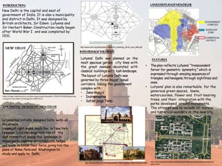
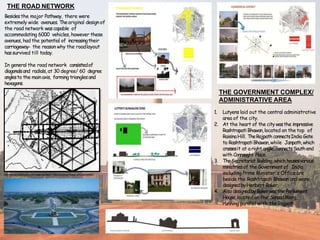
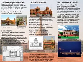
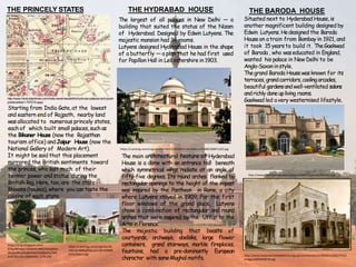
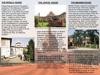
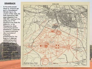
Lutyens designed New Delhi to be a spacious garden city with grand avenues and classical buildings set amidst green spaces. The layout included major roads like Rajpath connecting important landmarks. At the heart was Rashtrapati Bhawan on Raisina Hill. Nearby were the Secretariat buildings housing government ministries and the Parliament House. Princely states were allocated land starting from India Gate, where they built palaces in the styles of their regions. Prominent palaces included Hyderabad House designed like a butterfly, Baroda House in Anglo-Saxon style, and Jaipur House blending neo-classical and art deco styles.
Lutyens designed the city plan of New Delhi in the early 1900s after the capital of British India was moved from Calcutta. The plan featured wide avenues radiating from the central Vista. Key buildings included Rashtrapati Bhawan, the Secretariat, and Parliament House arranged along the central Vista. Princely states were allocated land to build palaces like Hyderabad House and Baroda House. The plan aimed to express British imperial power through grand neo-classical architecture and spacious layouts inspired by garden cities.
The document discusses the town planning of Delhi, including its geography, history of urbanization, population growth trends, and master plans implemented over time to accommodate increasing population. It provides details on the planning and development of Shahjahanabad during Mughal rule in the 17th century, including the layout of key areas like the Red Fort, Jama Masjid mosque, streets, neighborhoods, gardens and city walls. It also briefly outlines the subsequent development of Lutyens' Delhi after Delhi became the capital under British rule in the early 20th century.
Edwin Lutyens was the chief architect of New Delhi and designed several iconic buildings. He drew inspiration from local architectural styles and incorporated classical elements. His plan for New Delhi included wide roads laid out in a radial and hexagonal pattern. Key buildings like Rashtrapati Bhavan and India Gate borrowed from historical Indian styles like stupas and pavilions while also having elements of British architecture. The extensive planning of New Delhi considered topography, expansion needs, and traffic flow.
Chandigarh city planning by Le CorbusierAs Per Design
Le Corbusier was commissioned to design the new capital city of Chandigarh after the previous designers withdrew from the project. He retained the basic fan-shaped layout but converted it to a grid pattern with sectors. His design compressed the area while increasing density and respecting garden city principles. Chandigarh's plan was conceived as analogous to the human body, with defined areas serving as the head, heart, lungs, and other organs connected by a road network. Key features included sectors, a central business district, cultural/educational institutions, and open green spaces.
New Delhi was designed in the early 20th century to serve as the capital of British-controlled India. It was designed by British architects Edwin Lutyens and Herbert Baker in a grandiose colonial style inspired by Mughal architecture. Construction began in the 1920s on a symmetrical grid layout with wide boulevards, bisected by a central axis containing government buildings. Some of the most prominent architectural buildings included Rashtrapati Bhavan, the residence of the President of India, and the circular Parliament House, as well as Connaught Place, a commercial hub, and memorial structures like India Gate.
1. Lutyens designed New Delhi with wide roads and grand buildings laid out along symmetrical axes and boulevards. At the center was Rashtrapati Bhawan atop Raisina Hill, connected to India Gate via Rajpath.
2. Significant buildings like the Secretariat and Parliament House were placed strategically along the central axis. Connaught Place was designed as the commercial hub.
3. While the new imperial capital housed the elite, the common people lived in growing slums with inadequate housing and infrastructure due to large migration to the city.
Ancient Indian cities had sophisticated town planning systems based on Vedic texts. Towns were classified by size, from small villages to large capital cities, and by shape, including rectangular, square, circular and mystic symbolic designs. Larger cities had defined areas for temples, tanks, palaces, markets and residential zones for different castes. Streets were arranged in a grid pattern with widths specified in ancient units of measurement. Overall town planning principles focused on providing resources, security and social organization according to religious scripts.
The document describes the Tara Housing Group project in New Delhi, India. It was designed to provide affordable housing for middle-class families in a suburb of New Delhi. The design arranged single-family flats into united blocks around a central garden. This preserved privacy while providing access to shared open space. Each unit had an open terrace and maximized natural light and ventilation. While successful for its time, the design faces challenges today in accommodating increased living standards and development regulations around services, density, parking, and unit sizes. However, the social aspects of community space, interaction, and comfort remain relevant lessons for contemporary housing.
Settlement pattern of town (Varanasi) brief history of city evolve , settlement of institution and residents, concepts of the main ghats , master plan of Varanasi
Le Corbusier conceived the master plan for Chandigarh based on principles of modern architecture and urban planning. He designed the city layout with defined sectors for different functions, and placed the Capitol Complex at the northern tip to serve as the symbolic "head". The Complex houses the Secretariat, High Court and Legislative Assembly buildings separated by large plazas. Le Corbusier used modular dimensions, exposed concrete construction and bold primary colors in the Capitol Complex designs.
The document discusses the city planning of Chandigarh, India. It describes how Le Corbusier revised the initial plan by Albert Mayer, dividing the city into sectors of about 1200 by 800 meters. Each sector was designed as an autonomous neighborhood with housing, schools, shops, and recreational spaces. The capital complex was shifted to a higher ground and designed according to Le Corbusier's philosophies. While the planning approach was praised for creating a well-organized city, it was also criticized for being too standardized and not reflecting Indian culture and ways of life. The document analyzes the planning concepts and provides an overview of the development of Chandigarh.
The document discusses the history and planning of Lutyens' Delhi in India. It explains that the capital was moved from Calcutta to Delhi in 1911 for strategic political and historical reasons. Architect Edwin Lutyens was commissioned to design New Delhi, with the central administrative area featuring Rashtrapati Bhawan, Rajpath boulevard, the Secretariat buildings, and Parliament House laid out symmetrically around visual axes. The city plan also included residential areas for British officials and princely states. While the layout reflected European city designs, Indian architectural styles were incorporated into buildings. The planning of New Delhi did not adequately consider the needs of the existing city of Old Delhi.
The document provides details about the planning and development of Chandigarh, the new capital city of Punjab in India.
[1] The first master plan for Chandigarh was created by American planner Albert Mayer in the early 1950s. [2] When Le Corbusier was brought on to redesign the master plan, he retained the basic framework conceived by Mayer but replaced the neighborhood units with sectors. [3] Key features of Chandigarh designed by Le Corbusier include the open hand layout of the Capitol Complex, strict controls on housing and industry, and the use of parks and open spaces throughout the city.
Chandigarh is India's first planned city, designed by French architect Le Corbusier. It is a union territory serving as the joint capital of Punjab and Haryana. The city was planned on a grid system divided into sectors with strict architectural controls. Each sector is self-sufficient and includes amenities like schools and shops. The road network follows a "7Vs" system separating vehicles and pedestrians. Landscaping and open spaces were an important part of the original plan.
The capital of British India was shifted from Calcutta to Delhi in 1911. British architect Edwin Lutyens was tasked with planning and designing New Delhi. Lutyens designed an expansive garden city with wide avenues and classical buildings. Key elements of the design included the Rashtrapati Bhavan, Secretariat buildings, Parliament House, residential areas, and princely state palaces. However, the rapid growth of Old Delhi was not adequately planned for, leading to overcrowding and deterioration.
The document summarizes the planning and development of New Delhi as the capital city of British India. It discusses how Lutyens was commissioned to design and build New Delhi after the British decided to move the capital from Calcutta to Delhi in 1911. Key aspects of Lutyens' design included incorporating axial planning with major buildings along a central pathway (Rajpath), blending European and Indian architectural styles, and using geometric shapes like triangles and hexagons throughout the layout. The resulting new capital featured segregated areas and reflected social hierarchies through building placement.
Fatehpur Sikri was founded by Emperor Akbar in honor of the saint Shaikh Salim Chishti, who blessed Akbar with three sons. The city was planned as the new capital of the Mughal Empire, featuring impressive red sandstone architecture blending Hindu and Islamic styles. However, it was abandoned just 14 years later when the water supply ran dry. Today it remains remarkably preserved as an open air museum, a ghost city reflecting its former glory as the center of Mughal power and culture.
The document provides biographical information about British architect Laurie Baker (1917-2007). It discusses that he went to India in 1945 and lived/worked there for over 50 years, obtaining Indian citizenship in 1989. Some of his accomplishments include designing low-cost housing and medical facilities that incorporated local materials and techniques. He is renowned for promoting simplicity and cost-conscious construction. The document outlines several of Baker's architectural principles and design features, and provides examples of his works including homes, a computer center, and housing for tribal communities.
Edwin Lutyens was a British architect known for his work in England and India in the early 20th century. Some of his notable works include country houses in England using vernacular styles, as well as large secular and civic buildings. However, his most famous work is the Viceroy's House (now called Rashtrapati Bhavan) in New Delhi, built from 1913-1930. It combines elements of Mughal, European, and Indian architectural styles into a massive 340 room structure that remains the largest residence of a head of state in the world.
This document provides an overview of the history and development of Varanasi, India. It discusses the mythical origins of the city and its establishment along the Ganges River by Aryan settlers around 500 BC. The city grew as a religious center under the Gupta Empire from the 4th-6th centuries AD. Between the 8th-10th centuries, the city expanded further under the Pratiharas and Gahadavalas dynasties. During the Delhi Sultanate and Mughal periods, many mosques and tombs were built. In the 18th-19th centuries under the British, Varanasi became an important trade hub centered around silk and religious pilgrimage.
Urban squares have historically served as important public gathering spaces, often located at crossroads of trade routes. They function to provide shelter from traffic and represent psychological parking areas within cities. Factors that influence squares include surrounding buildings, proportions, entrance angles and central features. Squares can take different forms such as closed spaces enclosed by uniform buildings, dominated squares oriented around a focal point, nuclear squares with a central monument, grouped squares that combine into a whole, and amorphous squares without coherent shape. Over time, squares may evolve as new structures are added or old ones changed or destroyed.
Charles Correa was an Indian architect born in 1930 who pioneered modern architecture adapted to India's climate and resources. He is known for his "open-to-sky" designs that maximize natural light and ventilation. Notable works include low-cost tube housing, the Sonmarg and Kanchenjunga apartments in Mumbai, and cultural centers like the Jawahar Kala Kendra in Jaipur. Correa received many honors over his career for his contributions to architecture.
Charles-Edouard Jeanneret, better known as Le Corbusier, was a pioneering Swiss-French architect, designer, painter, urban planner, writer, and one of the pioneers of what is now called modern architecture. Some of his most notable works included the Villa Savoye in Paris, the city of Chandigarh in India, and the Unite d'Habitation in Marseille, France. He was influential in establishing the International Style of architecture and is widely regarded as one of the most influential architects of the 20th century.
Charles Correa was an Indian architect born in 1930. He received his education in India and the United States. Some of his notable works include the Kovalam Beach Resort in Kerala, the Gandhi Smarak Sangrahalaya in Ahmedabad, and the Kanchenjunga Apartments in Mumbai. Correa's works were influenced by modernism but adapted it to local contexts and vernacular styles. He emphasized principles like incrementality, identity, pluralism, and equity. Correa received many awards over his career and is considered one of India's most important architects.
This presentation talks in detail, about the ideas that went into designing one of the most beautiful urban design projects of India- The Central Vista of New Delhi.
The capital of British India was shifted from Calcutta to Delhi in 1911. British architect Edwin Lutyens was tasked with planning and designing New Delhi. Lutyens designed an expansive garden city with wide avenues and grand classical buildings. Key elements of the design included the central administrative area, with buildings like Rashtrapati Bhavan, Secretariat, and Parliament House. Lutyens also allocated land for princely states to construct palaces like Hyderabad House and Baroda House. However, the rapid growth of population in Old Delhi due to the new capital was not adequately planned for.
The document discusses colonial architecture in India, with a focus on Delhi and Bombay. It describes the prominent colonial architectural styles in India, including Gothic, Victorian, and Indo-Saracenic. It highlights some of the most notable buildings designed during the British colonial period, including Rashtrapati Bhavan, India Gate, Parliament House, and Central Secretariat in Delhi, as well as Chhatrapati Shivaji Terminus, Gateway of India, and Municipal Corporation Building in Bombay. It summarizes the contributions of British architects like Edwin Lutyens, Herbert Baker, and George Wittet to the architectural heritage of colonial India.
Connaught Place and India Gate are two iconic landmarks in Delhi designed by Sir Edwin Lutyens. Connaught Place is the central business district of Delhi, built in the 1930s as a circular complex housing shops and businesses. It features colonnaded walkways and was designed to blend European and Indian architectural styles. India Gate is a war memorial located near Rajpath, built in 1931 to commemorate Indian soldiers who died in World War I and other conflicts. It takes the form of a massive sandstone archway topped with sculptures and inscriptions.
Connaught Place in Delhi originated in the 1920s as a circular commercial development planned by Lutyens. It was envisioned as the central business district connecting New Delhi to Old Delhi. Construction began in 1929 and was completed over five years, resulting in two concentric circles of buildings forming three roads. Originally intended for both commercial and residential use, it became a prominent landmark and hub for Delhi's elite. Today, it remains an important commercial area and has expanded to include an underground market.
This project on Colonial Architecture in India will help us to :
Develop skills to gather data, investigate different view points and reach to a logical justification.
Appreciate the idea of architecture used by the Britishers.
Understand various features of British Architecture and respect the assimilation of different styles of buildings.
The document provides information on various tourist attractions in Delhi and New Delhi, India. It describes the Rashtrapati Bhawan Presidential Palace and India Gate memorial, Gurudwara Bangla Sahib Sikh shrine and Humayun's Tomb monument. It also mentions the Qutub Minar tower, Red Fort complex, Salimgarh Fort, Jama Masjid mosque, Laxminarayan Temple, Akshardham Temple, Raj Ghat memorial and Lotus Temple. Further sites described include Purana Qila fort, Tughlaqabad Fort, Jantar Mantar observatory, Safdarjung's Tomb, Sansad Bhavan parliament, Lodhi Gardens,
When the British first made inroads into India, little impact had been, was, or even intended on being made. Structures were mainly reflective of their functions, simple warehouses and a number of rather temporary administration facilities with residences remaining few in number, these kept to the traditional and vernacular. However, as British interests in India expanded, more permanent structures were required to facilitate the infrastructure of the new British Raj- symbols of their new status as the power seat; a sense of permanence and prominence.
Connaught Place is a large financial and commercial center in Delhi developed in the 1930s based on European architectural styles. It was designed with a circular central area surrounded by seven radial roads. Originally intended for commercial and residential use, it is now solely commercial and a major attraction in Delhi hosting many public buildings, shops, and offices.
Red fort and rastrapati bhavan compare and comparisionIHCSEM1
Both the Red Fort and Rashtrapati Bhavan are important historical sites located in Delhi. The Red Fort was constructed in the 17th century as the residence and administrative center of the Mughal Empire. Rashtrapati Bhavan currently serves as the official residence of the President of India. While one symbolizes the past Mughal kingdom, the other represents modern Indian democracy. Both structures provide insight into India's rich political history and culture.
its a presentation on garden cities comparing the case of chandigarh and lutyens city delhi do noy copy all rights are taken....
if you need we make goo and more better ppts than this call on 9975432591 also can whatsapp on the same number
City Palace in Jaipur was built between 1729-1732 AD by Maharaja Sawai Jai Singh II as the royal residence where the Maharaja reigned. The palace includes famous buildings like Chandra Mahal and Mubarak Mahal. It is located in the northeast part of Jaipur and has many courtyards and buildings. The architectural styles fuse Rajput, Mughal, and European influences. Today, Chandra Mahal is a museum housing artifacts from the royal family's history.
Under colonial rule in the late 18th century, Calcutta, Bombay, and Madras rose as Presidency cities and centers of British power, while many smaller cities and trading centers declined as trade shifted. Old regional powers also collapsed when local rulers were defeated. This led to the de-urbanization of cities like Machlipatnam, Surat, and Seringapatnam in the 19th century. After the 1857 rebellion, the British demolished parts of Shahjahanabad and filled canals to erase Delhi's Mughal past. They began constructing a new capital, New Delhi, as a contrast to the old city with broad streets and planned neighborhoods. Partition in 1947 led to massive population exchanges, as
The document summarizes key structures found across India, including palaces, temples, forts and monuments. It describes the Mysore Palace as the official residence of the royal family that ruled Mysore state. The Lotus Temple in Delhi is noted as a stunning modern structure that took 10 years to design. Hampi is recognized as a UNESCO World Heritage site containing the ruins of the Vijayanagara Empire capital. Several other historic structures are briefly outlined, including the Charminar mosque in Hyderabad, Qutub Minar in Delhi, Red Fort in Delhi, and Golkonda fort in Hyderabad.
This project will be very useful for us. In this project we highlight the importance of Delhi .
For Future :
We hope that when any new generation students will study this file then they explore the more information about the DELHI’s cities and its serious problems.
For present:
We also study about the various cities which is situated in Delhi and also know about the problems of monuments.
To Spread Awareness.
we Prepared ppt on our project. And also send official letter to high official of Delhi govt.
Delhi is the capital city of India located in northern India on the banks of the Yamuna River. It has a long history dating back to the 6th century BCE and has been ruled by several different empires and dynasties over the centuries. Today, Delhi is a large metropolis consisting of both Old Delhi and New Delhi, with over 12 million inhabitants. In preparation for hosting the 2010 Commonwealth Games, Delhi has undertaken major infrastructure projects such as expanding the metro system, building new hospitals and roads, and improving power supply and green spaces.
Rashtrapati Bhavan, a magnificent structure and the official house of the President of India, is situated at the western end of the Rajpath in New Delhi. One of India's most famous buildings, Rashtrapati Bhavan has seen a number of noteworthy occasions that have altered the course of Indian history.
Victorian architecture is characterized by the period of change between the mid-1800s to early 1900s in England. This era saw changes in technology, literature, art, women's rights, religion, fashion, and social structures. This sense of change was reflected heavily in the architectural styles of the period. Some popular Victorian styles included Jacobethan, Renaissance Revival, Neo-Grec, Romanesque Revival, Second Empire, Queen Anne, and Gothic Revival. These styles were also influential in architecture in colonial India, often fused with local Mughal and Indian elements in a style known as Indo-Saracenic. Major buildings exhibiting Victorian architecture were constructed in the cities of Kolkata, Delhi, Jaipur
The chapter Lifelines of National Economy in Class 10 Geography focuses on the various modes of transportation and communication that play a vital role in the economic development of a country. These lifelines are crucial for the movement of goods, services, and people, thereby connecting different regions and promoting economic activities.
Level 3 NCEA - NZ: A Nation In the Making 1872 - 1900 SML.pptHenry Hollis
The History of NZ 1870-1900.
Making of a Nation.
From the NZ Wars to Liberals,
Richard Seddon, George Grey,
Social Laboratory, New Zealand,
Confiscations, Kotahitanga, Kingitanga, Parliament, Suffrage, Repudiation, Economic Change, Agriculture, Gold Mining, Timber, Flax, Sheep, Dairying,
This presentation was provided by Rebecca Benner, Ph.D., of the American Society of Anesthesiologists, for the second session of NISO's 2024 Training Series "DEIA in the Scholarly Landscape." Session Two: 'Expanding Pathways to Publishing Careers,' was held June 13, 2024.
Chapter wise All Notes of First year Basic Civil Engineering.pptxDenish Jangid
Chapter wise All Notes of First year Basic Civil Engineering
Syllabus
Chapter-1
Introduction to objective, scope and outcome the subject
Chapter 2
Introduction: Scope and Specialization of Civil Engineering, Role of civil Engineer in Society, Impact of infrastructural development on economy of country.
Chapter 3
Surveying: Object Principles & Types of Surveying; Site Plans, Plans & Maps; Scales & Unit of different Measurements.
Linear Measurements: Instruments used. Linear Measurement by Tape, Ranging out Survey Lines and overcoming Obstructions; Measurements on sloping ground; Tape corrections, conventional symbols. Angular Measurements: Instruments used; Introduction to Compass Surveying, Bearings and Longitude & Latitude of a Line, Introduction to total station.
Levelling: Instrument used Object of levelling, Methods of levelling in brief, and Contour maps.
Chapter 4
Buildings: Selection of site for Buildings, Layout of Building Plan, Types of buildings, Plinth area, carpet area, floor space index, Introduction to building byelaws, concept of sun light & ventilation. Components of Buildings & their functions, Basic concept of R.C.C., Introduction to types of foundation
Chapter 5
Transportation: Introduction to Transportation Engineering; Traffic and Road Safety: Types and Characteristics of Various Modes of Transportation; Various Road Traffic Signs, Causes of Accidents and Road Safety Measures.
Chapter 6
Environmental Engineering: Environmental Pollution, Environmental Acts and Regulations, Functional Concepts of Ecology, Basics of Species, Biodiversity, Ecosystem, Hydrological Cycle; Chemical Cycles: Carbon, Nitrogen & Phosphorus; Energy Flow in Ecosystems.
Water Pollution: Water Quality standards, Introduction to Treatment & Disposal of Waste Water. Reuse and Saving of Water, Rain Water Harvesting. Solid Waste Management: Classification of Solid Waste, Collection, Transportation and Disposal of Solid. Recycling of Solid Waste: Energy Recovery, Sanitary Landfill, On-Site Sanitation. Air & Noise Pollution: Primary and Secondary air pollutants, Harmful effects of Air Pollution, Control of Air Pollution. . Noise Pollution Harmful Effects of noise pollution, control of noise pollution, Global warming & Climate Change, Ozone depletion, Greenhouse effect
Text Books:
1. Palancharmy, Basic Civil Engineering, McGraw Hill publishers.
2. Satheesh Gopi, Basic Civil Engineering, Pearson Publishers.
3. Ketki Rangwala Dalal, Essentials of Civil Engineering, Charotar Publishing House.
4. BCP, Surveying volume 1
Leveraging Generative AI to Drive Nonprofit InnovationTechSoup
In this webinar, participants learned how to utilize Generative AI to streamline operations and elevate member engagement. Amazon Web Service experts provided a customer specific use cases and dived into low/no-code tools that are quick and easy to deploy through Amazon Web Service (AWS.)
A Visual Guide to 1 Samuel | A Tale of Two HeartsSteve Thomason
These slides walk through the story of 1 Samuel. Samuel is the last judge of Israel. The people reject God and want a king. Saul is anointed as the first king, but he is not a good king. David, the shepherd boy is anointed and Saul is envious of him. David shows honor while Saul continues to self destruct.
LAND USE LAND COVER AND NDVI OF MIRZAPUR DISTRICT, UPRAHUL
This Dissertation explores the particular circumstances of Mirzapur, a region located in the
core of India. Mirzapur, with its varied terrains and abundant biodiversity, offers an optimal
environment for investigating the changes in vegetation cover dynamics. Our study utilizes
advanced technologies such as GIS (Geographic Information Systems) and Remote sensing to
analyze the transformations that have taken place over the course of a decade.
The complex relationship between human activities and the environment has been the focus
of extensive research and worry. As the global community grapples with swift urbanization,
population expansion, and economic progress, the effects on natural ecosystems are becoming
more evident. A crucial element of this impact is the alteration of vegetation cover, which plays a
significant role in maintaining the ecological equilibrium of our planet.Land serves as the foundation for all human activities and provides the necessary materials for
these activities. As the most crucial natural resource, its utilization by humans results in different
'Land uses,' which are determined by both human activities and the physical characteristics of the
land.
The utilization of land is impacted by human needs and environmental factors. In countries
like India, rapid population growth and the emphasis on extensive resource exploitation can lead
to significant land degradation, adversely affecting the region's land cover.
Therefore, human intervention has significantly influenced land use patterns over many
centuries, evolving its structure over time and space. In the present era, these changes have
accelerated due to factors such as agriculture and urbanization. Information regarding land use and
cover is essential for various planning and management tasks related to the Earth's surface,
providing crucial environmental data for scientific, resource management, policy purposes, and
diverse human activities.
Accurate understanding of land use and cover is imperative for the development planning
of any area. Consequently, a wide range of professionals, including earth system scientists, land
and water managers, and urban planners, are interested in obtaining data on land use and cover
changes, conversion trends, and other related patterns. The spatial dimensions of land use and
cover support policymakers and scientists in making well-informed decisions, as alterations in
these patterns indicate shifts in economic and social conditions. Monitoring such changes with the
help of Advanced technologies like Remote Sensing and Geographic Information Systems is
crucial for coordinated efforts across different administrative levels. Advanced technologies like
Remote Sensing and Geographic Information Systems
9
Changes in vegetation cover refer to variations in the distribution, composition, and overall
structure of plant communities across different temporal and spatial scales. These changes can
occur natural.
BIOLOGY NATIONAL EXAMINATION COUNCIL (NECO) 2024 PRACTICAL MANUAL.pptx
Lutyens Delhi
1. LUTYEN’S DELHI
SUBMITTED TO:
PROF. A. K. MANNA
BY:
AKSHAT KACHHAL
ANKIT SAINI
BADAL JAYKUMAR THOLIA
NAMAN JAIN
VAISHALI JAIN
VARUN JAIN
JIGME CHOGYEL
2. INTRODUCTION:
New Delhi is the capital and seat of
government of India. It is also a municipality
and district in Delhi. It was designed by
British architects, Sir Edwin Lutyens and
Sir Herbert Baker. Construction really began
after World War I and was completed by
1931.
https://image.slidesharecdn.com/planningconceptofnewdelhi-170522170746/95/planning-
concept-of-new-delhi-10-638.jpg?cb=1495473111
LANDUSEPLANOFNEWDELHI:
GOVERNMENT
COMPLEX
BUNGLOW
ZONE
COMMERCIAL
DISTRICT
THEINITIAL DESIGNOF NEWDELHI
Lutyens had initially designed Delhi with all
thestreets
crossingat right angles,much like in New York.
However, Lord Hardinge told him of the
duststormsthat sweep the landscape in
these parts, insisting onroundabouts,hedges
andtrees to break their force,giving him the
plans of Rome,Parisand Washington to
study and apply to Delhi.
http://www.wmf.org/sites/default/files/wmf_article/pg_38-43_new_delhi.pdf
Lutyens’ Delhi was planned on the
most spacious garden city lines with
the great avenues decorated with
classical buildings with lushlandscape.
Thelayout of Lutyens Delhi was
governed by three major visual
corridors, linking the government
complex with :
• JamaMasjid
• Indraprastha
• Safdarjungs Tomb
INTENTIONSOFTHELAYOUT:
http://www.archinomy.com/case-studies/1158/changing-image-of-lutyens-delhi
FEATURES
• Theplan reflects Lutyens’ “transcendent
fervor for geometric symmetry,” which is
expressed through amazing sequencesof
triangles andhexagons,through sightlines and
axes.
• Lutyens’ plan is also remarkable for the
generous green spaces, lawns,
watercourses, flower and fruit-bearing
trees, and their integration with the
parks developed around monuments.
• The attempt was to include all natural
and historical wonders in the new city.
http://www.postcolonialweb.org/india/art/architecture/colonial/seccomplex/col
umn1.html
3. THE ROAD NETWORK
Besidesthe major Pathway, there were
extremely wide avenues. Theoriginal design of
the road network wascapable of
accommodating 6000 vehicles, however these
avenues, had the potential of increasingtheir
carriageway- the reason why the roadlayout
hassurvived till today.
In general the road network consistedof
diagonalsand radials,at 30 degree/ 60 degree
anglesto the main axis, forming trianglesand
hexagons.
http://www.archinomy.com/case-studies/1158/changing-image-of-lutyens-delhi
THE GOVERNMENT COMPLEX/
ADMINISTRATIVE AREA
1. Lutyens laid out the central administrative
area of the city.
2. At the heart of the citywasthe impressive
Rashtrapati Bhawan,located on the top of
RaisinaHill. TheRajpath connectsIndia Gate
to RashtrapatiBhawan,while Janpath,which
crossesit at a right angle,connectsSouthend
with Connaught Place.
3. TheSecretariatBuilding,which housesvarious
ministries of the Governmentof India
including Prime Minister's Office are
beside the Rashtrapati Bhawan and were
designedbyHerbert Baker.
4. Also designedbyBakerwasthe Parliament
House,located on the SansadMarg,
running parallel with theRajpath.
4. THE RASHTRAPATI BHAWAN
https://media.gqindia.com/wp
content/uploads/2015/11/rash
trapati-bhavan-9_0_0-
768x768.jpg
https://www.exploreouting.com/images/poi_im
ages/ATTR_1232_1502195265_1.jpg
Lutyen's grandiose Government House
(RashtrapatiBhawan)- located on RaisinaHill,
and one of New Delhi's major thoroughfares,
Rajpath, connects it to the Purana Qila
Lord Hardinge chosethe RaisinaHill for
locating the viceroy’s palacebecause:
It wasawell drained.
Constituted of slopesandplains between the
ridge and theriver.
Its eastern and southern margins were
studdedwith monumentsof vanished empires. A
broad crescent from Shahjahanabad and Kotla
Firoz Shah,south to Tughlaqabad and the
Qutub with tombs of Safdarjung and Lodhis as
well asJantar Mantar in the foreground could
be viewed fromthe site.
https://i.pinimg
.com/originals/
7f/80/2c/7f802
c4fa15a8686ce
ec6c1a16e8bd2
9.jpg
THE SECRETARIAT
TheSecretariat Building wasdesigned by
architect Herbert Bakerin Indo-Saracenic
Revival architecture.
Much of the building is in classical
architectural style, yet it incorporated
Mughal andRajasthani architecture style and
motifs in its architecture.
Theseare visible in the use of Jali.
Another feature of the building is a
dome-like structure known asthe Chatri.
https://c8.alamy.com/comp/FB23XY/india-secretariat-building-in-new-delhi-FB23XY.jpg
Thestyle of architecture used in
Secretariat Building is unique to RaisinaHill.
In front of the main gatesonbuildings are
the four "dominion columns",given by Canada,
Australia, New Zealand and South Africa.
https://cdn9.dissolve.com/p/D256
_37_337/D256_37_337_1200.jpg
http://simonfieldhouse.com/wp-
content/uploads/2016/05/Secretariat-
Building-New-Delhi-elevation-
1024x992.jpg
THE PARLIAMENT HOUSE
TheParliament Houswas designed by
Edwin LutyensandHerbert Baker.
It wasbuilt with indigenousmaterials and
by Indian labour and the architecture of
the building bears aclose imprint of the
Indian tradition.
Thelayout of fountainsboth inside and
outside the building, the useof Indian
symbols,the "Chhajjas” and the varied
forms of "Jali" in marble are reminders
of the story of the craftsmanship
displayed in ancient monuments and
memorials.
http://1.bp.blogspot.com/-
9e7ewl2XDBk/VEUHBNcQOTI/AAAAAAAAGv4/5yUpbZgGtmc/s1600/Parliament
%2BHouse%2BSansad%2BBhavan%2BDelhi%2BPixelated%2BMemories%2BSahil
%2BAhuja%2B(5).jpg
https://reliableacademy.com/assets/media/upload/current-affairs/parliament-
passes-indian-institute-of-petroleum--energy-bill-2017/indian-parliment.jpg
5. Starting from India Gate, at the lowest
and eastern end of Rajpath, nearby land
wasallocated to numerous princely states,
each of which built small palaces, such as
the Bikaner House (now the Rajasthan
tourism office) andJaipur House (now the
National Gallery of Modern Art).
It might be said that this placement
mirrored the British sentiments toward
the princes, who lost much of their
former power and status during the
British Raj. Here, too,are the state
Bhavans(houses), where you can taste the
cuisine of each state.
THE PRINCELY STATES
http://www.hindustantimes.com/india-news/newdelhi/of-princes-palaces-and-plush-
points/article1-707274.aspx
https://i.pinimg.com/originals/36
/00/a9/3600a956cca11187450800
b15a1feec2.jpg
https://2.bp.blogspot.com/-
970y7BFeqqc/V0HR4YLHBXI/AAAAAAA
AKo0/cBtIqJbtq6kPS4fcNHDpxP1c1HlE
mzEFACLcB/s1600/IMG_1279.JPG
THE HYDRABAD HOUSE
The largest of all palaces in New Delhi — a
building that suited the status of the Nizam
of Hyderabad. Designed by Edwin Lutyens. The
majestic mansion had 36 rooms.
Lutyens designed Hyderabad House in the shape
of a butterfly — a plan that he had first used
for Papillon Hall in Leicestershire in 1903.
https://i.pinimg.com/originals/00/19/35/0019351cdc4366ce5d7dd853fd871162.jpg
The main architectural feature of Hyderabad
House is a dome with an entrance hall beneath
which symmetrical wings radiate at an angle of
fifty-five degrees. Its round arches flanked by
rectangular openings to the height of the impost
was inspired by the Pantheon in Rome, a city
where Lutyens stayed in 1909. For the first
floor windows of the grand place, Lutyens
chose a combination of rectangular and round
arches that were inspired by the Uffizi to the
Arnoin Florence.
The majestic building that boasts of
courtyards, archways, obelisks, large flower
containers, grand stairways, marble fireplaces,
fountains, had a pre-dominantly European
character with someMughal motifs.
Situated next to Hyderabad House, is
another magnificent building designed by
Edwin Lutyens. Hedesigned the Baroda
Houseon atrain from Bombay in 1921, and
it took 15 years to build it. TheGaekwad
of Baroda , who waseducated in England,
wanted his palace in New Delhi to be
Anglo-Saxoninstyle.
Thegrand Baroda Housewas known for its
terraces, grandcorridors,coolingarcades,
beautiful gardensandwell-ventilated salons
andrichlydoneupliving rooms.
Gaekwad led avery westernised lifestyle.
THE BARODA HOUSE
http://www.lutyenstrustexhibitions.org.uk/communities/4/004/012/082/974//
images/4603646070.jpg
http://www.historyofvadodara.in/wp-content/uploads/Pavilion.jpg
6. Patiala Housewas formerly the palatial
residence of the Maharaja of Patiala (in
Punjab). part of central vista, this
building, built in the 1930s, hasacentral
dome with a butterfly layout, similar to
other buildings o the Lutyens zone.
Todayit housesthe district Courts
complex for New Delhi District. 'A
double Vtoreyed building, the central
portion isemphasizedwith a domedpavilion
onthe terrace andprojection porchover
the upperstorey,there isa projecting
chajja running the entire length of the old
building. It hasseeninteresting
occupants ever since the Maharaja
vacatedit.
THE PATIALA HOUSE
http://www.delhi.gov.in/wps/wcm/connect/doit_session/Session+Judge/Home/Delhi
+District+Courts/Patiala+House
THE JAIPUR HOUSE
https://www.fabhotels.com/blog/wp-content/uploads/2018/07/1000x650-60.jpg
Jaipur House(National Gallery of Modern
Art) is located diametrically opposite
Hyderabad House. Likeother princes’
residences, the building was also designedin
the shapeof a butterfly with a central
dome. But very few people know that it
was British architect Charles Blomfield,
who designed the building. It was designed
in amix of neo-classical and Art Deco
style. Thebutterfly-shaped buildinghastwo
symmetrical‘wings’radiating from the
central court.
Twosimilar wingsradiate towards the back
facingthe gardens.Thefaçade of this
comparatively austere palace ismarkedby
two levelsof small,vertical, slit-like windows.
A continuous sunshadeor ‘chajja’ in redstone
capsthe entire façade.Thebuilding has
arched openingsframed byRajput columns.
THE BIKANER HOUSE
Bikaner House is used as a boutique art
and cultural hub. There are multiple
spaces for different events. The
courtyard or Chandni Bagh is designed
to be used as a concert venue, while the
adjoining baithak is perfect space to
host small events. There's even a gallery
to showcase art. A permanent feature is
the design shop, Vayu, run by designer
Vivek Sahani. Clearly, the restoration
has given a new lease of life to the regal
building. AT Pandara Flats, India Gate,
New Delhi
Bikaner House is a princely house
located in New Delhi designed by. It is
a sprawling building now belonging to
the Rajasthan government within
walking distance of India Gate.
It is spread over an 8 acre plot
in Lutyens' Delhi. Among all the
princely residences, Bikaner House was
the least grand in design, as it was
more like a bungalow than a palace.
https://3.bp.blogspot.com/-
ojL7qqntPts/WHwxM4QuKOI/AAAAAAAANTk/z9NnR_UvF8s6eICA-
qERxu7mkqfZDOYjgCLcB/s1600/bikaner%2Bhouse.png
7. • In this whole process
almost no attention was
paid to theproblemsof
OldDelhi. Dueto the
creation ofNew Delhi, Old
Delhi experienced a28%
surgein population from
1916-1926 resulting in the
spilling over of the
population from inside the
walledcity to the
Paharganj area, whose
restructuring waslater
abandoned by Lutyens due
to resourceconstraints.
• Also, no provision of
housing was
premeditated for the
large no. of skilled and
unskilledworkerswhich
immigrated in for the
construction work of
NewDelhi.
• This negligence of the
planners towards Old
Delhi resulted in its
transformation to a large
slumarea through
deterioration and
dilapidation.
DRAWBACK
http://commons.wikimedia.org/wiki/File:Map_of_Lutyens'_proj ected_Imperial_Delhi,_from_the_Encyclopedia_Britannica,_11t