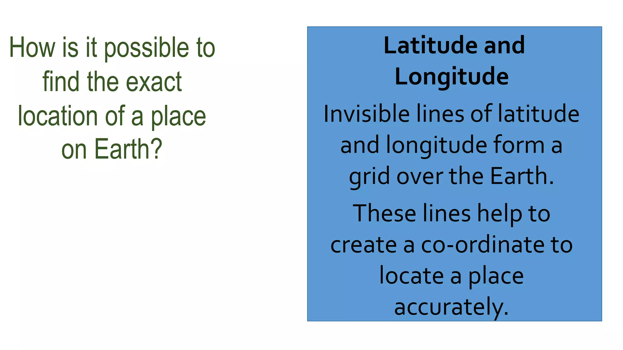
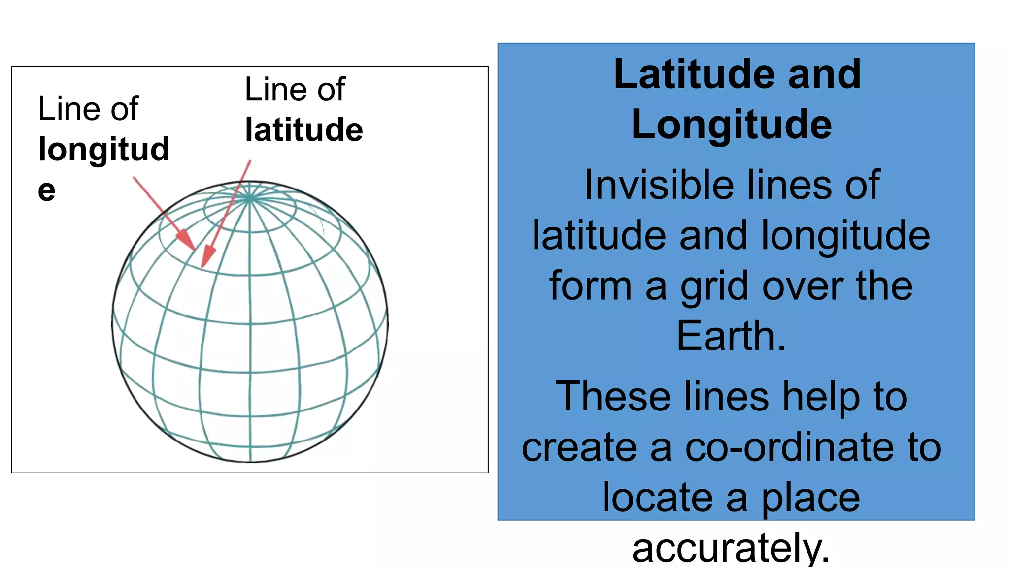
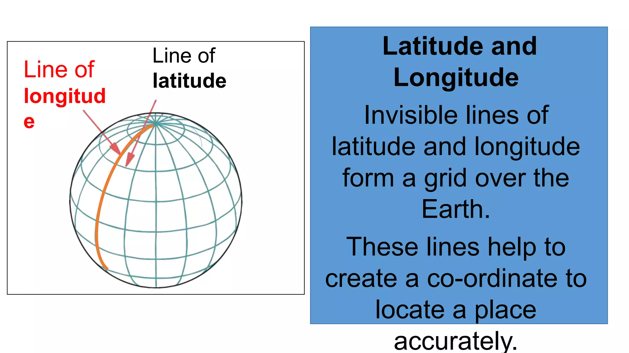
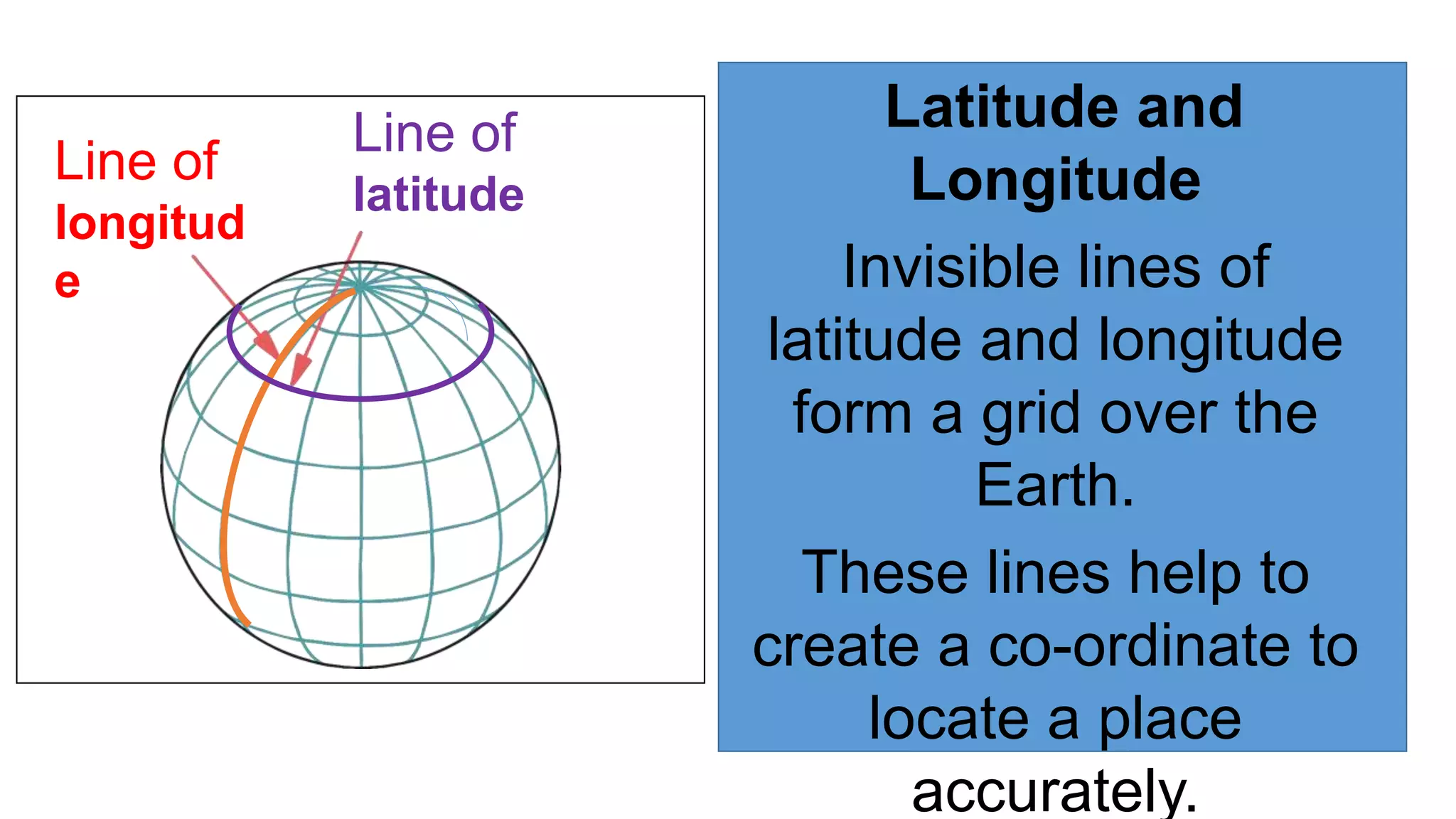
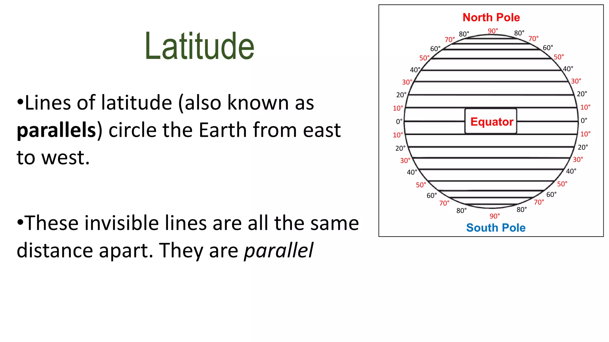
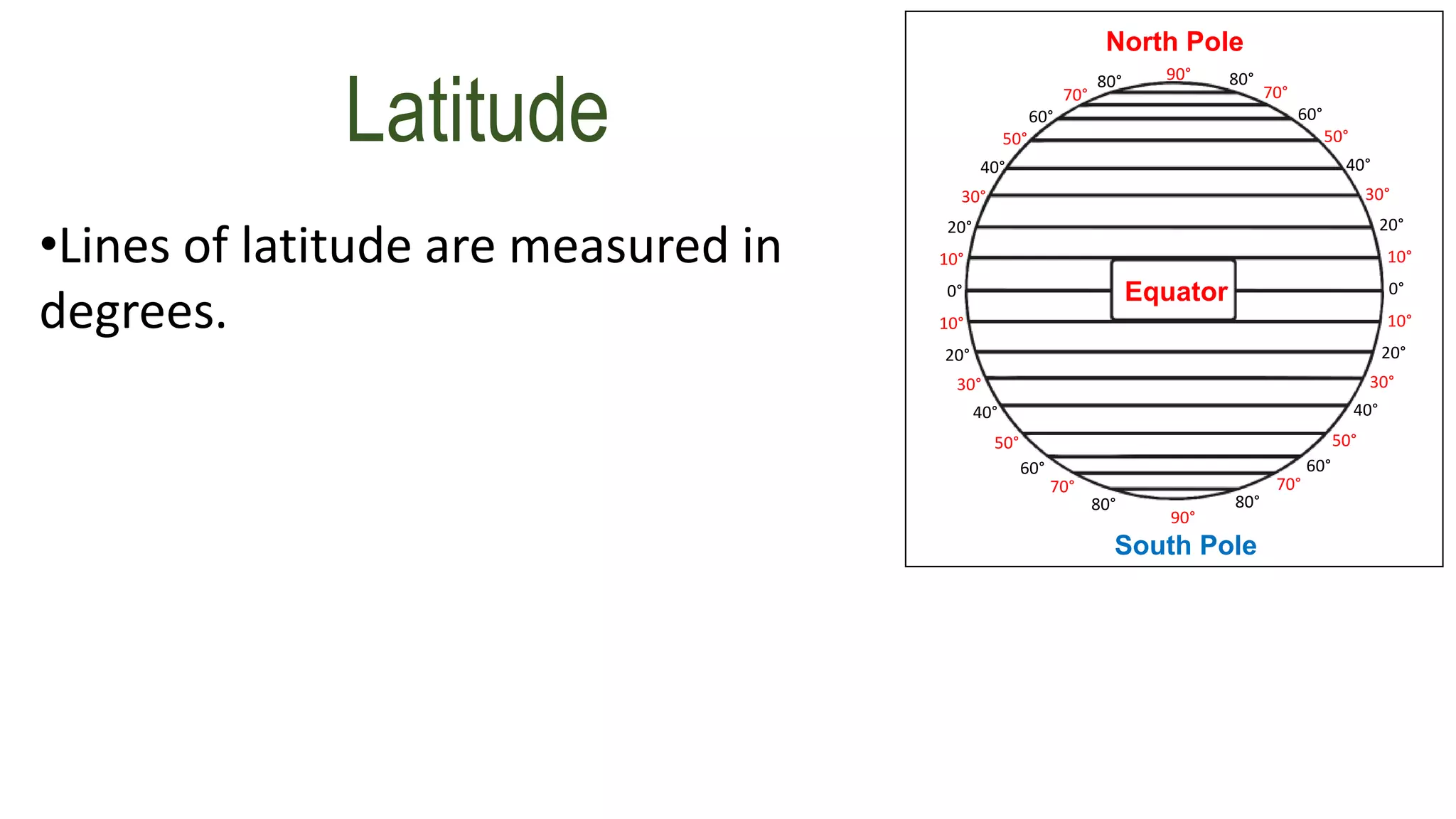
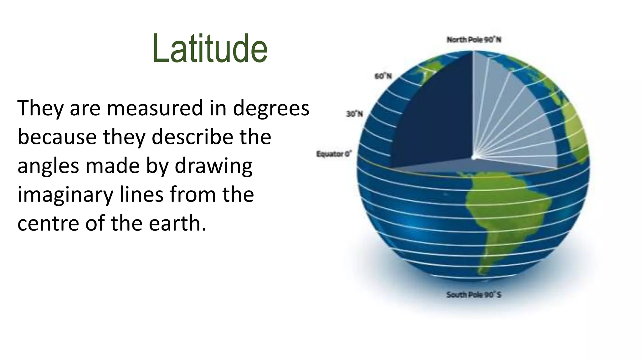
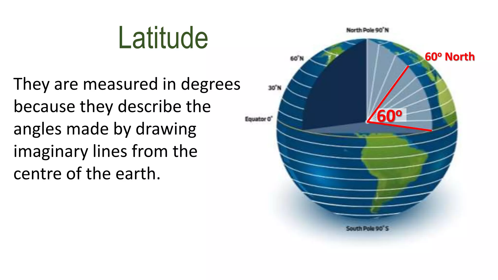
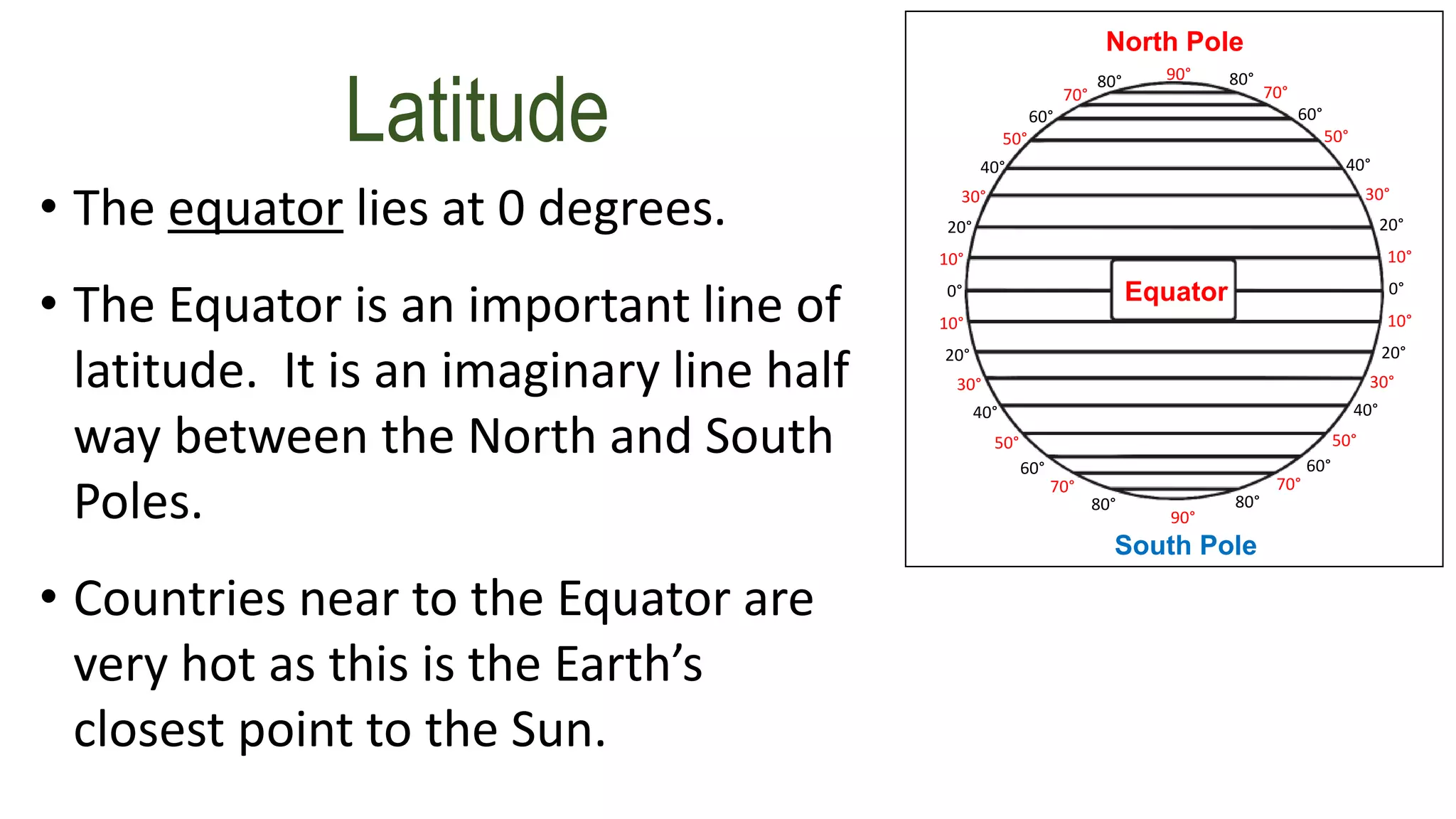
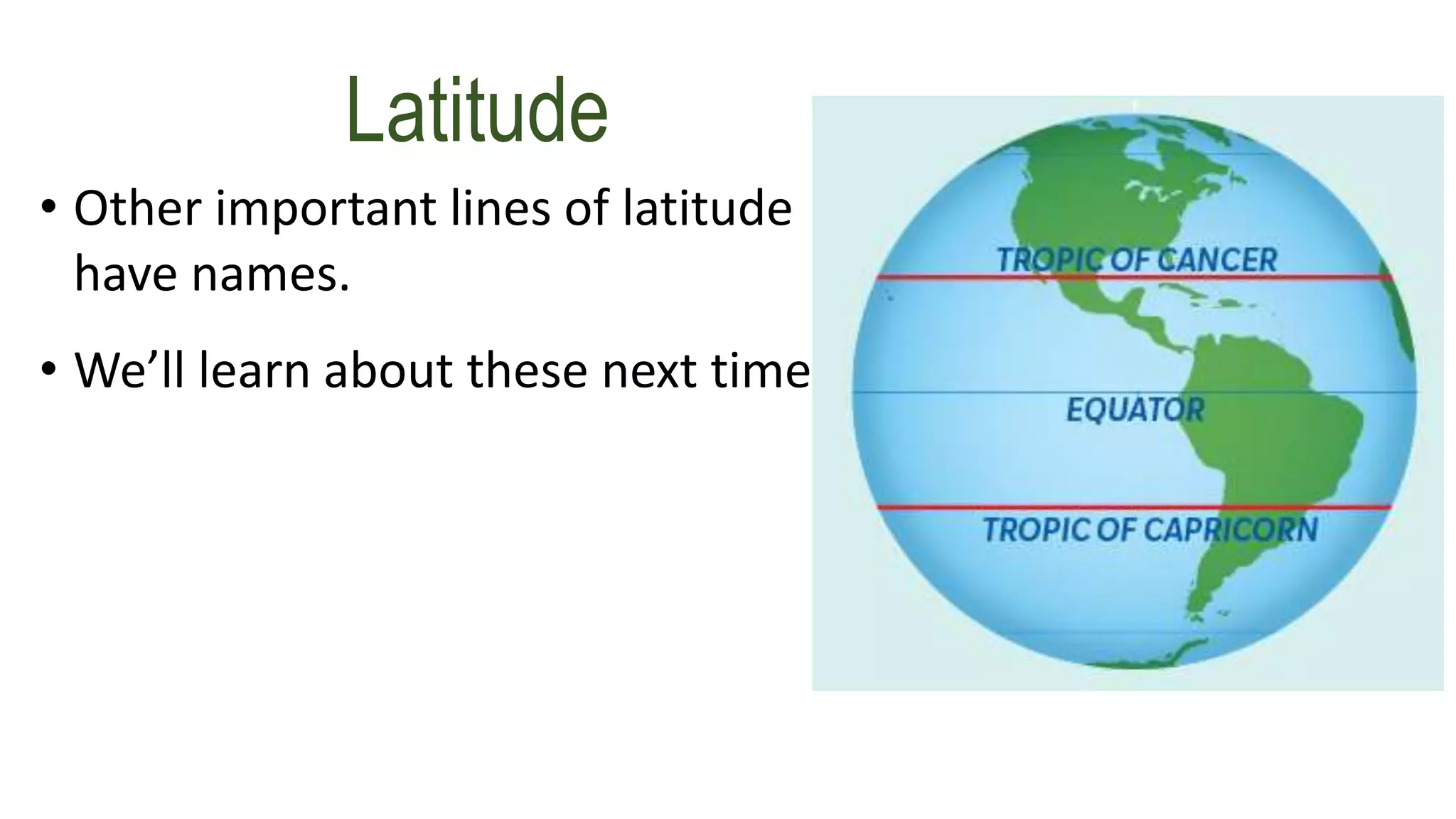
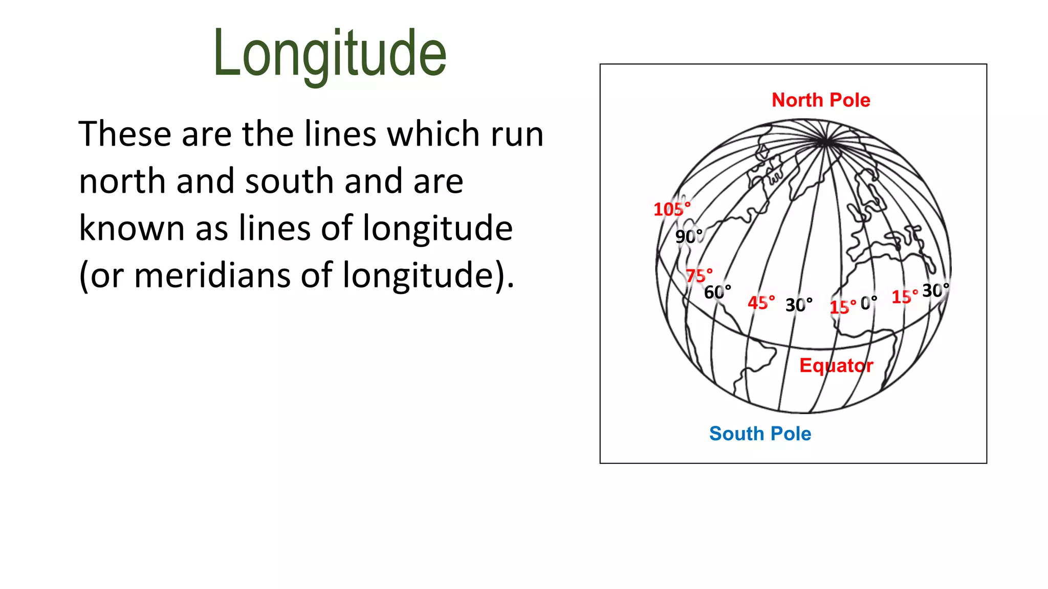
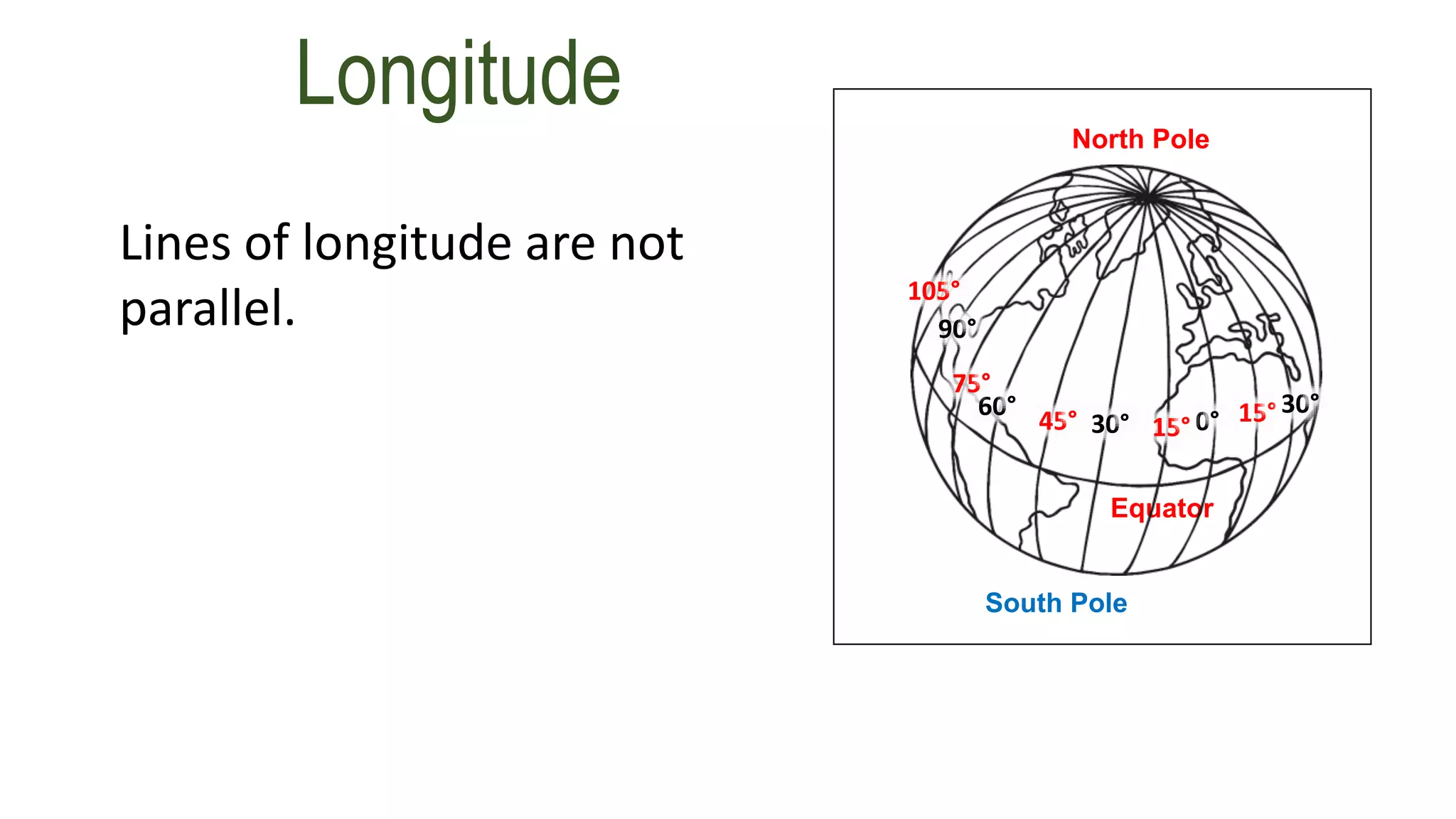
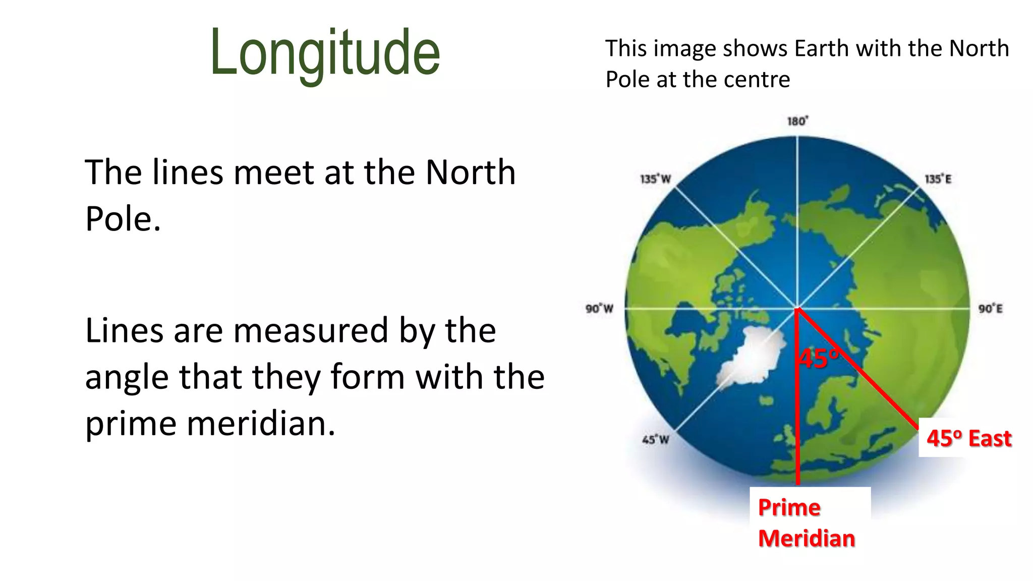
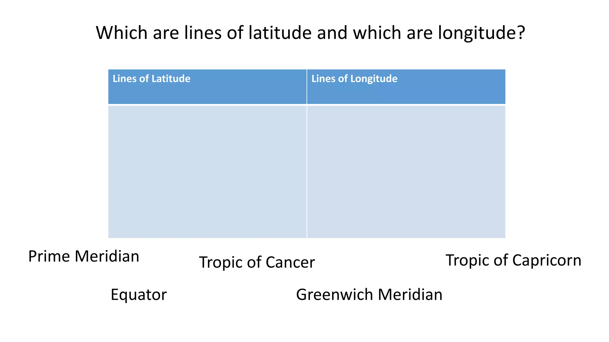
How to describe your
position anywhere in
the world...
...using latitude and
longitude.
Longitude and
Latitude
Before we entered into lockdown, you may
remember the words longitude and latitude
being mentioned. We are going to spend our
first geography lesson this term recapping
these terms and what they mean.
How is it possible to
find the exact
location of a place
on Earth?
How is it possible to
find the exact
location of a place
on Earth?
Latitude and
Longitude
Invisible lines of latitude
and longitude form a
grid over the Earth.
These lines help to
create a co-ordinate to
locate a place
accurately.
Latitude and
Longitude
Invisible lines of
latitude and longitude
form a grid over the
Earth.
These lines help to
create a co-ordinate to
locate a place
accurately.
Line of
longitud
e
Line of
latitude
Latitude and
Longitude
Invisible lines of
latitude and longitude
form a grid over the
Earth.
These lines help to
create a co-ordinate to
locate a place
accurately.
Line of
longitud
e
Line of
latitude
Latitude and
Longitude
Invisible lines of
latitude and longitude
form a grid over the
Earth.
These lines help to
create a co-ordinate to
locate a place
accurately.
Line of
longitud
e
Line of
latitude
•Lines of latitude (also known as
parallels) circle the Earth from east
to west.
•These invisible lines are all the same
distance apart. They are parallel
South Pole
North Pole
Equator
70°
60°
50°
40°
30°
20°
10°
0°
80°
10°
20°
30°
40°
50°
60°
70°
80°
90°
70°
60°
50°
40°
30°
20°
10°
0°
80°
10°
20°
30°
40°
50°
60°
70°
80°
90°
Latitude
•Lines of latitude are measured in
degrees.
South Pole
North Pole
Equator
70°
60°
50°
40°
30°
20°
10°
0°
80°
10°
20°
30°
40°
50°
60°
70°
80°
90°
70°
60°
50°
40°
30°
20°
10°
0°
80°
10°
20°
30°
40°
50°
60°
70°
80°
90°
Latitude
Latitude
They are measured in degrees
because they describe the
angles made by drawing
imaginary lines from the
centre of the earth.
Latitude
They are measured in degrees
because they describe the
angles made by drawing
imaginary lines from the
centre of the earth.
60o
60o North
• Like any angle, each degree of latitude
is separated into smaller divisions called
minutes.
• There are 60 minutes in 1 degree.
• Each minute is divided into 60 seconds
South Pole
North Pole
Equator
70°
60°
50°
40°
30°
20°
10°
0°
80°
10°
20°
30°
40°
50°
60°
70°
80°
90°
70°
60°
50°
40°
30°
20°
10°
0°
80°
10°
20°
30°
40°
50°
60°
70°
80°
90°
Latitude
• The equator lies at 0 degrees.
• The Equator is an important line of
latitude. It is an imaginary line half
way between the North and South
Poles.
• Countries near to the Equator are
very hot as this is the Earth’s
closest point to the Sun.
South Pole
North Pole
Equator
70°
60°
50°
40°
30°
20°
10°
0°
80°
10°
20°
30°
40°
50°
60°
70°
80°
90°
70°
60°
50°
40°
30°
20°
10°
0°
80°
10°
20°
30°
40°
50°
60°
70°
80°
90°
Latitude
• Other important lines of latitude
have names.
• We’ll learn about these next time
Latitude
Longitude
These are the lines which run
north and south and are
known as lines of longitude
(or meridians of longitude).
South Pole
North Pole
Equator
0°15°
15° 30°
30°45°
60°
75°
90°
105°
Longitude
Lines of longitude are not
parallel.
South Pole
North Pole
Equator
0°15°
15° 30°
30°45°
60°
75°
90°
105°
Longitude
The Prime Meridian or
Greenwich Meridian line is a
line of longitude at 0 degrees.
It passes right through
Greenwich in London. South Pole
North Pole
Equator
0°15°
15° 30°
30°45°
60°
75°
90°
105°
Longitude
The Prime Meridian or
Greenwich Meridian line is a
line of longitude at 0 degrees.
It passes right through
Greenwich in London. South Pole
North Pole
Equator
0°15°
15° 30°
30°45°
60°
75°
90°
105°
Longitude
These lines are measured in
degrees in the same way as
the lines of latitude.
South Pole
North Pole
Equator
0°15°
15° 30°
30°45°
60°
75°
90°
105°
Longitude
The lines meet at the North
Pole.
Lines are measured by the
angle that they form with the
prime meridian.
This image shows Earth with the North
Pole at the centre
45o
45o East
Prime
Meridian
Task 1:
• In your own words, explain your understanding of Latitude and
Longitude in as much detail as you can. Followed by a paragraph
explaining Longitude.
• After you have completed your paragraphs, draw a table in your book
to complete the task on the next page.
Lines of Latitude Lines of Longitude
Which are lines of latitude and which are longitude?
Prime Meridian
Equator
Tropic of Cancer
Greenwich Meridian
Tropic of Capricorn
How do we use this information to locate a place?
• We use numbers and letters to create a co-ordinate.
• Within the co-ordinate, the ° stands for degrees and the
‘ stands for minutes.
• The letters relate to north, south, east or west and are
shown as capitals.
• The latitude is always given first.
• To locate Florida, USA using this principle we would say
it has the following
co-ordinates: 28°00'N 82°00'W.
Satellite Navigation systems, or ‘Sat
Navs’ as they are sometimes called,
allow you to input latitude and
longitude co-ordinates instead of an
address.
These co-ordinates will get you to
your destination just as easily.
How do we use this information to locate a place?
Your Task:
Can you find destinations using co-ordinates?
Using Google Maps, type into the search engine the following co-
ordinates to find the destinations. Once you have found the five
destinations email them to your teacher.
1. 52.380357, -0.692595
2. 52.301541, -0.618557
3. -35.280709, 149.128641
4. 41.381073, 2.122895
5. 51.538810, -0.016625
Top Tip – Take care when copying the co-ordinates across, it may help to write them
down beforehand.
Extension: Challenge your friend to finding the destination of a place, using co-ordinates.
Send them by email, or use Google Classroom!

Longitude and latitude revision copy2

  • 2.
    How to describeyour position anywhere in the world... ...using latitude and longitude.
  • 3.
  • 4.
    Before we enteredinto lockdown, you may remember the words longitude and latitude being mentioned. We are going to spend our first geography lesson this term recapping these terms and what they mean.
  • 5.
    How is itpossible to find the exact location of a place on Earth?
  • 6.
    How is itpossible to find the exact location of a place on Earth? Latitude and Longitude Invisible lines of latitude and longitude form a grid over the Earth. These lines help to create a co-ordinate to locate a place accurately.
  • 7.
    Latitude and Longitude Invisible linesof latitude and longitude form a grid over the Earth. These lines help to create a co-ordinate to locate a place accurately. Line of longitud e Line of latitude
  • 8.
    Latitude and Longitude Invisible linesof latitude and longitude form a grid over the Earth. These lines help to create a co-ordinate to locate a place accurately. Line of longitud e Line of latitude
  • 9.
    Latitude and Longitude Invisible linesof latitude and longitude form a grid over the Earth. These lines help to create a co-ordinate to locate a place accurately. Line of longitud e Line of latitude
  • 10.
    •Lines of latitude(also known as parallels) circle the Earth from east to west. •These invisible lines are all the same distance apart. They are parallel South Pole North Pole Equator 70° 60° 50° 40° 30° 20° 10° 0° 80° 10° 20° 30° 40° 50° 60° 70° 80° 90° 70° 60° 50° 40° 30° 20° 10° 0° 80° 10° 20° 30° 40° 50° 60° 70° 80° 90° Latitude
  • 11.
    •Lines of latitudeare measured in degrees. South Pole North Pole Equator 70° 60° 50° 40° 30° 20° 10° 0° 80° 10° 20° 30° 40° 50° 60° 70° 80° 90° 70° 60° 50° 40° 30° 20° 10° 0° 80° 10° 20° 30° 40° 50° 60° 70° 80° 90° Latitude
  • 12.
    Latitude They are measuredin degrees because they describe the angles made by drawing imaginary lines from the centre of the earth.
  • 13.
    Latitude They are measuredin degrees because they describe the angles made by drawing imaginary lines from the centre of the earth. 60o 60o North
  • 14.
    • Like anyangle, each degree of latitude is separated into smaller divisions called minutes. • There are 60 minutes in 1 degree. • Each minute is divided into 60 seconds South Pole North Pole Equator 70° 60° 50° 40° 30° 20° 10° 0° 80° 10° 20° 30° 40° 50° 60° 70° 80° 90° 70° 60° 50° 40° 30° 20° 10° 0° 80° 10° 20° 30° 40° 50° 60° 70° 80° 90° Latitude
  • 15.
    • The equatorlies at 0 degrees. • The Equator is an important line of latitude. It is an imaginary line half way between the North and South Poles. • Countries near to the Equator are very hot as this is the Earth’s closest point to the Sun. South Pole North Pole Equator 70° 60° 50° 40° 30° 20° 10° 0° 80° 10° 20° 30° 40° 50° 60° 70° 80° 90° 70° 60° 50° 40° 30° 20° 10° 0° 80° 10° 20° 30° 40° 50° 60° 70° 80° 90° Latitude
  • 16.
    • Other importantlines of latitude have names. • We’ll learn about these next time Latitude
  • 17.
    Longitude These are thelines which run north and south and are known as lines of longitude (or meridians of longitude). South Pole North Pole Equator 0°15° 15° 30° 30°45° 60° 75° 90° 105°
  • 18.
    Longitude Lines of longitudeare not parallel. South Pole North Pole Equator 0°15° 15° 30° 30°45° 60° 75° 90° 105°
  • 19.
    Longitude The Prime Meridianor Greenwich Meridian line is a line of longitude at 0 degrees. It passes right through Greenwich in London. South Pole North Pole Equator 0°15° 15° 30° 30°45° 60° 75° 90° 105°
  • 20.
    Longitude The Prime Meridianor Greenwich Meridian line is a line of longitude at 0 degrees. It passes right through Greenwich in London. South Pole North Pole Equator 0°15° 15° 30° 30°45° 60° 75° 90° 105°
  • 21.
    Longitude These lines aremeasured in degrees in the same way as the lines of latitude. South Pole North Pole Equator 0°15° 15° 30° 30°45° 60° 75° 90° 105°
  • 22.
    Longitude The lines meetat the North Pole. Lines are measured by the angle that they form with the prime meridian. This image shows Earth with the North Pole at the centre 45o 45o East Prime Meridian
  • 23.
    Task 1: • Inyour own words, explain your understanding of Latitude and Longitude in as much detail as you can. Followed by a paragraph explaining Longitude. • After you have completed your paragraphs, draw a table in your book to complete the task on the next page.
  • 24.
    Lines of LatitudeLines of Longitude Which are lines of latitude and which are longitude? Prime Meridian Equator Tropic of Cancer Greenwich Meridian Tropic of Capricorn
  • 25.
    How do weuse this information to locate a place? • We use numbers and letters to create a co-ordinate. • Within the co-ordinate, the ° stands for degrees and the ‘ stands for minutes. • The letters relate to north, south, east or west and are shown as capitals. • The latitude is always given first. • To locate Florida, USA using this principle we would say it has the following co-ordinates: 28°00'N 82°00'W.
  • 26.
    Satellite Navigation systems,or ‘Sat Navs’ as they are sometimes called, allow you to input latitude and longitude co-ordinates instead of an address. These co-ordinates will get you to your destination just as easily. How do we use this information to locate a place?
  • 27.
    Your Task: Can youfind destinations using co-ordinates? Using Google Maps, type into the search engine the following co- ordinates to find the destinations. Once you have found the five destinations email them to your teacher. 1. 52.380357, -0.692595 2. 52.301541, -0.618557 3. -35.280709, 149.128641 4. 41.381073, 2.122895 5. 51.538810, -0.016625 Top Tip – Take care when copying the co-ordinates across, it may help to write them down beforehand. Extension: Challenge your friend to finding the destination of a place, using co-ordinates. Send them by email, or use Google Classroom!