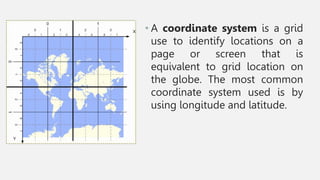
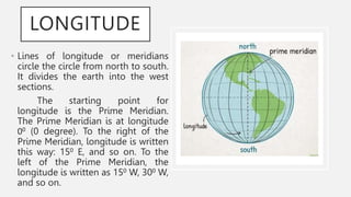
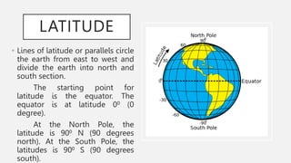
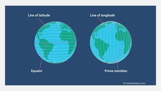
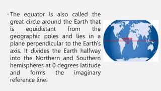
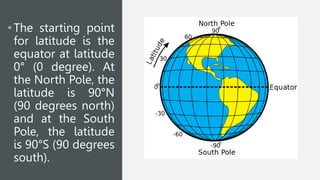
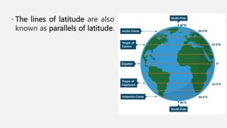
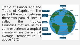
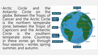
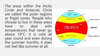
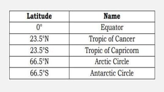
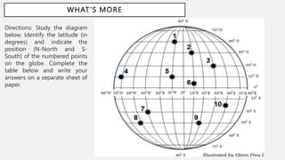
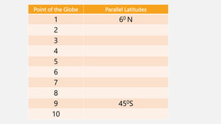
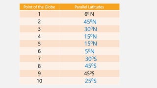
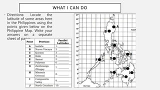
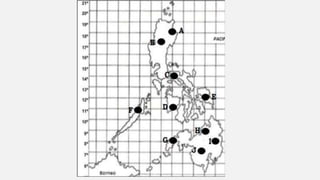
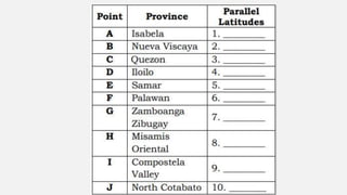
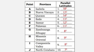
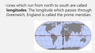
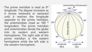
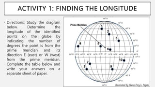
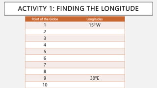
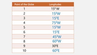
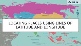
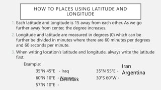
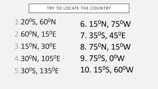
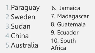
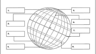
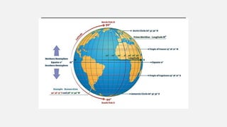
LOCATING PLACES USING
COORDINATE SYSTEM
Week 1-Quarter 4
DEMONSTRATE HOW PLACES ON
EARTH MAY BE LOCATED USING
COORDINATES
• A coordinate system is a grid
use to identify locations on a
page or screen that is
equivalent to grid location on
the globe. The most common
coordinate system used is by
using longitude and latitude.
LONGITUDE
• Lines of longitude or meridians
circle the circle from north to south.
It divides the earth into the west
sections.
The starting point for
longitude is the Prime Meridian.
The Prime Meridian is at longitude
00 (0 degree). To the right of the
Prime Meridian, longitude is written
this way: 150 E, and so on. To the
left of the Prime Meridian, the
longitude is written as 150 W, 300 W,
and so on.
LATITUDE
• Lines of latitude or parallels circle
the earth from east to west and
divide the earth into north and
south section.
The starting point for
latitude is the equator. The
equator is at latitude 00 (0
degree).
At the North Pole, the
latitude is 900 N (90 degrees
north). At the South Pole, the
latitudes is 900 S (90 degrees
south).
•The equator is also called the
great circle around the Earth that
is equidistant from the
geographic poles and lies in a
plane perpendicular to the Earth's
axis. It divides the Earth halfway
into the Northern and Southern
hemispheres at 0 degrees latitude
and forms the imaginary
reference line.
• The starting point
for latitude is the
equator at latitude
0° (0 degree). At
the North Pole, the
latitude is 90°N
(90 degrees north)
and at the South
Pole, the latitude
is 90°S (90 degrees
south).
• The lines of latitude are also
known as parallels of latitude.
•Tropic of Cancer and the
Tropic of Capricorn. The
part of the world between
these two parallel lines is
called the tropics.
Countries that are in this
zone experience a tropical
climate where the annual
average temperature is
above 18°C.
•Arctic Circle and the
Antarctic Circle on the
globe. Between the Tropic of
Cancer and the Arctic Circle
is the northern temperate
zone; between the Tropic of
Capricorn and the Antarctic
Circle is the southern
temperate zone. Countries
in these zones go through
four seasons – winter, spring
summer, and autumn.
•The areas within the Arctic
Circle and Antarctic Circle
are called the polar regions
or frigid zones. People who
choose to live in these areas
have to deal with
temperatures that never go
above 10°C. It is cold all
year round and even during
the summer months, it does
not feel like summer at all.
To sum up, the closer the latitude is to
the equator, the warmer the climate. The
closer it is to the poles, the colder. Thus,
it is clear that there is a relationship
between the latitude of a place and the
climate it experiences.
WHAT’S MORE
Directions: Study the diagram
below. Identify the latitude (in
degrees) and indicate the
position (N-North and S-
South) of the numbered points
on the globe. Complete the
table below and write your
answers on a separate sheet of
paper.
Point of the Globe Parallel Latitudes
1 60 N
2
3
4
5
6
7
8
9 450S
10
Point of the Globe Parallel Latitudes
1 60 N
2
3
4
5
6
7
8
9 450S
10
450N
300N
150N
150N
50N
300S
450S
250S
WHAT I CAN DO
• Directions: Locate the
latitude of some areas here
in the Philippines using the
points given below on the
Philippine Map. Write your
answers on a separate
sheet of paper.
180
170
140
110
120
110
80
90
80
70
•Lines which run from north to south are called
longitudes. The longitude which passes through
Greenwich, England is called the prime meridian.
• The prime meridian is read as 0º
longitude. The degree increases as
it moves westward or eastward
until it reaches the longitude
opposite to the prime meridian,
the antemeridian (read as 180 º
longitudes). The prime meridian
and antemeridian divide the globe
into its eastern and western
hemispheres. The right side of the
prime meridian is the eastern
hemisphere while the left side is
the western hemisphere.
ACTIVITY 1: FINDING THE LONGITUDE
• Directions: Study the diagram
below. Determine the
longitude of the identified
points on the globe by
indicating the number of
degrees the point is from the
prime meridian and its
direction E (east) or W (west)
from the prime meridian.
Complete the table below and
write your answers on a
separate sheet of paper.
ACTIVITY 1: FINDING THE LONGITUDE
Point of the Globe Longitudes
1 150 W
2
3
4
5
6
7
8
9 300E
10
Point of the Globe Longitudes
1 150 W
2
3
4
5
6
7
8
9 300E
10
150W
150E
750W
150W
150E
450W
600W
600E
LOCATING PLACES USING LINES OF
LATITUDE AND LONGITUDE
HOW TO PLACES USING LATITUDE AND
LONGITUDE
1. Each latitude and longitude is 15 away from each other. As we go
further away from center, the degree increases.
2. Longitude and latitude are measured in degrees (0) which can be
further be divided in minutes where there are 60 minutes per degrees
and 60 seconds per minute.
3. When writing location’s latitude and longitude, always write the latitude
first.
Example:
35°N 45°E - Iraq 35°N 55°E -
60°N 10°E - Norway 30°S 60°W -
57°N 10°E -
Denmark
Iran
Argentina
1.200S, 600N
2.600N, 150E
3.150N, 300E
4.300N, 1050E
5.300S, 1350E
TRY TO LOCATE THE COUNTRY
6. 150N, 750W
7. 350S, 450E
8. 750N, 150W
9. 750S, 00W
10. 150S, 600W
1.Paraguay
2.Sweden
3.Sudan
4.China
5.Australia
6. Jamaica
7. Madagascar
8. Guatemala
9. Ecuador
10. South
Africa
TIMELINE LOREM
IPSUM DOLOR
2015
Text lorem ipsum
dolor sit amet
2016
Text lorem ipsum
dolor sit amet
2017
Text lorem ipsum
dolor sit amet
2018
Text lorem ipsum
dolor sit amet
2019
Text lorem ipsum
dolor sit amet

WEEK1-Q4.pptx

  • 1.
    LOCATING PLACES USING COORDINATESYSTEM Week 1-Quarter 4
  • 2.
    DEMONSTRATE HOW PLACESON EARTH MAY BE LOCATED USING COORDINATES
  • 3.
    • A coordinatesystem is a grid use to identify locations on a page or screen that is equivalent to grid location on the globe. The most common coordinate system used is by using longitude and latitude.
  • 4.
    LONGITUDE • Lines oflongitude or meridians circle the circle from north to south. It divides the earth into the west sections. The starting point for longitude is the Prime Meridian. The Prime Meridian is at longitude 00 (0 degree). To the right of the Prime Meridian, longitude is written this way: 150 E, and so on. To the left of the Prime Meridian, the longitude is written as 150 W, 300 W, and so on.
  • 5.
    LATITUDE • Lines oflatitude or parallels circle the earth from east to west and divide the earth into north and south section. The starting point for latitude is the equator. The equator is at latitude 00 (0 degree). At the North Pole, the latitude is 900 N (90 degrees north). At the South Pole, the latitudes is 900 S (90 degrees south).
  • 7.
    •The equator isalso called the great circle around the Earth that is equidistant from the geographic poles and lies in a plane perpendicular to the Earth's axis. It divides the Earth halfway into the Northern and Southern hemispheres at 0 degrees latitude and forms the imaginary reference line.
  • 8.
    • The startingpoint for latitude is the equator at latitude 0° (0 degree). At the North Pole, the latitude is 90°N (90 degrees north) and at the South Pole, the latitude is 90°S (90 degrees south).
  • 9.
    • The linesof latitude are also known as parallels of latitude.
  • 10.
    •Tropic of Cancerand the Tropic of Capricorn. The part of the world between these two parallel lines is called the tropics. Countries that are in this zone experience a tropical climate where the annual average temperature is above 18°C.
  • 11.
    •Arctic Circle andthe Antarctic Circle on the globe. Between the Tropic of Cancer and the Arctic Circle is the northern temperate zone; between the Tropic of Capricorn and the Antarctic Circle is the southern temperate zone. Countries in these zones go through four seasons – winter, spring summer, and autumn.
  • 12.
    •The areas withinthe Arctic Circle and Antarctic Circle are called the polar regions or frigid zones. People who choose to live in these areas have to deal with temperatures that never go above 10°C. It is cold all year round and even during the summer months, it does not feel like summer at all.
  • 14.
    To sum up,the closer the latitude is to the equator, the warmer the climate. The closer it is to the poles, the colder. Thus, it is clear that there is a relationship between the latitude of a place and the climate it experiences.
  • 15.
    WHAT’S MORE Directions: Studythe diagram below. Identify the latitude (in degrees) and indicate the position (N-North and S- South) of the numbered points on the globe. Complete the table below and write your answers on a separate sheet of paper.
  • 16.
    Point of theGlobe Parallel Latitudes 1 60 N 2 3 4 5 6 7 8 9 450S 10
  • 17.
    Point of theGlobe Parallel Latitudes 1 60 N 2 3 4 5 6 7 8 9 450S 10 450N 300N 150N 150N 50N 300S 450S 250S
  • 18.
    WHAT I CANDO • Directions: Locate the latitude of some areas here in the Philippines using the points given below on the Philippine Map. Write your answers on a separate sheet of paper.
  • 21.
  • 22.
    •Lines which runfrom north to south are called longitudes. The longitude which passes through Greenwich, England is called the prime meridian.
  • 23.
    • The primemeridian is read as 0º longitude. The degree increases as it moves westward or eastward until it reaches the longitude opposite to the prime meridian, the antemeridian (read as 180 º longitudes). The prime meridian and antemeridian divide the globe into its eastern and western hemispheres. The right side of the prime meridian is the eastern hemisphere while the left side is the western hemisphere.
  • 24.
    ACTIVITY 1: FINDINGTHE LONGITUDE • Directions: Study the diagram below. Determine the longitude of the identified points on the globe by indicating the number of degrees the point is from the prime meridian and its direction E (east) or W (west) from the prime meridian. Complete the table below and write your answers on a separate sheet of paper.
  • 25.
    ACTIVITY 1: FINDINGTHE LONGITUDE Point of the Globe Longitudes 1 150 W 2 3 4 5 6 7 8 9 300E 10
  • 26.
    Point of theGlobe Longitudes 1 150 W 2 3 4 5 6 7 8 9 300E 10 150W 150E 750W 150W 150E 450W 600W 600E
  • 27.
    LOCATING PLACES USINGLINES OF LATITUDE AND LONGITUDE
  • 28.
    HOW TO PLACESUSING LATITUDE AND LONGITUDE 1. Each latitude and longitude is 15 away from each other. As we go further away from center, the degree increases. 2. Longitude and latitude are measured in degrees (0) which can be further be divided in minutes where there are 60 minutes per degrees and 60 seconds per minute. 3. When writing location’s latitude and longitude, always write the latitude first. Example: 35°N 45°E - Iraq 35°N 55°E - 60°N 10°E - Norway 30°S 60°W - 57°N 10°E - Denmark Iran Argentina
  • 29.
    1.200S, 600N 2.600N, 150E 3.150N,300E 4.300N, 1050E 5.300S, 1350E TRY TO LOCATE THE COUNTRY 6. 150N, 750W 7. 350S, 450E 8. 750N, 150W 9. 750S, 00W 10. 150S, 600W
  • 30.
  • 33.
    TIMELINE LOREM IPSUM DOLOR 2015 Textlorem ipsum dolor sit amet 2016 Text lorem ipsum dolor sit amet 2017 Text lorem ipsum dolor sit amet 2018 Text lorem ipsum dolor sit amet 2019 Text lorem ipsum dolor sit amet