SlideShare a Scribd company logo
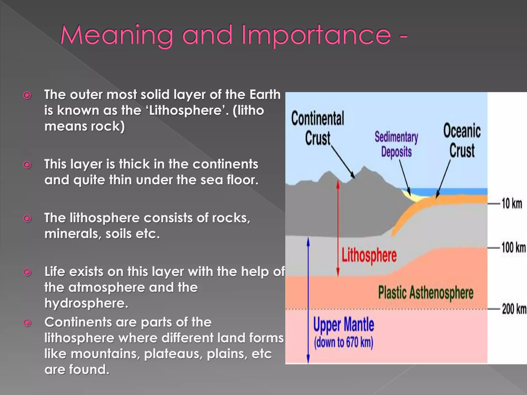
 The outer most solid layer of the Earth
is known as the ‘Lithosphere’. (litho
means rock)
 This layer is thick in the continents
and quite thin under the sea floor.
 The lithosphere consists of rocks,
minerals, soils etc.
 Life exists on this layer with the help of
the atmosphere and the
hydrosphere.
 Continents are parts of the
lithosphere where different land forms
like mountains, plateaus, plains, etc
are found.
 Our planet Earth is more than 4.6 billion years old and
still in the process of changing.
 Man is in quest of understanding this change and
eager to know more about inside the Earth.
 With years of study and research human beings have
been able to get information about the materials inside
the earth up to 10 to 12 km s.
 Going beyond this depth is very difficult due to the
increase of temperature. (1degree C every 32 meters)
 To understand more about the Earth’s interior humans are dependent on
indirect evidences such as seismic waves, volcanic materials etc.
 The Earth’s interior comprises of various materials in different forms.
 On the basis of density of material, chemical composition and physical
state of matter the Earth’s interior is classified in to 3 layers.
 They are - a) Crust
b) The Mantle
c) The Core
 The crust is the upper most layer of the Earth.
 This is made by the Silica, Aluminum and Magnesium.
 The depth of this layer is around 60 kms from the
surface.
 In the upper part of the crust only lighter materials are
found.
 It is called SIAL (silica and aluminum) or continental
crust.
 The lower part is called SIMA(silica and magnisium) or
oceanic crust.
 The Mantle is the second and the middle layer of the Earth.
 The depth of this layer is upto2900 kms from the surface.
 The materials are in semi liquid or partially molten state
which is called Magma.
 The mantle is composed of dense and rigid rocks which
have predominance of minerals like magnesium and iron.
 The mantle has two parts –
a) Upper mantle or the Astheno sphere. (molten)
b) Lower mantle or the Mesosphere. (solid)
 The contact zone of the Crust and the Mantle is called
‘Mohorovicic Discontinuity’ or ‘Moho’.
 While the boundary that separates the mantle from the
Core is called ‘Gutenberg Discontinuity’.
 Here the rocks are different in chemical composition
from those below and above.
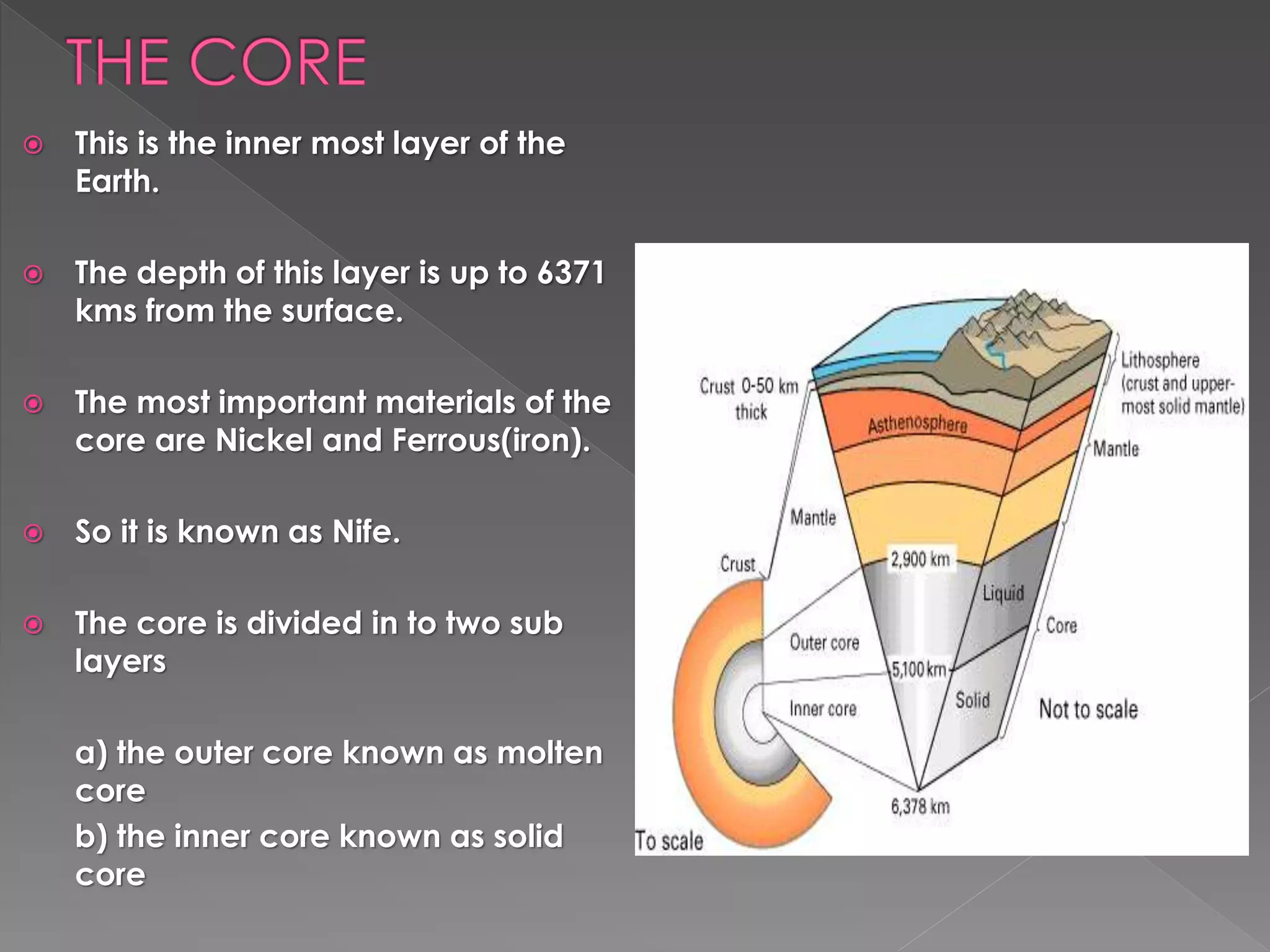
 This is the inner most layer of the
Earth.
 The depth of this layer is up to 6371
kms from the surface.
 The most important materials of the
core are Nickel and Ferrous(iron).
 So it is known as Nife.
 The core is divided in to two sub
layers
a) the outer core known as molten
core
b) the inner core known as solid
core
 Facts File – the deepest land mines
 The Akola peninsula of Russia is around 12 kms.
 The Kimberly diamond mine in South Africa is
around 3.9 kms.
 The Gold mine of KGF in India is around 1.5
kms.
 Rocks are the solid inorganic substances that are
found in the crust of the Earth.
 They are aggregate of minerals.
 Rocks are formed due to various natural process.
 On the basis of mode of formation rocks are classified
into three types – a) Igneous rocks .
b) Sedimentary rocks .
c) Metamorphic rocks .
 The word Igneous means ‘fire’.
 Derived from the Latin word
‘Ignis’ or Sanskrit word ‘Agni’.
 They formed by the cooling of
the molten matter of the Earth.
 Igneous rocks made first and
also called ‘Primary rocks’.
 Two types are –
a) Intrusive igneous rocks.
b) Extrusive igneous rocks
 The molten materials (magma) of
the earth’s interior cool and solidify
below the surface and called
intrusive igneous rocks.
 They made large crystals and are
found at depth.
 Ex – granite, diorite, gabbros.
 Extrusive rocks – made by
solidification of magma above the
earth’s surface.
 These rocks cools and solidifies
quickly.
 Ex – basalt and andesite.
 The word Sedimentary is derived
from a Latin word ‘Sedimentum’,
which means ‘setting down’.
 Sedimentary rocks are formed by
the agency of water , wind and ice.
 These agents break and erode the
igneous rocks, transport those
broken fragments and deposit
them at certain places.
 The deposit of these materials often
occurs in the form of layers or
strata.
 Therefore sedimentary rocks are
called stratified rocks.
 These rocks are also called
aqueous rocks because they are
formed in water bodies (Lake, Sea
and Ocean beds)
 Mechanically formed sedimentary rocks:
Rocks built up by fragments of pre-existing
rocks which have been produced by the
processes of weathering and erosion eg.,
Sandstone and Shale.
 Chemically formed sedimentary rocks:
Chemical sediments are commonly formed by
the process of evaporation of water containing
salts in solution eg., Rock salt, Gypsum etc.
 Organically formed sedimentary rocks:
Organic sediments are those derived by the
accumulation of remains of organisms, such as
shells of marine organisms, remains of plants
and animals eg., Limestone and coal.
Shale Sand Stone
Rock Salt Gypsum
Lime Stone
Coal
 Metamorphic rocks are those which are formed by the
process of metamorphism or alteration of pre-existing
rocks. Metamorphism means change of form which
may be physical or chemical or both the influence of
heat and pressure.
 Example:
a) Granite – Gneiss
b) Ballast – Schist
c) Lime Stone – Marble
d) Sandstone – Quartzite
e) Coal – Graphite
f) Graphite – Diamond
Metamorphic rocks are the hardest rocks on the earth. These rocks supply Precious
stones. Ex: Sapphire, Ruby and Emerald and Diamonds
 The Earth has two important forces that
change the face of the earth.
1. Internal Forces
These are the forces which originate inside
the crust and influence the surface features of
the earth eg., Volcanoes, Earthquakes etc.
The internal forces are also called Endogenic
forces.
A Volcano is a vent or narrow opening in the Earth’s
crust connected by a pipe of an underlying
magma, rock fragments, lava, ash, steam, flames
and other gases are emitted from the interior of the
Earth.
A passage in the earth’s crust through which magma
and other volcanic materials are ejected is called
‘Vent’.
The Funnel-shaped hollow at the top of the cone of a
volcano is called ‘Crater’. A large basin –shaped
crater bounded by steep sides is known as
‘Caldera’.
Structure of a volcano
 On the basis of the periodicity or frequency of eruption
volcanoes are classified into three types.
 1. Active Volcanoes : Volcanoes which constantly eject lava,
gases, ashes etc., are known as active volcanoes. There are
about 600 active volcanoes in the world. Eg. Mt. Stromboli
and Mt. Etna in Italy, St. Helens in USA, Mauna Loa in Hawaiian
islands, Pinatubo in Philippines etc.
Mt. Stromboli
Mt. Etna
 2. Dormant Volcanoes : Dormant Volcanoes are those
which have erupted in the past and are likely to erupt
again but have reminded inactive for fairly long
periods eg. Mt. Vesuvius in Italy, Mt. Fujiyama in
Japan, Mt. Kilimanjaro in Tanzania, Mt. Krakatoa in
Indonesia.
Mt. Fujiyama Mt. Kilimanjaro
3. Extinct Volcanoes : Extinct volcanoes are those
which were active in the remote geological periods.
These are not likely to be active once again eg.,
Gorongoro in Tanzania, Arthur’s Seat in Scottland.
Gorongoro Arthur’s Seat
 Super volcanic eruptions of the world
 Mt. Vesuvius (Italy)
 Mt. Karakatoa (Indonesia)
 Mt. Pelee (West Indies)
 Mt. Fujiyama or Fuji, a volcano worshiped
by people of Japan.
 Volcanic materials: The materials ejecting
out from the volcanoes are of three types.
 Solid: Volcanic bombs, Cinders, Scoria,
Pumice, Dust, Ash.
 Liquid: Lava
 Gases: Sulphur, Hydrogen, Carbon dioxide.
 Volcanoes occur in many regions of the world, including islands,
young mountain ranges and plateaus of the countries. Most
important regions are:
 1. The Circum – Pacific Belt or Pacific ring Of Fire : Costal margins of
the Pacific Ocean consisting of Philippines, Japan, USA, Central
America, South America etc.
2. Mid Atlantic Belt: Iceland and West Indies
3. Mid-Continental Belt: Italy, Spain, France,
Greece, Turkey etc.,
4. Important Islands: Hawaii, Indonesia
 Earthquake is a shock or series of shocks or tremors,
due to a sudden movement of crustal rocks generated
within the crust or mantle.
 The intensity of the earthquakes is maximum near the
epicentre and decreases with distances from the
epicentre. However the effects of an earthquake are
greater if the seismic focus lies near the surface of the
earth. The point on the earth’s surface vertically above
the seismic focus is called Epicentre.
 The Scientific study of earthquake is called Seismology.
The origin, time, velocity and direction of seismic
waves are recorded by an instrument known as
Seismograph.
 Plate Tectonics: The earth’s crust consists of many major and minor
plates. These plates are not stationery. The plate boundaries are
dynamic places and are the primary location of earthquake
activity (Circum- Pacific Belt).
 Volcanic Eruptions: Volcanic earthquakes are caused by gas
explosions (Krakatoa volcano of Indonesia).
 Faulting: A fault consists of a fracture in a rock along with a great
deal of displacement takes place. Earthquakes occur when
movement of plates takes place along a line of fracture (San
Andreas fault of California in USA).
 Man made factors: Over interaction of man with nature is also one
of the main causes of the occurrence of many of the earthquakes.
The extraction of minerals, deep underground mining, huge dams
and reservoirs, nuclear tests etc (Koyna dam in Maharastra,
Hoover dam in USA)
 The earthquake or seismic waves originate in the
seismic focus and travel towards the epicentre in
ripples or concentric circles. The three important
earthquake waves are:
 1. Primary Waves (PW): Primary waves are also known
as longitudinal or compressional waves. They can pass
through solid, liquid and gaseous matters.
 2. Secondary Waves (SW): Secondary waves are also
known as transverse or distortional waves. These waves
cannot pass through liquids. They reach the epicentre
after the primary waves.
 3. Surface Waves(LW): Surface waves are also called
long waves. They are slowest earthquake waves but
are responsible for the highest destruction on the
surface of the earth.
 The magnitude and intensity of earthquake
is recorded by using Richter Scale.
 The earthquakes are very dangerous and
destructive. They cause large-scale deaths,
loss to property, landslides, flash floods,
damages to bridges, roads, railway lines,
etc.
 Tsunami is a large sea wave occasionally
experienced along the costs of Japan and in other
regions caused by an underwater earthquake. In
Japanese language ‘Tsunami’ means ‘harbour
waves.
 1. On 26th December, 2004 a Tsunami in the
Indian Ocean swept the costal low lands of
Indonesia, India, Sri Lanka, Thailand etc.
 2. On 11th March, 2011 a Tsunami in the
Pacific Ocean caused huge damage in the
eastern coastal regions of Japan
(Fukushima, Sendai, Miyagi etc)
 3. Some seismic recording centres of India:
Gowribidanur, Kodaikanal, Pune,
Hyderabad, Dehradun.
1. The Circum-Pacific Belt – Regions around the Pacific Ocean
(New Zealand, Philippines, Japan, USA, Peru etc.,
2. The Mediterranean Belt – Regions around the Mediterranean
Sea,
3. The Himalayan Belt – The Siwalik region of India.
 The natural forces that modify the surface of the earth
 Imp are – temperature, wind, rainfall, snowfall, river,
glacier etc
 These forces act on the surface of the earth and
constantly changes its features
 WEATHERING:-
 It is wearing away or breaking down or gradual
disintegration of rocks by agents (temperature,
rainfall, wind etc) present in the atmosphere.
 Three types:-
 1. Mechanical weathering
 2. Chemical weathering
 3. Biological weathering
 1. Mechanical weathering:-
 When the rock is broken and disintegrated without any chemical
alteration , the process is called physical weathering or
mechanical weathering.
 Imp process of Mw are Granular disintegration, Block
disintegration and exfoliation
 Agents of Mw are temperature, wind, frost etc.
 2. Chemical weathering:-
 This is mainly brought by the action of
substances dissolved in rainwater.
 This type of weathering results in changing in
composition of minerals present in the rocks.
4 types.
 A) Oxidation- oxygen dissolved in water
reacts with certain minerals, especially iron
to form oxides
 B) Carbonation – when the rain water falls on
limestone rocks, the calcium carbonate
present in rocks absorbs carbon dioxide
from rain water and becomes calcium
bicarbonate
 C) Hydration- this is the process by which
some minerals in crystalline form absorb
water and become a powdery mass.
Feldspar is the common rock forming
crystalline mineral
 D) Solution- when the rain falls on the
surface of the land, rain water dissolves
solution minerals present in the rocks.
 3. Biological weathering:-
 Living organism like plants, animals and human beings play a role
in one way or another in weathering of rocks.
 This type includes both physical and chemical weathering
 a) Plants – growth and expansion of roots
 b) Animals – Burrowing animals, earthworms,
rabbits, rats.
 c) Human: beings – mining, quarrying, construction
works.
 Agents :- denudation is the action of changing landscape or
changing the surface of the earth by various natural agents
like rivers, glaciers, underground water, wind, sea waves etc.
 The work of these natural agents are Erosion, Transportation
and deposition
 These process produce distinct relief features
 River:- A mass of fresh water flowing from its source to mouth
along a definite course is called River.
 The river is a most prominent agent of denudation
 The place where the river takes birth is called source
 Mouth is the point where river meets sea or ocean
 Tributaries are the feeders or small streams which supply water
to river along its course
 The point where a tributary joins the main river is called
Confluence
 Course of the river:-
 The course of river from its source to the mouth is divided into three
stages – upper course, middle course and lower course.
 The Upper course:- vertical erosion is most common due to steep
slopes leading to deepening of valleys, resulting in the formation of
gorges, canyons, ‘V’ shaped valleys, waterfalls( Angel falls, Niagara
falls, Jog falls)
 The Middle Course:-
 In the middle course , the river path has a moderate slope and
velocity is less than that in the upper course.
 The volume of water increases when many tributaries join the main
river.
 The main work of the river in this stage is transportation of sediments
and little deposition.
 The imp landforms in this stage are Alluvial fans, Meanders
 The Lower Course:-
 In this stage the slopes of the river course is very minimum.
 The volume of river water is more and deposition is the main work of
the river. Imp landforms in this course – Floodplains, Natural levees,
Ox-bow lakes, Deltas( Sundarban, Nile delta)
 Fact file:-
 Estuary:- Tidal mouth of a river broadening
into the sea/ ocean.
 Delta :- A fan shaped, low lying area of
deposits at a river mouth.
 Slowly moving, compacted form of ice
and snow found in the high mountains and
polar regions.
 The mass of the ice or snow is pulled down
by its weight and due to the force of
gravity
 Types:-
 1. Continental glaciers :- these are
extensive ice sheets found in polar
regions. Eg; Greenland, Antarctica
 2. Mountain or Alpine or Valley Glaciers:-
glaciers found in the mountain regions.
 Glacier as an agent of denudation :-
performs the work of erosion ,
transportation and deposition.
 The erosional work of glacier is mainly side
cutting
 The landforms resulting by this are Cirque,
Horn, Arete, ‘U’ shaped valleys, Hanging
valleys, Rock steps etc.
 The transportation and the deposition work of glacier
goes almost together.
 The important depositional landforms produced by
glaciers are Moraines, Drumlins, Esker, Kames, Outwash
plains, Till plains etc.
 Moraines are the most important landforms of the
glaciated region. They are of 4 types
 a) Lateral Moraines:- Rock debris deposited along the
sides of the glacial valley
 b) Medial Moraines:- When two lateral moraines meet, it
forms medial moraines
 c) Ground Moraines :- Rock materials found on the floor
or at the bottom of the glacial valley
 d) Terminal Moraines:- The glacial deposits found at the
end of the glacier
 THE WORK OF THE GLACIER – GLACIAL CYCLE
 Underground water is the subsoil water found on account of percolation or
seepage of water into the ground.
 Underground water seeps into the ground passes through various layers of
rocks.
 The rocks which allow the water to percolate is called ‘pervious’ or ‘porous’
rocks and the rocks which do not allow the water inside are called
impervious or non-porous rocks.
 The porous rock beds which hold large amount of underground water are
called aquifers.
 The pervious rocks allows and hold water and form springs.
 A spring is a place where the underground water comes out naturally.
 1. Perennial spring: It is a spring
through which water comes out
continuously.
 2. Intermittent springs: These are
springs through which water
comes out intermittently (not
continuous) and they are also
called ‘Periodic spring’
 3. Hot Springs: Whenever warm or
hot water (like a fountain comes
out naturally it is called hot spring
or thermal spring. They are usually
found near the volcanic regions.
 4. Geyser: Geysers throw a jet of hot water (like a fountain)
and steam the air at regular or irregular intervals eg., Old
Faithful in Yellowstone National Park of USA.
 5. Artesian wells: When underground water is stored in a
basin shaped layer between two non-porous rocks, the
water cannot come out naturally. An artificial hole is made
to the porous rock, the water comes out like a fountain.
These wells are common in Australia.
 Underground water performs the work of erosion,
transportation and deposition.
 The work of underground water is predominant in
limestone region.
 The important landforms associated with the
underground water are Lapies, Sinkholes, Limestone
caves, Stalactites, stalagmites, Calcite pillar etc.
 Facts File: Limestone caves – 1. Akalagavi (Ulavi)
caves of Uttara Kannada in Karnataka 2. Belum and
Bohra caves of Andra Pradesh.
 Relief features formed by underground water in
limestone region is called ‘Karsttopography’
 The denudation work of wind is common in the arid or desert regions.
 When the winds of high velocity blow over desert areas they erode,
transport and deposit materials to produce different landforms.
 The important land forms associated with the erosional work of the
wind are Rock pedestals, Mushroom rock, Inselberg.
 The depositional landforms are Sand dunes – Longitudinal sand
dunes, Brachans and Loesses deposits.
 Barchans: are semi-circular or crescent shaped sand depsoits most
common in the deserts. Loess is the sand particles found beyond the
borders of deserts (Yellow soil in China). Work of wind is called
“Aeolian cycle”
 Like all other agents, sea waves are also an important exogenic
agent of denudation.
 Sea waves are the regular undulation of water on the sea or
ocean.
 The work of sea waves is significant along the seashore or coasts.
 The important land forms associtated with sea waves are cliff, sea
cave, sea stack, sea arch, headland, sand bars, beaches,
lagoons etc.

More Related Content

What's hot

class 7 inside our earth
class 7 inside our earthclass 7 inside our earth
class 7 inside our earth
Subhash Gaur
 

What's hot (20)

The gupta empire
The gupta empireThe gupta empire
The gupta empire
 
The interior of the earth
The interior of the earthThe interior of the earth
The interior of the earth
 
class 7 inside our earth
class 7 inside our earthclass 7 inside our earth
class 7 inside our earth
 
Inside our earth (grade VII, c-2)
Inside our earth (grade VII, c-2)Inside our earth (grade VII, c-2)
Inside our earth (grade VII, c-2)
 
Hydrosphere
Hydrosphere Hydrosphere
Hydrosphere
 
Structure of Earth and its Composition
Structure of Earth and its CompositionStructure of Earth and its Composition
Structure of Earth and its Composition
 
STRUCTURE AND COMPOSITION OF EARTH
STRUCTURE AND COMPOSITION OF EARTHSTRUCTURE AND COMPOSITION OF EARTH
STRUCTURE AND COMPOSITION OF EARTH
 
THE LITHOSPHERE
THE LITHOSPHERETHE LITHOSPHERE
THE LITHOSPHERE
 
structure and composition of lithosphere
structure and composition of lithospherestructure and composition of lithosphere
structure and composition of lithosphere
 
Origin of the Earth
Origin of the EarthOrigin of the Earth
Origin of the Earth
 
Earth's Structure
Earth's StructureEarth's Structure
Earth's Structure
 
metalic and non metalic mineralas
metalic and non metalic mineralasmetalic and non metalic mineralas
metalic and non metalic mineralas
 
EARTH'S LAYER
EARTH'S LAYEREARTH'S LAYER
EARTH'S LAYER
 
Rocks; types of rocks
Rocks; types of rocksRocks; types of rocks
Rocks; types of rocks
 
Sedimentary rocks
Sedimentary rocksSedimentary rocks
Sedimentary rocks
 
Interior of earth
Interior of earthInterior of earth
Interior of earth
 
Earths Structure
Earths StructureEarths Structure
Earths Structure
 
The Age of the Guptas
The Age of the GuptasThe Age of the Guptas
The Age of the Guptas
 
temporal and spatial distribution of coal in india
temporal and spatial distribution of coal in indiatemporal and spatial distribution of coal in india
temporal and spatial distribution of coal in india
 
Earth internal structure
Earth internal structureEarth internal structure
Earth internal structure
 

Viewers also liked

Forest Rights Act_Provisions: By Madhu Sarin
Forest Rights Act_Provisions: By Madhu SarinForest Rights Act_Provisions: By Madhu Sarin
Forest Rights Act_Provisions: By Madhu Sarin
bmbks321
 
Structure and Composition of the Atmosphere
Structure and Composition of the AtmosphereStructure and Composition of the Atmosphere
Structure and Composition of the Atmosphere
beaudry2011
 
STRUCTURE OF THE ATMOSPHERE
STRUCTURE OF THE ATMOSPHERESTRUCTURE OF THE ATMOSPHERE
STRUCTURE OF THE ATMOSPHERE
GeoCoops
 

Viewers also liked (20)

Helicases ppt.
Helicases ppt.Helicases ppt.
Helicases ppt.
 
Burial History
Burial HistoryBurial History
Burial History
 
air pollution
air pollutionair pollution
air pollution
 
Forest Rights Act_Provisions: By Madhu Sarin
Forest Rights Act_Provisions: By Madhu SarinForest Rights Act_Provisions: By Madhu Sarin
Forest Rights Act_Provisions: By Madhu Sarin
 
Forest rights act 2006
Forest rights act 2006Forest rights act 2006
Forest rights act 2006
 
Soils of India/ Karnataka State New syllabus/ Social Science/ Geography/ Chap...
Soils of India/ Karnataka State New syllabus/ Social Science/ Geography/ Chap...Soils of India/ Karnataka State New syllabus/ Social Science/ Geography/ Chap...
Soils of India/ Karnataka State New syllabus/ Social Science/ Geography/ Chap...
 
Forest rights act
Forest rights actForest rights act
Forest rights act
 
Physical Geography Lecture 11 - The Lithosphere 111416
Physical Geography Lecture 11 - The Lithosphere 111416Physical Geography Lecture 11 - The Lithosphere 111416
Physical Geography Lecture 11 - The Lithosphere 111416
 
Atmosphere, hydrosphere, and lithosphere (1)
Atmosphere, hydrosphere, and lithosphere (1)Atmosphere, hydrosphere, and lithosphere (1)
Atmosphere, hydrosphere, and lithosphere (1)
 
Indian forest act
Indian forest actIndian forest act
Indian forest act
 
Forest act 1927
Forest act 1927Forest act 1927
Forest act 1927
 
Subsidence
SubsidenceSubsidence
Subsidence
 
NATIONAL FOREST POLICY
NATIONAL FOREST POLICYNATIONAL FOREST POLICY
NATIONAL FOREST POLICY
 
Forest resources of india
Forest resources of indiaForest resources of india
Forest resources of india
 
INDIAN WILDLIFE PROTECTION ACT 1972
INDIAN WILDLIFE PROTECTION ACT 1972INDIAN WILDLIFE PROTECTION ACT 1972
INDIAN WILDLIFE PROTECTION ACT 1972
 
Structure and Composition of the Atmosphere
Structure and Composition of the AtmosphereStructure and Composition of the Atmosphere
Structure and Composition of the Atmosphere
 
Sedimentary Basins
Sedimentary BasinsSedimentary Basins
Sedimentary Basins
 
STRUCTURE OF THE ATMOSPHERE
STRUCTURE OF THE ATMOSPHERESTRUCTURE OF THE ATMOSPHERE
STRUCTURE OF THE ATMOSPHERE
 
Types of forest in India
Types of forest in IndiaTypes of forest in India
Types of forest in India
 
Forests of India
Forests of IndiaForests of India
Forests of India
 

Similar to Lithosphere VIII Social Science Karnataka State syllabus

3.Introduction to Geology and Geological Investigation.docx
3.Introduction to Geology and Geological Investigation.docx3.Introduction to Geology and Geological Investigation.docx
3.Introduction to Geology and Geological Investigation.docx
AzazAlamKhan
 
Internaldynamics4eso
Internaldynamics4esoInternaldynamics4eso
Internaldynamics4eso
martagar78
 
plate-tectonics-ppppppppppower-point.ppt
plate-tectonics-ppppppppppower-point.pptplate-tectonics-ppppppppppower-point.ppt
plate-tectonics-ppppppppppower-point.ppt
LiezelVillaruz
 
Igneous rock ge 106
Igneous rock ge 106Igneous rock ge 106
Igneous rock ge 106
Ahmed Hamza
 
Chapter 9 Science Ppt
Chapter 9 Science PptChapter 9 Science Ppt
Chapter 9 Science Ppt
P Cole
 

Similar to Lithosphere VIII Social Science Karnataka State syllabus (20)

std 8 lithosphere part 2.pptx
std 8 lithosphere part 2.pptxstd 8 lithosphere part 2.pptx
std 8 lithosphere part 2.pptx
 
LIthosphere
LIthosphereLIthosphere
LIthosphere
 
CBSE CLASS VII GEOGRAPHY
CBSE CLASS VII GEOGRAPHYCBSE CLASS VII GEOGRAPHY
CBSE CLASS VII GEOGRAPHY
 
natural science lithosphere.pptx
natural science lithosphere.pptxnatural science lithosphere.pptx
natural science lithosphere.pptx
 
3.Introduction to Geology and Geological Investigation.docx
3.Introduction to Geology and Geological Investigation.docx3.Introduction to Geology and Geological Investigation.docx
3.Introduction to Geology and Geological Investigation.docx
 
13. Earth Structure and Rock Cycle_2.pptx
13. Earth Structure and Rock Cycle_2.pptx13. Earth Structure and Rock Cycle_2.pptx
13. Earth Structure and Rock Cycle_2.pptx
 
layers of the earth
layers of the earth layers of the earth
layers of the earth
 
Internaldynamics4eso
Internaldynamics4esoInternaldynamics4eso
Internaldynamics4eso
 
in search of earth's seacrets
in search of earth's seacretsin search of earth's seacrets
in search of earth's seacrets
 
The earth’s interior
The earth’s interiorThe earth’s interior
The earth’s interior
 
Geology
GeologyGeology
Geology
 
plate-tectonics-ppppppppppower-point.ppt
plate-tectonics-ppppppppppower-point.pptplate-tectonics-ppppppppppower-point.ppt
plate-tectonics-ppppppppppower-point.ppt
 
Earthscience..
Earthscience..Earthscience..
Earthscience..
 
Earth's processes--Danielle Lewis
Earth's processes--Danielle LewisEarth's processes--Danielle Lewis
Earth's processes--Danielle Lewis
 
Igneous rock ge 106
Igneous rock ge 106Igneous rock ge 106
Igneous rock ge 106
 
Chapter 9 Science Ppt
Chapter 9 Science PptChapter 9 Science Ppt
Chapter 9 Science Ppt
 
Chapter 9 Science Ppt
Chapter 9 Science PptChapter 9 Science Ppt
Chapter 9 Science Ppt
 
Restless Earth 2 PowerPoint Presentation
Restless Earth 2 PowerPoint PresentationRestless Earth 2 PowerPoint Presentation
Restless Earth 2 PowerPoint Presentation
 
Earth's insides (teach)
Earth's insides (teach)Earth's insides (teach)
Earth's insides (teach)
 
Geological oceanography 301
Geological oceanography 301Geological oceanography 301
Geological oceanography 301
 

Recently uploaded

Use of Raffias’ species (Raphia spp.) and its impact on socioeconomic charact...
Use of Raffias’ species (Raphia spp.) and its impact on socioeconomic charact...Use of Raffias’ species (Raphia spp.) and its impact on socioeconomic charact...
Use of Raffias’ species (Raphia spp.) and its impact on socioeconomic charact...
Open Access Research Paper
 
一比一原版(Monash毕业证)莫纳什大学毕业证成绩单
一比一原版(Monash毕业证)莫纳什大学毕业证成绩单一比一原版(Monash毕业证)莫纳什大学毕业证成绩单
一比一原版(Monash毕业证)莫纳什大学毕业证成绩单
pcoow
 
一比一原版(Monash毕业证)莫纳什大学毕业证成绩单
一比一原版(Monash毕业证)莫纳什大学毕业证成绩单一比一原版(Monash毕业证)莫纳什大学毕业证成绩单
一比一原版(Monash毕业证)莫纳什大学毕业证成绩单
qogbuux
 
一比一原版EUR毕业证鹿特丹伊拉斯姆斯大学毕业证成绩单如何办理
一比一原版EUR毕业证鹿特丹伊拉斯姆斯大学毕业证成绩单如何办理一比一原版EUR毕业证鹿特丹伊拉斯姆斯大学毕业证成绩单如何办理
一比一原版EUR毕业证鹿特丹伊拉斯姆斯大学毕业证成绩单如何办理
exehay
 
一比一原版(Adelaide毕业证)阿德莱德大学毕业证成绩单
一比一原版(Adelaide毕业证)阿德莱德大学毕业证成绩单一比一原版(Adelaide毕业证)阿德莱德大学毕业证成绩单
一比一原版(Adelaide毕业证)阿德莱德大学毕业证成绩单
qogbuux
 
Prevalence, biochemical and hematological study of diabetic patients
Prevalence, biochemical and hematological study of diabetic patientsPrevalence, biochemical and hematological study of diabetic patients
Prevalence, biochemical and hematological study of diabetic patients
Open Access Research Paper
 
一比一原版(Lincoln毕业证)新西兰林肯大学毕业证成绩单
一比一原版(Lincoln毕业证)新西兰林肯大学毕业证成绩单一比一原版(Lincoln毕业证)新西兰林肯大学毕业证成绩单
一比一原版(Lincoln毕业证)新西兰林肯大学毕业证成绩单
tyvaq
 
Genetic diversity and association analysis for different morphological traits...
Genetic diversity and association analysis for different morphological traits...Genetic diversity and association analysis for different morphological traits...
Genetic diversity and association analysis for different morphological traits...
Open Access Research Paper
 
一比一原版(Massey毕业证)梅西大学毕业证成绩单
一比一原版(Massey毕业证)梅西大学毕业证成绩单一比一原版(Massey毕业证)梅西大学毕业证成绩单
一比一原版(Massey毕业证)梅西大学毕业证成绩单
tyvaq
 
A systematic review of the implementation of Industry 4.0 in human resources
A systematic review of the implementation of Industry 4.0 in human resourcesA systematic review of the implementation of Industry 4.0 in human resources
A systematic review of the implementation of Industry 4.0 in human resources
BOHR International Journal of Operations Management Research and Practices
 

Recently uploaded (20)

Major-Environmental-Problems and Proven Solutions.pdf
Major-Environmental-Problems and Proven Solutions.pdfMajor-Environmental-Problems and Proven Solutions.pdf
Major-Environmental-Problems and Proven Solutions.pdf
 
Use of Raffias’ species (Raphia spp.) and its impact on socioeconomic charact...
Use of Raffias’ species (Raphia spp.) and its impact on socioeconomic charact...Use of Raffias’ species (Raphia spp.) and its impact on socioeconomic charact...
Use of Raffias’ species (Raphia spp.) and its impact on socioeconomic charact...
 
Environmental Impact Assessment (EIA) in Nepal.pptx
Environmental Impact Assessment (EIA) in Nepal.pptxEnvironmental Impact Assessment (EIA) in Nepal.pptx
Environmental Impact Assessment (EIA) in Nepal.pptx
 
一比一原版(Monash毕业证)莫纳什大学毕业证成绩单
一比一原版(Monash毕业证)莫纳什大学毕业证成绩单一比一原版(Monash毕业证)莫纳什大学毕业证成绩单
一比一原版(Monash毕业证)莫纳什大学毕业证成绩单
 
一比一原版(Monash毕业证)莫纳什大学毕业证成绩单
一比一原版(Monash毕业证)莫纳什大学毕业证成绩单一比一原版(Monash毕业证)莫纳什大学毕业证成绩单
一比一原版(Monash毕业证)莫纳什大学毕业证成绩单
 
一比一原版EUR毕业证鹿特丹伊拉斯姆斯大学毕业证成绩单如何办理
一比一原版EUR毕业证鹿特丹伊拉斯姆斯大学毕业证成绩单如何办理一比一原版EUR毕业证鹿特丹伊拉斯姆斯大学毕业证成绩单如何办理
一比一原版EUR毕业证鹿特丹伊拉斯姆斯大学毕业证成绩单如何办理
 
DESERT ECOSYSTEM AND ITS CHARACTERISTICS AND TYPES
DESERT ECOSYSTEM AND ITS CHARACTERISTICS AND TYPESDESERT ECOSYSTEM AND ITS CHARACTERISTICS AND TYPES
DESERT ECOSYSTEM AND ITS CHARACTERISTICS AND TYPES
 
Natural farming @ Dr. Siddhartha S. Jena.pptx
Natural farming @ Dr. Siddhartha S. Jena.pptxNatural farming @ Dr. Siddhartha S. Jena.pptx
Natural farming @ Dr. Siddhartha S. Jena.pptx
 
一比一原版(Adelaide毕业证)阿德莱德大学毕业证成绩单
一比一原版(Adelaide毕业证)阿德莱德大学毕业证成绩单一比一原版(Adelaide毕业证)阿德莱德大学毕业证成绩单
一比一原版(Adelaide毕业证)阿德莱德大学毕业证成绩单
 
Prevalence, biochemical and hematological study of diabetic patients
Prevalence, biochemical and hematological study of diabetic patientsPrevalence, biochemical and hematological study of diabetic patients
Prevalence, biochemical and hematological study of diabetic patients
 
Powers and Functions of CPCB - The Water Act 1974.pdf
Powers and Functions of CPCB - The Water Act 1974.pdfPowers and Functions of CPCB - The Water Act 1974.pdf
Powers and Functions of CPCB - The Water Act 1974.pdf
 
Powers of State Pollution Control Board - The Water Act 1974
Powers of State Pollution Control Board - The Water Act 1974Powers of State Pollution Control Board - The Water Act 1974
Powers of State Pollution Control Board - The Water Act 1974
 
Paper: Man and Environmental relationship
Paper: Man and Environmental relationshipPaper: Man and Environmental relationship
Paper: Man and Environmental relationship
 
一比一原版(Lincoln毕业证)新西兰林肯大学毕业证成绩单
一比一原版(Lincoln毕业证)新西兰林肯大学毕业证成绩单一比一原版(Lincoln毕业证)新西兰林肯大学毕业证成绩单
一比一原版(Lincoln毕业证)新西兰林肯大学毕业证成绩单
 
Prevention and Control of Water Pollution
Prevention and Control of Water PollutionPrevention and Control of Water Pollution
Prevention and Control of Water Pollution
 
Genetic diversity and association analysis for different morphological traits...
Genetic diversity and association analysis for different morphological traits...Genetic diversity and association analysis for different morphological traits...
Genetic diversity and association analysis for different morphological traits...
 
一比一原版(Massey毕业证)梅西大学毕业证成绩单
一比一原版(Massey毕业证)梅西大学毕业证成绩单一比一原版(Massey毕业证)梅西大学毕业证成绩单
一比一原版(Massey毕业证)梅西大学毕业证成绩单
 
A systematic review of the implementation of Industry 4.0 in human resources
A systematic review of the implementation of Industry 4.0 in human resourcesA systematic review of the implementation of Industry 4.0 in human resources
A systematic review of the implementation of Industry 4.0 in human resources
 
DRAFT NRW Recreation Strategy - People and Nature thriving together
DRAFT NRW Recreation Strategy - People and Nature thriving togetherDRAFT NRW Recreation Strategy - People and Nature thriving together
DRAFT NRW Recreation Strategy - People and Nature thriving together
 
NRW Board Paper - DRAFT NRW Recreation Strategy
NRW Board Paper - DRAFT NRW Recreation StrategyNRW Board Paper - DRAFT NRW Recreation Strategy
NRW Board Paper - DRAFT NRW Recreation Strategy
 

Lithosphere VIII Social Science Karnataka State syllabus

  • 1.
  • 2.  The outer most solid layer of the Earth is known as the ‘Lithosphere’. (litho means rock)  This layer is thick in the continents and quite thin under the sea floor.  The lithosphere consists of rocks, minerals, soils etc.  Life exists on this layer with the help of the atmosphere and the hydrosphere.  Continents are parts of the lithosphere where different land forms like mountains, plateaus, plains, etc are found.
  • 3.  Our planet Earth is more than 4.6 billion years old and still in the process of changing.  Man is in quest of understanding this change and eager to know more about inside the Earth.  With years of study and research human beings have been able to get information about the materials inside the earth up to 10 to 12 km s.  Going beyond this depth is very difficult due to the increase of temperature. (1degree C every 32 meters)
  • 4.  To understand more about the Earth’s interior humans are dependent on indirect evidences such as seismic waves, volcanic materials etc.  The Earth’s interior comprises of various materials in different forms.  On the basis of density of material, chemical composition and physical state of matter the Earth’s interior is classified in to 3 layers.  They are - a) Crust b) The Mantle c) The Core
  • 5.  The crust is the upper most layer of the Earth.  This is made by the Silica, Aluminum and Magnesium.  The depth of this layer is around 60 kms from the surface.  In the upper part of the crust only lighter materials are found.  It is called SIAL (silica and aluminum) or continental crust.  The lower part is called SIMA(silica and magnisium) or oceanic crust.
  • 6.  The Mantle is the second and the middle layer of the Earth.  The depth of this layer is upto2900 kms from the surface.  The materials are in semi liquid or partially molten state which is called Magma.  The mantle is composed of dense and rigid rocks which have predominance of minerals like magnesium and iron.  The mantle has two parts –
  • 7. a) Upper mantle or the Astheno sphere. (molten) b) Lower mantle or the Mesosphere. (solid)  The contact zone of the Crust and the Mantle is called ‘Mohorovicic Discontinuity’ or ‘Moho’.  While the boundary that separates the mantle from the Core is called ‘Gutenberg Discontinuity’.  Here the rocks are different in chemical composition from those below and above.
  • 8.  This is the inner most layer of the Earth.  The depth of this layer is up to 6371 kms from the surface.  The most important materials of the core are Nickel and Ferrous(iron).  So it is known as Nife.  The core is divided in to two sub layers a) the outer core known as molten core b) the inner core known as solid core
  • 9.  Facts File – the deepest land mines  The Akola peninsula of Russia is around 12 kms.  The Kimberly diamond mine in South Africa is around 3.9 kms.  The Gold mine of KGF in India is around 1.5 kms.
  • 10.  Rocks are the solid inorganic substances that are found in the crust of the Earth.  They are aggregate of minerals.  Rocks are formed due to various natural process.  On the basis of mode of formation rocks are classified into three types – a) Igneous rocks . b) Sedimentary rocks . c) Metamorphic rocks .
  • 11.  The word Igneous means ‘fire’.  Derived from the Latin word ‘Ignis’ or Sanskrit word ‘Agni’.  They formed by the cooling of the molten matter of the Earth.  Igneous rocks made first and also called ‘Primary rocks’.  Two types are – a) Intrusive igneous rocks. b) Extrusive igneous rocks
  • 12.  The molten materials (magma) of the earth’s interior cool and solidify below the surface and called intrusive igneous rocks.  They made large crystals and are found at depth.  Ex – granite, diorite, gabbros.  Extrusive rocks – made by solidification of magma above the earth’s surface.  These rocks cools and solidifies quickly.  Ex – basalt and andesite.
  • 13.  The word Sedimentary is derived from a Latin word ‘Sedimentum’, which means ‘setting down’.  Sedimentary rocks are formed by the agency of water , wind and ice.  These agents break and erode the igneous rocks, transport those broken fragments and deposit them at certain places.  The deposit of these materials often occurs in the form of layers or strata.  Therefore sedimentary rocks are called stratified rocks.  These rocks are also called aqueous rocks because they are formed in water bodies (Lake, Sea and Ocean beds)
  • 14.  Mechanically formed sedimentary rocks: Rocks built up by fragments of pre-existing rocks which have been produced by the processes of weathering and erosion eg., Sandstone and Shale.  Chemically formed sedimentary rocks: Chemical sediments are commonly formed by the process of evaporation of water containing salts in solution eg., Rock salt, Gypsum etc.  Organically formed sedimentary rocks: Organic sediments are those derived by the accumulation of remains of organisms, such as shells of marine organisms, remains of plants and animals eg., Limestone and coal.
  • 15. Shale Sand Stone Rock Salt Gypsum
  • 17.  Metamorphic rocks are those which are formed by the process of metamorphism or alteration of pre-existing rocks. Metamorphism means change of form which may be physical or chemical or both the influence of heat and pressure.  Example: a) Granite – Gneiss b) Ballast – Schist c) Lime Stone – Marble d) Sandstone – Quartzite e) Coal – Graphite f) Graphite – Diamond Metamorphic rocks are the hardest rocks on the earth. These rocks supply Precious stones. Ex: Sapphire, Ruby and Emerald and Diamonds
  • 18.
  • 19.
  • 20.
  • 21.
  • 22.
  • 23.  The Earth has two important forces that change the face of the earth. 1. Internal Forces These are the forces which originate inside the crust and influence the surface features of the earth eg., Volcanoes, Earthquakes etc. The internal forces are also called Endogenic forces.
  • 24. A Volcano is a vent or narrow opening in the Earth’s crust connected by a pipe of an underlying magma, rock fragments, lava, ash, steam, flames and other gases are emitted from the interior of the Earth. A passage in the earth’s crust through which magma and other volcanic materials are ejected is called ‘Vent’. The Funnel-shaped hollow at the top of the cone of a volcano is called ‘Crater’. A large basin –shaped crater bounded by steep sides is known as ‘Caldera’.
  • 25. Structure of a volcano
  • 26.
  • 27.  On the basis of the periodicity or frequency of eruption volcanoes are classified into three types.  1. Active Volcanoes : Volcanoes which constantly eject lava, gases, ashes etc., are known as active volcanoes. There are about 600 active volcanoes in the world. Eg. Mt. Stromboli and Mt. Etna in Italy, St. Helens in USA, Mauna Loa in Hawaiian islands, Pinatubo in Philippines etc. Mt. Stromboli Mt. Etna
  • 28.  2. Dormant Volcanoes : Dormant Volcanoes are those which have erupted in the past and are likely to erupt again but have reminded inactive for fairly long periods eg. Mt. Vesuvius in Italy, Mt. Fujiyama in Japan, Mt. Kilimanjaro in Tanzania, Mt. Krakatoa in Indonesia. Mt. Fujiyama Mt. Kilimanjaro
  • 29. 3. Extinct Volcanoes : Extinct volcanoes are those which were active in the remote geological periods. These are not likely to be active once again eg., Gorongoro in Tanzania, Arthur’s Seat in Scottland. Gorongoro Arthur’s Seat
  • 30.  Super volcanic eruptions of the world  Mt. Vesuvius (Italy)  Mt. Karakatoa (Indonesia)  Mt. Pelee (West Indies)  Mt. Fujiyama or Fuji, a volcano worshiped by people of Japan.
  • 31.  Volcanic materials: The materials ejecting out from the volcanoes are of three types.  Solid: Volcanic bombs, Cinders, Scoria, Pumice, Dust, Ash.  Liquid: Lava  Gases: Sulphur, Hydrogen, Carbon dioxide.
  • 32.  Volcanoes occur in many regions of the world, including islands, young mountain ranges and plateaus of the countries. Most important regions are:  1. The Circum – Pacific Belt or Pacific ring Of Fire : Costal margins of the Pacific Ocean consisting of Philippines, Japan, USA, Central America, South America etc.
  • 33. 2. Mid Atlantic Belt: Iceland and West Indies
  • 34. 3. Mid-Continental Belt: Italy, Spain, France, Greece, Turkey etc., 4. Important Islands: Hawaii, Indonesia
  • 35.  Earthquake is a shock or series of shocks or tremors, due to a sudden movement of crustal rocks generated within the crust or mantle.  The intensity of the earthquakes is maximum near the epicentre and decreases with distances from the epicentre. However the effects of an earthquake are greater if the seismic focus lies near the surface of the earth. The point on the earth’s surface vertically above the seismic focus is called Epicentre.  The Scientific study of earthquake is called Seismology. The origin, time, velocity and direction of seismic waves are recorded by an instrument known as Seismograph.
  • 36.
  • 37.  Plate Tectonics: The earth’s crust consists of many major and minor plates. These plates are not stationery. The plate boundaries are dynamic places and are the primary location of earthquake activity (Circum- Pacific Belt).  Volcanic Eruptions: Volcanic earthquakes are caused by gas explosions (Krakatoa volcano of Indonesia).  Faulting: A fault consists of a fracture in a rock along with a great deal of displacement takes place. Earthquakes occur when movement of plates takes place along a line of fracture (San Andreas fault of California in USA).  Man made factors: Over interaction of man with nature is also one of the main causes of the occurrence of many of the earthquakes. The extraction of minerals, deep underground mining, huge dams and reservoirs, nuclear tests etc (Koyna dam in Maharastra, Hoover dam in USA)
  • 38.  The earthquake or seismic waves originate in the seismic focus and travel towards the epicentre in ripples or concentric circles. The three important earthquake waves are:  1. Primary Waves (PW): Primary waves are also known as longitudinal or compressional waves. They can pass through solid, liquid and gaseous matters.  2. Secondary Waves (SW): Secondary waves are also known as transverse or distortional waves. These waves cannot pass through liquids. They reach the epicentre after the primary waves.  3. Surface Waves(LW): Surface waves are also called long waves. They are slowest earthquake waves but are responsible for the highest destruction on the surface of the earth.
  • 39.  The magnitude and intensity of earthquake is recorded by using Richter Scale.  The earthquakes are very dangerous and destructive. They cause large-scale deaths, loss to property, landslides, flash floods, damages to bridges, roads, railway lines, etc.
  • 40.  Tsunami is a large sea wave occasionally experienced along the costs of Japan and in other regions caused by an underwater earthquake. In Japanese language ‘Tsunami’ means ‘harbour waves.
  • 41.  1. On 26th December, 2004 a Tsunami in the Indian Ocean swept the costal low lands of Indonesia, India, Sri Lanka, Thailand etc.  2. On 11th March, 2011 a Tsunami in the Pacific Ocean caused huge damage in the eastern coastal regions of Japan (Fukushima, Sendai, Miyagi etc)  3. Some seismic recording centres of India: Gowribidanur, Kodaikanal, Pune, Hyderabad, Dehradun.
  • 42. 1. The Circum-Pacific Belt – Regions around the Pacific Ocean (New Zealand, Philippines, Japan, USA, Peru etc., 2. The Mediterranean Belt – Regions around the Mediterranean Sea, 3. The Himalayan Belt – The Siwalik region of India.
  • 43.  The natural forces that modify the surface of the earth  Imp are – temperature, wind, rainfall, snowfall, river, glacier etc  These forces act on the surface of the earth and constantly changes its features  WEATHERING:-  It is wearing away or breaking down or gradual disintegration of rocks by agents (temperature, rainfall, wind etc) present in the atmosphere.  Three types:-  1. Mechanical weathering  2. Chemical weathering  3. Biological weathering
  • 44.  1. Mechanical weathering:-  When the rock is broken and disintegrated without any chemical alteration , the process is called physical weathering or mechanical weathering.  Imp process of Mw are Granular disintegration, Block disintegration and exfoliation  Agents of Mw are temperature, wind, frost etc.
  • 45.  2. Chemical weathering:-  This is mainly brought by the action of substances dissolved in rainwater.  This type of weathering results in changing in composition of minerals present in the rocks. 4 types.  A) Oxidation- oxygen dissolved in water reacts with certain minerals, especially iron to form oxides  B) Carbonation – when the rain water falls on limestone rocks, the calcium carbonate present in rocks absorbs carbon dioxide from rain water and becomes calcium bicarbonate  C) Hydration- this is the process by which some minerals in crystalline form absorb water and become a powdery mass. Feldspar is the common rock forming crystalline mineral  D) Solution- when the rain falls on the surface of the land, rain water dissolves solution minerals present in the rocks.
  • 46.  3. Biological weathering:-  Living organism like plants, animals and human beings play a role in one way or another in weathering of rocks.  This type includes both physical and chemical weathering  a) Plants – growth and expansion of roots
  • 47.  b) Animals – Burrowing animals, earthworms, rabbits, rats.
  • 48.  c) Human: beings – mining, quarrying, construction works.
  • 49.  Agents :- denudation is the action of changing landscape or changing the surface of the earth by various natural agents like rivers, glaciers, underground water, wind, sea waves etc.  The work of these natural agents are Erosion, Transportation and deposition  These process produce distinct relief features  River:- A mass of fresh water flowing from its source to mouth along a definite course is called River.  The river is a most prominent agent of denudation  The place where the river takes birth is called source  Mouth is the point where river meets sea or ocean  Tributaries are the feeders or small streams which supply water to river along its course  The point where a tributary joins the main river is called Confluence
  • 50.  Course of the river:-  The course of river from its source to the mouth is divided into three stages – upper course, middle course and lower course.  The Upper course:- vertical erosion is most common due to steep slopes leading to deepening of valleys, resulting in the formation of gorges, canyons, ‘V’ shaped valleys, waterfalls( Angel falls, Niagara falls, Jog falls)  The Middle Course:-  In the middle course , the river path has a moderate slope and velocity is less than that in the upper course.  The volume of water increases when many tributaries join the main river.  The main work of the river in this stage is transportation of sediments and little deposition.  The imp landforms in this stage are Alluvial fans, Meanders  The Lower Course:-  In this stage the slopes of the river course is very minimum.  The volume of river water is more and deposition is the main work of the river. Imp landforms in this course – Floodplains, Natural levees, Ox-bow lakes, Deltas( Sundarban, Nile delta)
  • 51.
  • 52.
  • 53.  Fact file:-  Estuary:- Tidal mouth of a river broadening into the sea/ ocean.  Delta :- A fan shaped, low lying area of deposits at a river mouth.
  • 54.  Slowly moving, compacted form of ice and snow found in the high mountains and polar regions.  The mass of the ice or snow is pulled down by its weight and due to the force of gravity  Types:-  1. Continental glaciers :- these are extensive ice sheets found in polar regions. Eg; Greenland, Antarctica  2. Mountain or Alpine or Valley Glaciers:- glaciers found in the mountain regions.  Glacier as an agent of denudation :- performs the work of erosion , transportation and deposition.  The erosional work of glacier is mainly side cutting  The landforms resulting by this are Cirque, Horn, Arete, ‘U’ shaped valleys, Hanging valleys, Rock steps etc.
  • 55.  The transportation and the deposition work of glacier goes almost together.  The important depositional landforms produced by glaciers are Moraines, Drumlins, Esker, Kames, Outwash plains, Till plains etc.  Moraines are the most important landforms of the glaciated region. They are of 4 types  a) Lateral Moraines:- Rock debris deposited along the sides of the glacial valley  b) Medial Moraines:- When two lateral moraines meet, it forms medial moraines  c) Ground Moraines :- Rock materials found on the floor or at the bottom of the glacial valley  d) Terminal Moraines:- The glacial deposits found at the end of the glacier  THE WORK OF THE GLACIER – GLACIAL CYCLE
  • 56.  Underground water is the subsoil water found on account of percolation or seepage of water into the ground.  Underground water seeps into the ground passes through various layers of rocks.  The rocks which allow the water to percolate is called ‘pervious’ or ‘porous’ rocks and the rocks which do not allow the water inside are called impervious or non-porous rocks.  The porous rock beds which hold large amount of underground water are called aquifers.  The pervious rocks allows and hold water and form springs.  A spring is a place where the underground water comes out naturally.
  • 57.  1. Perennial spring: It is a spring through which water comes out continuously.  2. Intermittent springs: These are springs through which water comes out intermittently (not continuous) and they are also called ‘Periodic spring’  3. Hot Springs: Whenever warm or hot water (like a fountain comes out naturally it is called hot spring or thermal spring. They are usually found near the volcanic regions.
  • 58.  4. Geyser: Geysers throw a jet of hot water (like a fountain) and steam the air at regular or irregular intervals eg., Old Faithful in Yellowstone National Park of USA.  5. Artesian wells: When underground water is stored in a basin shaped layer between two non-porous rocks, the water cannot come out naturally. An artificial hole is made to the porous rock, the water comes out like a fountain. These wells are common in Australia.
  • 59.  Underground water performs the work of erosion, transportation and deposition.  The work of underground water is predominant in limestone region.  The important landforms associated with the underground water are Lapies, Sinkholes, Limestone caves, Stalactites, stalagmites, Calcite pillar etc.  Facts File: Limestone caves – 1. Akalagavi (Ulavi) caves of Uttara Kannada in Karnataka 2. Belum and Bohra caves of Andra Pradesh.  Relief features formed by underground water in limestone region is called ‘Karsttopography’
  • 60.  The denudation work of wind is common in the arid or desert regions.  When the winds of high velocity blow over desert areas they erode, transport and deposit materials to produce different landforms.  The important land forms associated with the erosional work of the wind are Rock pedestals, Mushroom rock, Inselberg.  The depositional landforms are Sand dunes – Longitudinal sand dunes, Brachans and Loesses deposits.  Barchans: are semi-circular or crescent shaped sand depsoits most common in the deserts. Loess is the sand particles found beyond the borders of deserts (Yellow soil in China). Work of wind is called “Aeolian cycle”
  • 61.  Like all other agents, sea waves are also an important exogenic agent of denudation.  Sea waves are the regular undulation of water on the sea or ocean.  The work of sea waves is significant along the seashore or coasts.  The important land forms associtated with sea waves are cliff, sea cave, sea stack, sea arch, headland, sand bars, beaches, lagoons etc.