Download to read offline
![Analyzing the indicators Walk ability of cities, in order to improving urban vitality
| IJMER | ISSN: 2249–6645 | www.ijmer.com | Vol. 4 | Iss.10| Oct. 2014 | 68|
VIII. Conclusion
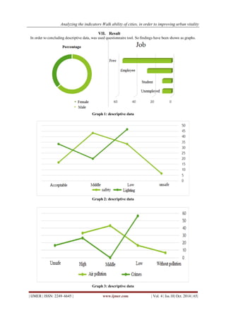
Sustainable transportation is a prerequisite for urban sustainable development .According to international organizations, the promotion of urban life quality could be obtained through a transportation that is compatible with economy, society, and environment aspects. Creating walkable neighborhoods is one of the strategies to achieve urban sustainability .This component not only accounts for a sustainable development pattern, but also pays attention to other development patterns such as public transportation-based development patterns as well as smart growth. In studying was studied side walk of KALANTARI highway condition. There is three hypotheses. They are:
- It seems, there isn’t vitality in this sidewalk.
- It seems, mentioned location isn’t safe position (light).
- It seems, citizen don’t satisfaction from position.
According to analyzed data, there isn’t vitality in this location. Also, citizen doesn't satisfy condition. So studied area need planning such as walkability in order to improving qualify. REFERENCES
[1]. Aultman-Hall, L., Roorda, M., &Baetz, B. (1997). Using GIS for evaluation of neighborhood pedestrian activity. J. Urban Plan. Dev.
[2]. Berrigan, D.,Troiano, P. (2002). The association between urban form and physical activity in U.S. adults. Am. J. Prev. Med., 23 (2S).
[3]. Crane, R. (2000). The influence of urban form on travel: an interpretive review. J. Plan. Lit., 15(1).
[4]. Ebrahimpour. Maryam (2014) Social safety's women in urban public space (Case study: Mashhad metropolitan), American Journal of Engineering Research, Volume-03, Issue-08
[5]. Greenwald, Michael J., Boarnet, & Marlon G. (2001). The built environment as a determinant of walking behavior: analyzing non-work pedestrian travel in Portland, Oregon. Transportation Res. Rec., 1780, 33–43.
[6]. Habibi, M. (1999).Walkways for Tourism.HonarhayeZiba, 9, 43-51.
[7]. Hutabarat-Lo, R. (2009). Walkability: What is it? Journal of Urbanism, 2(2), 145-166.
[8]. Hoehner, C. M., Brennan Ramirez, L. K., Elliott, M. B., Handy, S. L., &Brownson, R. C. (2004).Perceived and objective environmental measures and physical activity among urban adults.American Journal of Preventive Medicine, 28 (2S2), 2-15.
[9]. Newman, P., &Ken worthy, J. (2006). Urban design to reduce automobile dependence. polis, 2(1), 35-52.
[10]. Owen, N., Humpel, N., Leslie, E., Bauman, A., &Sallis, J. F. (2004). Understanding environmental influences on walking.American Journal of Preventive Medicine, 27(1), 67-76.
[11]. Shay, E., Spoon, S. C., &Khattak, A. J. (2004).Walkable environment and walkinactivity.US, Chapel Hill: University of North Carolina.
[12]. Shriver, K. (1997). Influence of environmental design on pedestrian travel behavior in four Austin neighbourhoods.Transportation Research Record,1578, 64-75.
[13]. South worth, M., & Ben-juseph, E. (2004).Reconsidering the Cul-de-sac. Access, 24, 28-33.
[14]. Southworth, A. F. (2008). Guest Editorial: Cities afoot-pedestrians, walkabilityand urban design. Journal of Urban Design, 13(1), 1-3.
[15]. Southworth, M. (2005).Designing the walkable city.Journal of Urban Planning and Development, 131, 246-257.
[16]. Vernez-Moudon, A., & Lee, C. (2003). Walking and bicycling: an evaluation of environmental audit instruments. Am. J. Health Promot., 18(1).](https://image.slidesharecdn.com/j0401002-6168-141108054412-conversion-gate02/85/Analyzing-the-indicators-walkability-of-cities-in-order-to-improving-urban-vitality-8-320.jpg)

1) The document examines the walkability of an urban highway in Mashhad, Iran in order to improve urban vitality. 2) A survey was conducted and SWOT analysis was used to analyze the results. The SWOT revealed strengths like a dedicated path for pedestrians but also weaknesses like a narrow sidewalk, inadequate lighting, and an unsafe underground space. 3) Recommendations are proposed to address problems like air and noise pollution and improve the urban space quality, identity and vitality along the highway.


