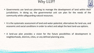
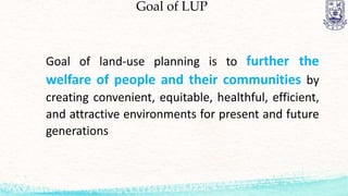
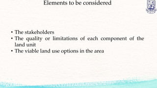
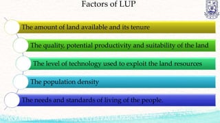
Land-Use Planning
GMP-121
IFFAT ARA
Lecturer
Dept. of Geomatics
LMA, PSTU
Class Outline
 Land-Use Planning
 Definition
 Elements to be considered during planning
 Issues to be resolved
 An integrated approach to land use planning
Physical Planning
Physical planning is the designing of the optimal physical
infrastructure of an administrative land unit, such as transport
facilities - roads, railways, airports, harbors; industrial plants and
storage of produce; mining and power generation, and facilities for
towns and other human settlements - in anticipation of population
increase and socio-economic development, and taking into account
the outcome of land use zoning and planning. It has both rural and
urban development aspects, though the latter usually predominates.
Land-Use Planning
• Land-use (or Land Resources) Planning is a systematic procedure carried out in order to
create an enabling environment for sustainable development of land resources which
meets people's needs and demands. It assesses the physical, socio-economic, institutional
and legal potentials and constraints with respect to an optimal and sustainable use of land
resources, and empowers people to make decisions about how to allocate those resources.
• (FAO, 1993) : Land-use planning is the systematic assessment of land and water potential,
alternatives for land use and economic and social conditions in order to select and adopt
the best land-use options. Its purposes to select and put into practice those land uses that
will best meet the needs of the people while safeguarding resources for the future. The
driving force in planning is the need for change, the need for improved management or the
need for a quite different pattern of land use dictated by changing circumstances.
Land-Use Planning
• Land-use planning is the general term used for a branch of urban
planning encompassing various disciplines which seek to order and
regulate land use in an efficient and ethical way, thus preventing land-
use conflicts.
• The Canadian Institute of Planners offers a definition that land-use
planning means the scientific, aesthetic, and orderly disposition of land,
resources, facilities and services with a view to securing the physical,
economic and social efficiency, health and well-being of urban and rural
communities.
Land-Use Planning
Land-use planning often leads to land-use regulation, which
typically encompasses zoning. Zoning regulates the types of
activities that can be accommodated on a given piece of land, as
well as the amount of space devoted to those activities, and the
ways that buildings may be situated and shaped.
Bhutanese Definition of Land-Use Planning
Means of supporting farmers and rural communities who make
their living from utilization of natural resources, so that their
standard of living increases sustainably, i.e. without creating
conflicts between the different types of land uses and land users
and without diminishing the resource base in the future.
Source:LUP News, Ministry of Agriculture, Thimphu, April
1993,Vol. 1, No. 1.
Why LUP?
• Governments use land-use planning to manage the development of land within their
jurisdictions. In doing so, the governmental unit can plan for the needs of the
community while safeguarding natural resources.
• It is the systematic assessment of land and water potential, alternatives for land use, and
economic and social conditions in order to select and adopt the best land-use options.
• A land-use plan provides a vision for the future possibilities of development in
neighborhoods, districts, cities, or any defined planning area.
Goal of LUP
Goal of land-use planning is to further the
welfare of people and their communities by
creating convenient, equitable, healthful, efficient,
and attractive environments for present and future
generations
Elements to be considered
• The stakeholders
• The quality or limitations of each component of the
land unit
• The viable land use options in the area
Factors of LUP
The amount of land available and its tenure
The quality, potential productivity and suitability of the land
The level of technology used to exploit the land resources
The population density
The needs and standards of living of the people.
Land Tenure
Land tenures a way of regulating rights, access and
control of land for the mutual benefit of the land user
and the government.
Land Tenure Forms
Land Tenure Forms
Stakeholder
A stakeholder is anyone or any institution who has interests in, or is
affected by, an issue or activity or transaction, and therefore has a
natural right to participate in decisions relating to it.
Characteristics:
• Those having, needing or seeking control of or access to a
resource.
• Those who are affected by the use of resources by others.
• Those wishing to influence the decisions of others on the use of
resources, for scientific, ethical or conservationist reasons
Stakeholder Types
• Direct stakeholders: who use the land targeted in the plan.
• Indirect stakeholders: who are affected by the actions of the
land users
• Interest groups: concerned with conservation or scientific use
of land.
Stakeholder Types
• Regional intergovernmental cooperation entities
• National or federal governments
• State or provincial governments,
• Non-governmental organizations (NGOs),
• Individual title deed or concession holders
• Long-existing rural communities
• Landless people and autonomous groups of migrants
• Urban communities in the area, or tourists,
• Any original inhabitants of the region
QUALITIES AND LIMITATIONS OF LAND
FOR DIFFERENT USES
QUALITIES AND LIMITATIONS OF LAND
FOR DIFFERENT USES
Land Qualities in the Agricultural Sphere
Data Requirements
on Land Resources
for Land Evaluation
Thank
You !

Introduction to Landuse planning

  • 1.
  • 2.
    Class Outline  Land-UsePlanning  Definition  Elements to be considered during planning  Issues to be resolved  An integrated approach to land use planning
  • 3.
    Physical Planning Physical planningis the designing of the optimal physical infrastructure of an administrative land unit, such as transport facilities - roads, railways, airports, harbors; industrial plants and storage of produce; mining and power generation, and facilities for towns and other human settlements - in anticipation of population increase and socio-economic development, and taking into account the outcome of land use zoning and planning. It has both rural and urban development aspects, though the latter usually predominates.
  • 4.
    Land-Use Planning • Land-use(or Land Resources) Planning is a systematic procedure carried out in order to create an enabling environment for sustainable development of land resources which meets people's needs and demands. It assesses the physical, socio-economic, institutional and legal potentials and constraints with respect to an optimal and sustainable use of land resources, and empowers people to make decisions about how to allocate those resources. • (FAO, 1993) : Land-use planning is the systematic assessment of land and water potential, alternatives for land use and economic and social conditions in order to select and adopt the best land-use options. Its purposes to select and put into practice those land uses that will best meet the needs of the people while safeguarding resources for the future. The driving force in planning is the need for change, the need for improved management or the need for a quite different pattern of land use dictated by changing circumstances.
  • 5.
    Land-Use Planning • Land-useplanning is the general term used for a branch of urban planning encompassing various disciplines which seek to order and regulate land use in an efficient and ethical way, thus preventing land- use conflicts. • The Canadian Institute of Planners offers a definition that land-use planning means the scientific, aesthetic, and orderly disposition of land, resources, facilities and services with a view to securing the physical, economic and social efficiency, health and well-being of urban and rural communities.
  • 6.
    Land-Use Planning Land-use planningoften leads to land-use regulation, which typically encompasses zoning. Zoning regulates the types of activities that can be accommodated on a given piece of land, as well as the amount of space devoted to those activities, and the ways that buildings may be situated and shaped.
  • 7.
    Bhutanese Definition ofLand-Use Planning Means of supporting farmers and rural communities who make their living from utilization of natural resources, so that their standard of living increases sustainably, i.e. without creating conflicts between the different types of land uses and land users and without diminishing the resource base in the future. Source:LUP News, Ministry of Agriculture, Thimphu, April 1993,Vol. 1, No. 1.
  • 8.
    Why LUP? • Governmentsuse land-use planning to manage the development of land within their jurisdictions. In doing so, the governmental unit can plan for the needs of the community while safeguarding natural resources. • It is the systematic assessment of land and water potential, alternatives for land use, and economic and social conditions in order to select and adopt the best land-use options. • A land-use plan provides a vision for the future possibilities of development in neighborhoods, districts, cities, or any defined planning area.
  • 9.
    Goal of LUP Goalof land-use planning is to further the welfare of people and their communities by creating convenient, equitable, healthful, efficient, and attractive environments for present and future generations
  • 10.
    Elements to beconsidered • The stakeholders • The quality or limitations of each component of the land unit • The viable land use options in the area
  • 11.
    Factors of LUP Theamount of land available and its tenure The quality, potential productivity and suitability of the land The level of technology used to exploit the land resources The population density The needs and standards of living of the people.
  • 12.
    Land Tenure Land tenuresa way of regulating rights, access and control of land for the mutual benefit of the land user and the government.
  • 13.
  • 14.
  • 15.
    Stakeholder A stakeholder isanyone or any institution who has interests in, or is affected by, an issue or activity or transaction, and therefore has a natural right to participate in decisions relating to it. Characteristics: • Those having, needing or seeking control of or access to a resource. • Those who are affected by the use of resources by others. • Those wishing to influence the decisions of others on the use of resources, for scientific, ethical or conservationist reasons
  • 16.
    Stakeholder Types • Directstakeholders: who use the land targeted in the plan. • Indirect stakeholders: who are affected by the actions of the land users • Interest groups: concerned with conservation or scientific use of land.
  • 17.
    Stakeholder Types • Regionalintergovernmental cooperation entities • National or federal governments • State or provincial governments, • Non-governmental organizations (NGOs), • Individual title deed or concession holders • Long-existing rural communities • Landless people and autonomous groups of migrants • Urban communities in the area, or tourists, • Any original inhabitants of the region
  • 18.
    QUALITIES AND LIMITATIONSOF LAND FOR DIFFERENT USES
  • 19.
    QUALITIES AND LIMITATIONSOF LAND FOR DIFFERENT USES
  • 20.
    Land Qualities inthe Agricultural Sphere
  • 21.
    Land Qualities inthe Agricultural Sphere
  • 22.
    Land Qualities inthe Agricultural Sphere
  • 23.
    Data Requirements on LandResources for Land Evaluation
  • 24.