This document describes the design of an intelligent two-axis dual-CCD image-servo shooting platform. It uses two cameras and image processing techniques to dynamically track targets in 3D space. The system calculates the precise 3D spatial coordinate of the target based on pixel differences between the dual camera images. Experimental results showed the system could hit dynamic targets with precision of 5mm.
IJRET : International Journal of Research in Engineering and Technology is an international peer reviewed, online journal published by eSAT Publishing House for the enhancement of research in various disciplines of Engineering and Technology. The aim and scope of the journal is to provide an academic medium and an important reference for the advancement and dissemination of research results that support high-level learning, teaching and research in the fields of Engineering and Technology. We bring together Scientists, Academician, Field Engineers, Scholars and Students of related fields of Engineering and Technology
IJRET : International Journal of Research in Engineering and Technology is an international peer reviewed, online journal published by eSAT Publishing House for the enhancement of research in various disciplines of Engineering and Technology. The aim and scope of the journal is to provide an academic medium and an important reference for the advancement and dissemination of research results that support high-level learning, teaching and research in the fields of Engineering and Technology. We bring together Scientists, Academician, Field Engineers, Scholars and Students of related fields of Engineering and Technology.
Preliminary study of multi view imaging for accurate 3 d reconstruction using...eSAT Journals
Abstract This paper presents a multi-view structured-light approach for surface scanning to reconstruct three-dimensional (3D) object using a turntable. It is a modification from DAVID 3D Scanner SLS-1 (Structured-Light Scanner) as a starting point of study on improving and builds a complete system of 3D structured-light based scanner. This type of scanner uses a video projector to project various patterns onto an object which is going to be digitized or reconstruct to a 3D model. At the same time, a camera will record and capture the scene at least one image of each pattern from a certain point of view for example from right, left, above or below of the video projector. Then, 3D meshes of surface of the object will be computed based on the deformations of the projected patterns. The preliminary results show that object which are model of prostheses are successfully reconstructed. Index Terms: 3D scanner, structured-light scanner, 3D reconstruction, and multiple-view
Conventional non-vision based navigation systems relying on purely Global Positioning System (GPS) or inertial sensors can provide the 3D position or orientation of the user. However GPS is often not available in forested regions and cannot be used indoors. Visual odometry provides an independent method to estimate position and orientation of the user/system based on the images captured by the moving user accurately. Vision based systems also provide information (e.g. images, 3D location of landmarks, detection of scene objects) about the scene that the user is looking at. In this project, a set of techniques are used for the accurate pose and position estimation of the moving vehicle for autonomous navigation using the images obtained from two cameras placed at two different locations of the same area on the top of the vehicle. These cases are referred to as stereo vision. Stereo vision provides a method for the 3D reconstruction of the environment which is required for pose and position estimation. Firstly, a set of images are captured. The Harris corner detector is utilized to automatically extract a set of feature points from the images and then feature matching is done using correlation based matching. Triangulation is applied on feature points to find the 3D co-ordinates. Next, a new set of images is captured. Then repeat the same technique for the new set of images too. Finally, by using the 3D feature points, obtained from the first set of images and the new set of images, the pose and position estimation of moving vehicle is done using QUEST algorithm.
Enhanced Algorithm for Obstacle Detection and Avoidance Using a Hybrid of Pla...IOSR Journals
This document presents an enhanced algorithm for obstacle detection and avoidance using a hybrid of plane-to-plane homography, image segmentation, corner detection, and edge detection techniques. The algorithm aims to improve upon previous methods by eliminating false positives, reducing unreliable corners and broken edges, providing depth perception without planar assumptions, and requiring less processing power. The key components of the algorithm include plane-to-plane homography, image segmentation, Canny edge detection, Harris corner detection, and the RANSAC sampling method for system analysis. Test results on sample images show the algorithm can accurately detect obstacles based on texture differences while reducing noise from ground plane textures.
1. The document describes the development of an automatic welding and inspection system for nuts welded on support hinges using machine vision. The system aims to improve over manual inspection by reducing variability and costs.
2. The system uses a vision system and conveyor belt to automatically capture images of welded parts and identify defects like missing or eccentrically placed nuts using template matching algorithms. An actuator module transfers parts between welding and inspection stages.
3. The study presents the system design and algorithm development including template creation, matching approaches, and setting inspection thresholds to minimize false acceptance/rejection. Experimental results demonstrate the system's ability to accurately detect different defect types in welded parts.
PC-based Vision System for Operating Parameter Identification on a CNC MachineIDES Editor
Identification of suitable or optimum operating
parameters on a CNC machine is a non-trivial task. Especially
when the material of the component changes, operating
parameters need to be suitably varied. In this paper, a PCbased
vision system is presented for the automatic identification
of component material and appropriate selection of operating
parameters. The objective of this work is to develop a support
system to aid the operator in quick identification of machining
parameters
The document proposes a framework that uses intelligent mobile devices to enable indoor wireless location tracking, navigation, and mobile augmented reality (AR). It discusses using mobile devices equipped with inertial measurement units (IMU) and multi-touch screens to provide user feedback to correct positioning errors. The framework also uses mobile AR through device cameras to help navigate users in complex 3D indoor environments and provide interactive location-based services. A prototype system was developed to demonstrate the feasibility of the proposed application framework.
AUTO LANDING PROCESS FOR AUTONOMOUS FLYING ROBOT BY USING IMAGE PROCESSING BA...csandit
In today’s technological life, everyone is quite familiar with the importance of security
measures in our lives. So in this regard, many attempts have been made by researchers and one
of them is flying robots technology. One well-known usage of flying robot, perhaps, is its
capability in security and care measurements which made this device extremely practical, not
only for its unmanned movement, but also for the unique manoeuvre during flight over the
arbitrary areas. In this research, the automatic landing of a flying robot is discussed. The
system is based on the frequent interruptions that is sent from main microcontroller to camera
module in order to take images; these images have been distinguished by image processing
system based on edge detection, after analysing the image the system can tell whether or not to
land on the ground. This method shows better performance in terms of precision as well as
experimentally.
The Technology Research of Camera Calibration Based On LabVIEWIJRES Journal
The technology of camera calibration is most important part for machine vision detection and
location, the accuracy of calibration directly determines the processing accuracy of machine vision systems. In
this paper, we use LabVIEW and MATLAB to calibrate the internal and external parameters of the camera, at
the same time, we use dot calibration board, the circle edge is detected by Canny operator, then with the method
of circle fitting based on subpixel edge extraction, the information of dots image coordinate is extracted. The
present method reduces the difficulty of camera calibration and shortens the software development cycle, the
most important is that it has a high calibration accuracy, which can meet the actual industrial detection accuracy,
the results of experimental show that the method is feasible.
This document appears to be a research paper submitted by Anutam Majumder for their M.Sc. degree. The paper discusses estimation of camera trajectory using visual odometry. It provides an introduction to visual odometry and discusses challenges in the field. The paper then reviews relevant literature on visual SLAM and deep learning based methods. It proposes a methodology using a CNN-RNN network for visual odometry estimation and discusses the network architecture, feature extraction, sequential modeling, and optimization. Results are presented on a dataset and the paper concludes with an evaluation comparing the method to other approaches.
Humans have evolved to better survive and have evolved their invention. In today’s age, a
large number of robots are placed in many areas replacing manpower in severe or dangerous
workplaces. Moreover, the most important thing is to take care of this technology for developing
robots progresses. This paper proposes an autonomous moving system which automatically finds its
target from a scene, lock it and approach towards its target and hits through a shooting mechanism.
The main objective is to provide reliable, cost effective and accurate technique to destroy an unusual
threat in the environment using image processing.
A Detailed Analysis on Feature Extraction Techniques of Panoramic Image Stitc...IJEACS
Image stitching is a technique which is used for attaining a high resolution panoramic image. In this technique, distinct aesthetic images that are imaged from different view and angles are combined together to produce a panoramic image. In the field of computer graphics, photographic and computer vision, Image stitching techniques are considered as current research areas. For obtaining a stitched image it becomes mandatory that one should have the knowledge of geometric relations among multiple image co-ordinate system [1].First, image stitching will be done based on feature key point matches. Final image with seam will be blended with image blending technique. Hence in this paper we are going to address multiple distinct techniques like some invariant features as Scale Invariant Feature Transform and Speeded up Robust Transform and Corner techniques as Harris Corner Detection Technique that are useful in sorting out the issues related with stitching of images.
The flow of baseline estimation using a single omnidirectional cameraTELKOMNIKA JOURNAL
1. The document describes a method for estimating the baseline of a single omnidirectional camera using optical flow tracking of points on an object.
2. As the camera is moved horizontally, tracking points on an object in panoramic images produces coordinate shifts that are saved and represented as graphs.
3. Analyzing the graphs allows determining the equation that estimates the baseline flow and coefficients of the equation.
IJRET : International Journal of Research in Engineering and Technology is an international peer reviewed, online journal published by eSAT Publishing House for the enhancement of research in various disciplines of Engineering and Technology. The aim and scope of the journal is to provide an academic medium and an important reference for the advancement and dissemination of research results that support high-level learning, teaching and research in the fields of Engineering and Technology. We bring together Scientists, Academician, Field Engineers, Scholars and Students of related fields of Engineering and Technology
Multi tracking system for vehicle using gps and gsmeSAT Journals
Abstract In the present paper a multilayered microstrip low pass filter using complementary split ring resonator is proposed. A design for prominent stop band characteristics with minimized ripples is presented, while maintaining the filter pass-band performance. By properly designing and integrating the complementary split ring resonators with the low pass filter, the proposed structure exhibit superior pass band and stop band characteristics by eliminating unwanted spurious signals. Since the literature is multi-layered, no structure is designed at the ground plane and the problem of distortion of ground plane structure while packaging is resolved. The measured results indicate that the proposed structure achieves significantly improved band characteristics with minimum distortion, when compared with the simulated one. Keywords: Low Pass filter; Multilayered; Metamaterial; Complementary split ring resonator ( CSRR) structure
An Experimental Study on a Pedestrian Tracking Deviceoblu.io
The implemented navigational algorithm of an inertial
navigation system (INS), along with the hardware configuration, decides its tracking performance. Besides, operating conditions also influence its tracking performance. The aim of this study is to demonstrate robust performance of a multiple Inertial Measurement Units (IMUs) based foot-mounted INS, The Osmium MIMU22BTP, under varying operating conditions. The device, which performs zero-velocity-update (ZUPT) aided navigation, is subjected to different conditions which could potentially influence gait of its wearer, its hardware configuration etc. The gait-influencing factors chosen for study are shoe type, walking surface, path profile and walking speed. Besides, the tracking performance of the device is also studied for different number of on-board IMUs and the ambient temperature. The tracking performance of MIMU22BTP is reported for all these factors and benchmarked using identified performance metrics. We observe very robust tracking performance of MIMU22BTP. The average relative errors are less than 3 to 4% under all the conditions, with respect to drift, distance and height, indicating a potential for a variety of location based services based on foot mounted inertial sensing and dead reckoning.
Distance Estimation based on Color-Block: A Simple Big-O Analysis IJECEIAES
This paper explains how the process of reading the data object detection results with a certain color. In this case, the object is an orange tennis ball. We use a Pixy CMUcam5 connecting to the Arduino Nano with microcontroller ATmega328-based. Then through the USB port, data from Arduino nano re-read and displayed. It’s to ensure weather an orange object is detected or not. By this process, it will be exactly known how many blocks object detected, including the X and Y coordinates of the object. Finally, it will be explained the complexity of the algorithms used in the process of reading the results of the detection orange object.
Estimation of Road Roughness Condition and Ghat Complexity Analysis Using Sma...rahulmonikasharma
This document presents a system that uses smartphone sensors to analyze road conditions and complexity of mountain passes (ghats). The system collects acceleration, orientation, and location sensor data as a phone is mounted in a vehicle. This data is analyzed using algorithms to detect bumps, potholes, and the complexity of turns in mountainous areas. The results are stored on a server and can be accessed via an app to find the best routes between locations accounting for road quality. The system aims to reduce road survey costs and time while helping drivers choose smoother routes.
This document outlines the organizational details and syllabus for the CS-467 Image Processing and Computer Vision course offered in the fall of 2015. The class will meet on Thursdays from 1:00-3:45 pm in room SCIT215 and be instructed by Dr. Igor Aizenberg. Students will complete projects involving digital image processing techniques and present written reports and results. The final grade will be calculated as the average of project grades using the standard grading scale. Topics covered will include image enhancement, filtering, color processing, and introduction to image recognition.
This document summarizes an out-of-core rendering framework that can render massive 3D models that are larger than available memory. It uses ray casting and an acceleration structure to speed up ray intersection testing. The framework loads only relevant parts of the acceleration structure and model data into memory caches based on different replacement policies. It was tested on a 12 million triangle model and could render frames in around 21 seconds using an LRU cache policy.
This document summarizes research on using image stitching and optical flow to generate panoramic views from video frames in real-time. Key aspects include:
1) Features are detected in frames using Shi-Tomasi corner detection and tracked between frames using optical flow.
2) A key frame is selected when less than half of features from the previous frame are successfully tracked, allowing sufficient rotation for homography calculation.
3) Homographies relating key frames are estimated and used to stitch and map frames to a cylindrical panorama for 3D visualization by a teleoperator.
4) Experimental results found the Shi-Tomasi/optical flow method was over 10x faster than SIFT/
Markerless motion capture for 3D human model animation using depth cameraTELKOMNIKA JOURNAL
3D animation is created using keyframe based system in 3D animation software such as Blender and Maya. Due to the long time interval and the need of high expertise in 3D animation, motion capture devices were used as an alternative and Microsoft Kinect v2 sensor is one of them. This research analyses the capabilities of the Kinect sensor in producing 3D human model animations using motion capture and keyframe based animation system in reference to a live motion performance. The quality, time interval and cost of both animation results were compared. The experimental result shows that motion capture system with Kinect sensor consumed less time (only 2.6%) and cost (30%) in the long run (10 minutes of animation) compare to keyframe-based system, but it produced lower quality animation. This was due to the lack of body detection accuracy when there is obstruction. Moreover, the sensor’s constant assumption that the performer’s body faces forward made it unreliable to be used for a wide variety of movements. Furthermore, standard test defined in this research covers most body parts’ movements to evaluate other motion capture system.
Computer vision uses algorithms to understand and process images in a similar way that the human brain does. Convolutional neural networks (CNNs) are commonly used, where an image is broken down into smaller pixel groups called filters. Each layer of a CNN detects different patterns in the image, like edges or curves. Recurrent neural networks (RNNs) are also used to analyze dynamic images like videos by feeding large datasets across different angles. Computer vision has many applications including traffic monitoring, object detection, emotion analysis, and more. It requires Python, OpenCV, NumPy and other libraries to build computer vision systems and models.
ADVANCED ALGORITHMS FOR ETCHING SIMULATION OF 3D MEMS-TUNABLE LASERSijctcm
This document describes new algorithms for simulating etching in the fabrication of 3D microelectromechanical systems (MEMS) and MEMS-tunable lasers. The algorithms improve on existing 2D methods by applying boundary smoothing and remeshing after subtraction operations. They also use domain decomposition to more efficiently simulate etching of complex 3D structures by decomposing the structure into blocks. Numerical results demonstrating the algorithms' performance on realistic 3D MEMS and laser devices are presented and analyzed. The algorithms provide simple, robust simulations that significantly reduce runtimes for processing 3D MEMS and laser devices.
The document discusses geopolymer concrete as an eco-friendly construction material. It summarizes that geopolymer concrete gains strength within 24 hours of casting without water curing at ambient temperatures. The maximum compressive strength of 80.5 MPa was achieved for a mix of 60% fly ash and 40% GGBS. Adding GGBS improved strength and eliminated the need for heat curing seen in conventional geopolymer concrete. The splitting tensile and flexural strengths were also highest for the 60% fly ash and 40% GGBS mix.
IJRET : International Journal of Research in Engineering and Technology is an international peer reviewed, online journal published by eSAT Publishing House for the enhancement of research in various disciplines of Engineering and Technology. The aim and scope of the journal is to provide an academic medium and an important reference for the advancement and dissemination of research results that support high-level learning, teaching and research in the fields of Engineering and Technology. We bring together Scientists, Academician, Field Engineers, Scholars and Students of related fields of Engineering and Technology
Background differencing algorithm for moving object detection using system ge...eSAT Publishing House
IJRET : International Journal of Research in Engineering and Technology is an international peer reviewed, online journal published by eSAT Publishing House for the enhancement of research in various disciplines of Engineering and Technology. The aim and scope of the journal is to provide an academic medium and an important reference for the advancement and dissemination of research results that support high-level learning, teaching and research in the fields of Engineering and Technology. We bring together Scientists, Academician, Field Engineers, Scholars and Students of related fields of Engineering and Technology
Semicompatibility and fixed point theorem in fuzzy metric space using implici...eSAT Publishing House
IJRET : International Journal of Research in Engineering and Technology is an international peer reviewed, online journal published by eSAT Publishing House for the enhancement of research in various disciplines of Engineering and Technology. The aim and scope of the journal is to provide an academic medium and an important reference for the advancement and dissemination of research results that support high-level learning, teaching and research in the fields of Engineering and Technology. We bring together Scientists, Academician, Field Engineers, Scholars and Students of related fields of Engineering and Technology.
IJRET : International Journal of Research in Engineering and Technology is an international peer reviewed, online journal published by eSAT Publishing House for the enhancement of research in various disciplines of Engineering and Technology. The aim and scope of the journal is to provide an academic medium and an important reference for the advancement and dissemination of research results that support high-level learning, teaching and research in the fields of Engineering and Technology. We bring together Scientists, Academician, Field Engineers, Scholars and Students of related fields of Engineering and Technology
Temperature analysis of lna with improved linearity for rf receivereSAT Publishing House
IJRET : International Journal of Research in Engineering and Technology is an international peer reviewed, online journal published by eSAT Publishing House for the enhancement of research in various disciplines of Engineering and Technology. The aim and scope of the journal is to provide an academic medium and an important reference for the advancement and dissemination of research results that support high-level learning, teaching and research in the fields of Engineering and Technology. We bring together Scientists, Academician, Field Engineers, Scholars and Students of related fields of Engineering and Technology
Design of digital signature verification algorithm using relative slope methodeSAT Publishing House
This document summarizes a research paper that proposes a new algorithm for signature verification using a digital pen. The algorithm analyzes the relative slopes of a signature's segments to determine if a signature matches one stored in a database. It works by segmenting the signature, calculating the slope of each segment relative to the previous one, and storing these slope values. During verification, it compares the stored and input slope values, alongside other dynamic features like writing speed and pressure, and determines a match percentage. The paper finds that this relative slope method improves the accuracy and parameters of previous signature verification systems.
Real time energy data acquisition and alarming system for monitoring power co...eSAT Publishing House
IJRET : International Journal of Research in Engineering and Technology is an international peer reviewed, online journal published by eSAT Publishing House for the enhancement of research in various disciplines of Engineering and Technology. The aim and scope of the journal is to provide an academic medium and an important reference for the advancement and dissemination of research results that support high-level learning, teaching and research in the fields of Engineering and Technology. We bring together Scientists, Academician, Field Engineers, Scholars and Students of related fields of Engineering and Technology
Simulation of different power transmission systems and their capacity of redu...eSAT Publishing House
IJRET : International Journal of Research in Engineering and Technology is an international peer reviewed, online journal published by eSAT Publishing House for the enhancement of research in various disciplines of Engineering and Technology. The aim and scope of the journal is to provide an academic medium and an important reference for the advancement and dissemination of research results that support high-level learning, teaching and research in the fields of Engineering and Technology. We bring together Scientists, Academician, Field Engineers, Scholars and Students of related fields of Engineering and Technology
A study on glass fiber reinforced polymer clay nanocomposites with sandwich s...eSAT Publishing House
IJRET : International Journal of Research in Engineering and Technology is an international peer reviewed, online journal published by eSAT Publishing House for the enhancement of research in various disciplines of Engineering and Technology. The aim and scope of the journal is to provide an academic medium and an important reference for the advancement and dissemination of research results that support high-level learning, teaching and research in the fields of Engineering and Technology. We bring together Scientists, Academician, Field Engineers, Scholars and Students of related fields of Engineering and Technology
Overview of wireless network control protocol in smart phone deviceseSAT Publishing House
IJRET : International Journal of Research in Engineering and Technology is an international peer reviewed, online journal published by eSAT Publishing House for the enhancement of research in various disciplines of Engineering and Technology. The aim and scope of the journal is to provide an academic medium and an important reference for the advancement and dissemination of research results that support high-level learning, teaching and research in the fields of Engineering and Technology. We bring together Scientists, Academician, Field Engineers, Scholars and Students of related fields of Engineering and Technology.
Use of cloud federation without need of identity federation using dynamic acc...eSAT Publishing House
This document summarizes a research paper that proposes a dynamic access control system to enable authorization in cloud federations without requiring identity federations. The system uses risk-based access control to evaluate access requests between clouds that do not have an identity federation. When a user requests access to a resource in their home cloud, traditional attribute-based access control is used. But for resources in foreign clouds without an identity federation, a risk-based policy decision point assesses the risk level using defined metrics and can grant exceptional access if risk is below the threshold. This approach aims to increase scalability for cloud federations compared to identity federations which have interoperability issues.
IJRET : International Journal of Research in Engineering and Technology is an international peer reviewed, online journal published by eSAT Publishing House for the enhancement of research in various disciplines of Engineering and Technology. The aim and scope of the journal is to provide an academic medium and an important reference for the advancement and dissemination of research results that support high-level learning, teaching and research in the fields of Engineering and Technology. We bring together Scientists, Academician, Field Engineers, Scholars and Students of related fields of Engineering and Technology
Thermal necrosis experimental investigation on thermal exposure during bone...eSAT Publishing House
This document summarizes an experimental investigation into thermal necrosis during the bone drilling process. It discusses how drill bit parameters like rotational speed, feed rate, depth of cut, and drill diameter can significantly affect bone tissue temperatures and result in thermal necrosis if not properly controlled. The document outlines previous research that found increasing the drilling speed and using smaller drill diameters can reduce temperatures. It also describes an experiment that measured temperature changes at different drilling depths and in bones of varying thickness from different animals. The conclusion is that drilling speed is important to control temperatures and speeds from 115-220mm/min were found to be most effective at reducing temperatures caused during bone drilling.
IJRET : International Journal of Research in Engineering and Technology is an international peer reviewed, online journal published by eSAT Publishing House for the enhancement of research in various disciplines of Engineering and Technology. The aim and scope of the journal is to provide an academic medium and an important reference for the advancement and dissemination of research results that support high-level learning, teaching and research in the fields of Engineering and Technology. We bring together Scientists, Academician, Field Engineers, Scholars and Students of related fields of Engineering and Technology
An enhanced adaptive scoring job scheduling algorithm with replication strate...eSAT Publishing House
This document describes an enhanced adaptive scoring job scheduling algorithm with replication strategy for grid environments. The algorithm aims to improve upon an existing adaptive scoring job scheduling algorithm by identifying whether jobs are data-intensive or computation-intensive. It then divides large jobs into subtasks, replicates the subtasks, and allocates the replicas to clusters based on a computed cluster score in order to improve resource utilization and job completion times. The algorithm is evaluated through simulation using the GridSim toolkit.
IJRET : International Journal of Research in Engineering and Technology is an international peer reviewed, online journal published by eSAT Publishing House for the enhancement of research in various disciplines of Engineering and Technology. The aim and scope of the journal is to provide an academic medium and an important reference for the advancement and dissemination of research results that support high-level learning, teaching and research in the fields of Engineering and Technology. We bring together Scientists, Academician, Field Engineers, Scholars and Students of related fields of Engineering and Technology
Performance analysis of various parameters by comparison of conventional pitc...eSAT Publishing House
IJRET : International Journal of Research in Engineering and Technology is an international peer reviewed, online journal published by eSAT Publishing House for the enhancement of research in various disciplines of Engineering and Technology. The aim and scope of the journal is to provide an academic medium and an important reference for the advancement and dissemination of research results that support high-level learning, teaching and research in the fields of Engineering and Technology. We bring together Scientists, Academician, Field Engineers, Scholars and Students of related fields of Engineering and Technology
Motion compensation for hand held camera deviceseSAT Journals
Abstract
With handy camera image is not enough stable at that time stabilization method is used to recover that shaky effect. So, stabilization of image is concept to recover the scale and theta of shaky image. For that algorithm should be able to stabilize the image with maximum original information from that shaky input image. And from this image stabilization algorithm we can use this as a fundamental concept to stabilize the video. Here in this paper algorithm is applied for 2D image and measure the efficiency of that algorithm
Keywords: Motion estimation; Feature detection methods; FAST feature detection
Goal location prediction based on deep learning using RGB-D camerajournalBEEI
In the navigation system, the desired destination position plays an essential role since the path planning algorithms takes a current location and goal location as inputs as well as the map of the surrounding environment. The generated path from path planning algorithm is used to guide a user to his final destination. This paper presents a proposed algorithm based on RGB-D camera to predict the goal coordinates in 2D occupancy grid map for visually impaired people navigation system. In recent years, deep learning methods have been used in many object detection tasks. So, the object detection method based on convolution neural network method is adopted in the proposed algorithm. The measuring distance between the current position of a sensor and the detected object depends on the depth data that is acquired from RGB-D camera. Both of the object detected coordinates and depth data has been integrated to get an accurate goal location in a 2D map. This proposed algorithm has been tested on various real-time scenarios. The experiments results indicate to the effectiveness of the proposed algorithm.
IJRET : International Journal of Research in Engineering and Technology is an international peer reviewed, online journal published by eSAT Publishing House for the enhancement of research in various disciplines of Engineering and Technology. The aim and scope of the journal is to provide an academic medium and an important reference for the advancement and dissemination of research results that support high-level learning, teaching and research in the fields of Engineering and Technology. We bring together Scientists, Academician, Field Engineers, Scholars and Students of related fields of Engineering and Technology
IJRET : International Journal of Research in Engineering and Technology is an international peer reviewed, online journal published by eSAT Publishing House for the enhancement of research in various disciplines of Engineering and Technology. The aim and scope of the journal is to provide an academic medium and an important reference for the advancement and dissemination of research results that support high-level learning, teaching and research in the fields of Engineering and Technology. We bring together Scientists, Academician, Field Engineers, Scholars and Students of related fields of Engineering and Technology.
HUMAN BODY DETECTION AND SAFETY CARE SYSTEM FOR A FLYING ROBOTcscpconf
Image-processing is one the challenging issue in robotic as well as electrical engineering research contexts. This study proposes a system for extract and tracking objects by a quadcopter’s flying robot and how to extract the human body. It is observed in image taken from real-time camera that is embedded bottom of the quadcopter, there is a variance in human behaviour being tracked or recorded such as position and, size, of the human. In the regard, the paper tries to investigate an image-processing method for tracking humans’ body, concurrently .For this process, an extraction method, which defines features to istinguish a human body, is proposed. The proposed method creates a virtual shape of bodies for recognizing the body of
humans, also, generate an extractor according to its edge information. This method shows better performance in term of precision as well as speed experimentally.
Improving image resolution through the cra algorithm involved recycling proce...csandit
Image processing concepts are widely used in medical fields. Digital images are prone to a
variety of types of noise. Noise is the result of errors in the image acquisition process for
reconstruction that result in pixel values that reflect the true intensities of the real scenes. A lot
of researchers are working on the field analysis and processing of multi-dimensional images.
Work previously hasn’t sufficient to stop them, so they continue performance work is due by the
researcher. In this paper we contribute a novel research work for analysis and performance
improvement about to image resolution. We proposed Concede Reconstruction Algorithm (CRA)
Involved Recycling Process to reduce the remained problem in improvement part of an image
processing. The CRA algorithms have better response from researcher to use them
IMPROVING IMAGE RESOLUTION THROUGH THE CRA ALGORITHM INVOLVED RECYCLING PROCE...cscpconf
Image processing concepts are widely used in medical fields. Digital images are prone to a variety of types of noise. Noise is the result of errors in the image acquisition process for
reconstruction that result in pixel values that reflect the true intensities of the real scenes. A lot of researchers are working on the field analysis and processing of multi-dimensional images. Work previously hasn’t sufficient to stop them, so they continue performance work is due by the researcher. In this paper we contribute a novel research work for analysis and performance improvement about to image resolution. We proposed Concede Reconstruction Algorithm (CRA)
Involved Recycling Process to reduce the remained problem in improvement part of an image processing. The CRA algorithms have better response from researcher to use them.
Enhanced target tracking based on mean shift algorithm for satellite imageryeSAT Journals
Abstract Target tracking in high resolution satellite images is challenging task for computer vision field. In this paper we have proposed a mean shift algorithm based enhanced target tracking system for high resolution satellite imagery. In proposed tracking algorithm, Target modeling is done using spectral features of target object i.e. Mean & Energy density function. Feature Vector space with minimum Euclidean Distance is used for predicting next possible position of target object in consecutive frames. Proposed tracking algorithm has been tested using two high resolution databases i.e. Harbor & Airport region database acquired by WorldView-2 satellite at different times. Recall, Precision & F1 score etc. performance parameters are also calculated for showing the tracking ability of the proposed method in real-time applications and are compared with the results of Regional Operator Design based tracking algorithm proposed in [1]. The results show that our proposed method gives relatively better performance than the other tracking algorithms used in satellite imagery. Keywords- Target tracking, Mean shift algorithm, Energy density function, Feature Vector Space, Frame
Integration of poses to enhance the shape of the object tracking from a singl...eSAT Journals
Abstract In computer vision, tracking human pose has received a growing attention in recent years. The existing methods used multi-view videos and camera calibrations to enhance the shape of the object in 3D view. In this paper, tracking and partial reconstruction of the shape of the object from a single view video is identified. The goal of the proposed integrated method is to detect the movement of a person more accurately in 2D view. The integrated method is a combination of Silhouette based pose estimation and Scene flow based pose estimation. The silhouette based pose estimation is used to enhance the shape of the object for 3D reconstruction and scene flow based pose estimation is used to capture the size as well as the stability of the object. By integrating these two poses, the accurate shape of the object has been calculated from a single view video. Keywords: Pose Estimation, optical Flow, Silhouette, Object Reconstruction, 3D Objects
HUMAN BODY DETECTION AND SAFETY CARE SYSTEM FOR A FLYING ROBOTcsandit
Image-processing is one the challenging issue in robotic as well as electrical engineering
research contexts. This study proposes a system for extract and tracking objects by a
quadcopter’s flying robot and how to extract the human body. It is observed in image taken
from real-time camera that is embedded bottom of the quadcopter, there is a variance in human
behaviour being tracked or recorded such as position and, size, of the human. In the regard, the
paper tries to investigate an image-processing method for tracking humans’ body, concurrently.
For this process, an extraction method, which defines features to distinguish a human body, is
proposed. The proposed method creates a virtual shape of bodies for recognizing the body of
humans, also, generate an extractor according to its edge information. This method shows
better performance in term of precision as well as speed experimentally.
Leader Follower Formation Control of Ground Vehicles Using Dynamic Pixel Coun...ijma
This paper deals with leader-follower formations of non-holonomic mobile robots, introducing a formation
control strategy based on pixel counts using a commercial grade electro optics camera. Localization of the
leader for motions along line of sight as well as the obliquely inclined directions are considered based on
pixel variation of the images by referencing to two arbitrarily designated positions in the image frames.
Based on an established relationship between the displacement of the camera movement along the viewing
direction and the difference in pixel counts between reference points in the images, the range and the angle
estimate between the follower camera and the leader is calculated. The Inverse Perspective Transform is
used to account for non linear relationship between the height of vehicle in a forward facing image and its
distance from the camera. The formulation is validated with experiments.
Intelligent indoor mobile robot navigation using stereo visionsipij
Majority of the existing robot navigation systems, which facilitate the use of laser range finders, sonar
sensors or artificial landmarks, has the ability to locate itself in an unknown environment and then build a
map of the corresponding environment. Stereo vision,while still being a rapidly developing technique in the
field of autonomous mobile robots, are currently less preferable due to its high implementation cost. This
paper aims at describing an experimental approach for the building of a stereo vision system that helps the
robots to avoid obstacles and navigate through indoor environments and at the same time remaining very
much cost effective. This paper discusses the fusion techniques of stereo vision and ultrasound sensors
which helps in the successful navigation through different types of complex environments. The data from
the sensor enables the robot to create the two dimensional topological map of unknown environments and
stereo vision systems models the three dimension model of the same environment.
The document describes a study that develops a program to obtain 3D point clouds from digital images without requiring specialized camera setup. The program analyzes images pixel-by-pixel within a user-defined area of interest. Reference points in the image area allow processing a limited region, reducing computation time. The program uses color values and edge detection to identify object pixels and represent them as point clouds. Sample images and their converted 3D models demonstrate the technique.
Application of Vision based Techniques for Position EstimationIRJET Journal
This document summarizes research on using vision-based techniques to estimate the position of an unmanned aerial vehicle (UAV) from images captured by an onboard camera. Two algorithms - normalized cross-correlation and RANSAC feature detection - are tested and compared. Normalized cross-correlation is faster but less accurate when there is noise, scaling or rotation differences between images. RANSAC is more robust to distortions but slower. Both methods are able to estimate position to within 10 meters of accuracy under ideal conditions. RANSAC fails with high noise levels while normalized cross-correlation requires additional preprocessing to handle noise, reducing its speed advantage.
Generating higher accuracy digital data products by model parameterIAEME Publication
This document discusses an approach for generating higher accuracy digital data products from Indian satellites. The approach uses automatic image matching between an input image and reference image to refine the satellite's geometric sensor model and estimate biases. Estimated biases from selected images are then used to improve the geo-location accuracy of multiple other scenes, saving significant processing time. The approach was implemented using the IRS Core Preprocessing Engine library, which provides sensor modeling capabilities and allows dynamic configuration of image processing chains. This bias estimation technique ensures improved location accuracy of data products and insights into satellite behavior over its lifetime.
This document discusses visual pattern recognition in robotics. It describes a system that uses a camera to capture images of traffic sign boards. It then performs three main steps: 1) color-based filtering to isolate the sign board, 2) locating the sign board in the image, and 3) detecting and recognizing the pattern inside the sign board. This allows the robot to understand the sign and move accordingly. The document provides details of the methodology, including image acquisition with MATLAB, image processing steps to analyze the image and extract the sign board, and using the pattern recognition results to control the robot's movement.
Car Steering Angle Prediction Using Deep LearningIRJET Journal
This document discusses two deep learning models for predicting steering angles of a self-driving car from camera images. The first model uses 3D convolutional layers followed by LSTM layers to incorporate temporal information. The second model uses transfer learning with pre-trained CNN models. Both models were tested in simulation and showed potential for real-world autonomous driving applications by accurately predicting steering angles from camera images alone.
ROBOTOR AN AUTONOMOUS VEHICLE FOR TARGET DETECTION AND SHOOTINGIAEME Publication
Humans have evolved to better survive and have evolved their invention. In today’s age, a large number of robots are placed in many areas replacing manpower in severe or dangerous
workplaces. Moreover, the most important thing is to take care of this technology for developing robots progresses. This paper proposes an autonomous moving system which automatically finds its target from a scene, lock it and approach towards its target and hits through a shooting mechanism.
Humans have evolved to better survive and have evolved their invention. In today’s age, a
large number of robots are placed in many areas replacing manpower in severe or dangerous
workplaces. Moreover, the most important thing is to take care of this technology for developing
robots progresses. This paper proposes an autonomous moving system which automatically finds its
target from a scene, lock it and approach towards its target and hits through a shooting mechanism.
The main objective is to provide reliable, cost effective and accurate technique to destroy an unusual
threat in the environment using image processing.
Similar to Intelligent two axis dual-ccd image-servo shooting platform design (20)
Hudhud cyclone caused extensive damage in Visakhapatnam, India in October 2014, especially to tree cover. This will likely impact the local environment in several ways: increased air pollution as trees absorb less; higher temperatures without tree canopy; increased erosion and landslides. It also created large amounts of waste from destroyed trees. Proper management of solid waste is needed to prevent disease spread. Suggested measures include restoring damaged plants, building fountains to reduce heat, mandating light-colored buildings, improving waste management, and educating public on health risks. Overall, changes are needed to water, land, and waste practices to rebuild the environment after the cyclone removed green cover.
Impact of flood disaster in a drought prone area – case study of alampur vill...eSAT Publishing House
1) In September-October 2009, unprecedented heavy rainfall and dam releases caused widespread flooding in Alampur village in Mahabub Nagar district, a historically drought-prone area.
2) The flood damaged or destroyed homes, buildings, infrastructure, crops, and documents. It displaced many residents and cut off the village.
3) The socioeconomic conditions and mud-based construction of homes in the village exacerbated the flood's impacts, making damage more severe and recovery more difficult.
The document summarizes the Hudhud cyclone that struck Visakhapatnam, India in October 2014. It describes the cyclone's formation, rapid intensification to winds of 175 km/h, and landfall near Visakhapatnam. The cyclone caused extensive damage estimated at over $1 billion and at least 109 deaths in India and Nepal. Infrastructure like buildings, bridges, and power lines were destroyed. Crops and fishing boats were also damaged. The document then discusses coping strategies and improvements needed to disaster management plans to better prepare for future cyclones.
Groundwater investigation using geophysical methods a case study of pydibhim...eSAT Publishing House
This document summarizes the results of a geophysical investigation using vertical electrical sounding (VES) methods at 13 locations around an industrial area in India. The VES data was interpreted to generate geo-electric sections and pseudo-sections showing subsurface resistivity variations. Three main layers were typically identified - a high resistivity topsoil, a weathered middle layer, and a basement rock. Pseudo-sections revealed relatively more weathered areas in the northwest and southwest. Resistivity sections helped identify zones of possible high groundwater potential based on low resistivity anomalies sandwiched between more resistive layers. The study concluded the electrical resistivity method was useful for understanding subsurface geology and identifying areas prospective for groundwater exploration.
Flood related disasters concerned to urban flooding in bangalore, indiaeSAT Publishing House
1. The document discusses urban flooding in Bangalore, India. It describes how factors like heavy rainfall, population growth, and improper land use have contributed to increased flooding in the city.
2. Flooding events in 2013 are analyzed in detail. A November rainfall caused runoff six times higher than the drainage capacity, inundating low-lying residential areas.
3. Impacts of urban flooding include disrupted daily life, damaged infrastructure, and decreased economic activity in affected areas. The document calls for improved flood management strategies to better mitigate urban flooding risks in Bangalore.
Enhancing post disaster recovery by optimal infrastructure capacity buildingeSAT Publishing House
This document discusses enhancing post-disaster recovery through optimal infrastructure capacity building. It presents a model to minimize the cost of meeting demand using auxiliary capacities when disaster damages infrastructure. The model uses genetic algorithms to select optimal capacity combinations. The document reviews how infrastructure provides vital services supporting recovery activities and discusses classifying infrastructure into six types. When disaster reduces infrastructure services, a gap forms between community demands and available support, hindering recovery. The proposed research aims to identify this gap and optimize capacity selection to fill it cost-effectively.
Effect of lintel and lintel band on the global performance of reinforced conc...eSAT Publishing House
This document analyzes the effect of lintels and lintel bands on the seismic performance of reinforced concrete masonry infilled frames through non-linear static pushover analysis. Four frame models are considered: a frame with a full masonry infill wall; a frame with a central opening but no lintel/band; a frame with a lintel above the opening; and a frame with a lintel band above the opening. The results show that the full infill wall model has 27% higher stiffness and 32% higher strength than the model with just an opening. Models with lintels or lintel bands have slightly higher strength and stiffness than the model with just an opening. The document concludes lintels and lintel
Wind damage to trees in the gitam university campus at visakhapatnam by cyclo...eSAT Publishing House
1) A cyclone with wind speeds of 175-200 kph caused massive damage to the green cover of Gitam University campus in Visakhapatnam, India. Thousands of trees were uprooted or damaged.
2) A study assessed different types of damage to trees from the cyclone, including defoliation, salt spray damage, damage to stems/branches, and uprooting. Certain tree species were more vulnerable than others.
3) The results of the study can help in selecting more wind-resistant tree species for future planting and reducing damage from future storms.
Wind damage to buildings, infrastrucuture and landscape elements along the be...eSAT Publishing House
1) A visual study was conducted to assess wind damage from Cyclone Hudhud along the 27km Visakha-Bheemli Beach road in Visakhapatnam, India.
2) Residential and commercial buildings suffered extensive roof damage, while glass facades on hotels and restaurants were shattered. Infrastructure like electricity poles and bus shelters were destroyed.
3) Landscape elements faced damage, including collapsed trees that damaged pavements, and debris in parks. The cyclone wiped out over half the city's green cover and caused beach erosion around protected areas.
1) The document reviews factors that influence the shear strength of reinforced concrete deep beams, including compressive strength of concrete, percentage of tension reinforcement, vertical and horizontal web reinforcement, aggregate interlock, shear span-to-depth ratio, loading distribution, side cover, and beam depth.
2) It finds that compressive strength of concrete, tension reinforcement percentage, and web reinforcement all increase shear strength, while shear strength decreases as shear span-to-depth ratio increases.
3) The distribution and amount of vertical and horizontal web reinforcement also affects shear strength, but closely spaced stirrups do not necessarily enhance capacity or performance.
Role of voluntary teams of professional engineers in dissater management – ex...eSAT Publishing House
1) A team of 17 professional engineers from various disciplines called the "Griha Seva" team volunteered after the 2001 Gujarat earthquake to provide technical assistance.
2) The team conducted site visits, assessments, testing and recommended retrofitting strategies for damaged structures in Bhuj and Ahmedabad. They were able to fully assess and retrofit 20 buildings in Ahmedabad.
3) Factors observed that exacerbated the earthquake's impacts included unplanned construction, non-engineered buildings, improper prior retrofitting, and defective materials and workmanship. The professional engineers' technical expertise was crucial for effective post-disaster management.
This document discusses risk analysis and environmental hazard management. It begins by defining risk, hazard, and toxicity. It then outlines the steps involved in hazard identification, including HAZID, HAZOP, and HAZAN. The document presents a case study of a hypothetical gas collecting station, identifying potential accidents and hazards. It discusses quantitative and qualitative approaches to risk analysis, including calculating a fire and explosion index. The document concludes by discussing hazard management strategies like preventative measures, control measures, fire protection, relief operations, and the importance of training personnel on safety.
Review study on performance of seismically tested repaired shear wallseSAT Publishing House
This document summarizes research on the performance of reinforced concrete shear walls that have been repaired after damage. It begins with an introduction to shear walls and their failure modes. The literature review then discusses the behavior of original shear walls as well as different repair techniques tested by other researchers, including conventional repair with new concrete, jacketing with steel plates or concrete, and use of fiber reinforced polymers. The document focuses on evaluating the strength retention of shear walls after being repaired with various methods.
Monitoring and assessment of air quality with reference to dust particles (pm...eSAT Publishing House
This document summarizes a study on monitoring and assessing air quality with respect to dust particles (PM10 and PM2.5) in the urban environment of Visakhapatnam, India. Sampling was conducted in residential, commercial, and industrial areas from October 2013 to August 2014. The average PM2.5 and PM10 concentrations were within limits in residential areas but moderate to high in commercial and industrial areas. Exceedance factor levels indicated moderate pollution for residential areas and moderate to high pollution for commercial and industrial areas. There is a need for management measures like improved public transport and green spaces to combat particulate air pollution in the study areas.
Low cost wireless sensor networks and smartphone applications for disaster ma...eSAT Publishing House
This document describes a low-cost wireless sensor network and smartphone application system for disaster management. The system uses an Arduino-based wireless sensor network comprising nodes with various sensors to monitor the environment. The sensor data is transmitted to a central gateway and then to the cloud for analysis. A smartphone app connected to the cloud can detect disasters from the sensor data and send real-time alerts to users to help with early evacuation. The system aims to provide low-cost localized disaster detection and warnings to improve safety.
Coastal zones – seismic vulnerability an analysis from east coast of indiaeSAT Publishing House
This document summarizes an analysis of seismic vulnerability along the east coast of India. It discusses the geotectonic setting of the region as a passive continental margin and reports some moderate seismic activity from offshore in recent decades. While seismic stability cannot be assumed given events like the 2004 tsunami, no major earthquakes have been recorded along this coast historically. The document calls for further study of active faults, neotectonics, and implementation of improved seismic building codes to mitigate vulnerability.
Can fracture mechanics predict damage due disaster of structureseSAT Publishing House
This document discusses how fracture mechanics can be used to better predict damage and failure of structures. It notes that current design codes are based on small-scale laboratory tests and do not account for size effects, which can lead to more brittle failures in larger structures. The document outlines how fracture mechanics considers factors like size effect, ductility, and minimum reinforcement that influence the strength and failure behavior of structures. It provides examples of how fracture mechanics has been applied to problems like evaluating shear strength in deep beams and investigating a failure of an oil platform structure. The document argues that fracture mechanics provides a more scientific basis for structural design compared to existing empirical code provisions.
This document discusses the assessment of seismic susceptibility of reinforced concrete (RC) buildings. It begins with an introduction to earthquakes and the importance of vulnerability assessment in mitigating earthquake risks and losses. It then describes modeling the nonlinear behavior of RC building elements and performing pushover analysis to evaluate building performance. The document outlines modeling RC frames and developing moment-curvature relationships. It also summarizes the results of pushover analyses on sample 2D and 3D RC frames with and without shear walls. The conclusions emphasize that pushover analysis effectively assesses building properties but has limitations, and that capacity spectrum method provides appropriate results for evaluating building response and retrofitting impact.
A geophysical insight of earthquake occurred on 21 st may 2014 off paradip, b...eSAT Publishing House
1) A 6.0 magnitude earthquake occurred off the coast of Paradip, Odisha in the Bay of Bengal on May 21, 2014 at a depth of around 40 km.
2) Analysis of magnetic and bathymetric data from the area revealed the presence of major lineaments in NW-SE and NE-SW directions that may be responsible for seismic activity through stress release.
3) Movements along growth faults at the margins of large Bengal channels, due to large sediment loads, could also contribute to seismic events by triggering movements along the faults.
Effect of hudhud cyclone on the development of visakhapatnam as smart and gre...eSAT Publishing House
This document discusses the effects of Cyclone Hudhud on the development of Visakhapatnam as a smart and green city through a case study and preliminary surveys. The surveys found that 31% of participants had experienced cyclones, 9% floods, and 59% landslides previously in Visakhapatnam. Awareness of disaster alarming systems increased from 14% before the 2004 tsunami to 85% during Cyclone Hudhud, while awareness of disaster management systems increased from 50% before the tsunami to 94% during Hudhud. The surveys indicate that initiatives after the tsunami improved awareness and preparedness. Developing Visakhapatnam as a smart, green city should consider governance
KuberTENes Birthday Bash Guadalajara - K8sGPT first impressionsVictor Morales
K8sGPT is a tool that analyzes and diagnoses Kubernetes clusters. This presentation was used to share the requirements and dependencies to deploy K8sGPT in a local environment.
ACEP Magazine edition 4th launched on 05.06.2024Rahul
This document provides information about the third edition of the magazine "Sthapatya" published by the Association of Civil Engineers (Practicing) Aurangabad. It includes messages from current and past presidents of ACEP, memories and photos from past ACEP events, information on life time achievement awards given by ACEP, and a technical article on concrete maintenance, repairs and strengthening. The document highlights activities of ACEP and provides a technical educational article for members.
Harnessing WebAssembly for Real-time Stateless Streaming PipelinesChristina Lin
Traditionally, dealing with real-time data pipelines has involved significant overhead, even for straightforward tasks like data transformation or masking. However, in this talk, we’ll venture into the dynamic realm of WebAssembly (WASM) and discover how it can revolutionize the creation of stateless streaming pipelines within a Kafka (Redpanda) broker. These pipelines are adept at managing low-latency, high-data-volume scenarios.
Advanced control scheme of doubly fed induction generator for wind turbine us...IJECEIAES
This paper describes a speed control device for generating electrical energy on an electricity network based on the doubly fed induction generator (DFIG) used for wind power conversion systems. At first, a double-fed induction generator model was constructed. A control law is formulated to govern the flow of energy between the stator of a DFIG and the energy network using three types of controllers: proportional integral (PI), sliding mode controller (SMC) and second order sliding mode controller (SOSMC). Their different results in terms of power reference tracking, reaction to unexpected speed fluctuations, sensitivity to perturbations, and resilience against machine parameter alterations are compared. MATLAB/Simulink was used to conduct the simulations for the preceding study. Multiple simulations have shown very satisfying results, and the investigations demonstrate the efficacy and power-enhancing capabilities of the suggested control system.
A review on techniques and modelling methodologies used for checking electrom...nooriasukmaningtyas
The proper function of the integrated circuit (IC) in an inhibiting electromagnetic environment has always been a serious concern throughout the decades of revolution in the world of electronics, from disjunct devices to today’s integrated circuit technology, where billions of transistors are combined on a single chip. The automotive industry and smart vehicles in particular, are confronting design issues such as being prone to electromagnetic interference (EMI). Electronic control devices calculate incorrect outputs because of EMI and sensors give misleading values which can prove fatal in case of automotives. In this paper, the authors have non exhaustively tried to review research work concerned with the investigation of EMI in ICs and prediction of this EMI using various modelling methodologies and measurement setups.
A review on techniques and modelling methodologies used for checking electrom...
Intelligent two axis dual-ccd image-servo shooting platform design
1. IJRET: International Journal of Research in Engineering and Technology eISSN: 2319-1163 | pISSN: 2321-7308
_______________________________________________________________________________________
Volume: 03 Issue: 08 | Aug-2014, Available @ http://www.ijret.org 329
INTELLIGENT TWO-AXIS DUAL-CCD IMAGE-SERVO SHOOTING
PLATFORM DESIGN
Thong-Shing Hwang1
, Shiaw-Wu Chen2
, Kai-Hao Chan3
, Jia-Chia Tsai4
1
Graduate Institute of Automatic Control Engineering, Feng Chia University, 100, Wenhwa Road, Seatwen, Taichung
40724, Taiwan, R.O.C
2
Graduate Institute of Automatic Control Engineering, Feng Chia University, 100, Wenhwa Road, Seatwen, Taichung
40724, Taiwan, R.O.C
3
Graduate Institute of Automatic Control Engineering, Feng Chia University, 100, Wenhwa Road, Seatwen, Taichung
40724, Taiwan, R.O.C
4
Fortech Consultants Corporation
Abstract
In this research, we propose a two-axis dual-CCD image-servo shooting platform as a development principal basis, which adopts
dynamic target tracking method and image processing technique to search, detect and identify the intruding target and execute a
continuous tracking action. Herein, we use the architecture of dual-CCD cameras as the basis of the stereo vision construction to
find the actual 3D spatial coordinate of target through eliminating the radial and horizontal offsets of camera by using camera
calibration technique. Based on the geometric relation and the pixel difference between the dual-CCD images, we can calculate
the precise spatial coordinate of target in the dual-CCD coordinate. From the experimental results, the precision of target hitting
in dynamic target tracking mode can be promoted to 5mm.
Keywords: Dynamic Tracking, 3D Spatial Positioning, Image Servo Shooting Platform
----------------------------------------------------------------------***-------------------------------------------------------------------
1. INTRODUCTION
Due to the high cost of the shooting range buildup, it is not
adequate to financial effect obviously for the important
modern shooting training. On the other hand, dynamic image
processing and intelligent control technologies grow rapidly.
If these technologies can be applied to build a fully
intelligent and automatic training simulator, then we can
realize all the shooting training simulation tasks to get higher
economic benefit. In this research, the intelligent indoor
shooting and training simulator includes three parts:
intelligent target robot, smart shooting training simulator, and
cloud monitoring system.
The developing objective of this platform is to setup the
capabilities of target searching, locking, positioning, tracking,
shooting and scoring in real time. There are four topics which
we focus on as follows:
A. To design a two-axis dual-CCD image-servo platform
mechanism.
B. To discuss and realize how to search and track a
moving target accurately by using image processing
technique.
C. To calculate 3D spatial coordinate of a moving target
in real time by using two-axis dual-CCD image-servo
platform system and complete the precise positioning
of dynamic target.
D. To design the image servo control loop with the
two-axis dual-CCD shooting platform and intelligent
target robot.
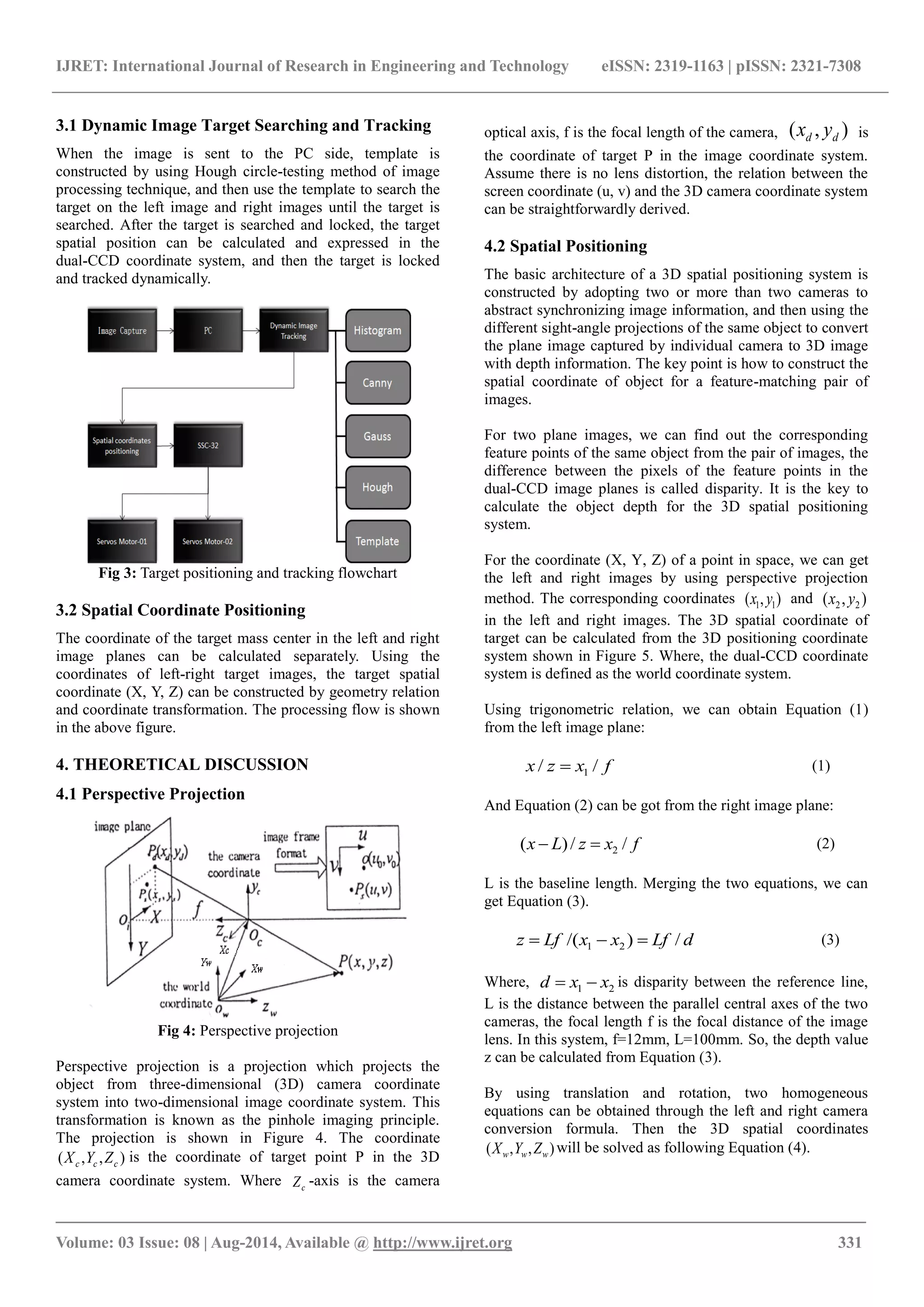
2. DESIGN OF SHOOTING TRAINING
SIMULATOR
This shooting training simulator includes three parts:
two-axis dual-CCD image-servo shooting platform, laser
shooting module, real-time monitoring.
Two-axis dual-CCD image-servo platform is equipped with
two cameras and two servo motors. Two cameras are used as
a major external feedback sensor which can provide
continuous image information to image processing module
for target identification, locking, positioning and tracking
tasks in real time.
Two-axis servo motors are driven by axis servo controller
SSC-32, which controls the two-axis rotations. As the target
is locked and positioned in the image plane, the platform
system will be driven to align, track and shoot to the target
with laser light. The results of real-time positioning and
shooting will be displayed on the monitor in client side.
2.1 System Architecture
The real-time monitoring system is implemented in client
side for human machine interaction. In the server side, using
the image processing and positioning technique, the target
coordinate (X,Y,Z) expressed in the dual-CCD coordinate
system can be calculated and transformed into the rotation
angles of two axes. And use the servo commands of SSC-32
servo controller [1], the shooting platform can be driven to
2. IJRET: International Journal of Research in Engineering and Technology eISSN: 2319-1163 | pISSN: 2321-7308
_______________________________________________________________________________________
Volume: 03 Issue: 08 | Aug-2014, Available @ http://www.ijret.org 330
aim to the target on the shooting line and the firing action is
done.
The SSC-32 controller is operated under the SSC-32
commands of PC server through RS-232 or Bluetooth
wireless module, and then the SSC-32 controller sends the
corresponding PWM (Pulse Width Modulation) control
signal to drive the servo motor. The overall system diagram is
shown in Figure 1.
Fig 1: System architecture block diagram
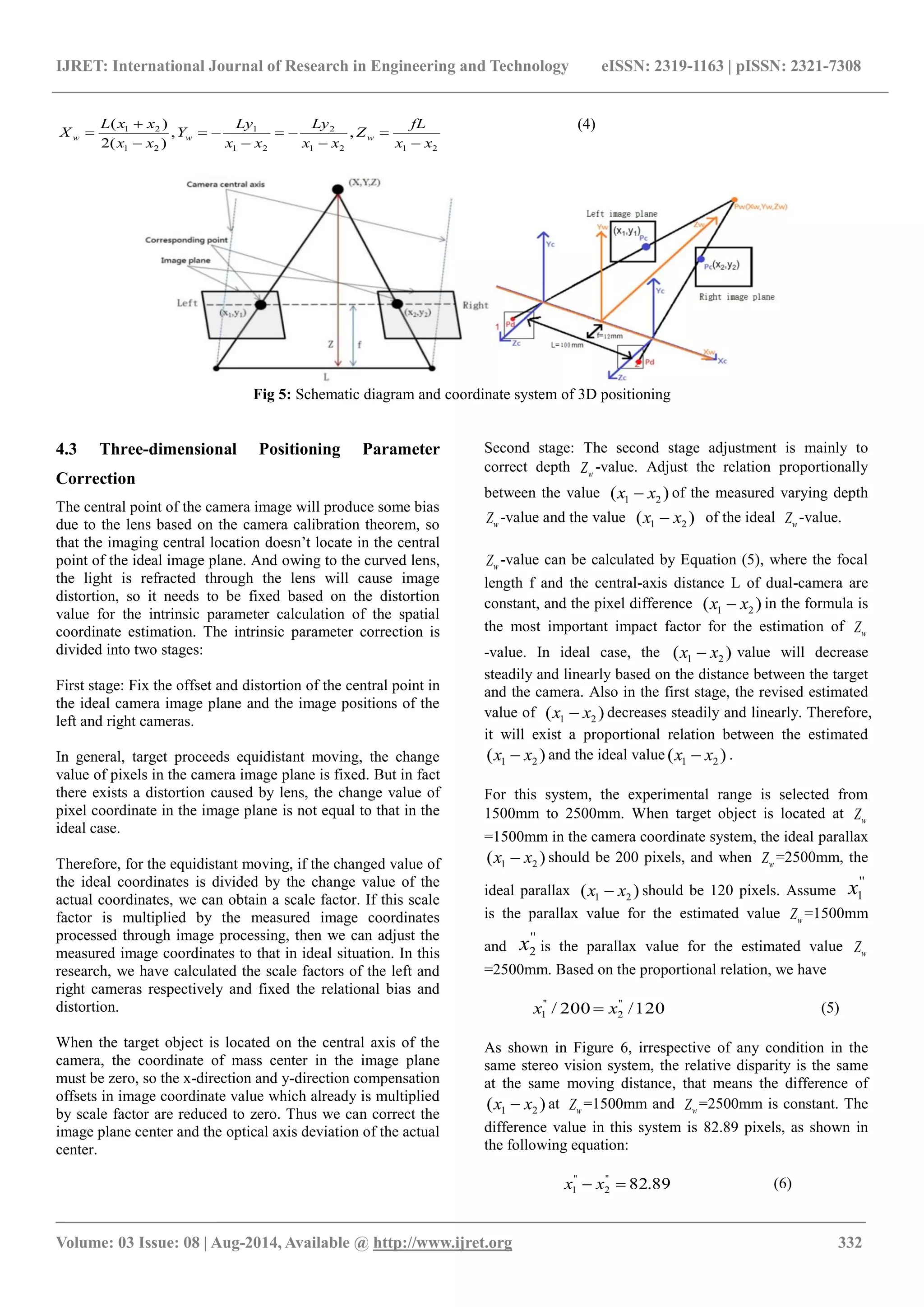
2.2 Hardware Architecture
From Figure 2, we know that the shooting platform includes
two servo motors for the driving of azimuth angle and
elevation angle and two CCD cameras for the positioning of
target. Based on two-axis rotations, we can rotate the
platform to aim at the target and then emit the laser light.
Laser emitting module is installed on the central point of the
left-right camera axis.
Fig 2: Geometry relation for dual cameras and two-axis shooting platform
2.3 Software Architecture
Software is developed by using Microsoft's C# programming,
which is the main development platform based on .NET
framework, a high-level object-oriented programming
language. In this research, we use EMGU CV [3, 4] as the
principal image capture and processing tool.
As the above statement, we use the Lynx motion SSC-32
servo controller, which provides a RS232 port and Bluetooth
wireless transmission module. This controller can control up
to 32 axes servo motors and promoted to the highest
resolution of 1us. In this research, the serial communication
baud rate is set to 115200 and the required PWM (Pulse
Width Modulation) command is sent to control the servo
motor.
3. ARCHITECTURE OF TRACKING AND
RECOGNIZING SYSTEM
In this study, the attitude of the motor-driven platform
determines the dual-CCD captured image area, and the image
is transferred to PC terminal by USB 3.0 interface, after the
target image is detected dynamically in PC terminal, we start
to run the tracking task and calculate the target position in
image space. Then we convert the spatial coordinate of target
position into the corresponding two-axis rotation angles,
which are the required motor-driven angles of SSC-32 servo
commands. Two processes must be done in the PC side. One
is dynamic image searching-tracking of target, the other is
spatial coordinate positioning as shown in the following:
3. IJRET: International Journal of Research in Engineering and Technology eISSN: 2319-1163 | pISSN: 2321-7308
_______________________________________________________________________________________
Volume: 03 Issue: 08 | Aug-2014, Available @ http://www.ijret.org 331
3.1 Dynamic Image Target Searching and Tracking
When the image is sent to the PC side, template is
constructed by using Hough circle-testing method of image
processing technique, and then use the template to search the
target on the left image and right images until the target is
searched. After the target is searched and locked, the target
spatial position can be calculated and expressed in the
dual-CCD coordinate system, and then the target is locked
and tracked dynamically.
Fig 3: Target positioning and tracking flowchart
3.2 Spatial Coordinate Positioning
The coordinate of the target mass center in the left and right
image planes can be calculated separately. Using the
coordinates of left-right target images, the target spatial
coordinate (X, Y, Z) can be constructed by geometry relation
and coordinate transformation. The processing flow is shown
in the above figure.
4. THEORETICAL DISCUSSION
4.1 Perspective Projection
Fig 4: Perspective projection
Perspective projection is a projection which projects the
object from three-dimensional (3D) camera coordinate
system into two-dimensional image coordinate system. This
transformation is known as the pinhole imaging principle.
The projection is shown in Figure 4. The coordinate
),,( ccc ZYX is the coordinate of target point P in the 3D
camera coordinate system. Where cZ -axis is the camera
optical axis, f is the focal length of the camera, ),( dd yx is
the coordinate of target P in the image coordinate system.
Assume there is no lens distortion, the relation between the
screen coordinate (u, v) and the 3D camera coordinate system
can be straightforwardly derived.
4.2 Spatial Positioning
The basic architecture of a 3D spatial positioning system is
constructed by adopting two or more than two cameras to
abstract synchronizing image information, and then using the
different sight-angle projections of the same object to convert
the plane image captured by individual camera to 3D image
with depth information. The key point is how to construct the
spatial coordinate of object for a feature-matching pair of
images.
For two plane images, we can find out the corresponding
feature points of the same object from the pair of images, the
difference between the pixels of the feature points in the
dual-CCD image planes is called disparity. It is the key to
calculate the object depth for the 3D spatial positioning
system.
For the coordinate (X, Y, Z) of a point in space, we can get
the left and right images by using perspective projection
method. The corresponding coordinates ),( 11 yx and ),( 22 yx
in the left and right images. The 3D spatial coordinate of
target can be calculated from the 3D positioning coordinate
system shown in Figure 5. Where, the dual-CCD coordinate
system is defined as the world coordinate system.
Using trigonometric relation, we can obtain Equation (1)
from the left image plane:
fxzx // 1 (1)
And Equation (2) can be got from the right image plane:
fxzLx //)( 2 (2)
L is the baseline length. Merging the two equations, we can
get Equation (3).
dLfxxLfz /)/( 21 (3)
Where, 21 xxd is disparity between the reference line,
L is the distance between the parallel central axes of the two
cameras, the focal length f is the focal distance of the image
lens. In this system, f=12mm, L=100mm. So, the depth value
z can be calculated from Equation (3).
By using translation and rotation, two homogeneous
equations can be obtained through the left and right camera
conversion formula. Then the 3D spatial coordinates
),,( www ZYX will be solved as following Equation (4).
4. IJRET: International Journal of Research in Engineering and Technology eISSN: 2319-1163 | pISSN: 2321-7308
_______________________________________________________________________________________
Volume: 03 Issue: 08 | Aug-2014, Available @ http://www.ijret.org 332
2121
2
21
1
21
21
,,
)(2
)(
xx
fL
Z
xx
Ly
xx
Ly
Y
xx
xxL
X www
(4)
Fig 5: Schematic diagram and coordinate system of 3D positioning
4.3 Three-dimensional Positioning Parameter
Correction
The central point of the camera image will produce some bias
due to the lens based on the camera calibration theorem, so
that the imaging central location doesn’t locate in the central
point of the ideal image plane. And owing to the curved lens,
the light is refracted through the lens will cause image
distortion, so it needs to be fixed based on the distortion
value for the intrinsic parameter calculation of the spatial
coordinate estimation. The intrinsic parameter correction is
divided into two stages:
First stage: Fix the offset and distortion of the central point in
the ideal camera image plane and the image positions of the
left and right cameras.
In general, target proceeds equidistant moving, the change
value of pixels in the camera image plane is fixed. But in fact
there exists a distortion caused by lens, the change value of
pixel coordinate in the image plane is not equal to that in the
ideal case.
Therefore, for the equidistant moving, if the changed value of
the ideal coordinates is divided by the change value of the
actual coordinates, we can obtain a scale factor. If this scale
factor is multiplied by the measured image coordinates
processed through image processing, then we can adjust the
measured image coordinates to that in ideal situation. In this
research, we have calculated the scale factors of the left and
right cameras respectively and fixed the relational bias and
distortion.
When the target object is located on the central axis of the
camera, the coordinate of mass center in the image plane
must be zero, so the x-direction and y-direction compensation
offsets in image coordinate value which already is multiplied
by scale factor are reduced to zero. Thus we can correct the
image plane center and the optical axis deviation of the actual
center.
Second stage: The second stage adjustment is mainly to
correct depth wZ -value. Adjust the relation proportionally
between the value )( 21 xx of the measured varying depth
wZ -value and the value )( 21 xx of the ideal wZ -value.
wZ -value can be calculated by Equation (5), where the focal
length f and the central-axis distance L of dual-camera are
constant, and the pixel difference )( 21 xx in the formula is
the most important impact factor for the estimation of wZ
-value. In ideal case, the )( 21 xx value will decrease
steadily and linearly based on the distance between the target
and the camera. Also in the first stage, the revised estimated
value of )( 21 xx decreases steadily and linearly. Therefore,
it will exist a proportional relation between the estimated
)( 21 xx and the ideal value )( 21 xx .
For this system, the experimental range is selected from
1500mm to 2500mm. When target object is located at wZ
=1500mm in the camera coordinate system, the ideal parallax
)( 21 xx should be 200 pixels, and when wZ =2500mm, the
ideal parallax )( 21 xx should be 120 pixels. Assume
''
1x
is the parallax value for the estimated value wZ =1500mm
and
''
2x is the parallax value for the estimated value wZ
=2500mm. Based on the proportional relation, we have
120/200/ ''
2
''
1 xx (5)
As shown in Figure 6, irrespective of any condition in the
same stereo vision system, the relative disparity is the same
at the same moving distance, that means the difference of
)( 21 xx at wZ =1500mm and wZ =2500mm is constant. The
difference value in this system is 82.89 pixels, as shown in
the following equation:
89.82''
2
''
1 xx (6)
5. IJRET: International Journal of Research in Engineering and Technology eISSN: 2319-1163 | pISSN: 2321-7308
_______________________________________________________________________________________
Volume: 03 Issue: 08 | Aug-2014, Available @ http://www.ijret.org 333
From the simultaneous equation, the two variables of
''
1x
and
''
2x can be solved. And then the corrected visual
difference of the depth 2500mm at the first stage can be
reduced to
''
2x ; Using the scaling factor, we can synthesize
the estimated wZ -value into the ideal wZ -value. Also,
substituting this (
''
1x -
''
2x ) value to the formula of Y-axis
equation, we will complete properly the calibration
procedure.
Fig 6: Relative disparity
4.4 Servo Control
In this target tracking system, we utilize image servo control
to get the spatial 3D position by using dual-camera as an
external smart sensor.
Servo motor is controlled by SSC32 control board with PWM
control signal. This system adopts GWS servo motor, its
scaling factor between the rotation angle and the pulse width
is 9 us/degree, means the servo motor rotates 1 degree when
the pulse width increases 9us.This factor is used as a
proportional controller parameter adjustment scale, the output
should be in proportion to the corresponding pulse width.
Adding the concept of image-servo outer loop feedback
controller, the calculated 3D spatial coordinate information is
used as the primary feedback signal, and using the pulse
width increasing or decreasing type with 50Hz to
approximate the mass center of target and make the feedback
error to minimum.
5. EXPERIMENTAL RESULT AND DISCUSSION
Experimental verification of this paper is divided into two
parts: one is 3D positioning, measurement and error analysis.
Another is the actual testing of the target tracking and aiming
capabilities. For 3D positioning, we have done the
measurements of the X-axis and Z-axis depth respectively
according to the proposed 3D spatial positioning method, the
range of X-axis measurement is from the-100mm to +100
mm, one data is measured per 5mm and total 41 data are
obtained; Z-axis depth is measured in the world coordinate
system from 1500mm to 2500mm, one data is measured per
10mm and total 101 data are obtained.
From the shown measurement data, the average error
between the X-axis measurement data and the desired
standard value is 0.19mm, the maximum error is 0.47mm,
this measurement results show that the proposed method of
positioning for the X-axis is accurate and the error is less
than 5mm. And the average error of Z-axis measurement data
is 3.47mm, the maximum error is 10mm.From the result data
of Table I, we can find out the error increases significantly
behind the distance of 2000mm, and the measured value
appears repeated phenomenon. The error source is
presumably due to the scaling adjustment of the proposed
correction method for Z-axis, so after the uniform scaling
adjustment at some distance, the measured data is not just fall
in the vicinity of the standard value. As for the duplicated
phenomenon of the measured value, mainly due to the
distance too far away and make the image moving distance
relative small on screen for the 10mm depth change. So the
system does not detect its changes and leads to the same
measurement result, which is also the main source of
measurement error. If the CCD resolution increases or the
distance L between the dual-camera lengths, this repeated
phenomenon problem can be solved.
This system is designed for the purpose of building
automation shooting training range, and can interact with the
intelligent target robot, so we plan 0-5 grade training courses
for 6 kinds of different conditions, which present the
interaction situation between the shooting training platform
and the intelligent target robot as described in the following:
Grade 0: This is a basic shooting training class which will
place the target at fixed point and drive the shooting
simulation system for target tracking and shooting.
Grade 1: The main purpose of this grade is to demonstrate
the shooting capability for target hiding and showing. The
shooting simulation system needs to be designed as it doesn’t
take any tracking and shooting action until the target appears
as shown in the following figures.
Grade 2: Target small angle shaking: The shooting
simulation system needs to be designed to track and shoot
target based on the shaking angle of target rotation.
Fig: 7 Static target looming mode and static target shaking
mode
Grade 3: Target moving around: The shooting simulation
system needs to be designed to track, lock and shoot target
continuously based on the forward-backward and left-right
moving of target.
6. IJRET: International Journal of Research in Engineering and Technology eISSN: 2319-1163 | pISSN: 2321-7308
_______________________________________________________________________________________
Volume: 03 Issue: 08 | Aug-2014, Available @ http://www.ijret.org 334
Grade 4: Hiding and showing in moving target: The
shooting simulation system needs to be designed to calculate
the target position and proceed with a tracking-shooting task
before the moving target hiding.
Grade 5: Target is moving from left to right and take a small
angle shaking in target moving.
6. CONCLUSIONS
This article uses Hough transform and Template matching
method to develop and construct three-dimensional dynamic
positioning and tracking system. Hough transform is updated
once every 30 milliseconds and the target image is saved as a
template. The template matching method is updated once
every 15 milliseconds, and then we can compare the left and
right images to find out the corresponding feature points.
Using these feature points, the 3D spatial coordinate can be
calculated.
According to experimental results, through the Hough circle
transform and template matching methods, the searched
target in the image searching mode is almost the locked
target accurately. Even the scene of target changes, we still
can find out correctly the target by using the assistance of
histogram equalization and then identify the target.
In the three-dimensional spatial positioning part, the spatial
positioning and correction method in this paper has been
validated. The experimental result shows that the
measurement is correct. But if the distortion of the selected
camera lens and the offsets of lens center are serious, then the
errors will increase relatively. The resolution is also a
problem needs to be overcome, if we can find out the
relationship of dual-camera distance and the resolution of
lens, then the same depth problem of the working distance
will be solved.
ACKNOWLEDGEMENTS
This research was sponsored by National Science Council,
Taiwan, R.O.C. under the grant NSC 102-2221-E-035-062
and NSC 102-2218-E-005-012.
REFERENCES
[1] R. Y. TSAI, “A Versatile Camera Calibration
Technique for High-Accuracy 3D Machine Vision
Metrology Using Off-the-shelf TV Cameras and
Lenses”, IEEE Journal of Robotics and Automation,
Vol.3, Issue 4, pp.323 – 344,1987.
[2] G. N. Desouza and A. C. Kak, "Vision for Mobile
Robot Navigation: a Survey", IEEE Transactions on
Pattern Analysis and Machine Intelligence, Vol.24,
pp. 237-267, Feb. 2002.
[3] Jae-Woong Yi, Tae Seok Yang, Jun-Ho Oh,
“Estimation of depth and 3D motion parameters of
moving objects with multiple stereo images by using
Kalman filter”, Proceedings of IEEE IECON 21st
international conference, Vol.2, pp.1225-1230, 1995.
[4] R. I. Hartley, “In Defense of the Eight-Point
Algorithm,” IEEE Transactions on Pattern Analysis
and Machine Intelligence, vol. 19, pp. 580-593, NO.
6, June 1997.
[5] Zhang, Z, “A Flexible New Technique for Camera
Calibration”, IEEE Transactions on Pattern Analysis
and Machine Intelligence, Vo1.22, pp. 1330-1334,
2000.