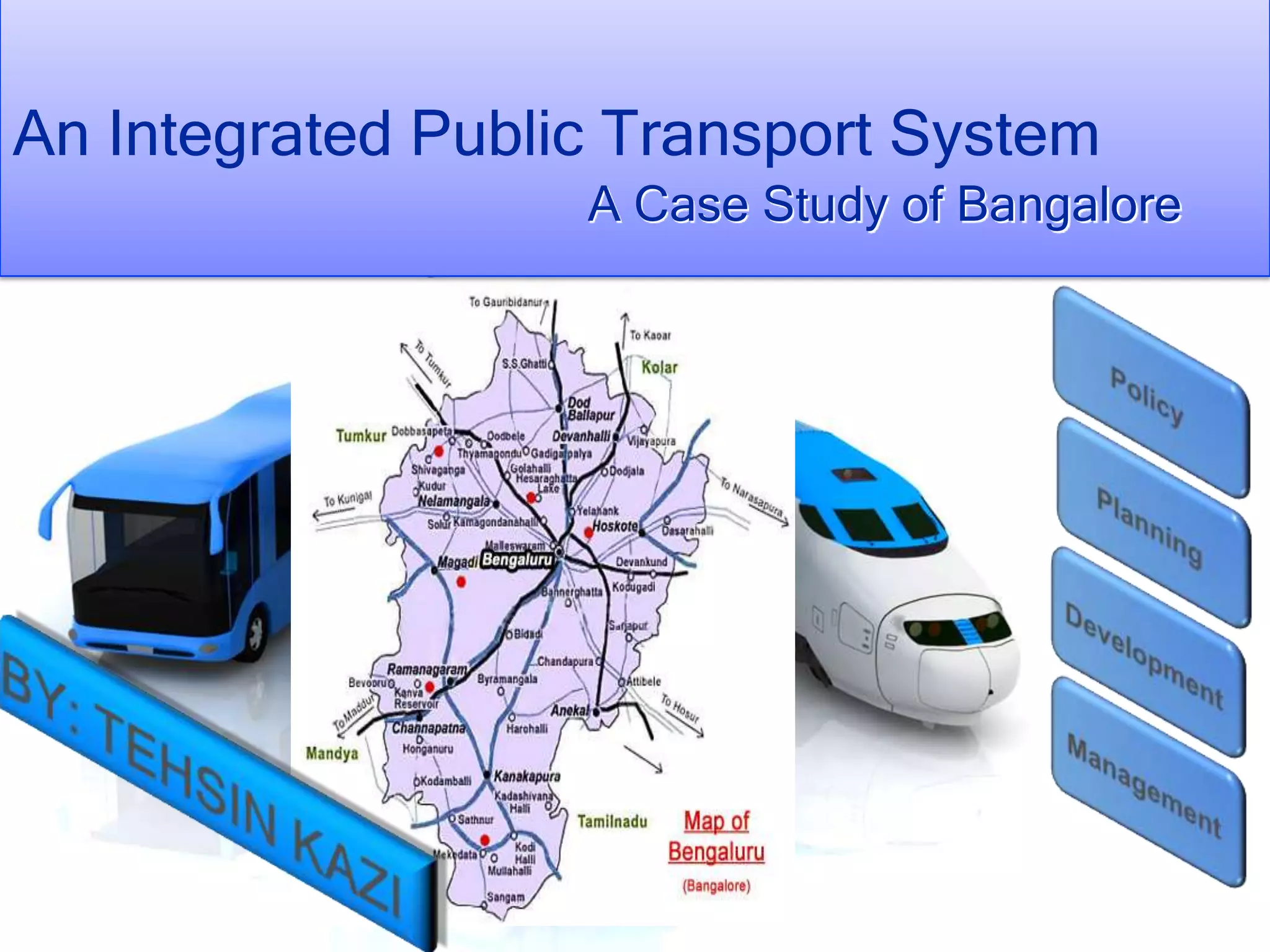
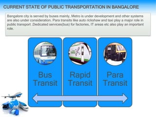
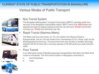
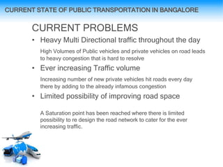
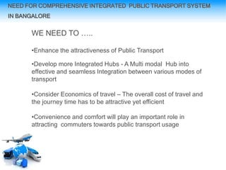
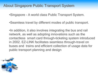
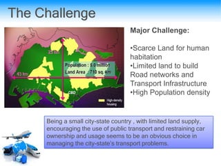
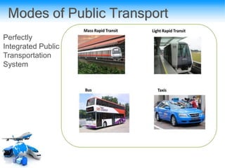
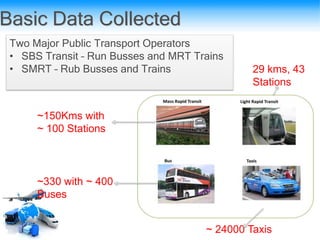
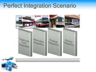
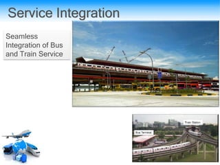
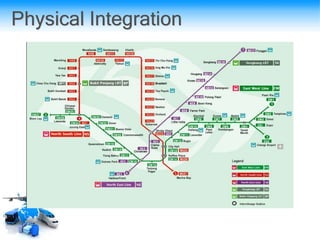
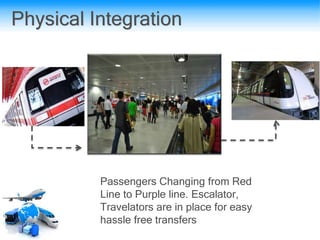
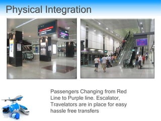
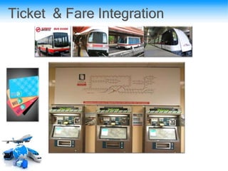
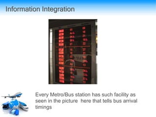
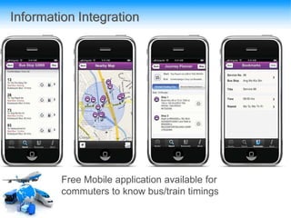
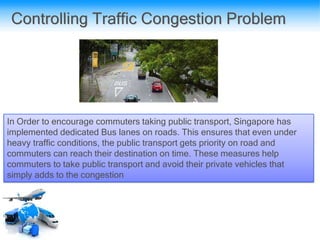
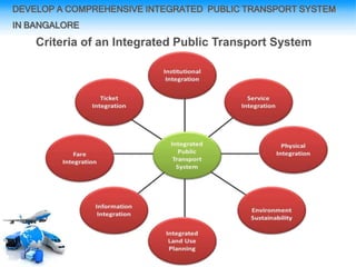
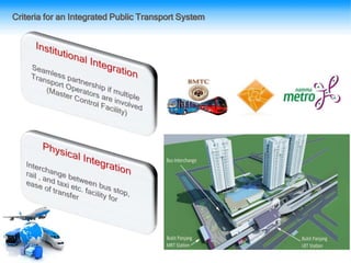
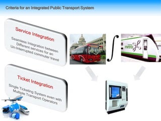
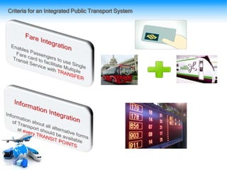
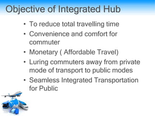
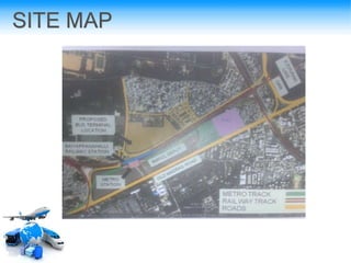
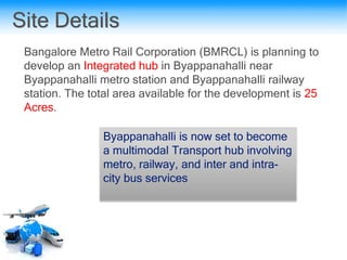
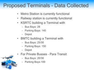
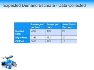
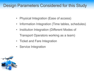
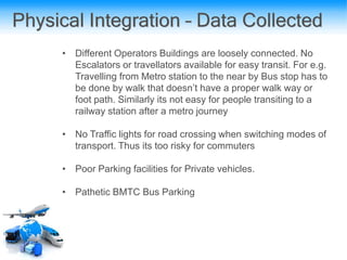
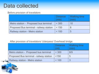
An Integrated Public Transport System
A Case Study of Bangalore
AGENDA
• INTRODUCTION
• NATIONAL URBAN TRANSPORT POLICY
• CURRENT STATE OF PUBLIC TRANSPORTATION IN
BANGALORE
• NEED FOR COMPREHENSIVE INTEGRATED PUBLIC
TRANSPORT SYSTEM IN BANGALORE
• EXMAPLES OF TRANSPORT INTERGATION ACROSS WORLD
• CASE STUDY OF BANGALORE
– SITE DETAILS
– DATA COLLECTION
– PROPOSAL FOR BYAPANHALLI TRANSIT HUB
• RECOMMDATIONS
INTRODUCTION
• Transport Integration means that
whatever modes or types of transport (rail, road, water,
'niche', air) are involved they all operate as one 'seamless'
entity - for the benefit of the fare paying customer.
• Barry J Simpson remarks that integration means the
speedy, convenient and economical connection of
services to make up complete journeys for passengers
from their origins to their final destinations. This should
include the integration of timetables, ticketing and
provision of facilities such as parking spaces for park and
ride; and also special services for the disabled or elderly
OBJECTIVE - NUTP
• Incorporating urban transportation as an important
parameter at the urban planning stage rather than being a
consequential requirement
• Encouraging integrated land use and transport planning
(Neighborhood planning /integrate townships that travel
distances are minimized and access to livelihoods,
education, and other social needs, especially for the
marginal segments of the urban population is improved
• Investing in transport systems that encourage greater use of
public transport and non-motorized modes instead of
personal motor vehicles
• Introducing Intelligent Transport Systems for traffic
management
CURRENT STATE OF PUBLIC TRANSPORTATION IN BANGALORE
Bangalore city is served by buses mainly, Metro is under development and other systems
are also under consideration. Para transits like auto rickshaw and taxi play a major role in
public transport .Dedicated services(bus) for factories, IT areas etc also play an important
role.
Bus
Transit
Rapid
Transit
Para
Transit
CURRENT STATE OF PUBLIC TRANSPORTATION IN BANGALORE
Various Modes of Public Transport
• Bus Transit System
The Bangalore Metropolitan Transport Corporation (BMTC) operates public bus
services in the Bangalore metropolitan region. BMTC owns over 3500 buses and
operates through six depots spread across the city and carry 30 lakh commuters
running over 10 lakh bus kilometres per day
• Rapid Transit (Namma Metro)
The Metro will have two tracks: an 18.1-km stretch from Mysore Road to
Byappanahalli, and an 18.4-km stretch from Yeshwantpur to R.V. Road, both via the
Kempegowda bus terminus. The travel time from one corridor to another will range
between 28-30 minutes with a carrying capacity of 40,000 peak hour peak direction
traffic
• Para Transit
Is an alternative mode of flexible passenger transportation that does not follow fixed
routes or schedules. The Para transit system in Bangalore comprises of
a. Auto Rickshaws
b. Taxis
CURRENT PROBLEMS
• Heavy Multi Directional traffic throughout the day
High Volumes of Public vehicles and private vehicles on road leads
to heavy congestion that is hard to resolve
• Ever increasing Traffic volume
Increasing number of new private vehicles hit roads every day
there by adding to the already infamous congestion
• Limited possibility of improving road space
A Saturation point has been reached where there is limited
possibility to re design the road network to cater for the ever
increasing traffic.
CURRENT STATE OF PUBLIC TRANSPORTATION IN BANGALORE
DEVELOPING A COMPREHENSIVE INTEGRATED
PUBLIC TRANSPORT SYSTEM IN BANGALORE
Ultimate Vision
NEED FOR COMPREHENSIVE INTEGRATED PUBLIC TRANSPORT SYSTEM
IN BANGALORE
WE NEED TO …..
•Enhance the attractiveness of Public Transport
•Develop more Integrated Hubs - A Multi modal Hub into
effective and seamless Integration between various modes of
transport
•Consider Economics of travel – The overall cost of travel and
the journey time has to be attractive yet efficient
•Convenience and comfort will play an important role in
attracting commuters towards public transport usage
About Singapore Public Transport System
•Singapore - A world class Public Transport System.
•Seamless travel by different modes of public transport.
•In addition, it also involves integrating the bus and rail
network, as well as adopting innovations such as the
contactless smart card through-ticketing system introduced
in 2002. EZ-LINK facilitates seamless through-travel on
buses and trains and efficient collection of usage data for
public transport planning and design
The Challenge
Major Challenge:
•Scarce Land for human
habitation
•Limited land to build
Road networks and
Transport Infrastructure
•High Population density
Being a small city-state country , with limited land supply,
encouraging the use of public transport and restraining car
ownership and usage seems to be an obvious choice in
managing the city-state’s transport problems.
Modes of Public Transport
Perfectly
Integrated Public
Transportation
System
Basic Data Collected
Two Major Public Transport Operators
• SBS Transit – Run Busses and MRT Trains
• SMRT – Rub Busses and Trains
~150Kms with
~ 100 Stations
~330 with ~ 400
Buses
~ 24000 Taxis
29 kms, 43
Stations
Perfect Integration Scenario
Service Integration
Seamless
Integration of Bus
and Train Service
Physical Integration
Passengers Changing from Red
Line to Purple line. Escalator,
Travelators are in place for easy
hassle free transfers
Physical Integration
Passengers Changing from Red
Line to Purple line. Escalator,
Travelators are in place for easy
hassle free transfers
Ticket & Fare Integration
Information Integration
Every Metro/Bus station has such facility as
seen in the picture here that tells bus arrival
timings
Information Integration
Free Mobile application available for
commuters to know bus/train timings
Addressing the Problem
•Singapore has a highly affordable and convenient
public transport – Infact one of the cheapest in the world
relative to infrastructure
•Higher levies on private vehicles
•Congestion pricing
•Dedicated bus lane
•Limit on vehicle registration
•Vehicle Quota and CEO – certificate of entitlement
Controlling Traffic Congestion Problem
Charges are levied on a per-pass basis, motorists are more aware of the true
cost of using their vehicles. Above images shows ERP Gantry installed on
congested highways
By pricing congested stretches, ERP system helps to moderate and spread
out vehicle usage for optimal usage of the road network by encouraging
motorists to consider alternatives
Controlling Traffic Congestion Problem
In Order to encourage commuters taking public transport, Singapore has
implemented dedicated Bus lanes on roads. This ensures that even under
heavy traffic conditions, the public transport gets priority on road and
commuters can reach their destination on time. These measures help
commuters to take public transport and avoid their private vehicles that
simply adds to the congestion
• Vehicle Quota system: Singapore has a vehicle quota
system that determines the number of vehicles on road.
Thus public has to apply for a permit to own a vehicle. The
permit is called Certificate of Entitlement (COE). The COE is
priced quite high so that it’s not easily affordable. This
measure helps in controlling the number of private vehicles
on road and in turn controlling the traffic.
• This Certificate of Entitlement (COE), designed by
Singapore government limits car ownership and number of
vehicles on country's roads
• COE allows holders to own a car for only 10 years
• This Certificate of Entitlement (COE),
designed by Singapore government
limits car ownership and number of
vehicles on country's roads
• COE allows holders to own a car for
only 10 years
DEVELOP A COMPREHENSIVE INTEGRATED PUBLIC TRANSPORT SYSTEM
IN BANGALORE
Criteria of an Integrated Public Transport System
Criteria for an Integrated Public Transport System
•PRESENCE OF METRO TERMINAL ,BUS (INTRA AND
INTER-CITY ), RAIL ETC
•PROPOSED TRANIST HUB
Objective of Integrated Hub
• To reduce total travelling time
• Convenience and comfort for
commuter
• Monetary ( Affordable Travel)
• Luring commuters away from private
mode of transport to public modes
• Seamless Integrated Transportation
for Public
SITE MAP
Site Details
Bangalore Metro Rail Corporation (BMRCL) is planning to
develop an Integrated hub in Byappanahalli near
Byappanahalli metro station and Byappanahalli railway
station. The total area available for the development is 25
Acres.
Byappanahalli is now set to become
a multimodal Transport hub involving
metro, railway, and inter and intra-
city bus services
Proposed Terminals – Data Collected
• Metro Station is currently functional
• Railway station is currently functional
• KSRTC building a Terminal with
– Bus Bays: 28
– Parking Bays: 140
– Depot
• BMTC building a Terminal with
– Bus Bays: 25/30
– Parking Bays: 150
– Depot
• For Private Busses – Para Transit
– Bus Bays: 20/30
– Parking Bays:100
Passengers
per hour
Busses per
Hour
Metro Trains
Per Hour
Morning
peak
7000 153 20
Night Peak 7385 192 20
Off Peak 5000 125 15
Expected Demand Estimate – Data Collected
Design Parameters Considered for this Study
• Physical Integration (Ease of access)
• Information Integration (Time tables, schedules)
• Institution Integration (Different Modes of
Transport Operators working as a team)
• Ticket and Fare Integration
• Service Integration
Physical Integration – Data Collected
• Different Operators Buildings are loosely connected. No
Escalators or travellators available for easy transit. For e.g.
Travelling from Metro station to the near by Bus stop has to
be done by walk that doesn’t have a proper walk way or
foot path. Similarly its not easy for people transiting to a
railway station after a metro journey
• No Traffic lights for road crossing when switching modes of
transport. Thus its too risky for commuters
• Poor Parking facilities for Private vehicles.
• Pathetic BMTC Bus Parking
Data collected
Distance
(mts)
Walking time
(min)
Metro station - Proposed bus terminal < 300 10
Proposed Bus terminal – railway station < 150 8
Railway station – Metro station < 100 5
Distance
(mt)
Walking time
(min)
Metro station - Proposed bus terminal < 300 8/9
Proposed Bus terminal – railway station <150 5
Railway station – Metro station < 100 3
After provision of travelators/ Uderpass/ Overhead bridge
Before provision of travelators
Information Integration – Data Collected
• The Bus schedules are almost
missing
• Metro Train schedules available
• Railway train schedules available
• However the above 3 are not well
integrated in a single display panel
Institutional Integration
• Currently BMTC and Namma Metro
operate exclusive of each other. Thus
a common planning system for a
better Integrated Public Transport
System is missing
Ticket and Fare Integration – Data Collected
• Ticket and Fare are not common
between BMTC and Namma Metro.
For e.g. My Travel to Byanppanahalli from
Yeshwantpur needed me to buy a ticket
for each mode of transport I took.
Service Integration – Data Collection
• Different Modes of Services are not yet
fully integrated at Byappanahalli. However
with the proposed Bus Hub it is expected
to operate seamlessly with Namma Metro
• However during my study I gathered that
at most of the metro stations, a bus stop
that is quite a walkable distance exists.
Thus easing transit between different
modes of public transport

Integrated Public Transport System - Bangalore

  • 1.
    An Integrated PublicTransport System A Case Study of Bangalore
  • 2.
    AGENDA • INTRODUCTION • NATIONALURBAN TRANSPORT POLICY • CURRENT STATE OF PUBLIC TRANSPORTATION IN BANGALORE • NEED FOR COMPREHENSIVE INTEGRATED PUBLIC TRANSPORT SYSTEM IN BANGALORE • EXMAPLES OF TRANSPORT INTERGATION ACROSS WORLD • CASE STUDY OF BANGALORE – SITE DETAILS – DATA COLLECTION – PROPOSAL FOR BYAPANHALLI TRANSIT HUB • RECOMMDATIONS
  • 3.
    INTRODUCTION • Transport Integrationmeans that whatever modes or types of transport (rail, road, water, 'niche', air) are involved they all operate as one 'seamless' entity - for the benefit of the fare paying customer. • Barry J Simpson remarks that integration means the speedy, convenient and economical connection of services to make up complete journeys for passengers from their origins to their final destinations. This should include the integration of timetables, ticketing and provision of facilities such as parking spaces for park and ride; and also special services for the disabled or elderly
  • 5.
    OBJECTIVE - NUTP •Incorporating urban transportation as an important parameter at the urban planning stage rather than being a consequential requirement • Encouraging integrated land use and transport planning (Neighborhood planning /integrate townships that travel distances are minimized and access to livelihoods, education, and other social needs, especially for the marginal segments of the urban population is improved • Investing in transport systems that encourage greater use of public transport and non-motorized modes instead of personal motor vehicles • Introducing Intelligent Transport Systems for traffic management
  • 7.
    CURRENT STATE OFPUBLIC TRANSPORTATION IN BANGALORE Bangalore city is served by buses mainly, Metro is under development and other systems are also under consideration. Para transits like auto rickshaw and taxi play a major role in public transport .Dedicated services(bus) for factories, IT areas etc also play an important role. Bus Transit Rapid Transit Para Transit
  • 8.
    CURRENT STATE OFPUBLIC TRANSPORTATION IN BANGALORE Various Modes of Public Transport • Bus Transit System The Bangalore Metropolitan Transport Corporation (BMTC) operates public bus services in the Bangalore metropolitan region. BMTC owns over 3500 buses and operates through six depots spread across the city and carry 30 lakh commuters running over 10 lakh bus kilometres per day • Rapid Transit (Namma Metro) The Metro will have two tracks: an 18.1-km stretch from Mysore Road to Byappanahalli, and an 18.4-km stretch from Yeshwantpur to R.V. Road, both via the Kempegowda bus terminus. The travel time from one corridor to another will range between 28-30 minutes with a carrying capacity of 40,000 peak hour peak direction traffic • Para Transit Is an alternative mode of flexible passenger transportation that does not follow fixed routes or schedules. The Para transit system in Bangalore comprises of a. Auto Rickshaws b. Taxis
  • 9.
    CURRENT PROBLEMS • HeavyMulti Directional traffic throughout the day High Volumes of Public vehicles and private vehicles on road leads to heavy congestion that is hard to resolve • Ever increasing Traffic volume Increasing number of new private vehicles hit roads every day there by adding to the already infamous congestion • Limited possibility of improving road space A Saturation point has been reached where there is limited possibility to re design the road network to cater for the ever increasing traffic. CURRENT STATE OF PUBLIC TRANSPORTATION IN BANGALORE
  • 10.
    DEVELOPING A COMPREHENSIVEINTEGRATED PUBLIC TRANSPORT SYSTEM IN BANGALORE
  • 11.
  • 12.
    NEED FOR COMPREHENSIVEINTEGRATED PUBLIC TRANSPORT SYSTEM IN BANGALORE WE NEED TO ….. •Enhance the attractiveness of Public Transport •Develop more Integrated Hubs - A Multi modal Hub into effective and seamless Integration between various modes of transport •Consider Economics of travel – The overall cost of travel and the journey time has to be attractive yet efficient •Convenience and comfort will play an important role in attracting commuters towards public transport usage
  • 15.
    About Singapore PublicTransport System •Singapore - A world class Public Transport System. •Seamless travel by different modes of public transport. •In addition, it also involves integrating the bus and rail network, as well as adopting innovations such as the contactless smart card through-ticketing system introduced in 2002. EZ-LINK facilitates seamless through-travel on buses and trains and efficient collection of usage data for public transport planning and design
  • 16.
    The Challenge Major Challenge: •ScarceLand for human habitation •Limited land to build Road networks and Transport Infrastructure •High Population density Being a small city-state country , with limited land supply, encouraging the use of public transport and restraining car ownership and usage seems to be an obvious choice in managing the city-state’s transport problems.
  • 17.
    Modes of PublicTransport Perfectly Integrated Public Transportation System
  • 18.
    Basic Data Collected TwoMajor Public Transport Operators • SBS Transit – Run Busses and MRT Trains • SMRT – Rub Busses and Trains ~150Kms with ~ 100 Stations ~330 with ~ 400 Buses ~ 24000 Taxis 29 kms, 43 Stations
  • 19.
  • 22.
  • 23.
  • 24.
    Physical Integration Passengers Changingfrom Red Line to Purple line. Escalator, Travelators are in place for easy hassle free transfers
  • 25.
    Physical Integration Passengers Changingfrom Red Line to Purple line. Escalator, Travelators are in place for easy hassle free transfers
  • 26.
    Ticket & FareIntegration
  • 27.
    Information Integration Every Metro/Busstation has such facility as seen in the picture here that tells bus arrival timings
  • 28.
    Information Integration Free Mobileapplication available for commuters to know bus/train timings
  • 30.
    Addressing the Problem •Singaporehas a highly affordable and convenient public transport – Infact one of the cheapest in the world relative to infrastructure •Higher levies on private vehicles •Congestion pricing •Dedicated bus lane •Limit on vehicle registration •Vehicle Quota and CEO – certificate of entitlement
  • 31.
    Controlling Traffic CongestionProblem Charges are levied on a per-pass basis, motorists are more aware of the true cost of using their vehicles. Above images shows ERP Gantry installed on congested highways By pricing congested stretches, ERP system helps to moderate and spread out vehicle usage for optimal usage of the road network by encouraging motorists to consider alternatives
  • 32.
    Controlling Traffic CongestionProblem In Order to encourage commuters taking public transport, Singapore has implemented dedicated Bus lanes on roads. This ensures that even under heavy traffic conditions, the public transport gets priority on road and commuters can reach their destination on time. These measures help commuters to take public transport and avoid their private vehicles that simply adds to the congestion
  • 33.
    • Vehicle Quotasystem: Singapore has a vehicle quota system that determines the number of vehicles on road. Thus public has to apply for a permit to own a vehicle. The permit is called Certificate of Entitlement (COE). The COE is priced quite high so that it’s not easily affordable. This measure helps in controlling the number of private vehicles on road and in turn controlling the traffic. • This Certificate of Entitlement (COE), designed by Singapore government limits car ownership and number of vehicles on country's roads • COE allows holders to own a car for only 10 years
  • 34.
    • This Certificateof Entitlement (COE), designed by Singapore government limits car ownership and number of vehicles on country's roads • COE allows holders to own a car for only 10 years
  • 36.
    DEVELOP A COMPREHENSIVEINTEGRATED PUBLIC TRANSPORT SYSTEM IN BANGALORE Criteria of an Integrated Public Transport System
  • 37.
    Criteria for anIntegrated Public Transport System
  • 38.
    Criteria for anIntegrated Public Transport System
  • 39.
    Criteria for anIntegrated Public Transport System
  • 41.
    •PRESENCE OF METROTERMINAL ,BUS (INTRA AND INTER-CITY ), RAIL ETC •PROPOSED TRANIST HUB
  • 42.
    Objective of IntegratedHub • To reduce total travelling time • Convenience and comfort for commuter • Monetary ( Affordable Travel) • Luring commuters away from private mode of transport to public modes • Seamless Integrated Transportation for Public
  • 43.
  • 45.
    Site Details Bangalore MetroRail Corporation (BMRCL) is planning to develop an Integrated hub in Byappanahalli near Byappanahalli metro station and Byappanahalli railway station. The total area available for the development is 25 Acres. Byappanahalli is now set to become a multimodal Transport hub involving metro, railway, and inter and intra- city bus services
  • 46.
    Proposed Terminals –Data Collected • Metro Station is currently functional • Railway station is currently functional • KSRTC building a Terminal with – Bus Bays: 28 – Parking Bays: 140 – Depot • BMTC building a Terminal with – Bus Bays: 25/30 – Parking Bays: 150 – Depot • For Private Busses – Para Transit – Bus Bays: 20/30 – Parking Bays:100
  • 48.
    Passengers per hour Busses per Hour MetroTrains Per Hour Morning peak 7000 153 20 Night Peak 7385 192 20 Off Peak 5000 125 15 Expected Demand Estimate – Data Collected
  • 49.
    Design Parameters Consideredfor this Study • Physical Integration (Ease of access) • Information Integration (Time tables, schedules) • Institution Integration (Different Modes of Transport Operators working as a team) • Ticket and Fare Integration • Service Integration
  • 50.
    Physical Integration –Data Collected • Different Operators Buildings are loosely connected. No Escalators or travellators available for easy transit. For e.g. Travelling from Metro station to the near by Bus stop has to be done by walk that doesn’t have a proper walk way or foot path. Similarly its not easy for people transiting to a railway station after a metro journey • No Traffic lights for road crossing when switching modes of transport. Thus its too risky for commuters • Poor Parking facilities for Private vehicles. • Pathetic BMTC Bus Parking
  • 51.
    Data collected Distance (mts) Walking time (min) Metrostation - Proposed bus terminal < 300 10 Proposed Bus terminal – railway station < 150 8 Railway station – Metro station < 100 5 Distance (mt) Walking time (min) Metro station - Proposed bus terminal < 300 8/9 Proposed Bus terminal – railway station <150 5 Railway station – Metro station < 100 3 After provision of travelators/ Uderpass/ Overhead bridge Before provision of travelators
  • 52.
    Information Integration –Data Collected • The Bus schedules are almost missing • Metro Train schedules available • Railway train schedules available • However the above 3 are not well integrated in a single display panel
  • 53.
    Institutional Integration • CurrentlyBMTC and Namma Metro operate exclusive of each other. Thus a common planning system for a better Integrated Public Transport System is missing
  • 54.
    Ticket and FareIntegration – Data Collected • Ticket and Fare are not common between BMTC and Namma Metro. For e.g. My Travel to Byanppanahalli from Yeshwantpur needed me to buy a ticket for each mode of transport I took.
  • 55.
    Service Integration –Data Collection • Different Modes of Services are not yet fully integrated at Byappanahalli. However with the proposed Bus Hub it is expected to operate seamlessly with Namma Metro • However during my study I gathered that at most of the metro stations, a bus stop that is quite a walkable distance exists. Thus easing transit between different modes of public transport

Editor's Notes

  • #4 If I have to quote barrysimpson
  • #6 NOW LETS START WITH WHAT ARE THE GOVT PLANS TO ENSURE A BETTER PUBLIC TRANSPORT/TRANSIT SYSTEM FOR INDIA AS A WHOLE