SlideShare a Scribd company logo
International
OPEN ACCESS Journal
Of Modern Engineering Research (IJMER)
| IJMER | ISSN: 2249–6645 | www.ijmer.com | Vol. 4 | Iss. 6| June. 2014 | 42|
GIS based Road Network Assessment using Open source
Technology
Paru Thakkar1
, Krunal Patel2
, Movva Lakshmi Mounica3
1, 2
Bhaskaracharya Institute for Space Applications and Geo-informatics(BISAG),Department of Science &
Technology, Government of Gujarat
3
Department of Computer Science, GITAM University, Visakhapatnam, India
I. INTRODUCTION
In Developing countries an extensive and well-maintained network of primary, secondary, and feeder
roads is critical for economic growth and poverty alleviation. Because of their high and diverse functionality
and wide range of beneficiaries, roads have become an essential component of all national transport systems,
usually consuming the greatest proportion of public and private investment resources in both infrastructure and
services. Road Agencies in turn are required to deliver high quality road projects in time and according to the
budgetary allocations. Use of obsolete methods and technology must be avoided. Proper steps should be taken
by considering into account, the recent survey reports and analyze the loop holes in this system and try to bring
in a change. This calls for the need to develop a strong and well developed road transportation system.
This app helps one to visit any site/road and get a detailed report about the condition and maintenance
of that particular road based on the user‟s current GPS location. One can easily avoid duplication in the
process of resurfacing of bad roads, as the app provides clear information of the dates, when a particular road
was modified last. There is also a provision to retrieve data about all the roads in a particular city that are
either in good or bad condition so that necessary action can be taken accordingly, thus building a healthy road
transportation system to ensure easy and safe flow of men and material around the world.
The GPS (Global Positioning System) a space-based satellite navigation system that provides location
and time information in all weather conditions, anywhere on or near the Earth where there is an unobstructed
line of sight to four or more GPS satellites. The system provides critical capabilities to military, civil and
commercial users around the world. It is maintained by the United States government and is freely accessible
to anyone with a GPS receiver.
This feature, used in the app helps user to retrieve his current location and displays the details of the
road that he is presently at. This helps him to analyze and develop a detailed report about when the road was
last resurfaced and how many times were it reconstructed in the past decade. Based on this report the
concerned authorities can make a decision whether to include this particular road in their next development
plan or not.
Abstract: Finding one’s way with a map is a relatively recent phenomenon. In pre-modern times, maps
were used, if at all, mainly for planning journeys in advance, not for guiding travelers on the road.
The app “Road Factor”, build to run on any android platform, provides the condition of the roads in a
selected city or area by tracking your GPS location. It provides data that would help our government to
know the conditions of the roads in a particular area and take necessary measures accordingly. One can
easily know when and how many times a particular road was modified in the past ten years. This app also
facilitates easy governance and monitoring of the roads in an area. The app has a user friendly interface
that allows an individual to select his state ,city and the road whose condition is to be viewed.
the content of the paper. Try to keep the abstract below 200 words. Do not make references nor display
equations in the abstract. The journal will be printed from the same-sized copy prepared by you. Your
manuscript should be printed on A4 paper (21.0 cm x 29.7 cm). It is imperative that the margins and style
described below be adhered to carefully. This will enable us to keep uniformity in the final printed copies
of the Journal. Please keep in mind that the manuscript you prepare will be photographed and printed as
it is received. Readability of copy is of paramount importance. (10 Italic)
Keywords (11Bold): About five key words in alphabetical order, separated by comma (10 Italic)
GIS based Road Network Assessment using Open source Technology
| IJMER | ISSN: 2249–6645 | www.ijmer.com | Vol. 4 | Iss. 6| June. 2014 | 43|
II. METHODOLOGY
III. GOVERNANCE AND MONITORING
The fact that transportation is a service with great social importance, significant externalities, and
public good characteristics is at the heart of governance problems in the sector. Roads are a classic example of
a “public good”: roads are often non-excludable, and non-rival (except at high levels of congestion). Central
and state governments overwhelmingly fund roads because of their social importance. Because of road‟s public
good characteristics, road funding typically comes from general taxation or a levy on road users (for instance, a
petrol tax or vehicle registration charges), or both, rather than through user fees.
This app facilitates easy governance by monitoring the rate and quality of work done by the officials at
the site by tracking their GPS location on a particular day and the report submitted by them. This prevents
malpractices which usually occur in this field by monitoring how sincerely and effectively each employee is
working and developing an intelligent Road Investment Strategy.
By using the data obtained from this system we can set up new, discrete units – „Road User Focus‟
within Passenger Focus and a „Strategic Road Network Monitor‟ within the Office of Rail Regulation to repre-
GIS based Road Network Assessment using Open source Technology
| IJMER | ISSN: 2249–6645 | www.ijmer.com | Vol. 4 | Iss. 6| June. 2014 |
44|
sent the interests of all those who use and rely upon the strategic road network, and to monitor the efficiency
and performance of the workers.
During emergencies, it is critical for the road management authorities to be able to collect and report
current road status and damage assessments in a consistent and timely manner. Use of this application would
enable the corresponding supervisors and managers to deploy limited department resources most effectively. In
addition this app provides current road status information and report on the progress of response activities.
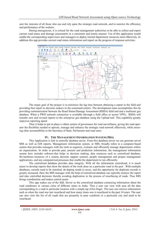
The major goal of the project is to minimize the lag time between obtaining a report in the field and
providing that report to decision makers in the command centers. The development team accomplishes this by
providing communication between the Road Status/Damage Assessment (RSDA) field tool and a multiuser geo
database. When a PWD network connection is available (through a field office or secure VPN), RSDA will
transfer new and revised reports to the enterprise geo database using the Upload tool. This capability greatly
improves reporting speed.
Thus it helps to put in place a robust system of governance for road surveillance, giving the road oper-
ator the flexibility needed to operate, manage and enhance the strategic road network effectively, while ensur-
ing clear accountability to the Secretary of State, Parliament and road users.
IV. THE MANAGEMENT INFORMATION SYSTEM (MIS)
This Application is link to centrally database server. From this database server we can generate serval
MIS as well as GIS reports. Management information system, or MIS, broadly refers to a computer-based
system that provides managers with the tools to organize, evaluate and efficiently manage departments within
an organization. In order to provide past, present and prediction information, the management information
system here includes software that helps in decision making, data resources such as centralized database,
the hardware resources of a system, decision support systems, people management and project management
applications, and any computerized processes that enable the department to run efficiently.
The centralized database provides data integrity. With all the information centralized, it is much
easier to develop reports that show the details of the work done on a particular road in the past . With multiple
databases, records need to be matched, de-duping needs to occur, and the opportunity for duplicate records is
greatly increased. Here the MIS manager with the help of centralized database can typically analyze the report
and take controlled decisions thereby avoiding duplication in the process of resurfacing of roads. Thus MIS
brings coordination and makes control easier.
This app makes use of the SQL Server as the centralized database containing information about the
road conditions in various cities of different states in India. Thus a user can view with ease all the data
corresponding to a road in particular location with a simple tap of his finger. The user can retrieve information
such as when the road was last resurfaced and how many times was it resurfaced in the past 10 years. The user
can also view the list of all roads that are presently in poor condition in a particular city and need to be
resurfaced.
GIS based Road Network Assessment using Open source Technology
| IJMER | ISSN: 2249–6645 | www.ijmer.com | Vol. 4 | Iss. 6| June. 2014 | 45|
V. POSSIBLE FUTURE IMPROVEMENTS
PWD emergency operations centers can be set up in every state that use information collected by
RSDA to prioritize repair and cleanup work. The map-based view of damage assessments can provide crews
with a view of problems nearby, allowing more work to be accomplished on a single trip. The RSDA Viewer
could be provided and thus by using the same operational picture at both locations, the state and county can
coordinate their response activities better.
This application can be used for assessment of the hazardous materials transport risk in a multi-
commodity, multiple origin – destination setting. The risk assessment methodology can be integrated with a
Geographical Information System (GIS), which can make large-scale implementation possible. A GIS-based
model of the shipments of dangerous goods via the highway network can be developed. Based on the origin
and destination of each shipment, the risk associated with the routes that minimize (1) the transport distance,
(2) the population exposure, (3) the expected number of people to be evacuated in case of an incident, and (4)
the probability of an incident during transportation can be evaluated. Using these assessments, a government
agency can estimate the impact of alternative policies that could alter the carriers‟ route choices. A related
issue is the spatial distribution of transport risk, because an unfair distribution is likely to cause public concern.
Thus, an analysis of transport risk equity in every state can be provided.
VI. CONCLUSION
A proper implementation of this app would be useful to a large section of people in different ways.
Common people can use it as a reference while travelling in order to decide which road to take. The GPS
feature used in this app helps track the current user location and provide details based on it. This app provides
the PWD department with the necessary data about the condition of the roads which helps them to take
necessary actions for the development of an efficient transportation system in the city. With proper centralized
road network assessment data in hand the PWD department can plan the budget accordingly and allocate
money for the same. At the same time ensuring that the same road is not resurfaced repeatedly irrespective of
its condition.
Thus implementing an e-Governance of roads through mobile apps and various other software ensures
improvements in planning, implementation and operation of the road sector through provision of timely,
reliable, sufficient and accurate detailed data which will facilitate the decision making activities.
ACKNOWLEDGEMENTS
The authors like to express their sincere thanks to Shri T.P. Singh, Director, Bhaskarcharya Institute
for Space Applications and Geo-informatics (BISAG), Department of Science & Technology, Government of
Gujarat, Gandhinagar-382 007 for his constant encouragement, guidance and kind permission to carry out this
project.
REFERENCES
Books:
[1] Shane Conder and Lauren Darcey, Android Wireless Application Development (Addisen-Wesely, Boston,2010).
[2] GIS Fundamentals, 4th Edition. Softcover available for $39, from Atlas Books, www.atlasbooks.com, 800-247-
6553. ISBN 978-0-9717647-3-6
[3] www.gislounge.com/free-gis-books/
Internet:
[4] http://www.w3schools.com
[5] http://www.javacodegeekss.com
[6] http://youtube.com –video tutorials

More Related Content

What's hot

Utilizing GIS to Develop a Non-Signalized Intersection Data Inventory for Saf...
Utilizing GIS to Develop a Non-Signalized Intersection Data Inventory for Saf...Utilizing GIS to Develop a Non-Signalized Intersection Data Inventory for Saf...
Utilizing GIS to Develop a Non-Signalized Intersection Data Inventory for Saf...
IJERA Editor
 
Transportation service innovation through big data
Transportation service innovation through big data Transportation service innovation through big data
Transportation service innovation through big data
cityprojectdevelopment
 
Traffic Access and Impact Study Guidelines & Procedures
Traffic Access and Impact Study Guidelines & ProceduresTraffic Access and Impact Study Guidelines & Procedures
Traffic Access and Impact Study Guidelines & Procedures
gscplanning
 
Week 8: The digital city
Week 8: The digital cityWeek 8: The digital city
Week 8: The digital city
Greg Wass
 
Smart Transport Facility
Smart Transport FacilitySmart Transport Facility
Smart Transport Facility
GAURAV. H .TANDON
 
CK2017: Leveraging Open and Standardized Data for Land-Use and Transportation...
CK2017: Leveraging Open and Standardized Data for Land-Use and Transportation...CK2017: Leveraging Open and Standardized Data for Land-Use and Transportation...
CK2017: Leveraging Open and Standardized Data for Land-Use and Transportation...
WRI Ross Center for Sustainable Cities
 
Geospatial technologies in urban planning
Geospatial technologies in urban planning Geospatial technologies in urban planning
Geospatial technologies in urban planning
Vikas Razdan
 
BE-GOOD Challenges - factsheet 2017-06
BE-GOOD Challenges - factsheet 2017-06BE-GOOD Challenges - factsheet 2017-06
BE-GOOD Challenges - factsheet 2017-06
Slim Turki, Dr.
 
Yinhai Wang - Smart Transportation: Research under Smart Cities Context - GCS16
Yinhai Wang - Smart Transportation: Research under Smart Cities Context - GCS16Yinhai Wang - Smart Transportation: Research under Smart Cities Context - GCS16
Yinhai Wang - Smart Transportation: Research under Smart Cities Context - GCS16
KC Digital Drive
 
Miami-Dade Accessibility Based Needs Assessment presentation
Miami-Dade Accessibility Based Needs Assessment presentationMiami-Dade Accessibility Based Needs Assessment presentation
Miami-Dade Accessibility Based Needs Assessment presentation
Miami-Dade Transportation Planning Organization
 
Research summary on ITS in Europe
Research summary on ITS in Europe Research summary on ITS in Europe
Research summary on ITS in Europe
Mital Damani
 
Importance of GPS in Transport
Importance of GPS in TransportImportance of GPS in Transport
Importance of GPS in Transport
WebXpress.IN
 
Data based planning optimizes public transport capacity utilization
Data based planning optimizes public transport capacity utilizationData based planning optimizes public transport capacity utilization
Data based planning optimizes public transport capacity utilization
Manfred Bock
 
[2015 e-Government Program] Action Plan : Wuhan(China)
[2015 e-Government Program] Action Plan : Wuhan(China)[2015 e-Government Program] Action Plan : Wuhan(China)
[2015 e-Government Program] Action Plan : Wuhan(China)
shrdcinfo
 
CK2017: Celebrating Cities: Collaborating for Smarter Cities
CK2017: Celebrating Cities: Collaborating for Smarter CitiesCK2017: Celebrating Cities: Collaborating for Smarter Cities
CK2017: Celebrating Cities: Collaborating for Smarter Cities
WRI Ross Center for Sustainable Cities
 
MDX SR836 BERT presentation
MDX SR836 BERT presentationMDX SR836 BERT presentation
Techniques for Smart Traffic Control: An In-depth Review
Techniques for Smart Traffic Control: An In-depth ReviewTechniques for Smart Traffic Control: An In-depth Review
Techniques for Smart Traffic Control: An In-depth Review
Editor IJCATR
 
Intelligent Transportation Systems - History & National Perspective
Intelligent Transportation Systems - History & National PerspectiveIntelligent Transportation Systems - History & National Perspective
Intelligent Transportation Systems - History & National Perspective
American Society of Civil Engineers, Orange County Branch
 
Au_MetroCount_Full_Brochure
Au_MetroCount_Full_BrochureAu_MetroCount_Full_Brochure
Au_MetroCount_Full_BrochureDale Luelf
 

What's hot (20)

Utilizing GIS to Develop a Non-Signalized Intersection Data Inventory for Saf...
Utilizing GIS to Develop a Non-Signalized Intersection Data Inventory for Saf...Utilizing GIS to Develop a Non-Signalized Intersection Data Inventory for Saf...
Utilizing GIS to Develop a Non-Signalized Intersection Data Inventory for Saf...
 
Transportation service innovation through big data
Transportation service innovation through big data Transportation service innovation through big data
Transportation service innovation through big data
 
Traffic Access and Impact Study Guidelines & Procedures
Traffic Access and Impact Study Guidelines & ProceduresTraffic Access and Impact Study Guidelines & Procedures
Traffic Access and Impact Study Guidelines & Procedures
 
Week 8: The digital city
Week 8: The digital cityWeek 8: The digital city
Week 8: The digital city
 
Smart Transport Facility
Smart Transport FacilitySmart Transport Facility
Smart Transport Facility
 
CK2017: Leveraging Open and Standardized Data for Land-Use and Transportation...
CK2017: Leveraging Open and Standardized Data for Land-Use and Transportation...CK2017: Leveraging Open and Standardized Data for Land-Use and Transportation...
CK2017: Leveraging Open and Standardized Data for Land-Use and Transportation...
 
Geospatial technologies in urban planning
Geospatial technologies in urban planning Geospatial technologies in urban planning
Geospatial technologies in urban planning
 
BE-GOOD Challenges - factsheet 2017-06
BE-GOOD Challenges - factsheet 2017-06BE-GOOD Challenges - factsheet 2017-06
BE-GOOD Challenges - factsheet 2017-06
 
Yinhai Wang - Smart Transportation: Research under Smart Cities Context - GCS16
Yinhai Wang - Smart Transportation: Research under Smart Cities Context - GCS16Yinhai Wang - Smart Transportation: Research under Smart Cities Context - GCS16
Yinhai Wang - Smart Transportation: Research under Smart Cities Context - GCS16
 
Miami-Dade Accessibility Based Needs Assessment presentation
Miami-Dade Accessibility Based Needs Assessment presentationMiami-Dade Accessibility Based Needs Assessment presentation
Miami-Dade Accessibility Based Needs Assessment presentation
 
Research summary on ITS in Europe
Research summary on ITS in Europe Research summary on ITS in Europe
Research summary on ITS in Europe
 
Importance of GPS in Transport
Importance of GPS in TransportImportance of GPS in Transport
Importance of GPS in Transport
 
A Tale of Two Forecasts
A Tale of Two ForecastsA Tale of Two Forecasts
A Tale of Two Forecasts
 
Data based planning optimizes public transport capacity utilization
Data based planning optimizes public transport capacity utilizationData based planning optimizes public transport capacity utilization
Data based planning optimizes public transport capacity utilization
 
[2015 e-Government Program] Action Plan : Wuhan(China)
[2015 e-Government Program] Action Plan : Wuhan(China)[2015 e-Government Program] Action Plan : Wuhan(China)
[2015 e-Government Program] Action Plan : Wuhan(China)
 
CK2017: Celebrating Cities: Collaborating for Smarter Cities
CK2017: Celebrating Cities: Collaborating for Smarter CitiesCK2017: Celebrating Cities: Collaborating for Smarter Cities
CK2017: Celebrating Cities: Collaborating for Smarter Cities
 
MDX SR836 BERT presentation
MDX SR836 BERT presentationMDX SR836 BERT presentation
MDX SR836 BERT presentation
 
Techniques for Smart Traffic Control: An In-depth Review
Techniques for Smart Traffic Control: An In-depth ReviewTechniques for Smart Traffic Control: An In-depth Review
Techniques for Smart Traffic Control: An In-depth Review
 
Intelligent Transportation Systems - History & National Perspective
Intelligent Transportation Systems - History & National PerspectiveIntelligent Transportation Systems - History & National Perspective
Intelligent Transportation Systems - History & National Perspective
 
Au_MetroCount_Full_Brochure
Au_MetroCount_Full_BrochureAu_MetroCount_Full_Brochure
Au_MetroCount_Full_Brochure
 

Viewers also liked

Dw31595598
Dw31595598Dw31595598
Dw31595598IJMER
 
User Interactive Color Transformation between Images
User Interactive Color Transformation between ImagesUser Interactive Color Transformation between Images
User Interactive Color Transformation between Images
IJMER
 
Acquisition of Long Pseudo Code in Dsss Signal
Acquisition of Long Pseudo Code in Dsss SignalAcquisition of Long Pseudo Code in Dsss Signal
Acquisition of Long Pseudo Code in Dsss Signal
IJMER
 
Conversion of Artificial Neural Networks (ANN) To Autonomous Neural Networks
Conversion of Artificial Neural Networks (ANN) To Autonomous Neural NetworksConversion of Artificial Neural Networks (ANN) To Autonomous Neural Networks
Conversion of Artificial Neural Networks (ANN) To Autonomous Neural Networks
IJMER
 
Bh32793797
Bh32793797Bh32793797
Bh32793797IJMER
 
Load balancing in Content Delivery Networks in Novel Distributed Equilibrium
Load balancing in Content Delivery Networks in Novel Distributed EquilibriumLoad balancing in Content Delivery Networks in Novel Distributed Equilibrium
Load balancing in Content Delivery Networks in Novel Distributed Equilibrium
IJMER
 
g∗S-closed sets in topological spaces
g∗S-closed sets in topological spacesg∗S-closed sets in topological spaces
g∗S-closed sets in topological spaces
IJMER
 
Ijmer 46062932
Ijmer 46062932Ijmer 46062932
Ijmer 46062932IJMER
 
An Hybrid Learning Approach using Particle Intelligence Dynamics and Bacteri...
An Hybrid Learning Approach using Particle Intelligence  Dynamics and Bacteri...An Hybrid Learning Approach using Particle Intelligence  Dynamics and Bacteri...
An Hybrid Learning Approach using Particle Intelligence Dynamics and Bacteri...
IJMER
 
Dd3210971099
Dd3210971099Dd3210971099
Dd3210971099IJMER
 
At31119122
At31119122At31119122
At31119122IJMER
 
Low Cost Self-assistive Voice Controlled Technology for Disabled People
Low Cost Self-assistive Voice Controlled Technology for Disabled PeopleLow Cost Self-assistive Voice Controlled Technology for Disabled People
Low Cost Self-assistive Voice Controlled Technology for Disabled People
IJMER
 
A Novel Acknowledgement based Intrusion Detection System for MANETs
A Novel Acknowledgement based Intrusion Detection System for  MANETsA Novel Acknowledgement based Intrusion Detection System for  MANETs
A Novel Acknowledgement based Intrusion Detection System for MANETs
IJMER
 
Managing Business Analysis for Agile Development
Managing Business Analysis for Agile DevelopmentManaging Business Analysis for Agile Development
Managing Business Analysis for Agile Development
IJMER
 
Lossy Transmission Lines Terminated by Parallel Connected RC-Loads and in Ser...
Lossy Transmission Lines Terminated by Parallel Connected RC-Loads and in Ser...Lossy Transmission Lines Terminated by Parallel Connected RC-Loads and in Ser...
Lossy Transmission Lines Terminated by Parallel Connected RC-Loads and in Ser...
IJMER
 
Ba31163165
Ba31163165Ba31163165
Ba31163165IJMER
 
Cv31424430
Cv31424430Cv31424430
Cv31424430IJMER
 
Cx31436438
Cx31436438Cx31436438
Cx31436438IJMER
 
Ce32944948
Ce32944948Ce32944948
Ce32944948IJMER
 
Isolation and Identification High-Biological Activity Bacteria in Yogurt Qua...
Isolation and Identification High-Biological Activity Bacteria in  Yogurt Qua...Isolation and Identification High-Biological Activity Bacteria in  Yogurt Qua...
Isolation and Identification High-Biological Activity Bacteria in Yogurt Qua...
IJMER
 

Viewers also liked (20)

Dw31595598
Dw31595598Dw31595598
Dw31595598
 
User Interactive Color Transformation between Images
User Interactive Color Transformation between ImagesUser Interactive Color Transformation between Images
User Interactive Color Transformation between Images
 
Acquisition of Long Pseudo Code in Dsss Signal
Acquisition of Long Pseudo Code in Dsss SignalAcquisition of Long Pseudo Code in Dsss Signal
Acquisition of Long Pseudo Code in Dsss Signal
 
Conversion of Artificial Neural Networks (ANN) To Autonomous Neural Networks
Conversion of Artificial Neural Networks (ANN) To Autonomous Neural NetworksConversion of Artificial Neural Networks (ANN) To Autonomous Neural Networks
Conversion of Artificial Neural Networks (ANN) To Autonomous Neural Networks
 
Bh32793797
Bh32793797Bh32793797
Bh32793797
 
Load balancing in Content Delivery Networks in Novel Distributed Equilibrium
Load balancing in Content Delivery Networks in Novel Distributed EquilibriumLoad balancing in Content Delivery Networks in Novel Distributed Equilibrium
Load balancing in Content Delivery Networks in Novel Distributed Equilibrium
 
g∗S-closed sets in topological spaces
g∗S-closed sets in topological spacesg∗S-closed sets in topological spaces
g∗S-closed sets in topological spaces
 
Ijmer 46062932
Ijmer 46062932Ijmer 46062932
Ijmer 46062932
 
An Hybrid Learning Approach using Particle Intelligence Dynamics and Bacteri...
An Hybrid Learning Approach using Particle Intelligence  Dynamics and Bacteri...An Hybrid Learning Approach using Particle Intelligence  Dynamics and Bacteri...
An Hybrid Learning Approach using Particle Intelligence Dynamics and Bacteri...
 
Dd3210971099
Dd3210971099Dd3210971099
Dd3210971099
 
At31119122
At31119122At31119122
At31119122
 
Low Cost Self-assistive Voice Controlled Technology for Disabled People
Low Cost Self-assistive Voice Controlled Technology for Disabled PeopleLow Cost Self-assistive Voice Controlled Technology for Disabled People
Low Cost Self-assistive Voice Controlled Technology for Disabled People
 
A Novel Acknowledgement based Intrusion Detection System for MANETs
A Novel Acknowledgement based Intrusion Detection System for  MANETsA Novel Acknowledgement based Intrusion Detection System for  MANETs
A Novel Acknowledgement based Intrusion Detection System for MANETs
 
Managing Business Analysis for Agile Development
Managing Business Analysis for Agile DevelopmentManaging Business Analysis for Agile Development
Managing Business Analysis for Agile Development
 
Lossy Transmission Lines Terminated by Parallel Connected RC-Loads and in Ser...
Lossy Transmission Lines Terminated by Parallel Connected RC-Loads and in Ser...Lossy Transmission Lines Terminated by Parallel Connected RC-Loads and in Ser...
Lossy Transmission Lines Terminated by Parallel Connected RC-Loads and in Ser...
 
Ba31163165
Ba31163165Ba31163165
Ba31163165
 
Cv31424430
Cv31424430Cv31424430
Cv31424430
 
Cx31436438
Cx31436438Cx31436438
Cx31436438
 
Ce32944948
Ce32944948Ce32944948
Ce32944948
 
Isolation and Identification High-Biological Activity Bacteria in Yogurt Qua...
Isolation and Identification High-Biological Activity Bacteria in  Yogurt Qua...Isolation and Identification High-Biological Activity Bacteria in  Yogurt Qua...
Isolation and Identification High-Biological Activity Bacteria in Yogurt Qua...
 

Similar to Ijmer 46044245

Estimation of road condition using smartphone sensors via c4.5 and aes 256 a...
Estimation of  road condition using smartphone sensors via c4.5 and aes 256 a...Estimation of  road condition using smartphone sensors via c4.5 and aes 256 a...
Estimation of road condition using smartphone sensors via c4.5 and aes 256 a...
EditorIJAERD
 
GPRS Based Bus Monitoring System
GPRS Based Bus Monitoring SystemGPRS Based Bus Monitoring System
GPRS Based Bus Monitoring System
IRJET Journal
 
A low cost method of real time pavement condition data sharing to expedite ma...
A low cost method of real time pavement condition data sharing to expedite ma...A low cost method of real time pavement condition data sharing to expedite ma...
A low cost method of real time pavement condition data sharing to expedite ma...
UVision
 
BUS TRACKING SYSTEM
BUS TRACKING SYSTEMBUS TRACKING SYSTEM
BUS TRACKING SYSTEM
IRJET Journal
 
Study of Estimation of Road Roughness Condition and Ghat Complexity Analysis ...
Study of Estimation of Road Roughness Condition and Ghat Complexity Analysis ...Study of Estimation of Road Roughness Condition and Ghat Complexity Analysis ...
Study of Estimation of Road Roughness Condition and Ghat Complexity Analysis ...
IRJET Journal
 
A Novel Methodology for Traffic Monitoring and Efficient Data Propagation in ...
A Novel Methodology for Traffic Monitoring and Efficient Data Propagation in ...A Novel Methodology for Traffic Monitoring and Efficient Data Propagation in ...
A Novel Methodology for Traffic Monitoring and Efficient Data Propagation in ...
IOSR Journals
 
IRJET- IoT based Vehicle Tracking using GPS
IRJET-  	  IoT based Vehicle Tracking using GPSIRJET-  	  IoT based Vehicle Tracking using GPS
IRJET- IoT based Vehicle Tracking using GPS
IRJET Journal
 
IRJET- Smart Bus Ticket System using IoT Technology
IRJET- Smart Bus Ticket System using IoT TechnologyIRJET- Smart Bus Ticket System using IoT Technology
IRJET- Smart Bus Ticket System using IoT Technology
IRJET Journal
 
Real time deep-learning based traffic volume count for high-traffic urban art...
Real time deep-learning based traffic volume count for high-traffic urban art...Real time deep-learning based traffic volume count for high-traffic urban art...
Real time deep-learning based traffic volume count for high-traffic urban art...
Conference Papers
 
DYNAMIC RESOURCE ALLOCATION IN ROAD TRANSPORT SECTOR USING MOBILE CLOUD COMPU...
DYNAMIC RESOURCE ALLOCATION IN ROAD TRANSPORT SECTOR USING MOBILE CLOUD COMPU...DYNAMIC RESOURCE ALLOCATION IN ROAD TRANSPORT SECTOR USING MOBILE CLOUD COMPU...
DYNAMIC RESOURCE ALLOCATION IN ROAD TRANSPORT SECTOR USING MOBILE CLOUD COMPU...
IAEME Publication
 
APPLICABILITY OF CROWD SOURCING TO DETERMINE THE BEST TRANSPORTATION METHOD B...
APPLICABILITY OF CROWD SOURCING TO DETERMINE THE BEST TRANSPORTATION METHOD B...APPLICABILITY OF CROWD SOURCING TO DETERMINE THE BEST TRANSPORTATION METHOD B...
APPLICABILITY OF CROWD SOURCING TO DETERMINE THE BEST TRANSPORTATION METHOD B...
IJDKP
 
APPLICABILITY OF CROWD SOURCING TO DETERMINE THE BEST TRANSPORTATION METHOD B...
APPLICABILITY OF CROWD SOURCING TO DETERMINE THE BEST TRANSPORTATION METHOD B...APPLICABILITY OF CROWD SOURCING TO DETERMINE THE BEST TRANSPORTATION METHOD B...
APPLICABILITY OF CROWD SOURCING TO DETERMINE THE BEST TRANSPORTATION METHOD B...
IJDKP
 
Adaboost Clustering In Defining Los Criteria of Mumbai City
Adaboost Clustering In Defining Los Criteria of Mumbai CityAdaboost Clustering In Defining Los Criteria of Mumbai City
Adaboost Clustering In Defining Los Criteria of Mumbai City
International Journal of Engineering Inventions www.ijeijournal.com
 
IRJET- Bus Route Optimization in Jyothi Engineering College using ARC- GIS
IRJET- Bus Route Optimization in Jyothi Engineering College using ARC- GISIRJET- Bus Route Optimization in Jyothi Engineering College using ARC- GIS
IRJET- Bus Route Optimization in Jyothi Engineering College using ARC- GIS
IRJET Journal
 
IRJET- City Tour Traveller: Based on FourSquare API
IRJET- City Tour Traveller: Based on FourSquare APIIRJET- City Tour Traveller: Based on FourSquare API
IRJET- City Tour Traveller: Based on FourSquare API
IRJET Journal
 
Mining data for traffic detection system
Mining data for traffic detection systemMining data for traffic detection system
Mining data for traffic detection system
ijccsa
 
Real time vehicle counting in complex scene for traffic flow estimation using...
Real time vehicle counting in complex scene for traffic flow estimation using...Real time vehicle counting in complex scene for traffic flow estimation using...
Real time vehicle counting in complex scene for traffic flow estimation using...
Journal Papers
 
IRJET- Automatic Vehicle Monitoring System based on Wireless Sensor Network
IRJET-  	  Automatic Vehicle Monitoring System based on Wireless Sensor NetworkIRJET-  	  Automatic Vehicle Monitoring System based on Wireless Sensor Network
IRJET- Automatic Vehicle Monitoring System based on Wireless Sensor Network
IRJET Journal
 
A survey on real time bus monitoring system
A survey on real time bus monitoring systemA survey on real time bus monitoring system
A survey on real time bus monitoring system
IRJET Journal
 
Dynamic resource allocation in road transport sector using mobile cloud compu...
Dynamic resource allocation in road transport sector using mobile cloud compu...Dynamic resource allocation in road transport sector using mobile cloud compu...
Dynamic resource allocation in road transport sector using mobile cloud compu...
IAEME Publication
 

Similar to Ijmer 46044245 (20)

Estimation of road condition using smartphone sensors via c4.5 and aes 256 a...
Estimation of  road condition using smartphone sensors via c4.5 and aes 256 a...Estimation of  road condition using smartphone sensors via c4.5 and aes 256 a...
Estimation of road condition using smartphone sensors via c4.5 and aes 256 a...
 
GPRS Based Bus Monitoring System
GPRS Based Bus Monitoring SystemGPRS Based Bus Monitoring System
GPRS Based Bus Monitoring System
 
A low cost method of real time pavement condition data sharing to expedite ma...
A low cost method of real time pavement condition data sharing to expedite ma...A low cost method of real time pavement condition data sharing to expedite ma...
A low cost method of real time pavement condition data sharing to expedite ma...
 
BUS TRACKING SYSTEM
BUS TRACKING SYSTEMBUS TRACKING SYSTEM
BUS TRACKING SYSTEM
 
Study of Estimation of Road Roughness Condition and Ghat Complexity Analysis ...
Study of Estimation of Road Roughness Condition and Ghat Complexity Analysis ...Study of Estimation of Road Roughness Condition and Ghat Complexity Analysis ...
Study of Estimation of Road Roughness Condition and Ghat Complexity Analysis ...
 
A Novel Methodology for Traffic Monitoring and Efficient Data Propagation in ...
A Novel Methodology for Traffic Monitoring and Efficient Data Propagation in ...A Novel Methodology for Traffic Monitoring and Efficient Data Propagation in ...
A Novel Methodology for Traffic Monitoring and Efficient Data Propagation in ...
 
IRJET- IoT based Vehicle Tracking using GPS
IRJET-  	  IoT based Vehicle Tracking using GPSIRJET-  	  IoT based Vehicle Tracking using GPS
IRJET- IoT based Vehicle Tracking using GPS
 
IRJET- Smart Bus Ticket System using IoT Technology
IRJET- Smart Bus Ticket System using IoT TechnologyIRJET- Smart Bus Ticket System using IoT Technology
IRJET- Smart Bus Ticket System using IoT Technology
 
Real time deep-learning based traffic volume count for high-traffic urban art...
Real time deep-learning based traffic volume count for high-traffic urban art...Real time deep-learning based traffic volume count for high-traffic urban art...
Real time deep-learning based traffic volume count for high-traffic urban art...
 
DYNAMIC RESOURCE ALLOCATION IN ROAD TRANSPORT SECTOR USING MOBILE CLOUD COMPU...
DYNAMIC RESOURCE ALLOCATION IN ROAD TRANSPORT SECTOR USING MOBILE CLOUD COMPU...DYNAMIC RESOURCE ALLOCATION IN ROAD TRANSPORT SECTOR USING MOBILE CLOUD COMPU...
DYNAMIC RESOURCE ALLOCATION IN ROAD TRANSPORT SECTOR USING MOBILE CLOUD COMPU...
 
APPLICABILITY OF CROWD SOURCING TO DETERMINE THE BEST TRANSPORTATION METHOD B...
APPLICABILITY OF CROWD SOURCING TO DETERMINE THE BEST TRANSPORTATION METHOD B...APPLICABILITY OF CROWD SOURCING TO DETERMINE THE BEST TRANSPORTATION METHOD B...
APPLICABILITY OF CROWD SOURCING TO DETERMINE THE BEST TRANSPORTATION METHOD B...
 
APPLICABILITY OF CROWD SOURCING TO DETERMINE THE BEST TRANSPORTATION METHOD B...
APPLICABILITY OF CROWD SOURCING TO DETERMINE THE BEST TRANSPORTATION METHOD B...APPLICABILITY OF CROWD SOURCING TO DETERMINE THE BEST TRANSPORTATION METHOD B...
APPLICABILITY OF CROWD SOURCING TO DETERMINE THE BEST TRANSPORTATION METHOD B...
 
Adaboost Clustering In Defining Los Criteria of Mumbai City
Adaboost Clustering In Defining Los Criteria of Mumbai CityAdaboost Clustering In Defining Los Criteria of Mumbai City
Adaboost Clustering In Defining Los Criteria of Mumbai City
 
IRJET- Bus Route Optimization in Jyothi Engineering College using ARC- GIS
IRJET- Bus Route Optimization in Jyothi Engineering College using ARC- GISIRJET- Bus Route Optimization in Jyothi Engineering College using ARC- GIS
IRJET- Bus Route Optimization in Jyothi Engineering College using ARC- GIS
 
IRJET- City Tour Traveller: Based on FourSquare API
IRJET- City Tour Traveller: Based on FourSquare APIIRJET- City Tour Traveller: Based on FourSquare API
IRJET- City Tour Traveller: Based on FourSquare API
 
Mining data for traffic detection system
Mining data for traffic detection systemMining data for traffic detection system
Mining data for traffic detection system
 
Real time vehicle counting in complex scene for traffic flow estimation using...
Real time vehicle counting in complex scene for traffic flow estimation using...Real time vehicle counting in complex scene for traffic flow estimation using...
Real time vehicle counting in complex scene for traffic flow estimation using...
 
IRJET- Automatic Vehicle Monitoring System based on Wireless Sensor Network
IRJET-  	  Automatic Vehicle Monitoring System based on Wireless Sensor NetworkIRJET-  	  Automatic Vehicle Monitoring System based on Wireless Sensor Network
IRJET- Automatic Vehicle Monitoring System based on Wireless Sensor Network
 
A survey on real time bus monitoring system
A survey on real time bus monitoring systemA survey on real time bus monitoring system
A survey on real time bus monitoring system
 
Dynamic resource allocation in road transport sector using mobile cloud compu...
Dynamic resource allocation in road transport sector using mobile cloud compu...Dynamic resource allocation in road transport sector using mobile cloud compu...
Dynamic resource allocation in road transport sector using mobile cloud compu...
 

More from IJMER

A Study on Translucent Concrete Product and Its Properties by Using Optical F...
A Study on Translucent Concrete Product and Its Properties by Using Optical F...A Study on Translucent Concrete Product and Its Properties by Using Optical F...
A Study on Translucent Concrete Product and Its Properties by Using Optical F...
IJMER
 
Developing Cost Effective Automation for Cotton Seed Delinting
Developing Cost Effective Automation for Cotton Seed DelintingDeveloping Cost Effective Automation for Cotton Seed Delinting
Developing Cost Effective Automation for Cotton Seed Delinting
IJMER
 
Study & Testing Of Bio-Composite Material Based On Munja Fibre
Study & Testing Of Bio-Composite Material Based On Munja FibreStudy & Testing Of Bio-Composite Material Based On Munja Fibre
Study & Testing Of Bio-Composite Material Based On Munja Fibre
IJMER
 
Hybrid Engine (Stirling Engine + IC Engine + Electric Motor)
Hybrid Engine (Stirling Engine + IC Engine + Electric Motor)Hybrid Engine (Stirling Engine + IC Engine + Electric Motor)
Hybrid Engine (Stirling Engine + IC Engine + Electric Motor)
IJMER
 
Fabrication & Characterization of Bio Composite Materials Based On Sunnhemp F...
Fabrication & Characterization of Bio Composite Materials Based On Sunnhemp F...Fabrication & Characterization of Bio Composite Materials Based On Sunnhemp F...
Fabrication & Characterization of Bio Composite Materials Based On Sunnhemp F...
IJMER
 
Geochemistry and Genesis of Kammatturu Iron Ores of Devagiri Formation, Sandu...
Geochemistry and Genesis of Kammatturu Iron Ores of Devagiri Formation, Sandu...Geochemistry and Genesis of Kammatturu Iron Ores of Devagiri Formation, Sandu...
Geochemistry and Genesis of Kammatturu Iron Ores of Devagiri Formation, Sandu...
IJMER
 
Experimental Investigation on Characteristic Study of the Carbon Steel C45 in...
Experimental Investigation on Characteristic Study of the Carbon Steel C45 in...Experimental Investigation on Characteristic Study of the Carbon Steel C45 in...
Experimental Investigation on Characteristic Study of the Carbon Steel C45 in...
IJMER
 
Non linear analysis of Robot Gun Support Structure using Equivalent Dynamic A...
Non linear analysis of Robot Gun Support Structure using Equivalent Dynamic A...Non linear analysis of Robot Gun Support Structure using Equivalent Dynamic A...
Non linear analysis of Robot Gun Support Structure using Equivalent Dynamic A...
IJMER
 
Static Analysis of Go-Kart Chassis by Analytical and Solid Works Simulation
Static Analysis of Go-Kart Chassis by Analytical and Solid Works SimulationStatic Analysis of Go-Kart Chassis by Analytical and Solid Works Simulation
Static Analysis of Go-Kart Chassis by Analytical and Solid Works Simulation
IJMER
 
High Speed Effortless Bicycle
High Speed Effortless BicycleHigh Speed Effortless Bicycle
High Speed Effortless Bicycle
IJMER
 
Integration of Struts & Spring & Hibernate for Enterprise Applications
Integration of Struts & Spring & Hibernate for Enterprise ApplicationsIntegration of Struts & Spring & Hibernate for Enterprise Applications
Integration of Struts & Spring & Hibernate for Enterprise Applications
IJMER
 
Microcontroller Based Automatic Sprinkler Irrigation System
Microcontroller Based Automatic Sprinkler Irrigation SystemMicrocontroller Based Automatic Sprinkler Irrigation System
Microcontroller Based Automatic Sprinkler Irrigation System
IJMER
 
On some locally closed sets and spaces in Ideal Topological Spaces
On some locally closed sets and spaces in Ideal Topological SpacesOn some locally closed sets and spaces in Ideal Topological Spaces
On some locally closed sets and spaces in Ideal Topological Spaces
IJMER
 
Intrusion Detection and Forensics based on decision tree and Association rule...
Intrusion Detection and Forensics based on decision tree and Association rule...Intrusion Detection and Forensics based on decision tree and Association rule...
Intrusion Detection and Forensics based on decision tree and Association rule...
IJMER
 
Natural Language Ambiguity and its Effect on Machine Learning
Natural Language Ambiguity and its Effect on Machine LearningNatural Language Ambiguity and its Effect on Machine Learning
Natural Language Ambiguity and its Effect on Machine Learning
IJMER
 
Evolvea Frameworkfor SelectingPrime Software DevelopmentProcess
Evolvea Frameworkfor SelectingPrime Software DevelopmentProcessEvolvea Frameworkfor SelectingPrime Software DevelopmentProcess
Evolvea Frameworkfor SelectingPrime Software DevelopmentProcess
IJMER
 
Material Parameter and Effect of Thermal Load on Functionally Graded Cylinders
Material Parameter and Effect of Thermal Load on Functionally Graded CylindersMaterial Parameter and Effect of Thermal Load on Functionally Graded Cylinders
Material Parameter and Effect of Thermal Load on Functionally Graded Cylinders
IJMER
 
Studies On Energy Conservation And Audit
Studies On Energy Conservation And AuditStudies On Energy Conservation And Audit
Studies On Energy Conservation And Audit
IJMER
 
An Implementation of I2C Slave Interface using Verilog HDL
An Implementation of I2C Slave Interface using Verilog HDLAn Implementation of I2C Slave Interface using Verilog HDL
An Implementation of I2C Slave Interface using Verilog HDL
IJMER
 
Discrete Model of Two Predators competing for One Prey
Discrete Model of Two Predators competing for One PreyDiscrete Model of Two Predators competing for One Prey
Discrete Model of Two Predators competing for One Prey
IJMER
 

More from IJMER (20)

A Study on Translucent Concrete Product and Its Properties by Using Optical F...
A Study on Translucent Concrete Product and Its Properties by Using Optical F...A Study on Translucent Concrete Product and Its Properties by Using Optical F...
A Study on Translucent Concrete Product and Its Properties by Using Optical F...
 
Developing Cost Effective Automation for Cotton Seed Delinting
Developing Cost Effective Automation for Cotton Seed DelintingDeveloping Cost Effective Automation for Cotton Seed Delinting
Developing Cost Effective Automation for Cotton Seed Delinting
 
Study & Testing Of Bio-Composite Material Based On Munja Fibre
Study & Testing Of Bio-Composite Material Based On Munja FibreStudy & Testing Of Bio-Composite Material Based On Munja Fibre
Study & Testing Of Bio-Composite Material Based On Munja Fibre
 
Hybrid Engine (Stirling Engine + IC Engine + Electric Motor)
Hybrid Engine (Stirling Engine + IC Engine + Electric Motor)Hybrid Engine (Stirling Engine + IC Engine + Electric Motor)
Hybrid Engine (Stirling Engine + IC Engine + Electric Motor)
 
Fabrication & Characterization of Bio Composite Materials Based On Sunnhemp F...
Fabrication & Characterization of Bio Composite Materials Based On Sunnhemp F...Fabrication & Characterization of Bio Composite Materials Based On Sunnhemp F...
Fabrication & Characterization of Bio Composite Materials Based On Sunnhemp F...
 
Geochemistry and Genesis of Kammatturu Iron Ores of Devagiri Formation, Sandu...
Geochemistry and Genesis of Kammatturu Iron Ores of Devagiri Formation, Sandu...Geochemistry and Genesis of Kammatturu Iron Ores of Devagiri Formation, Sandu...
Geochemistry and Genesis of Kammatturu Iron Ores of Devagiri Formation, Sandu...
 
Experimental Investigation on Characteristic Study of the Carbon Steel C45 in...
Experimental Investigation on Characteristic Study of the Carbon Steel C45 in...Experimental Investigation on Characteristic Study of the Carbon Steel C45 in...
Experimental Investigation on Characteristic Study of the Carbon Steel C45 in...
 
Non linear analysis of Robot Gun Support Structure using Equivalent Dynamic A...
Non linear analysis of Robot Gun Support Structure using Equivalent Dynamic A...Non linear analysis of Robot Gun Support Structure using Equivalent Dynamic A...
Non linear analysis of Robot Gun Support Structure using Equivalent Dynamic A...
 
Static Analysis of Go-Kart Chassis by Analytical and Solid Works Simulation
Static Analysis of Go-Kart Chassis by Analytical and Solid Works SimulationStatic Analysis of Go-Kart Chassis by Analytical and Solid Works Simulation
Static Analysis of Go-Kart Chassis by Analytical and Solid Works Simulation
 
High Speed Effortless Bicycle
High Speed Effortless BicycleHigh Speed Effortless Bicycle
High Speed Effortless Bicycle
 
Integration of Struts & Spring & Hibernate for Enterprise Applications
Integration of Struts & Spring & Hibernate for Enterprise ApplicationsIntegration of Struts & Spring & Hibernate for Enterprise Applications
Integration of Struts & Spring & Hibernate for Enterprise Applications
 
Microcontroller Based Automatic Sprinkler Irrigation System
Microcontroller Based Automatic Sprinkler Irrigation SystemMicrocontroller Based Automatic Sprinkler Irrigation System
Microcontroller Based Automatic Sprinkler Irrigation System
 
On some locally closed sets and spaces in Ideal Topological Spaces
On some locally closed sets and spaces in Ideal Topological SpacesOn some locally closed sets and spaces in Ideal Topological Spaces
On some locally closed sets and spaces in Ideal Topological Spaces
 
Intrusion Detection and Forensics based on decision tree and Association rule...
Intrusion Detection and Forensics based on decision tree and Association rule...Intrusion Detection and Forensics based on decision tree and Association rule...
Intrusion Detection and Forensics based on decision tree and Association rule...
 
Natural Language Ambiguity and its Effect on Machine Learning
Natural Language Ambiguity and its Effect on Machine LearningNatural Language Ambiguity and its Effect on Machine Learning
Natural Language Ambiguity and its Effect on Machine Learning
 
Evolvea Frameworkfor SelectingPrime Software DevelopmentProcess
Evolvea Frameworkfor SelectingPrime Software DevelopmentProcessEvolvea Frameworkfor SelectingPrime Software DevelopmentProcess
Evolvea Frameworkfor SelectingPrime Software DevelopmentProcess
 
Material Parameter and Effect of Thermal Load on Functionally Graded Cylinders
Material Parameter and Effect of Thermal Load on Functionally Graded CylindersMaterial Parameter and Effect of Thermal Load on Functionally Graded Cylinders
Material Parameter and Effect of Thermal Load on Functionally Graded Cylinders
 
Studies On Energy Conservation And Audit
Studies On Energy Conservation And AuditStudies On Energy Conservation And Audit
Studies On Energy Conservation And Audit
 
An Implementation of I2C Slave Interface using Verilog HDL
An Implementation of I2C Slave Interface using Verilog HDLAn Implementation of I2C Slave Interface using Verilog HDL
An Implementation of I2C Slave Interface using Verilog HDL
 
Discrete Model of Two Predators competing for One Prey
Discrete Model of Two Predators competing for One PreyDiscrete Model of Two Predators competing for One Prey
Discrete Model of Two Predators competing for One Prey
 

Ijmer 46044245

  • 1. International OPEN ACCESS Journal Of Modern Engineering Research (IJMER) | IJMER | ISSN: 2249–6645 | www.ijmer.com | Vol. 4 | Iss. 6| June. 2014 | 42| GIS based Road Network Assessment using Open source Technology Paru Thakkar1 , Krunal Patel2 , Movva Lakshmi Mounica3 1, 2 Bhaskaracharya Institute for Space Applications and Geo-informatics(BISAG),Department of Science & Technology, Government of Gujarat 3 Department of Computer Science, GITAM University, Visakhapatnam, India I. INTRODUCTION In Developing countries an extensive and well-maintained network of primary, secondary, and feeder roads is critical for economic growth and poverty alleviation. Because of their high and diverse functionality and wide range of beneficiaries, roads have become an essential component of all national transport systems, usually consuming the greatest proportion of public and private investment resources in both infrastructure and services. Road Agencies in turn are required to deliver high quality road projects in time and according to the budgetary allocations. Use of obsolete methods and technology must be avoided. Proper steps should be taken by considering into account, the recent survey reports and analyze the loop holes in this system and try to bring in a change. This calls for the need to develop a strong and well developed road transportation system. This app helps one to visit any site/road and get a detailed report about the condition and maintenance of that particular road based on the user‟s current GPS location. One can easily avoid duplication in the process of resurfacing of bad roads, as the app provides clear information of the dates, when a particular road was modified last. There is also a provision to retrieve data about all the roads in a particular city that are either in good or bad condition so that necessary action can be taken accordingly, thus building a healthy road transportation system to ensure easy and safe flow of men and material around the world. The GPS (Global Positioning System) a space-based satellite navigation system that provides location and time information in all weather conditions, anywhere on or near the Earth where there is an unobstructed line of sight to four or more GPS satellites. The system provides critical capabilities to military, civil and commercial users around the world. It is maintained by the United States government and is freely accessible to anyone with a GPS receiver. This feature, used in the app helps user to retrieve his current location and displays the details of the road that he is presently at. This helps him to analyze and develop a detailed report about when the road was last resurfaced and how many times were it reconstructed in the past decade. Based on this report the concerned authorities can make a decision whether to include this particular road in their next development plan or not. Abstract: Finding one’s way with a map is a relatively recent phenomenon. In pre-modern times, maps were used, if at all, mainly for planning journeys in advance, not for guiding travelers on the road. The app “Road Factor”, build to run on any android platform, provides the condition of the roads in a selected city or area by tracking your GPS location. It provides data that would help our government to know the conditions of the roads in a particular area and take necessary measures accordingly. One can easily know when and how many times a particular road was modified in the past ten years. This app also facilitates easy governance and monitoring of the roads in an area. The app has a user friendly interface that allows an individual to select his state ,city and the road whose condition is to be viewed. the content of the paper. Try to keep the abstract below 200 words. Do not make references nor display equations in the abstract. The journal will be printed from the same-sized copy prepared by you. Your manuscript should be printed on A4 paper (21.0 cm x 29.7 cm). It is imperative that the margins and style described below be adhered to carefully. This will enable us to keep uniformity in the final printed copies of the Journal. Please keep in mind that the manuscript you prepare will be photographed and printed as it is received. Readability of copy is of paramount importance. (10 Italic) Keywords (11Bold): About five key words in alphabetical order, separated by comma (10 Italic)
  • 2. GIS based Road Network Assessment using Open source Technology | IJMER | ISSN: 2249–6645 | www.ijmer.com | Vol. 4 | Iss. 6| June. 2014 | 43| II. METHODOLOGY III. GOVERNANCE AND MONITORING The fact that transportation is a service with great social importance, significant externalities, and public good characteristics is at the heart of governance problems in the sector. Roads are a classic example of a “public good”: roads are often non-excludable, and non-rival (except at high levels of congestion). Central and state governments overwhelmingly fund roads because of their social importance. Because of road‟s public good characteristics, road funding typically comes from general taxation or a levy on road users (for instance, a petrol tax or vehicle registration charges), or both, rather than through user fees. This app facilitates easy governance by monitoring the rate and quality of work done by the officials at the site by tracking their GPS location on a particular day and the report submitted by them. This prevents malpractices which usually occur in this field by monitoring how sincerely and effectively each employee is working and developing an intelligent Road Investment Strategy. By using the data obtained from this system we can set up new, discrete units – „Road User Focus‟ within Passenger Focus and a „Strategic Road Network Monitor‟ within the Office of Rail Regulation to repre-
  • 3. GIS based Road Network Assessment using Open source Technology | IJMER | ISSN: 2249–6645 | www.ijmer.com | Vol. 4 | Iss. 6| June. 2014 | 44| sent the interests of all those who use and rely upon the strategic road network, and to monitor the efficiency and performance of the workers. During emergencies, it is critical for the road management authorities to be able to collect and report current road status and damage assessments in a consistent and timely manner. Use of this application would enable the corresponding supervisors and managers to deploy limited department resources most effectively. In addition this app provides current road status information and report on the progress of response activities. The major goal of the project is to minimize the lag time between obtaining a report in the field and providing that report to decision makers in the command centers. The development team accomplishes this by providing communication between the Road Status/Damage Assessment (RSDA) field tool and a multiuser geo database. When a PWD network connection is available (through a field office or secure VPN), RSDA will transfer new and revised reports to the enterprise geo database using the Upload tool. This capability greatly improves reporting speed. Thus it helps to put in place a robust system of governance for road surveillance, giving the road oper- ator the flexibility needed to operate, manage and enhance the strategic road network effectively, while ensur- ing clear accountability to the Secretary of State, Parliament and road users. IV. THE MANAGEMENT INFORMATION SYSTEM (MIS) This Application is link to centrally database server. From this database server we can generate serval MIS as well as GIS reports. Management information system, or MIS, broadly refers to a computer-based system that provides managers with the tools to organize, evaluate and efficiently manage departments within an organization. In order to provide past, present and prediction information, the management information system here includes software that helps in decision making, data resources such as centralized database, the hardware resources of a system, decision support systems, people management and project management applications, and any computerized processes that enable the department to run efficiently. The centralized database provides data integrity. With all the information centralized, it is much easier to develop reports that show the details of the work done on a particular road in the past . With multiple databases, records need to be matched, de-duping needs to occur, and the opportunity for duplicate records is greatly increased. Here the MIS manager with the help of centralized database can typically analyze the report and take controlled decisions thereby avoiding duplication in the process of resurfacing of roads. Thus MIS brings coordination and makes control easier. This app makes use of the SQL Server as the centralized database containing information about the road conditions in various cities of different states in India. Thus a user can view with ease all the data corresponding to a road in particular location with a simple tap of his finger. The user can retrieve information such as when the road was last resurfaced and how many times was it resurfaced in the past 10 years. The user can also view the list of all roads that are presently in poor condition in a particular city and need to be resurfaced.
  • 4. GIS based Road Network Assessment using Open source Technology | IJMER | ISSN: 2249–6645 | www.ijmer.com | Vol. 4 | Iss. 6| June. 2014 | 45| V. POSSIBLE FUTURE IMPROVEMENTS PWD emergency operations centers can be set up in every state that use information collected by RSDA to prioritize repair and cleanup work. The map-based view of damage assessments can provide crews with a view of problems nearby, allowing more work to be accomplished on a single trip. The RSDA Viewer could be provided and thus by using the same operational picture at both locations, the state and county can coordinate their response activities better. This application can be used for assessment of the hazardous materials transport risk in a multi- commodity, multiple origin – destination setting. The risk assessment methodology can be integrated with a Geographical Information System (GIS), which can make large-scale implementation possible. A GIS-based model of the shipments of dangerous goods via the highway network can be developed. Based on the origin and destination of each shipment, the risk associated with the routes that minimize (1) the transport distance, (2) the population exposure, (3) the expected number of people to be evacuated in case of an incident, and (4) the probability of an incident during transportation can be evaluated. Using these assessments, a government agency can estimate the impact of alternative policies that could alter the carriers‟ route choices. A related issue is the spatial distribution of transport risk, because an unfair distribution is likely to cause public concern. Thus, an analysis of transport risk equity in every state can be provided. VI. CONCLUSION A proper implementation of this app would be useful to a large section of people in different ways. Common people can use it as a reference while travelling in order to decide which road to take. The GPS feature used in this app helps track the current user location and provide details based on it. This app provides the PWD department with the necessary data about the condition of the roads which helps them to take necessary actions for the development of an efficient transportation system in the city. With proper centralized road network assessment data in hand the PWD department can plan the budget accordingly and allocate money for the same. At the same time ensuring that the same road is not resurfaced repeatedly irrespective of its condition. Thus implementing an e-Governance of roads through mobile apps and various other software ensures improvements in planning, implementation and operation of the road sector through provision of timely, reliable, sufficient and accurate detailed data which will facilitate the decision making activities. ACKNOWLEDGEMENTS The authors like to express their sincere thanks to Shri T.P. Singh, Director, Bhaskarcharya Institute for Space Applications and Geo-informatics (BISAG), Department of Science & Technology, Government of Gujarat, Gandhinagar-382 007 for his constant encouragement, guidance and kind permission to carry out this project. REFERENCES Books: [1] Shane Conder and Lauren Darcey, Android Wireless Application Development (Addisen-Wesely, Boston,2010). [2] GIS Fundamentals, 4th Edition. Softcover available for $39, from Atlas Books, www.atlasbooks.com, 800-247- 6553. ISBN 978-0-9717647-3-6 [3] www.gislounge.com/free-gis-books/ Internet: [4] http://www.w3schools.com [5] http://www.javacodegeekss.com [6] http://youtube.com –video tutorials