This document summarizes a study analyzing two conflicting traffic forecasts for a North Carolina road project. It averages the forecasts to obtain a single estimate and calculates uncertainty bounds. Traffic on the road grew slowly 2000-2011. The original forecast predicted 2.4% annual growth by 2035, but a later revision forecast only 0.9% growth, doubling traffic in 2090 instead of 2035. The document averages the forecasts, estimates standard deviations based on past errors, and calculates likely traffic ranges. It concludes the average forecast and uncertainty analysis can better inform decisions than relying on a single forecast.
Implications of highway capacity manual on freeway measure of effectiveness a...eSAT Journals
Abstract
The Fargo-Moorhead Metropolitan Area’s rapid population and employment annual growth rate of 2.5 percent leading an
opportunity for transportation infrastructure development. The forecasted growth will add demand, new number of trips, persons,
vehicles, and vehicle hour travel, vehicle miles travel in the two principal Interstates (I-29 and I-94) in the Fargo-Moorhead
Metropolitan Area. Consequentially, due to the increasing demand, interstates planning performance could be affected
significantly in this area and will increase congestion, and thus, require a study with measuring of effectiveness in planning
context. Therefore, a study of interstate within the Fargo-Moorhead metro area will be performed with measuring the deficiencies
of several parameters such as volume, capacity, and level of service. The study will identify and provide guidance on congested
areas incurred due to the forecasted/induced travel demand.
Key Words: Interstate Operational Analysis, I-29 Corridor, I-94 Corridor, Travel Demand, and MPO
A New Paradigm in User Equilibrium-Application in Managed Lane PricingCSCJournals
Ineffective use of the High-Occupancy-Vehicle (HOV) lanes has the potential to decrease the overall roadway throughput during peak periods. Excess capacity in HOV lanes during peak periods can be made available to other types of vehicles, including single occupancy vehicles (SOV) for a price (toll). Such dual use lanes are known as “Managed Lanes.” The main purpose of this research is to propose a new paradigm in user equilibrium to predict the travel demand for determining the optimal fare policy for managed lane facilities. Depending on their value of time, motorists may choose to travel on Managed Lanes (ML) or General Purpose Lanes (GPL). In this study, the features in the software called Toll Pricing Modeler version 4.3 (TPM-4.3) are described. TPM-4.3 is developed based on this new user equilibrium concept and utilizes it to examine various operating scenarios. The software has two built-in operating objective options: 1) what would the ML operating speed be for a specified SOV toll, or 2) what should the SOV toll be for a desired minimum ML operating speed. A number of pricing policy scenarios are developed and examined on the proposed managed lane segment on Interstate 30 (I-30) in Grand Prairie, Texas. The software provides quantitative estimates of various factors including toll revenue, emissions and system performance such as person movement and traffic speed on managed and general purpose lanes. Overall, among the scenarios examined, higher toll rates tend to generate higher toll revenues, reduce overall CO and NOx emissions, and shift demand to general purpose lanes. On the other hand, HOV preferential treatments at any given toll level tend to reduce toll revenue, have no impact on or reduce system performance on managed lanes, and increase CO and NOx emissions.
Sustainable New Towns and Transportation Planning; Reflection of A Case Study by Abdol Aziz Shahraki* in Advancements in Civil Engineering & Technology
Case Studies in Managing Traffic in a Developing Country with Privacy-Preserv...Biplav Srivastava
Simulation is known to be an effective technique to understand
and manage traffic in cities of developed countries. However, in developing countries, traffic management is lacking due to a wide diversity of vehicles on the road, their chaotic movement, little instrumentation to sense traffic state and limited funds to create IT and physical infrastructure to ameliorate the situation. Under these conditions, in this paper, we present our approach of using the Megaffic traffic simulator as a service to gain actionable insights for two use-cases and cities in India, a first. Our approach is general to be readily used in other use cases and cities; and our results give new insights: (a) using demographics data, traffic demand can be reduced if timings of government offices are altered in Delhi, (b) using a mobile company’s Call
Data Record (CDR) data to mine trajectories anonymously,
one can take effective traffic actions while organizing events
in Mumbai at local scale.
Modeling Truck Movements: A Comparison between the Quick Response Freight Man...inventionjournals
In recent years, with a growing realization of the important impacts of truck traffic on the economy as well as urban congestion and pollution levels, there is a keen interest in modeling truck movements with greater accuracy, robustness, and detail. This paper examines two different approaches for explicitly including truck trips into travel demand forecasting models. The approaches considered are (a) the truck modeling methodology published in the Quick Response Freight Manual (QRFM) and (b) an emerging truck tour-based approach. In this paper, the two approaches are demonstrated and compared using the Birmingham, AL region as a case study and statistical analyses are conducted to evaluate the level of accuracy of both approaches. The results demonstrate that the model using tour-based approach performs better than the one based on the QRFM approach with respect to model accuracy, when compared to field data from the study area. However, the tourbased approach requires a comprehensive data collection and processing effort, whereas the QRFM approach uses the publicly available data such as household and employment data. The decision on the best approach for adoption should be made on a case-by-case basis after considering the tradeoffs between accuracy and data availability and processing requirements. Overall, the findings from this study can be used to support the development of efficient freight truck modeling applications for the Birmingham region. Moreover, lessons learned from the Birmingham case study provide valuable insights that can guide freight modeling efforts of planning agencies in other medium sized communities in the future
A low cost method of real time pavement condition data sharing to expedite ma...UVision
A low cost method of real time pavement condition data sharing to expedite maintenance intervention
Pavements for roads in cities and highways are degraded with potholes, cracking, and rutting distresses. There is a strong need to identify these locations and sections with undesired longitudinal roughness quickly and accurately every year. Traditionally, expensive standalone survey vehicles for roughness measurements and more expensive multi-function vehicles are employed by highway agencies or through contract services, which most cities and local agencies can’t afford. The primary objective of this study is to describe a low cost method to collect essential pavement condition data and share real time to expedite maintenance intervention needs. This facilitates rapid identification of pavement sections with undesired longitudinal roughness and local defects. This paper discusses the impact of social media, crowd sourcing, and advances in cheaper accurate motion sensors and cloud server data processing. These tools make it possible to develop easy-to-use low cost methods, which are affordable by city public work and smaller road agencies.
Posters summarizing dissertation research projects - presented by MSc students at the Institute for Transport Studies (ITS), University of Leeds, April 2017. http://bit.ly/2re35Cs
www.its.leeds.ac.uk/courses/masters/dissertation
Presentation by David Austin, an Analyst in CBO’s Microeconomics Studies Division, at the 2016 Allied Social Science Associations Meetings.
Although freight transport contributes significantly to the productivity of the U.S. economy, it also involves sizable costs to society. Those costs include wear and tear on roads and bridges; delays caused by traffic congestion; injuries, fatalities, and property damage from accidents; and harmful effects from exhaust emissions. No one pays those external costs directly—neither freight haulers, nor shippers, nor consumers. The unpriced external costs of transporting freight by truck (per ton-mile) are around eight times higher than by rail; those costs net of existing taxes represent about 20 percent of the cost of truck transport and about 11 percent of the cost of rail transport. This presentation examines policy options to address those unpriced external costs.
Presentation by David Austin, an analyst in CBO’s Microeconomics Studies Division, at the 91st Annual Conference of the Western Economic Association International.
Although freight transport contributes significantly to the productivity of the U.S. economy, it also involves sizable costs to society. Those “external” costs include wear and tear on roads and bridges; delays caused by traffic congestion; injuries, fatalities, and property damage from accidents; and harmful effects from exhaust emissions. No one pays those costs directly—neither freight haulers, nor shippers, nor consumers. The unpriced external costs of transporting freight by truck (per ton-mile) are around eight times higher than the costs for rail; those costs net of existing taxes represent about 20 percent of the cost of truck transport and about 11 percent of the cost of rail transport. This presentation examines policy options to address those unpriced external costs.
Managing California's Incremental Intercity Passenger Rail HSIPR in Support of the CHSR project. A survey of Caltrain Intercity rail corridor HSIPR and their 2025 Electrification Plan for Supporting CHSR Connectivity.
Study of Congestion Control Scheme with Decentralized Threshold Function in V...ijtsrd
With the constant increase in vehicular traffic, existing traffic management solutions have become inefficient. Urbanization has led to an increase in traffic jams and accidents in major cities. In order to accommodate the growing needs of transport systems today, there is a need for an Intelligent Transport System. Vehicular Ad hoc Network VANET is a growing technology that assists in Intelligent Transport Systems. VANETs enable communication between vehicles as well as fixed infrastructure called Road Side Units RSU . We propose a distributed, collaborative traffic congestion detection and dissemination system that uses VANET. Each of the driver's smart phones is equipped with a Traffic App which is capable of location detection through Geographic Position based System GPS . This information is relayed to a remote server which detects traffic congestion. Once congestion is confirmed the congestion information is disseminated to the end user phone through RSUs. The Mobile App transmits the location information at periodic intervals. Using the latitude, longitude and the current time, the location of each vehicle is traced. Using location information, the distance moved by the vehicle at a given time is monitored. If the value is below a fixed threshold, congestion is suspected in a particular area. If many vehicles in the same area send similar messages, traffic congestion is confirmed. Once traffic congestion is confirmed, the vehicles approaching the congested area are informed about the traffic through display boards that are available in the nearest RSUs traffic signals . The congestion information is also made available through the Mobile App present in vehicles approaching the congested area. The approaching vehicles may take diversion and alleviate congestion. Anees Khan | Prof. Sarwes Site "Study of Congestion Control Scheme with Decentralized Threshold Function in VANETs" Published in International Journal of Trend in Scientific Research and Development (ijtsrd), ISSN: 2456-6470, Volume-3 | Issue-5 , August 2019, URL: https://www.ijtsrd.com/papers/ijtsrd25324.pdfPaper URL: https://www.ijtsrd.com/computer-science/other/25324/study-of-congestion-control-scheme-with-decentralized-threshold-function-in-vanets/anees-khan
INTELLIGENT TRANSPORTATION SYSTEM BASED TRAFFIC CONGESTION MODELLING FOR URBA...civej
This study attempts to make use of traffic behaviour on the aggregate level to estimate congestion on urban arterial and sub-arterial roads of a city exhibiting heterogeneous traffic conditions by breaking the route into independent segments and approximating the origin-destination based traffic flow behaviour of the segments. The expected travel time in making a trip is modelled against sectional traffic characteristics (flow and speed) at origin and destination points of road segments, and roadway and segment traffic characteristics such as diversion routes are also tried in accounting for travel time. Predicted travel time is then used along with free flow time to determine the state of congestion on the segments using a congestion
index (CI). A development of this kind may help in understanding traffic and congestion behaviour practically using easily accessible inputs, limited only to the nodes, and help in improving road network planning and management.
The Distributional Impacts of Transportation Networks in Chinamalin84
The presentation slides of "The Distributional Impacts of Transportation Networks in China", published in the Journal of International Economics in 2024
The International Journal of Engineering and Science (The IJES)theijes
The International Journal of Engineering & Science is aimed at providing a platform for researchers, engineers, scientists, or educators to publish their original research results, to exchange new ideas, to disseminate information in innovative designs, engineering experiences and technological skills. It is also the Journal's objective to promote engineering and technology education. All papers submitted to the Journal will be blind peer-reviewed. Only original articles will be published.
Study of Road Maintenance Fund Needs Approach with Link Based and Network Basedijtsrd
"Dynamical systems approach can describe the process of roads pavement damage and road maintenance funding allocation scenarios. One of the important thing to predict road maintenance fund needs in the future is how to estimate the traffic that is going through in each link on the road network. Currently there are two ways to forecast future traffic flow, first approaches by link based and the other is network based. Network based approach requires data free flow speed of each link as an input. In dynamic, free flow speed is affected by the value of IRI International Roughness Index . This paper aims to look at the differences total requirement of road maintenance funds need for each year in which the estimated future traffic flows by link based and network based. There are four scenarios allocation of maintenance funds in each year of analysis, ie 20 , 40 . 60 and 80 of the total requirement. From the analysis, it is known that the total funding need for road maintenance at the end of the estimated future traffic flows by way a network based smaller when compared with the link based. In addition, it is known that the road maintenance fund allocation by 80 of the needs, it turns out the total funding need maintenance at the end of the analysis is the smallest. Tiopan H. M. Gultom | M. Tamrin | Fahrul Agus ""Study of Road Maintenance Fund Needs Approach with Link Based and Network Based"" Published in International Journal of Trend in Scientific Research and Development (ijtsrd), ISSN: 2456-6470, Special Issue | International Conference on Advanced Engineering and Information Technology , November 2018, URL: https://www.ijtsrd.com/papers/ijtsrd19141.pdf
Paper URL: https://www.ijtsrd.com/engineering/civil-engineering/19141/study-of-road-maintenance-fund-needs-approach-with-link-based-and-network-based/tiopan-h-m-gultom"
Everyday challenges will be presented to the participants of this year’s Program on Games, Decisions, Risk and Reliability (GDRR) to explore solutions. The presentation will highlight the trends, potential contributing factors, and impacts due to the lack of reliability of the nation’s transportation system. The discussion will touch on multiple transportation modes and from the perspectives of both moving people and goods. Other than capacity constraint and unanticipated events (e.g., crashes or inclement and extreme weather), the reliance of future transportation on automation and IoT would undoubtedly further impact system reliability in an unprecedented manner. An open dialogue on how GDRR can help ensure a reliable transportation system will conclude the presentation.
GDRR Opening Workshop - Transportation System Reliability: Challenges and Opp...
A Tale of Two Forecasts
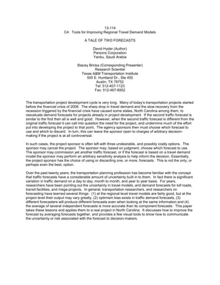
1. 13-114
C4: Tools for Improving Regional Travel Demand Models
A TALE OF TWO FORECASTS
David Hyder (Author)
Parsons Corporation
Yanbu, Saudi Arabia
Stacey Bricka (Corresponding Presenter)
Research Scientist
Texas A&M Transportation Institute
505 E. Huntland Dr., Ste 455
Austin, TX 78752
Tel: 512-407-1123
Fax: 512-467-8952
The transportation project development cycle is very long. Many of today’s transportation projects started
before the financial crisis of 2008. The sharp drop in travel demand and the slow recovery from the
recession triggered by the financial crisis have caused some states, North Carolina among them, to
reevaluate demand forecasts for projects already in project development. If the second traffic forecast is
similar to the first then all is well and good. However, when the second traffic forecast is different from the
original traffic forecast it can call into question the need for the project, and undermine much of the effort
put into developing the project to that point. The agency sponsors then must choose which forecast to
use and which to discard. In turn, this can leave the sponsor open to charges of arbitrary decision-
making if the project is at all controversial.
In such cases, the project sponsor is often left with three undesirable, and possibly costly options. The
sponsor may cancel the project. The sponsor may, based on judgment, choose which forecast to use.
The sponsor may commission yet another traffic forecast, or if the forecast is based on a travel demand
model the sponsor may perform an arbitrary sensitivity analysis to help inform the decision. Essentially,
the project sponsor has the choice of using or discarding one, or more, forecasts. This is not the only, or
perhaps even the best, option.
Over the past twenty years, the transportation planning profession has become familiar with the concept
that traffic forecasts have a considerable amount of uncertainty built in to them. In fact there is significant
variation in traffic demand on a day to day, month to month, and year to year basis. For years,
researchers have been pointing out the uncertainty in travel models, and demand forecasts for toll roads,
transit facilities, and mega-projects. In general, transportation researchers, and researchers on
forecasting have learned several things: (1) at the regional level travel models are fairly good, but at the
project level their output may vary greatly, (2) optimism bias exists in traffic demand forecasts, (3)
different forecasters will produce different forecasts even when looking at the same information and (4)
the average of several independent forecasts is more accurate than its component forecasts. This paper
takes these lessons and applies them to a real project in North Carolina. It discusses how to improve the
forecast by averaging forecasts together, and provides a few visual tools to show how to communicate
the uncertainty or risk associated with the forecast to decision-makers.
2. Hyder
Page no. 2
A TALE OF TWO FORECASTS
INTRODUCTION
NCDOT’s project R-2568C is intended to relieve congestion and improve safety on NC 109 between I-40,
on the north end of the project and Old Greensboro Road (SR 1756) to the south. FHWA and NCDOT
issued the Draft Environmental Impact Statement (EIS) on the project on September 7, 2010 (NCDOT-
PDEA, 2010). The traffic forecast in the Draft EIS estimated that traffic along the NC 109 corridor would
grow at 2.4% per year. The result was the determination that traffic would double by 2035, and thus, to
accommodate the expected traffic a much improved NC 109 would be needed. In 2012, NCDOT
reviewed and revised the project traffic forecast. The new traffic forecast estimates that traffic will grow at
0.9% per year, which will double traffic on NC 109 around 2090. If the revised traffic forecast is the better
estimate of future conditions a much different roadway is needed.
Figure 1: Map of Study Area and NC 109 Alternatives
Source: http://www.journalnow.com/news/local/nc-dot-selects-route-for-new-stretch-of-n-
c/article_0e5a627f-66b5-5a33-bd5e-afe05a9ead64.html?mode=image&photo=0
Historically, it was assumed that the traffic forecast was a good predictor of the demand for a facility
twenty or thirty years in the future. However, beginning in the 1990’s researchers began to question this
assumption. These researchers began by comparing demand forecasts for fixed guideway transit
systems (Pickerel) and toll roads (Flyvberg) with traffic counts shortly after opening. Bain found that, for
toll roads, the actual volume was approximately 77% of the forecasted volume with a standard deviation
of 26%. Although this is based on opening year forecasts, in further research he found that this
relationship holds for the life to the project. Specifically, he believes that the error in the design year may
be ±40%. Other research has shown that opening volumes on ‘free’ facilities area approximately 91% of
forecasted base year volume (Bent Flyvberg, Nils Bruzelius, Werner Rothengatter, 2003).
This paper documents the use of averages to overcome disparate traffic volume forecasts, in an effort to
inform the NC 109 project as well as provide an example that others in a similar situation may find useful.
The analysis includes an evaluation of traffic growth along NC 109, a statistical evaluation of the traffic
forecasts, an estimation of the range of traffic volumes on the selected alternatives, and an assessment
of the probability of traffic volumes exceeding capacity for a two-lane arterial.
The results conform to current literature, which indicates that traffic forecasts are subject to high levels of
error, and that as the geography for the traffic forecast gets smaller, the error increases. A
3. Hyder
Page no. 3
recommendation is made that each project have at least two independently developed traffic forecasts.
These forecasts should use the same base and horizon years, but should be separated by several years
and should be performed by different staff or different contractors.
REVIEW EXISTING CONDITIONS
Between 2003 and 2011 traffic along the section of NC 109 included in this project had growth rates
below 1% per year and in four of six count locations traffic fell, as shown in Figure 1. The red bars on
Figure 1 show locations where traffic fell between 2003 and 2011. The whiskers show the highest and
lowest traffic count between 2003 and 2011. The 2011 count is posted on the graph. Traffic fell at either
end of the project but grew between Wallburg Road and Gumtree Road.
Figure 2: Study Area Traffic Counts
ANALYTIC APPROACH
There are two traffic forecasts for this project that appear to conflict with one another: the Draft EIS
forecast of 2.4% growth per annum (2010) and the 2012 revised NCDOT forecast of 0.9% growth per
annum. Given that the two traffic forecasts were developed using good professional practice, they can be
used to better understand what is likely to happen in the region, using the Central Limit Theorem of
statistics. The central limit theorem helps in two ways. First, it allows the combination of the two traffic
forecasts into average forecast. Second, it allows an estimation of the error in the average forecast (Frey,
2006). Since there are two traffic estimates for every road in the traffic forecast, this is accomplished
through taking the average of each forecast value. Getting the likely error is a little harder and uses the
following formula:
or in English, the error is the standard deviation of the sample divided by the square root of the number of
samples.
I-40 - Teague
Road
Union Cross
Road - Gumtree
Road
Gumtree Road -
Motsinger Road
Motsinger Road
- Wallburg Road
Shady Grove
Church Road -
Johnson Road
Jesse Green
Road - Old
Greensboro
Road
2003 17,0009,8007,7008,8008,2007,400
Highest ADT 17000100008600940088008100
Lowest ADT 1600096007200760076006600
2011 16,0009,7008,0009,2008,0007,200
16,000
9,700
8,000
9,200
8,0007,200
6,000
7,000
8,000
9,000
10,000
11,000
12,000
13,000
14,000
15,000
16,000
17,000
ADT
NC 109 Traffic Changes (2003 - 2011)
To Thomasville Wallburg To Winston-Salem
4. Hyder
Page no. 4
Assuming that the forecast is optimistic and that the standard deviation of a forecast is 26% (Bain, 2011)
of the forecasted value it is possible to estimate a range of likely volumes for NC 109 using the following
formula:
Where z is the number of standard deviations away from the mean a forecast is, δ is the standard
deviation, and E is 91% of the forecast value for that section of roadway.
AVERAGING THE TWO FORECASTS
Alternative 1 (Improve Existing)
Figure 3 shows the average forecasted traffic on each section of existing NC 109 for 2035 along with the
95 percent confidence interval for the forecasts. Based on the two traffic forecasts, if NCDOT does not
undertake other improvements traffic on the north end of the project will be near 23,000 vehicles per day
while traffic on the south end of the project will be near 13,000 vehicles per day. Using a 9% design
hourly volume and a 60% directional split (Paul S. Schroeder, 2013) the peak period traffic near I-40 will
be around 1200 vehicles per hour and while the peak period traffic at the south end of the project will be
around 700 vehicles per hour. Using an hourly vehicle capacity of 1000 vehicles per hour and assuming
that hourly volume should be below 80% of capacity much of NC 109 needs improvement and the section
of NC 109 between I-40 and Gumtree Road is a bottleneck that badly needs more capacity.
Figure 3: Forecasted Traffic on Existing NC 109 Showing Forecast Error
The next step is to estimate the traffic variability. The results of this step are shown in Table 1. The
values in the body of the table show possible daily travel demand along NC 109 and how often demand
will be above that level. The cells are color coded: blue cells show low demand and red cells have
higher demand. For example, the lowest demand shown is 4000 vehicles per day between Old
Greensboro Road and Jesse Green Road while the highest demand shown is 35,000 vehicles per day
23,000
21,000
18,000
15,000 15,000 16,000 15,000 14,000 14,000 13,000 13,000
5,000
10,000
15,000
20,000
25,000
30,000
No Build Alternative
Lower Bound of Forecast Average Forecast Upper Bound of Forecast
5. Hyder
Page no. 5
between Teague Road and I-40. Cells to the left of the heavy black line have hourly volumes below 800
vehicles per hour. Cells to the right of the black line have hourly volumes over 800 vehicles per hour.
The middle column of Table 1 shows the most likely travel demand on any given day in 2035. In the
middle column of the table only the section of NC 109 between I-40 and Gumtree Road have traffic
volumes over 800 vehicles per hour. However there is a good chance that the rest of NC 109 will be
congested for many days during a year.
Alternative 6 (Recommendation from the DEIS)
Figure 4 shows the average forecasted traffic on each section of Alternative 6 and the 95 percent
confidence interval for the forecasts. Much of Alternative 6 is on a different alignment than NC 109 and
the expected demand in the middle of the project reflects the new location. Using a 9% design hourly
volume and a 60% directional split (Paul S. Schroeder, 2013) the peak period traffic near I-40 will be
around 1600 vehicles per hour, and while the peak period traffic at the south end of the project will be
around 700 vehicles per hour. Using an hourly vehicle capacity of 1000 vehicles per hour and assuming
that hourly volume should be below 80% of capacity much of NC 109 needs improvement and the section
of NC 109 between I-40 and Gumtree Road is a bottleneck that badly needs more capacity.
Figure 4: Forecasted Traffic on Alternative 6 Showing Forecast Error
29,000
15,000 15,000 14,000 15,000
12,000 12,000 11,000
8,000
6,000
19,000
0
5,000
10,000
15,000
20,000
25,000
30,000
35,000
40,000
Alternative 6-Recommded
Lower Limit of Forecast Average Forecast Upper Limit of Forecast
6. Hyder
Page no. 6
Table 2 shows the expected demand distribution for Alternative 6 based on both traffic forecasts. The
values in the body of the table show possible daily travel demand on Alternative 6. The cells are color
coded: blue cells show low demand and red cells show higher demand. The lowest demand shown, for
this alternative, is 2,000 vehicles per day between Jesse Green Road and Shady Grove Church Road.
The highest volume shown is 44,000 vehicle per day between I-40 and Teague Road. Cells to the left of
the two heavy black lines in Table 2 are expected to have volumes less than 800 vehicles per hour.
Furthermore several sections of Alternative 6 are likely to have excess capacity until the design year.
FINDINGS
Based on current literature, traffic forecasts are subject to high levels of error.
As the geography of the traffic forecast gets smaller the error gets larger (Bain, 2011).
Having two independent traffic forecasts available improves our ability to make recommendations
for the project. Averaging them provides a better position for planning purposes.
Most of NC 109 needs to be improved, and the north end of the project needs additional capacity.
There has been little growth in travel demand along NC 109 since 2003.
RECOMMENDATIONS
Each project should have at least two independently developed traffic forecasts. These forecasts should
use the same base and horizon years, but should be separated by several years and should be
performed by different staff or different contractors. Forecasting requires high levels of expertise and
judgment. Traffic forecasters should receive training in good forecasting methodology and statistical
analysis.
In addition, state Departments of Transportation should embark upon research, state specific research to
assess the error and variability of traffic forecasts over time for various types of transportation projects.
The author believes that in our current funding climate that it will be beneficial to better understanding of
the errors and accuracy of traffic forecasts and how traffic forecasts compare with volumes on different
types of projects.
References
Bain, R. (2011, April 5). On the reasonableness of traffic forecasts. Traffic Engineering and Control, 52(5),
213-217. Retrieved July 9, 2013, from RB Consult:
http://www.robbain.com/TEC%20Bain%20Final.pdf
Bent Flyvberg, Nils Bruzelius, Werner Rothengatter. (2003). Megaprojects and Risk: An Anatomy of
Amibtion. Cambridge, UK: Cambridge University Press.
NCDOT-PDEA. (2010). Administrative Action Draft Environmental Impact Statement NC 109
Improvements Study. NCDOT, Program Develoopment Branch. Raleigh: NCDOT.
Paul S. Schroeder, PhD. PE. (2013, February 8). Traffic Forecast fore R-2568C. Raleigh, NC, USA:
NCDOT.
7. Table 1: Expected Demand Distribution for the No Build Case
Probability of Demand Above the Table Value 99% 90% 84% 50% 16% 10% 1%
# of Days/Year with higher demand 361 329 307 183 58 37 4
Z Value -2.33 -1.39 -1.00 0.00 1.00 1.39 2.33
% of Average Forecast 30.4% 54.9% 65.0% 91.0% 117.0% 127.1% 151.6%
NC 109 Segment Estimated Daily Traffic
I-40 - Teague Road 7,000 13,000 15,000 21,000 27,000 29,000 35,000
Teague Road - Union Cross Road 6,000 11,000 13,000 19,000 24,000 26,000 31,000
Union Cross Road - Gumtree Road 5,000 10,000 12,000 16,000 21,000 23,000 27,000
Gumtree Road - Motsinger Road 5,000 8,000 10,000 14,000 18,000 19,000 23,000
Motsinger Road - Wallburg Road 5,000 8,000 10,000 14,000 18,000 20,000 23,000
Wallburg Road - Georgetown Road 5,000 9,000 10,000 14,000 18,000 20,000 24,000
Georgetown Road - Wallburg-High Point Road 5,000 8,000 10,000 14,000 18,000 20,000 23,000
Wallburg-High Point Road - Shady Grove Church
Road
4,000 8,000 9,000 13,000 17,000 18,000 21,000
Shady Grove Church Road - Johnson Road 4,000 8,000 9,000 13,000 17,000 18,000 22,000
Johnson Road - Jesse Green Road 4,000 7,000 8,000 12,000 15,000 17,000 20,000
Jesse Green Road - Old Greensboro Road 4,000 7,000 9,000 12,000 16,000 17,000 20,000
8. Hyder
Page no. 8
Table 2: Expected Demand Distribution for Alternative 6
Probability of Demand Above the Table Value 99% 90% 84% 50% 16.00% 10% 1%
# of Days/Year with higher demand 361 329 307 183 58 37 4
Z Value -2.33 -1.39 -1.00 0.00 1.00 1.39 2.33
% of Average Forecast 30.4% 54.9% 65.0% 91.0% 117.0% 127.1% 151.6%
NC 109 Section Estimated Daily Traffic
I-40 - Teague Road 9,000 16,000 19,000 27,000 34,000 37,000 44,000
Teague Road - Union Cross Road 5,000 8,000 10,000 14,000 18,000 19,000 23,000
Union Cross Road - Gumtree Road 5,000 8,000 10,000 14,000 18,000 19,000 23,000
Gumtree Road - Motsinger Road 4,000 8,000 9,000 12,000 16,000 17,000 21,000
Motsinger Road - Wallburg Road 4,000 8,000 10,000 13,000 17,000 19,000 22,000
Wallburg Road - Georgetown Road 4,000 7,000 8,000 11,000 14,000 15,000 18,000
Georgetown Road - Wallburg-High Point Road 4,000 7,000 8,000 11,000 14,000 15,000 18,000
Wallburg-High Point Road - Shady Grove Church
Road
3,000 6,000 7,000 10,000 13,000 14,000 17,000
Shady Grove Church Road - Johnson Road 2,000 4,000 5,000 7,000 9,000 10,000 11,000
Johnson Road - Jesse Green Road 2,000 3,000 4,000 5,000 7,000 7,000 8,000
Jesse Green Road - Old Greensboro Road 6,000 10,000 12,000 17,000 22,000 24,000 29,000
9. Hyder
Page no. 9
Additional Tables
The following tables show additional analysis that support the information shown in the body of the report.
Table 3: Hourly Demand for No Build 2035 Based Assuming 9% Peak and 60 % Directional Split
Probability of Demand Above the Table Value 99% 90% 84% 50% 16% 10% 1%
# of Days/Year with higher Demand 361 329 307 183 58 37 4
Z Value -2.33 -1.39 -1.00 0.00 1.00 1.39 2.33
% of Forecast Value 30.4% 54.9% 65.0% 91.0% 117.0% 127.1% 151.6%
NC 109 Segment Estimated Hourly Traffic Demand
I-40 - Teague Road 378 702 810 1134 1458 1566 1890
Teague Road - Union Cross Road 324 594 702 1026 1296 1404 1674
Union Cross Road - Gumtree Road 270 540 648 864 1134 1242 1458
Gumtree Road - Motsinger Road 270 432 540 756 972 1026 1242
Motsinger Road - Wallburg Road 270 432 540 756 972 1080 1242
Wallburg Road - Georgetown Road 270 486 540 756 972 1080 1296
Georgetown Road - Wallburg-High Point
Road
270 432 540 756 972 1080 1242
Wallburg-High Point Road - Shady Grove
Church Road
216 432 486 702 918 972 1134
Shady Grove Church Road - Johnson Road 216 432 486 702 918 972 1188
Johnson Road - Jesse Green Road 216 378 432 648 810 918 1080
Jesse Green Road - Old Greensboro Road 216 378 486 648 864 918 1080
10. Hyder
Page no. 10
Table 4: No Build 2035 Hourly Volume as a Percent of 1000 Vehicles per Hour
Probability of Demand Above the Table Value 99% 90% 84% 50% 16% 10% 1%
# of Days/Year with higher Demand 361 329 307 183 58 37 4
Z Value -2.33 -1.39 -1.00 0.00 1.00 1.39 2.33
% of Forecast Value 30.4% 54.9% 65.0% 91.0% 117.0% 127.1% 151.6%
NC 109 Segment Percent of 1000 VPH
I-40 - Teague Road 37.8% 70.2% 81.0% 113.4% 145.8% 156.6% 189.0%
Teague Road - Union Cross Road 32.4% 59.4% 70.2% 102.6% 129.6% 140.4% 167.4%
Union Cross Road - Gumtree Road 27.0% 54.0% 64.8% 86.4% 113.4% 124.2% 145.8%
Gumtree Road - Motsinger Road 27.0% 43.2% 54.0% 75.6% 97.2% 102.6% 124.2%
Motsinger Road - Wallburg Road 27.0% 43.2% 54.0% 75.6% 97.2% 108.0% 124.2%
Wallburg Road - Georgetown Road 27.0% 48.6% 54.0% 75.6% 97.2% 108.0% 129.6%
Georgetown Road - Wallburg-High Point
Road
27.0% 43.2% 54.0% 75.6% 97.2% 108.0% 124.2%
Wallburg-High Point Road - Shady Grove
Church Road
21.6% 43.2% 48.6% 70.2% 91.8% 97.2% 113.4%
Shady Grove Church Road - Johnson Road 21.6% 43.2% 48.6% 70.2% 91.8% 97.2% 118.8%
Johnson Road - Jesse Green Road 21.6% 37.8% 43.2% 64.8% 81.0% 91.8% 108.0%
Jesse Green Road - Old Greensboro Road 21.6% 37.8% 48.6% 64.8% 86.4% 91.8% 108.0%
11. Hyder
Page no. 11
Table 5: Hourly Demand for Alternative 6 2035 Based Assuming 9% Peak and 60 % Directional Split
Probability of Demand Above the Table Value 99% 90% 84% 50% 16.00% 10% 1%
# of Days/Year with Higher Demand 361 329 307 183 58 37 4
Z Value -2.33 -1.39 -1.00 0.00 1.00 1.39 2.33
% of Forecast Value 30.4% 54.9% 65.0% 91.0% 117.0% 127.1% 151.6%
NC 109 Section Estimated Hourly Traffic Demand
I-40 - Teague Road 486 864 1026 1458 1836 1998 2376
Teague Road - Union Cross Road 270 432 540 756 972 1026 1242
Union Cross Road - Gumtree Road 270 432 540 756 972 1026 1242
Gumtree Road - Motsinger Road 216 432 486 648 864 918 1134
Motsinger Road - Wallburg Road 216 432 540 702 918 1026 1188
Wallburg Road - Georgetown Road 216 378 432 594 756 810 972
Georgetown Road - Wallburg-High Point Road 216 378 432 594 756 810 972
Wallburg-High Point Road - Shady Grove Church Road 162 324 378 540 702 756 918
Shady Grove Church Road - Johnson Road 108 216 270 378 486 540 594
Johnson Road - Jesse Green Road 108 162 216 270 378 378 432
Jesse Green Road - Old Greensboro Road 324 540 648 918 1188 1296 1566
12. Hyder
Page no. 12
Table 6: Alternative 6 2035 Hourly Volume as a Percent of 1000 Vehicles per Hour
Probability of Demand Above the Table Value 99% 90% 84% 50% 16.00% 10% 1%
# of Days/Year with Higher Demand 361 329 307 183 58 37 4
Z Value -2.33 -1.39 -1.00 0.00 1.00 1.39 2.33
% of Forecast Value 30.4% 54.9% 65.0% 91.0% 117.0% 127.1% 151.6%
NC 109 Section Percent of 1000 VPH
I-40 - Teague Road 48.6% 86.4% 102.6% 145.8% 183.6% 199.8% 237.6%
Teague Road - Union Cross Road 27.0% 43.2% 54.0% 75.6% 97.2% 102.6% 124.2%
Union Cross Road - Gumtree Road 27.0% 43.2% 54.0% 75.6% 97.2% 102.6% 124.2%
Gumtree Road - Motsinger Road 21.6% 43.2% 48.6% 64.8% 86.4% 91.8% 113.4%
Motsinger Road - Wallburg Road 21.6% 43.2% 54.0% 70.2% 91.8% 102.6% 118.8%
Wallburg Road - Georgetown Road 21.6% 37.8% 43.2% 59.4% 75.6% 81.0% 97.2%
Georgetown Road - Wallburg-High Point Road 21.6% 37.8% 43.2% 59.4% 75.6% 81.0% 97.2%
Wallburg-High Point Road - Shady Grove Church
Road
16.2% 32.4% 37.8% 54.0% 70.2% 75.6% 91.8%
Shady Grove Church Road - Johnson Road 10.8% 21.6% 27.0% 37.8% 48.6% 54.0% 59.4%
Johnson Road - Jesse Green Road 10.8% 16.2% 21.6% 27.0% 37.8% 37.8% 43.2%
Jesse Green Road - Old Greensboro Road 32.4% 54.0% 64.8% 91.8% 118.8% 129.6% 156.6%