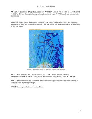
Download to read offline
![HLY1202 Cruise Report
74
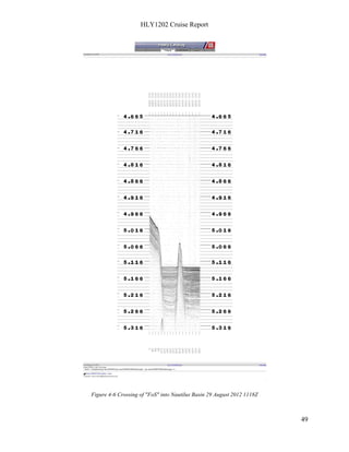
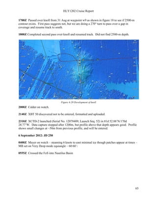
0000Z XBT launched (T-7, Serial No. 01118645, Launch No. 93) in 80d 49.79’N/162d
32.24’W. Converted with salinity from XCTD-3 Launch No. 28. Added 0032Z.
0005Z Moved back into thin ice, and port side swath dropped out again; moved to heavier ice
and the swath recovered. More evidence to suggest that the problem being observed is
being driven primarily by the ice type.
0400Z Mayer on watch – steaming west at about 10 knots – MBES set on manual mode
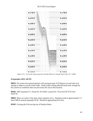
equiangular 60 60 Very DEEP
0800Z XBT taken - XBT launched (T-7, Serial No. 01053466, Launch No. 95) in 80d
31.48242N/170d 11.63477W. Converted with salinity from XCTD-3 Launch No. 28.
1105Z At end point of line running west – switching over to all AUTO settings on MB as we are
ice free. Will take XCTD-3 after turn is complete.
1135Z XCTD taken – XCTD-3 , Serial No. 11074183, Launch No. 97) in 80d 19.70459N/173d
13.54883W. Good cast – Steve will enter
1152Z XCTD-C3-00097 entered for SVP
1200Z Armstrong on watch
1620Z XBT T7_00099 s/n 01118653 dropped successfully and entered with salinity from
XCTD 00028.
2000Z Calder on watch.
2050Z Bridge requested a track deviation to assist in staging wind-flow across the flight deck;
requested that they slow down in order to minimize deviation during subsequent events.
2100Z [Mayer] Photo on the hanger deck – Davey Jones and crew visited and took WOGS away
– what will become of them we do not know.
2252Z Spotted ice ahead; slowing to 6 kts.
12 September 2012: JD 256
0005Z XBT launched (T-7, Serial No. 01118606, Launch No. 101) in 80d 23.48’N/160d
45.61’W. Small deviation from track (mainly in heading) due to ice push while slowed
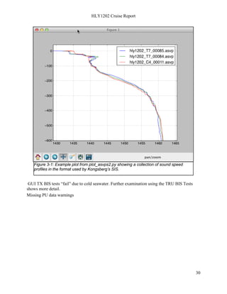
to allow for stable launch.
0050Z Flow through TSG feeding sound speed to the MBES stopped; switched to manual sound
speed while troubleshooting the cause.
0105Z Back to sensor source on MBES since TSG is recovered from an O2 sensor failure.](https://image.slidesharecdn.com/healy1202finalcruisereport-140714124836-phpapp02/85/U-S-Law-of-the-Sea-Cruise-to-Map-and-Sample-the-US-Arctic-Ocean-Margin-74-320.jpg)
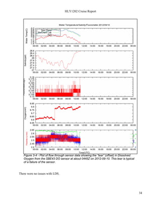
![HLY1202 Cruise Report
128
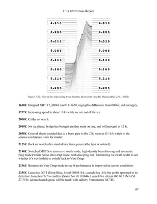
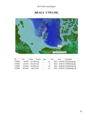
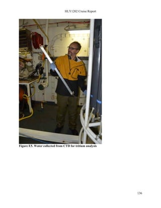
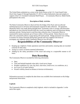
During the 5-week (August 26-September 27, 2011) UNCLOS (United Nations Convention
Law of the Sea) cruise on the US Coast Guard Cutter Healy (Co-Chief Scientists: Larry Mayer
and Andrew Armstrong), discrete and continuous underway water samples were collected
and when possible, analyzed onboard, to document the carbonate chemistry of the waters
in the Nautilus Basin, and Chukchi Cap areas (Figure 1). These data are being used to test
the waters’ saturation state with respect to calcium carbonate, with additional data to
identify processes that drive changes in saturation state. These data are critical to refine
existing models, which fail because of lack of baseline data.
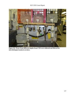
Discrete water samples
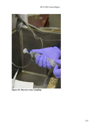
Discrete water samples were collected while underway following protocols outlined in
Dickson and others (2007). Surface water samples were collected for measurement of pH,
alkalinity, total alkalinity/total carbon, nutrients (NH4, Silica, PO4, and NO2+N), stable
carbon and oxygen isotopic composition, major elemental analysis, dissolved organic
carbon (DOC) and particulate organic carbon (POC). Discrete water samples were removed
from the sampling port of the vessel's flow-through seawater system in the main
laboratory (Figure 2).
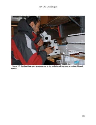
More than 625 pH and 614 alkalinity discrete samples were measured underway.
Discrete samples were collected aboard the Healy and those that were either analyzed or
were stored for analyses back onshore. These include: pH, alkalinity, CO3-2, nutrients, δ18O
isotope, δ13C isotope, metals, DOC, POC, DIC/Alkalinity.
Every hour, pH and alkalinity samples were taken and analyzed shipboard. Generally,
when the ship was traveling at a slower speed 4- 7 knots, the rest of the samples were
taken every 3-4 hours. When the ship traveled faster (~12kn), the suite of samples were
taken every 4 hours. Particulate organic carbon samples were collected twice daily.
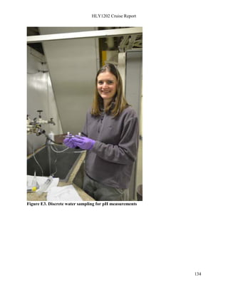
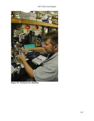
Shipboard pH and [CO32-] Analyses
Approximately 30 mL of seawater were collected directly into cylindrical optical glass cells
for pHT measurements on the total hydrogen ion scale following the procedure of SOP6b
(Dickson and others, 2007) (Figure 3). Cuvettes were then placed into an aluminum cell
warmer attached to a water bath at 25°C for approximately 20-30 minutes. Shipboard pH
measurements were performed using an Agilent 8453 spectrophotometer, purified
metacresol purple indicator dye, and equations modified by Liu and Byrne (in press).
Measurement of carbonate ion concentration was performed using an Agilent 8453
spectrophotometer, and methods of Byrne and Yao (2008). Figure 4 shows set up of both
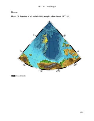
spectrophotometers. Figure 1 shows location of pH and alkalinity samples that were
measured.
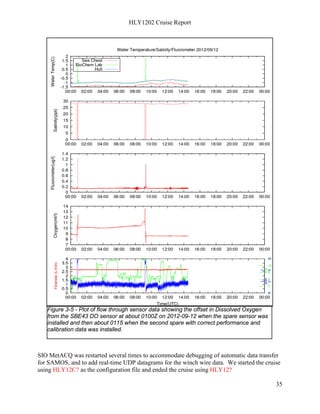
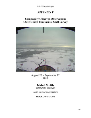
Underway Continuous Measurements
Approximately 4000 continuous measurements of pH, and TCO2 were performed between
August 27, 2012 to September 1, 2012 using a flow-through Multiparameter Inorganic
Carbon Analyzer (MICA) (Figure 5) and Seabird SBE49 CTD attached to the flow-through
system of the USCGC Healy. Geographic, salinity, temperature, and fluorometric data were](https://image.slidesharecdn.com/healy1202finalcruisereport-140714124836-phpapp02/85/U-S-Law-of-the-Sea-Cruise-to-Map-and-Sample-the-US-Arctic-Ocean-Margin-128-320.jpg)

This document summarizes the HEALY 1202 cruise report. The cruise took place from August 25 to September 27, 2012, mapping the US Arctic Ocean margin to support claims to an extended continental shelf under international law. Previous HEALY cruises since 2003 had similarly mapped the region. This cruise mapped over 29,000 km2 of seafloor using multibeam sonar and collected other geophysical data. The data helps define the outer limits of the US continental shelf and sediment thickness as required by the UN Convention on the Law of the Sea.


![Unit 4[1]](https://cdn.slidesharecdn.com/ss_thumbnails/unit41-120525191354-phpapp02-thumbnail.jpg?width=640&height=640&fit=bounds)


