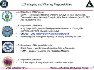
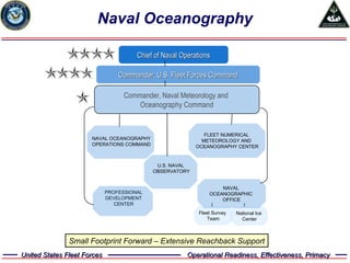
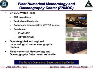
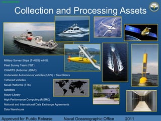
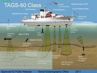
Unclassified Approved for Public Release Eric L. Villalobos Naval Meteorology and Oceanography  Command Overview Naval Oceanography Program Uniting the World through Oceanography
U.S. Mapping and Charting Responsibilities U.S. Department of Commerce  NOAA – Hydrography/National Shoreline surveys for legal boundaries, Tides and Currents, Nautical Charts for U.S. Territorial waters (to U.S. EEZ 200 nautical mile limit) U.S. Department of Defense Army Corps of Engineers – Dredging and maintenance of navigable channels and inland navigable waterways  CNMOC – OHB Military Surveys international waters Nat’l Geospatial Intelligence Agency – Charting Authority for DoD  U.S. Department of Homeland Security Coast Guard – Maintenance of maritime Aids to Navigation FEMA – Disaster Response and Floodplain Mapping U.S. Department of Interior U.S. Geological Survey – Interior to coastline base maps
Naval Oceanography Commander, U.S. Fleet Forces Command Chief of Naval Operations Commander, Naval Meteorology and  Oceanography Command Small Footprint Forward – Extensive Reachback Support NAVAL OCEANOGRAPHY OPERATIONS COMMAND U.S. NAVAL OBSERVATORY FLEET NUMERICAL  METEOROLOGY AND  OCEANOGRAPHY CENTER PROFESSIONAL DEVELOPMENT CENTER NAVAL  OCEANOGRAPHIC  OFFICE Fleet Survey  Team National Ice  Center
Fleet Numerical Meteorology and Oceanography Center (FNMOC) CNMOC Watch Floor 24/7 operations  Central reachback site Coordinate time-sensitive METOC support Data fusion PLANNING OPERATIONS Operate global and regional meteorological and oceanographic models Fleet Numerical Meteorology and Oceanography Detachment Asheville The Navy’s Operational Supercomputing Center
U.S. Naval Observatory (USNO) Precise Time Official DoD Time Fundamental to operations Precise Geolocation and Time (x,y,z,t) Astrometry Navigation Earth Orientation GPS Constellation Astronomical Applications  Navigation: Nautical, Air Almanacs High-Precision Applications: Astronomical Almanac
Naval Oceanographic Office 6   2  9  761   778  Officers   Chiefs   Junior Enlisted   Civilians Total
Core Competencies Approved for Public Release  Naval Oceanographic Office  2011 HYDROGRAPHY BATHYMETRY GEOPHYSICS ACOUSTICS PHYSICAL OCEANOGRAPHY REMOTE SENSING
Collection and Processing Assets Approved for Public Release  Naval Oceanographic Office  2011 Military Survey Ships (T-AGS) w/HSL Fleet Survey Team (FST) CHARTS (Airborne LIDAR) Underwater Autonomous Vehicles (UUV)  / Sea Gliders Tethered Vehicles Naval Platforms (TTS) Satellites  Maury Library High Performance Computing (MSRC) National and International Data Exchange Agreements Data Warehouse
TAGS-60 Class Approved for Public Release  Naval Oceanographic Office  2011 Length: 329 ft (100 m) Beam: 58 ft (18m) Draft 19 ft (6 m) Endurance: 12,000nmi@12knt:  Displacement: 5000 tons (4535 metric tons) Measurement  Buoy Seismic Profiling Magnetic Intensity Regulated Power System Data Processing Vertical Reference Acoustic Release System Satellite Navigation (GPS) UNCLASSIFIED
Ocean Gliders Approved for Public Release  Naval Oceanographic Office  2011 Weight 110 lb Hull Dia.  30 cm Length  2.8 m (w/1-m antenna) Horiz. Speed 0.6 knots  Max Depth 1000 m Theoretical - Endurance 6 months Range 4000 km Power  Lithium Comms  Iridium  Sensors Temp-Salinity-Optics In Situ Glider Data Ocean   Models
Approved for Public Release  Naval Oceanographic Office  2011 Regional Local Global Ocean Circulation Modeling Navy Layered Ocean Model (NLOM) Global Navy Coastal Ocean Model (NCOM) 3D full physics forecast models Shallow Water Analysis & Forecast System (SWAFS) East Asian Seas  NCOM Relocatable-NCOM High resolution 3D forecast models ADCIRC PC-Tides HydroMap RMA2 2D, rapidly placed coastal & estuary models
International Agreements For Data Exchange And Cooperative Surveys Approved for Public Release  Naval Oceanographic Office  2011 HONDURAS JAMAICA NICARAGUA PANAMA PERU TRINIDAD & TOBAGO VENEZUELA NORTHCOM CANADA MEXICO CENTCOM BAHRAIN PACOM AUSTRALIA INDONESIA MALAYSIA NEW ZEALAND PHILIPPINES SOUTH KOREA THAILAND SOUTHCOM BELIZE COLOMBIA COSTA RICA DOMINICAN REP. ECUADOR EL SALVADOR GUATEMALA EUCOM ALBANIA FRANCE GERMANY GREECE ICELAND ISRAEL MOROCCO PORTUGAL TUNISIA TURKEY UNITED KINGDOM
Strengthening Partnerships & Security Enhance Information Sharing & Interoperability DIMAR/CIOH Colombia Oceanographic SPS 2010
Strengthening Partnerships & Security Enhance Information Sharing & Interoperability Oceanographic SPS 2010 DHN/CHM Brazil
Strengthening Partnerships & Security Enhance Information Sharing & Interoperability Oceanographic SPS 2011 Chile
Strengthening Partnerships & Security Enhance Information Sharing & Interoperability Oceanographic SPS 2011 Peru

Oceanografía Naval Conjunta: Perú - EE.UU

  • 1.
    Unclassified Approved forPublic Release Eric L. Villalobos Naval Meteorology and Oceanography Command Overview Naval Oceanography Program Uniting the World through Oceanography
  • 2.
    U.S. Mapping andCharting Responsibilities U.S. Department of Commerce NOAA – Hydrography/National Shoreline surveys for legal boundaries, Tides and Currents, Nautical Charts for U.S. Territorial waters (to U.S. EEZ 200 nautical mile limit) U.S. Department of Defense Army Corps of Engineers – Dredging and maintenance of navigable channels and inland navigable waterways CNMOC – OHB Military Surveys international waters Nat’l Geospatial Intelligence Agency – Charting Authority for DoD U.S. Department of Homeland Security Coast Guard – Maintenance of maritime Aids to Navigation FEMA – Disaster Response and Floodplain Mapping U.S. Department of Interior U.S. Geological Survey – Interior to coastline base maps
  • 3.
    Naval Oceanography Commander,U.S. Fleet Forces Command Chief of Naval Operations Commander, Naval Meteorology and Oceanography Command Small Footprint Forward – Extensive Reachback Support NAVAL OCEANOGRAPHY OPERATIONS COMMAND U.S. NAVAL OBSERVATORY FLEET NUMERICAL METEOROLOGY AND OCEANOGRAPHY CENTER PROFESSIONAL DEVELOPMENT CENTER NAVAL OCEANOGRAPHIC OFFICE Fleet Survey Team National Ice Center
  • 4.
    Fleet Numerical Meteorologyand Oceanography Center (FNMOC) CNMOC Watch Floor 24/7 operations Central reachback site Coordinate time-sensitive METOC support Data fusion PLANNING OPERATIONS Operate global and regional meteorological and oceanographic models Fleet Numerical Meteorology and Oceanography Detachment Asheville The Navy’s Operational Supercomputing Center
  • 5.
    U.S. Naval Observatory(USNO) Precise Time Official DoD Time Fundamental to operations Precise Geolocation and Time (x,y,z,t) Astrometry Navigation Earth Orientation GPS Constellation Astronomical Applications Navigation: Nautical, Air Almanacs High-Precision Applications: Astronomical Almanac
  • 6.
    Naval Oceanographic Office6 2 9 761 778 Officers Chiefs Junior Enlisted Civilians Total
  • 7.
    Core Competencies Approvedfor Public Release Naval Oceanographic Office 2011 HYDROGRAPHY BATHYMETRY GEOPHYSICS ACOUSTICS PHYSICAL OCEANOGRAPHY REMOTE SENSING
  • 8.
    Collection and ProcessingAssets Approved for Public Release Naval Oceanographic Office 2011 Military Survey Ships (T-AGS) w/HSL Fleet Survey Team (FST) CHARTS (Airborne LIDAR) Underwater Autonomous Vehicles (UUV) / Sea Gliders Tethered Vehicles Naval Platforms (TTS) Satellites Maury Library High Performance Computing (MSRC) National and International Data Exchange Agreements Data Warehouse
  • 9.
    TAGS-60 Class Approvedfor Public Release Naval Oceanographic Office 2011 Length: 329 ft (100 m) Beam: 58 ft (18m) Draft 19 ft (6 m) Endurance: 12,000nmi@12knt: Displacement: 5000 tons (4535 metric tons) Measurement Buoy Seismic Profiling Magnetic Intensity Regulated Power System Data Processing Vertical Reference Acoustic Release System Satellite Navigation (GPS) UNCLASSIFIED
  • 10.
    Ocean Gliders Approvedfor Public Release Naval Oceanographic Office 2011 Weight 110 lb Hull Dia. 30 cm Length 2.8 m (w/1-m antenna) Horiz. Speed 0.6 knots Max Depth 1000 m Theoretical - Endurance 6 months Range 4000 km Power Lithium Comms Iridium Sensors Temp-Salinity-Optics In Situ Glider Data Ocean Models
  • 11.
    Approved for PublicRelease Naval Oceanographic Office 2011 Regional Local Global Ocean Circulation Modeling Navy Layered Ocean Model (NLOM) Global Navy Coastal Ocean Model (NCOM) 3D full physics forecast models Shallow Water Analysis & Forecast System (SWAFS) East Asian Seas NCOM Relocatable-NCOM High resolution 3D forecast models ADCIRC PC-Tides HydroMap RMA2 2D, rapidly placed coastal & estuary models
  • 12.
    International Agreements ForData Exchange And Cooperative Surveys Approved for Public Release Naval Oceanographic Office 2011 HONDURAS JAMAICA NICARAGUA PANAMA PERU TRINIDAD & TOBAGO VENEZUELA NORTHCOM CANADA MEXICO CENTCOM BAHRAIN PACOM AUSTRALIA INDONESIA MALAYSIA NEW ZEALAND PHILIPPINES SOUTH KOREA THAILAND SOUTHCOM BELIZE COLOMBIA COSTA RICA DOMINICAN REP. ECUADOR EL SALVADOR GUATEMALA EUCOM ALBANIA FRANCE GERMANY GREECE ICELAND ISRAEL MOROCCO PORTUGAL TUNISIA TURKEY UNITED KINGDOM
  • 13.
    Strengthening Partnerships &Security Enhance Information Sharing & Interoperability DIMAR/CIOH Colombia Oceanographic SPS 2010
  • 14.
    Strengthening Partnerships &Security Enhance Information Sharing & Interoperability Oceanographic SPS 2010 DHN/CHM Brazil
  • 15.
    Strengthening Partnerships &Security Enhance Information Sharing & Interoperability Oceanographic SPS 2011 Chile
  • 16.
    Strengthening Partnerships &Security Enhance Information Sharing & Interoperability Oceanographic SPS 2011 Peru