Downloaded 11 times
![The 21 st Century + Harvard Map ( + just in time) www.map.harvard.edu/mapserver/campusmap.htm ABCD-WWW December 9, 2009 Presented by Peter Siebert University Planning Office [email_address]](https://image.slidesharecdn.com/harvardmap-abcd-www-12-9-09-091210204709-phpapp01/85/The-21st-Century-Harvard-Map-1-320.jpg)
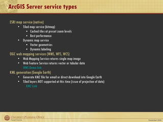
![Direct API calls Map Server URL: http://upo-srv2.cadm.harvard.edu/ArcGIS/rest/services Map Service URL: http:// < mapserver-url > / <svc name>/MapServer/ Export Map http:// < mapservice-url > /export Response format: f = html | json | image | kmz Bounding box: bbox = <xmin>, <ymin>, <xmax>, <ymax> Image size: size = <width>, <height> (default = 400x400) Image format: png | png8 | png24 | jpg | pdf | bmp | gif | svg | png32 DPI: dpi = <n> (default = 96) Set visible layers: layers = [show | hide | include | exclude]:layerId1,layerId2 Filter features by layer: layerDefs = layerId1:layerDef1;layerId2:layerDef2 example for Alternative Energy: layerDefs=0:TYPE=‘Solar’ Background transparency: transparent = true | false Img Spatial Ref (projection): imageSR = <wkid> (default = map projection) Bbox Spatial Ref: bboxSR = <wkid> Sample Export Request](https://image.slidesharecdn.com/harvardmap-abcd-www-12-9-09-091210204709-phpapp01/85/The-21st-Century-Harvard-Map-9-320.jpg)

The document discusses the development and technological aspects of web mapping services at Harvard, detailing various methods for displaying maps on webpages, including static images and interactive features. It highlights the transition from early web mapping techniques to advanced systems utilizing APIs and geospatial services, with a focus on user interactivity and data accessibility. Additionally, it outlines the Harvard map's evolution, including its current architecture and features supported by ArcGIS, Google Maps, and other mapping tools.