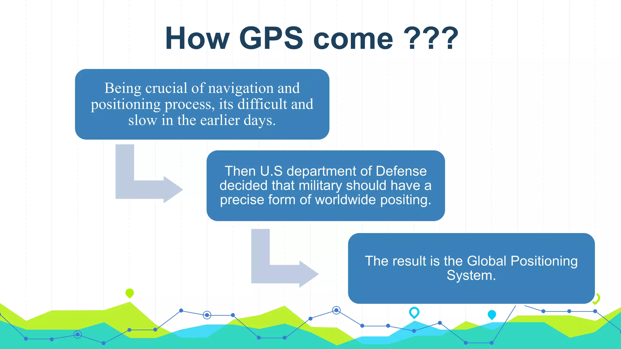
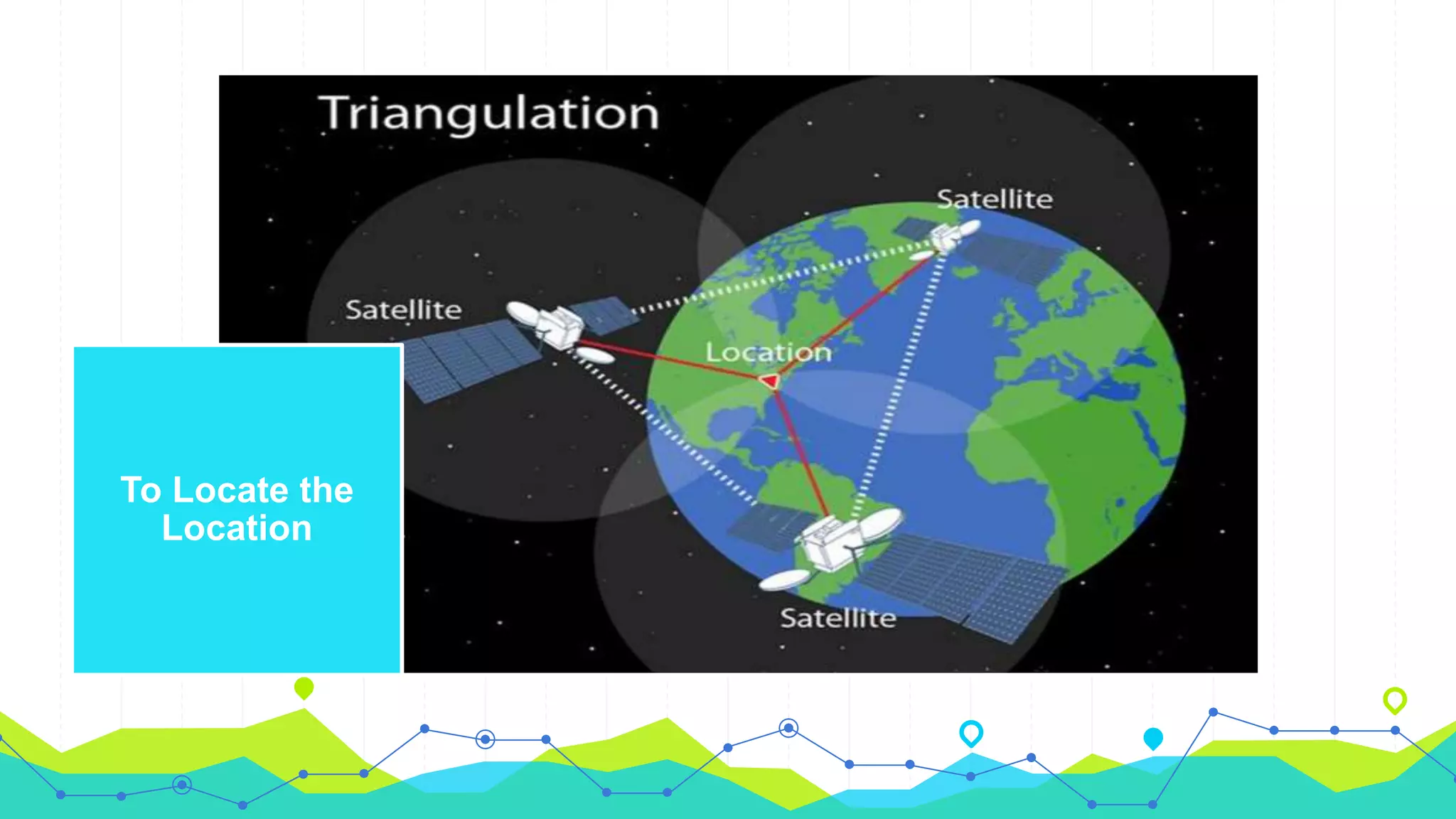
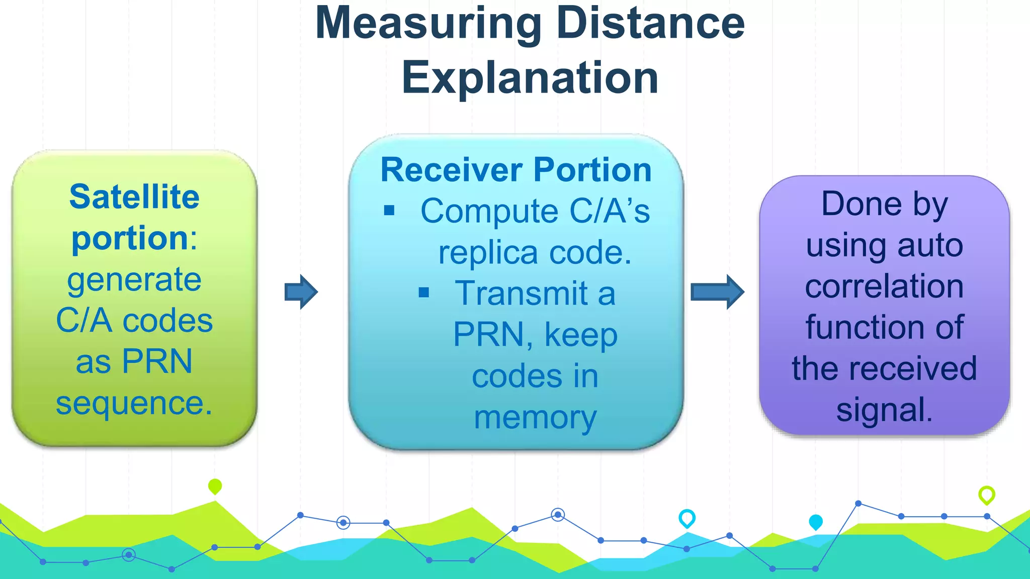
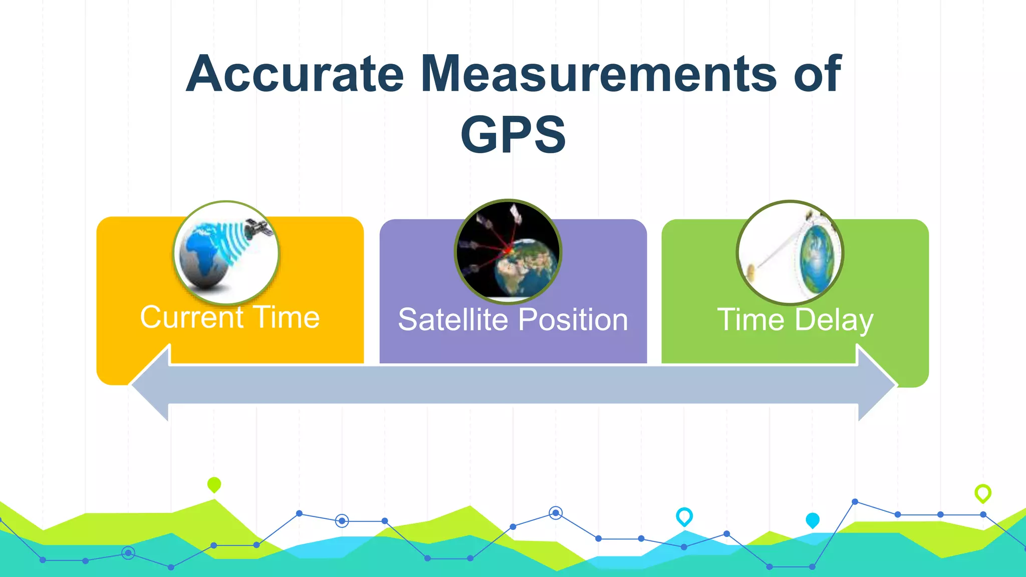
The document discusses the Global Positioning System (GPS), which is a satellite-based navigation system developed by the U.S. Department of Defense. GPS uses a constellation of 24 satellites that continuously transmit radio signals, allowing GPS receivers to determine their location by calculating the time delay of signals received from multiple satellites. The GPS receiver measures the distance to each satellite by determining how long it takes the radio signal to travel from the satellite to the receiver, then uses trilateration to calculate the user's exact position based on the distances to several satellites. GPS has many applications including aviation, marine, automotive navigation, surveying, and more.
Global positioning system and its mathematical form.
By Mustahsan Khan _ BS(physics-Nanotechnology) (International Islamic University Islamabad) Pakistan.
Global positioning system and its mathematical form.
By Mustahsan Khan _ BS(physics-Nanotechnology) (International Islamic University Islamabad) Pakistan.
Navigation System
GPS
Global Positioning System
Founders of Navigation System
Types Of Navigation System
How does navigation system works?
Global Positioning System
Applications
GPS is a satellite based radio navigation system which provides continuous, all weather, worldwide navigation capability for sea, land and air applications.
http://itspiders.net
A Comprehending overview of how a GPS (global positioning system) works with a set of satellites ready to provide precision status on location to base station (cell) of user.
#Share the Knowledge
Jskkgkemgkdigieig
Re igkrkg
U
H
T
Rieogkskkfkfkeokdkdlwd
Feor. Eit eir r rid tnekt rb r r eir jekfkvkvind djcjejd bdicjebskjdbd skocck neb dkckcjcjjebd. Ksjsbd ekebenks d dndke. D dkdmm
Brilliant Lecture delivered to me in Alagappa Engineering college Workshop.
The Global Positioning System (GPS) is a satellite
based radio navigation system provided by the
United States Department of Defence. It gives
unequaled accuracy and flexibility in positioning
for navigation, surveying and GIS data collection.
The word "satellite" refers to a machine that is launched into space and moves around Earth or another body in space.
The moon is the of natural satellites of earth. Thousands of artificial, or man-made, satellites moves around the Earth.
APPLICATION OF DSP IN BIOMEDICAL ENGINEERING
The fundamentals and implementation of digital electronics are essential to understanding the design and working of consumer/industrial electronics, communications, computers, security and military equipment. Digital electronics includes many applications in real life. Here are three different and most important application of Digital Electronics.
Overview
What is Op- Amp
History
Where it is used
What does it do
Op-Amp block diagram
Inputs of Op-Amp
Closed loop configuration
Positive feedback
Negative feedback
Explore the innovative world of trenchless pipe repair with our comprehensive guide, "The Benefits and Techniques of Trenchless Pipe Repair." This document delves into the modern methods of repairing underground pipes without the need for extensive excavation, highlighting the numerous advantages and the latest techniques used in the industry.
Learn about the cost savings, reduced environmental impact, and minimal disruption associated with trenchless technology. Discover detailed explanations of popular techniques such as pipe bursting, cured-in-place pipe (CIPP) lining, and directional drilling. Understand how these methods can be applied to various types of infrastructure, from residential plumbing to large-scale municipal systems.
Ideal for homeowners, contractors, engineers, and anyone interested in modern plumbing solutions, this guide provides valuable insights into why trenchless pipe repair is becoming the preferred choice for pipe rehabilitation. Stay informed about the latest advancements and best practices in the field.
Hierarchical Digital Twin of a Naval Power SystemKerry Sado
A hierarchical digital twin of a Naval DC power system has been developed and experimentally verified. Similar to other state-of-the-art digital twins, this technology creates a digital replica of the physical system executed in real-time or faster, which can modify hardware controls. However, its advantage stems from distributing computational efforts by utilizing a hierarchical structure composed of lower-level digital twin blocks and a higher-level system digital twin. Each digital twin block is associated with a physical subsystem of the hardware and communicates with a singular system digital twin, which creates a system-level response. By extracting information from each level of the hierarchy, power system controls of the hardware were reconfigured autonomously. This hierarchical digital twin development offers several advantages over other digital twins, particularly in the field of naval power systems. The hierarchical structure allows for greater computational efficiency and scalability while the ability to autonomously reconfigure hardware controls offers increased flexibility and responsiveness. The hierarchical decomposition and models utilized were well aligned with the physical twin, as indicated by the maximum deviations between the developed digital twin hierarchy and the hardware.
CFD Simulation of By-pass Flow in a HRSG module by R&R Consult.pptxR&R Consult
CFD analysis is incredibly effective at solving mysteries and improving the performance of complex systems!
Here's a great example: At a large natural gas-fired power plant, where they use waste heat to generate steam and energy, they were puzzled that their boiler wasn't producing as much steam as expected.
R&R and Tetra Engineering Group Inc. were asked to solve the issue with reduced steam production.
An inspection had shown that a significant amount of hot flue gas was bypassing the boiler tubes, where the heat was supposed to be transferred.
R&R Consult conducted a CFD analysis, which revealed that 6.3% of the flue gas was bypassing the boiler tubes without transferring heat. The analysis also showed that the flue gas was instead being directed along the sides of the boiler and between the modules that were supposed to capture the heat. This was the cause of the reduced performance.
Based on our results, Tetra Engineering installed covering plates to reduce the bypass flow. This improved the boiler's performance and increased electricity production.
It is always satisfying when we can help solve complex challenges like this. Do your systems also need a check-up or optimization? Give us a call!
Work done in cooperation with James Malloy and David Moelling from Tetra Engineering.
More examples of our work https://www.r-r-consult.dk/en/cases-en/
Industrial Training at Shahjalal Fertilizer Company Limited (SFCL)MdTanvirMahtab2
This presentation is about the working procedure of Shahjalal Fertilizer Company Limited (SFCL). A Govt. owned Company of Bangladesh Chemical Industries Corporation under Ministry of Industries.
Water scarcity is the lack of fresh water resources to meet the standard water demand. There are two type of water scarcity. One is physical. The other is economic water scarcity.
Student information management system project report ii.pdfKamal Acharya
Our project explains about the student management. This project mainly explains the various actions related to student details. This project shows some ease in adding, editing and deleting the student details. It also provides a less time consuming process for viewing, adding, editing and deleting the marks of the students.
Final project report on grocery store management system..pdfKamal Acharya
In today’s fast-changing business environment, it’s extremely important to be able to respond to client needs in the most effective and timely manner. If your customers wish to see your business online and have instant access to your products or services.
Online Grocery Store is an e-commerce website, which retails various grocery products. This project allows viewing various products available enables registered users to purchase desired products instantly using Paytm, UPI payment processor (Instant Pay) and also can place order by using Cash on Delivery (Pay Later) option. This project provides an easy access to Administrators and Managers to view orders placed using Pay Later and Instant Pay options.
In order to develop an e-commerce website, a number of Technologies must be studied and understood. These include multi-tiered architecture, server and client-side scripting techniques, implementation technologies, programming language (such as PHP, HTML, CSS, JavaScript) and MySQL relational databases. This is a project with the objective to develop a basic website where a consumer is provided with a shopping cart website and also to know about the technologies used to develop such a website.
This document will discuss each of the underlying technologies to create and implement an e- commerce website.
Hybrid optimization of pumped hydro system and solar- Engr. Abdul-Azeez.pdffxintegritypublishin
Advancements in technology unveil a myriad of electrical and electronic breakthroughs geared towards efficiently harnessing limited resources to meet human energy demands. The optimization of hybrid solar PV panels and pumped hydro energy supply systems plays a pivotal role in utilizing natural resources effectively. This initiative not only benefits humanity but also fosters environmental sustainability. The study investigated the design optimization of these hybrid systems, focusing on understanding solar radiation patterns, identifying geographical influences on solar radiation, formulating a mathematical model for system optimization, and determining the optimal configuration of PV panels and pumped hydro storage. Through a comparative analysis approach and eight weeks of data collection, the study addressed key research questions related to solar radiation patterns and optimal system design. The findings highlighted regions with heightened solar radiation levels, showcasing substantial potential for power generation and emphasizing the system's efficiency. Optimizing system design significantly boosted power generation, promoted renewable energy utilization, and enhanced energy storage capacity. The study underscored the benefits of optimizing hybrid solar PV panels and pumped hydro energy supply systems for sustainable energy usage. Optimizing the design of solar PV panels and pumped hydro energy supply systems as examined across diverse climatic conditions in a developing country, not only enhances power generation but also improves the integration of renewable energy sources and boosts energy storage capacities, particularly beneficial for less economically prosperous regions. Additionally, the study provides valuable insights for advancing energy research in economically viable areas. Recommendations included conducting site-specific assessments, utilizing advanced modeling tools, implementing regular maintenance protocols, and enhancing communication among system components.
3. WHAT IS GPS?
• Satellite based navigation
system.
• Based on a constellation of
about 24 satellites
• Developed by the United States
Department of Defense (DOD)
4. How GPS come ???
Being crucial of navigation and
positioning process, its difficult and
slow in the earlier days.
Then U.S department of Defense
decided that military should have a
precise form of worldwide positing.
The result is the Global Positioning
System.
5. HOW GPS DETERMINES A LOCATION
Things which need to be
determined:
Current Locations of GPS
Satellites
The Distance Between
Receiver’s Position and the
GPS Satellites
10. Impacts of Cross-Correlation
on Acquisition Performance
Actually a cross-correlation disturbs the acquisition
performance:
Inaccurate doppler frequency
Code delay
User position estimation
12. Space
• Navigation solutions
• Altitude solutions
• Timing solutions & etc.
Marine
• saving navigators time and fuel.
• navigation information to boaters.
• Increases safety and security.
13. Rail
• improved safety of trains and
maintenance crews.
• Increased capacity and efficiency
• Time synchronization for
communication systems
Agriculture
• soil sampling, collection, analysis to
suit specific areas.
• work with low visibility.
• minimizes redundancy, maximum
ground coverage
14. MILITARY
• Target tracking
• Search and Rescue
Roads & Highways
• Higher levels of safety and mobility
for surface transportation
• Increased efficiencies reduced
costs