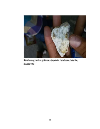
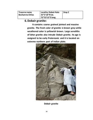
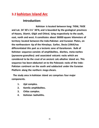
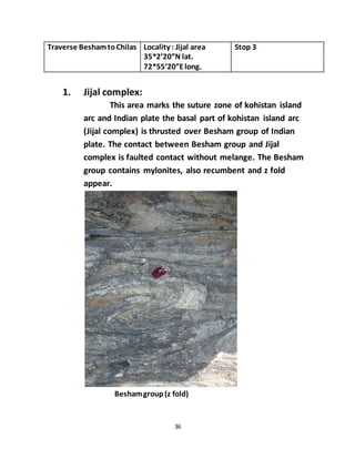
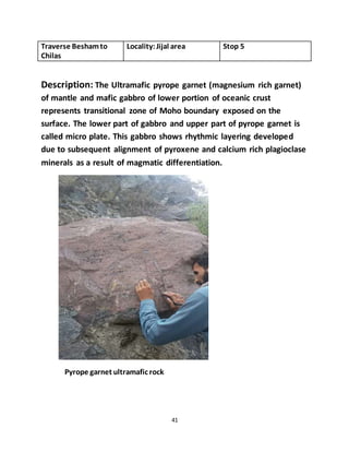
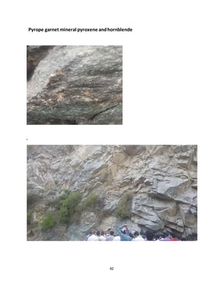
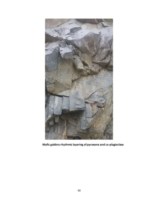
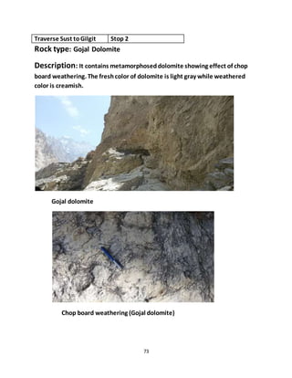
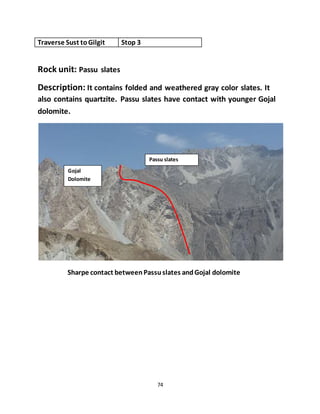
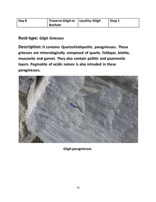
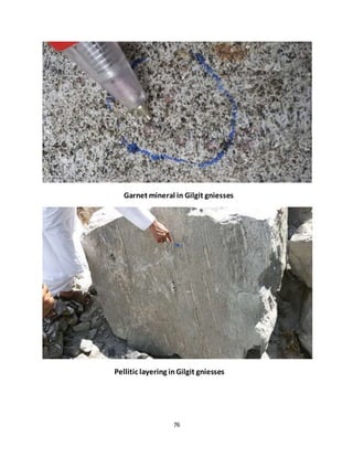
This geological field work report summarizes Haroon Ahmed's study of the Kohistan and Gilgit Baltistan area in northern Pakistan. The report describes the major geological features of the area, including the Indian plate, Kohistan island arc, and Eurasian plate. Key observations from the field work include descriptions of various rock types like granites, schists, and metavolcanics. The report also documents structural features like folds, faults, and the suture zones representing the collision of tectonic plates that formed the complex geology of the region.
Geology is the one of the most interesting subject about mother earth which can be best studied on field. This report of geological field work done at Chobhar area, Kathmandu consists observation with analysis regarding geological features, structures and processes.
Metallogenic Epoch and Province
Metallogenetic Epochs
Metallogenetic epochs, as defined above, are specific periods characterised by formation of large number of mineral deposits. It does not mean that all the mineral deposits formed during a definite metallogenetic epochs. In India the chief metallogenetic epochs were:
1. Precambrian
2. Late Palaeozoic
3. Late Mesozoic to Early Tertiary
CLASSIFICATION OF ORE DEPOSITS
The Mixture of ore minerals are gangue minerals form an Ore deposit. The ore
deposits are generally found enclosed within the country rocks. The ore deposits
are formed in many different ways. Depending upon the process that may
operate to produce them, the ore deposits may be classified as follow:
Magmatic ore deposits.
Sublimation ore deposits.
Pegmatitic ore deposits.
Contact metasomatic ore deposits.
Hydrothermal ore deposits
Cavity filling deposits.
Replacement deposits.
Sedimentation ore deposits.
Evaporation ore deposits.
Residual and mechanical concentration deposits
Metamorphic ore deposits.
MAGMATIC ORE DEPOSITS:
The magmatic ore deposits are the magmatic products which crystallize from
magmas. The magmatic ore deposits are classified as follows:
o Early magmatic deposits
o Late magmatic deposits
Early magmatic deposits:
Early magmatic deposits are formed during the
early stage of the magmatic period. In this case the
ore minerals crystallize earlier than the rock
silicates. The Minerals of Nickel, Chromium, and
Platinum are usually found as early magmatic
deposits. The early magmatic deposits can be sub
divided into two groups:
o Dissemination deposits
o Segregation deposits
Dissemination deposits:
When magma crystallizes
conditions, a granular igneous rock is formed. In
such a rock early formed crystals of
may occur in dissemination.
Segregation deposits:
Magmatic segregation deposits are
formed as a result of gravitative
crystallization differentiation. In
case, the ore mineral which crystallize
early, get ocean-trated on a particular
part of igneous part. The ore deposits
thus formed are known as “Segregation
deposits”.
rly under seated
ore minerals
such
Late Magmatic Deposits:
The ore deposits which are formed to
called late magmatic deposits. The late magmatic deposits contain those ore
minerals which have crystallized at rather low temperature from the residual
magma. The magma which is left after crystallization of early for
is called residual magma. This magma frequently contains many ore minerals. The
late magmatic deposits include most of the magmatic deposits of iron and
titanium ores, these deposits are almost always associated with mafic igneous
rocks.
SUBLIMATION DEPOSITS:
Sublimation is a very minor process of formation of ore deposits. Sublimation
deposits contain only those minerals which have been volatilized by hear and
subsequently redeposit in the same form at low temperature and pressure. The
sublimation deposits are found associated with Volcanoes and Fumaroles. Sulfur
of this origin has been mined in Japan, Italy, and Mexico.
MINERAL RESOURCE AND RESERVE DECLARATIONS AND ASSET MANAGEMENT; Resource Evaluation; Mineral Resource Asset Management; Inferred Mineral Resources; Indicated Mineral Resources; Measured Mineral Resources; Mineral reserves; Reserve definition; Feasibility study; GEOLOGIC CONDITIONS AND CHARACTERISTIC OF ORE DEPOSITS; MINE GEOLOGY RESPONSIBILITIES; Geological Database Configuration; Ore Control Process
Groundwater province is an area or region in which geology and climate combine to produce groundwater conditions consistent enough to permit useful generalisations.
Heavy Mineral Studies of Beach Sands of Vagathor, North Goa, IndiaIJMER
Vagator beach is situated 22 km away from panjim on the northern side Bardez taluk
approachable via Candolim are Mapusa by road. The beach is projected on both the sides by
promontories. The beach is in arcuate shape, the area included with survey of India toposheet No
48/E/14 which is bounded by latitudes 15º35ˈN 15º38ˈN and longitude 78º43ˈE. The Chapora river
and its tributaries drain the entire region that is the Vagator beach. It flows from North-East to
South-West direction. The drainage pattern is structurally controlled; the Chapora River has its
source in the Ramghat hills of Belgaum district in Karnataka then it flows through the Thilari ghat
and enters Goa. Its length in Goa is about 31 km and the mouth of the river bank, mud bank and
mangroves swamps are common.
In laboratory techniques heavy mineral separation are based mass separation in a liquid
with specific gravity and magnetic separation using hand magnet and Frantz isodynamic separator
at different volts. X-ray analysis was carried out by using RIGAKU ALTIMA IV copper target on the
basis of Bragg’s law. The non magnetic sand grains was observed under optical microscope to
identify diagnostic properties of minerals.
The heavy mineral shoot comprises of opaque (magnetite and illmenite) and transparent heavy
minerals like hornblende, epidote, garnet, rutile, zircon, enstatite and minor amounts of tourmaline.
The light minerals are mainly quartz and feldspars. The magnetite concentration ranges between 2.01
to 56.86% and Ilmenite between 2.83 to 41.04% and non mangnetics between 1.18 to 44.81%. X ray
diffraction studies and SEM (Scanning electron microscope) studies were employed to study the
mineralogical composition of beach sands of Vagator and detailed investigations are dealt in the
paper.
Five days field report of Gilgit Baltistan .
Started from Mansehra then Besham then Kohistan then Gilgit and at last stop is in Hunza.
Visited dasu and basha dam.
each and every feature realed to geology is marked in this field report.
Petroleum system, facies analysis and sedimentology of jurassic - cretaceous ...FatimaNasirQureshi
sedimentological differences of jurassic-cretaceous rocks in Hazara and Kohat Basin including their petrochemical analysis and depositional envoirnments
Synthetic Fiber Construction in lab .pptxPavel ( NSTU)
Synthetic fiber production is a fascinating and complex field that blends chemistry, engineering, and environmental science. By understanding these aspects, students can gain a comprehensive view of synthetic fiber production, its impact on society and the environment, and the potential for future innovations. Synthetic fibers play a crucial role in modern society, impacting various aspects of daily life, industry, and the environment. ynthetic fibers are integral to modern life, offering a range of benefits from cost-effectiveness and versatility to innovative applications and performance characteristics. While they pose environmental challenges, ongoing research and development aim to create more sustainable and eco-friendly alternatives. Understanding the importance of synthetic fibers helps in appreciating their role in the economy, industry, and daily life, while also emphasizing the need for sustainable practices and innovation.
Model Attribute Check Company Auto PropertyCeline George
In Odoo, the multi-company feature allows you to manage multiple companies within a single Odoo database instance. Each company can have its own configurations while still sharing common resources such as products, customers, and suppliers.
The Indian economy is classified into different sectors to simplify the analysis and understanding of economic activities. For Class 10, it's essential to grasp the sectors of the Indian economy, understand their characteristics, and recognize their importance. This guide will provide detailed notes on the Sectors of the Indian Economy Class 10, using specific long-tail keywords to enhance comprehension.
For more information, visit-www.vavaclasses.com
This is a presentation by Dada Robert in a Your Skill Boost masterclass organised by the Excellence Foundation for South Sudan (EFSS) on Saturday, the 25th and Sunday, the 26th of May 2024.
He discussed the concept of quality improvement, emphasizing its applicability to various aspects of life, including personal, project, and program improvements. He defined quality as doing the right thing at the right time in the right way to achieve the best possible results and discussed the concept of the "gap" between what we know and what we do, and how this gap represents the areas we need to improve. He explained the scientific approach to quality improvement, which involves systematic performance analysis, testing and learning, and implementing change ideas. He also highlighted the importance of client focus and a team approach to quality improvement.
The French Revolution, which began in 1789, was a period of radical social and political upheaval in France. It marked the decline of absolute monarchies, the rise of secular and democratic republics, and the eventual rise of Napoleon Bonaparte. This revolutionary period is crucial in understanding the transition from feudalism to modernity in Europe.
For more information, visit-www.vavaclasses.com
How to Split Bills in the Odoo 17 POS ModuleCeline George
Bills have a main role in point of sale procedure. It will help to track sales, handling payments and giving receipts to customers. Bill splitting also has an important role in POS. For example, If some friends come together for dinner and if they want to divide the bill then it is possible by POS bill splitting. This slide will show how to split bills in odoo 17 POS.
2024.06.01 Introducing a competency framework for languag learning materials ...Sandy Millin
http://sandymillin.wordpress.com/iateflwebinar2024
Published classroom materials form the basis of syllabuses, drive teacher professional development, and have a potentially huge influence on learners, teachers and education systems. All teachers also create their own materials, whether a few sentences on a blackboard, a highly-structured fully-realised online course, or anything in between. Despite this, the knowledge and skills needed to create effective language learning materials are rarely part of teacher training, and are mostly learnt by trial and error.
Knowledge and skills frameworks, generally called competency frameworks, for ELT teachers, trainers and managers have existed for a few years now. However, until I created one for my MA dissertation, there wasn’t one drawing together what we need to know and do to be able to effectively produce language learning materials.
This webinar will introduce you to my framework, highlighting the key competencies I identified from my research. It will also show how anybody involved in language teaching (any language, not just English!), teacher training, managing schools or developing language learning materials can benefit from using the framework.
Instructions for Submissions thorugh G- Classroom.pptxJheel Barad
This presentation provides a briefing on how to upload submissions and documents in Google Classroom. It was prepared as part of an orientation for new Sainik School in-service teacher trainees. As a training officer, my goal is to ensure that you are comfortable and proficient with this essential tool for managing assignments and fostering student engagement.
Palestine last event orientationfvgnh .pptxRaedMohamed3
An EFL lesson about the current events in Palestine. It is intended to be for intermediate students who wish to increase their listening skills through a short lesson in power point.
Home assignment II on Spectroscopy 2024 Answers.pdf
Geological field work report
1. 1
Geological Field Work Report
On
Kohistan and Gilgit Baltistan Area
Submitted By: Haroon Ahmed
Roll no: 20
Class: BS Applied Geology
Session: 2014-2018
Semester: 6th
Morning
Submitted to:
Institute Of Geology
University Of Azad Jammu And Kashmir
3. 3
Acknowledgements
First of all I pay my deepest thanks to Almighty
Allah who enabled me to complete this field work
report successfully.
I am greatly thankful to the Department of
Geology and professors (Dr. Mirza Shahid Beig and
Dr. Shabbier) for their utmost guidance and help.
These professors were the foundation bricks of
this fieldwork in terms of guidance for students
and through understanding of the field area.
This field work has been a memorable excursion
for me in the comprehension of enigmatic
theoretical knowledge. I once again pay my thanks
to my teachers who consider me able for achieving
my good goals
4. 4
Abstract
The study area, Gilgit and kohistan, is located the
Northern part of the Pakistan. The field area
extends along the Karakoram highway (KKH) and
Indus River. Geologically, the area is very complex
and highly deformed due to the collision zone and
triple junction of the world’s three largest
mountain series.
Geotectonically there are many large and
observable tectonics features in the area, main
suture zone, MMT, MKT, Triple junction, Kohistan
Island Arc, syntaxes collision zone of Indian and
Eurasian plates. Geomorphologically, the area
contains various alluvial fans, hot spring, mollase
deposits, and meandering streams.
The study area also contains various regional and
small scale folds, faults and fractures.
5. 5
SR# LIST OF CONTENT PAGE
NO.
1 INTODUCTION OF AREA 06
2 GEOLOGICAL MAP OF THE
AREA
07-09
3 FIELD DESCRIPTION
(TECTONICS AND ROCK TYPE)
INDIAN PLATE
KOSHIATAN ISLAND ARC
EURASIAN PLATE
10-83
4 GEOMORPHOLOGY 84-89
5 REFERENCES 90
6. 6
1: Introduction of Area
The field trip provides a geological cross-section in
Northern Pakistan from the margin of Indian plate to
hindu-kush terrine, through the kohistan island arc and
the Karakoram Range. Rocks exposed in this area are
mainly basalts, andesite sheets, and dominant volcanic
and igneous rocks and in some places there are Meta
sedimentary rocks. We studied different types of
igneous and metamorphic rocks which are highly
sheared and fractured.
Aims of study:
The geological field work report writing is an essential
requirement for BS degree in geology. The main
purposes of our field trip are:
Different rock identification.
Regional exposed geology of the area.
Practical work.
Mapping the area.
12. 12
3: Field description (tectonics and rock
type
Day 1 Station: Bararkot Stop 1
General overview of the area:
Area comprises of three main parts Indian Plate,
kohistan island arc, Eurasian plate or Karakoramblock.
It is the North Tertiary Metamorphism.
3.1 Indian plate
Indian plate includes some of the Northernregions of
Pakistan like parts of Hazara area and Besham. The
Hazara area includes rock units of Pre-Cambrian to
Cambrian age in Garhi habib-ullah, Bararkot and near
Mansehra. The Besham regioncomprises some
metamorphicfacie in Shangla and the oldestknown
rocks at Besham Basement Complex.
The geologicfieldstudy of North- western portionof
Indian plate is divided into two portions.
13. 13
Hazara region.
Besham and adjacent areas.
1.Hazara region:
The study areas in Hazara regionlies
near Brarkot, Garhi-habib-ullah, Batgram and
Mansehra. These rock formations have been
studied here;
Hazara formation.
Abbottabad formation.
Tanawal formation.
Mansehra Granite.
Hazara formation:
Hazara formation contains the oldest
low grade metamorphic rocks in lesser Himalayas.
It is composed mainly of shales, slate, and phyllite.
The fresh color of slates and phyllite is green to
dark green while weathered color is brown to dark
brown. The age of Hazara formation is assigned as
pre- Cambrian.
14. 14
Abbottabad formation:
It comprisestwo members i.e. Mumdagali
member and Sanghargali member.
The former is mainly composed of sandy dolomite
whereas the later consists of quartzite.
The chop-board weathering, formed due to
chemical solutioning of dolomite, has also been
observed in the formation. The age of Abbotabad
formation is Cambrian.
Sandy Dolomite
Mumdagali member
Traverse name :
Mzd to
Besham
Locality: Near
Garhi- habib-
ullah.
Stop 2
15. 15
Traverse MZD to
Besham
Locality:Across kahnar
River
Stop 3
Tanawal formation:
It is extended from Garhi-habib-ullah upto Thakot
Bridge. Tanawal formation is mainly composed of
pelitic and psammetic rocks (pelite are metamorphic
rock having argillaceous sedimentary protolith whereas
psammetic have arenaceous sedimentary protolith). It
contains medium to coarse grained garnet-mica schist,
metaquartizite and silty sandstone.
Different metamorphic grades of Tanawal formation
are described below:
Chlorite grade:
Chlorite grade schist shows low grade
metamorphism and the minerals are obscured to
both naked eye and under hand lens. Grade of
metamorphism increases towards collision zone
Chlorite grade schist lowgrade metamorphism
16. 16
Traverse MZD to
Besham
Locality: Stop 4
Biotite grade:
Biotite grade schist marks comparatively high
temperature and pressure metamorphic facie. Biotite
minerals are fine grained. Their presence only is found
by the appearance of shine under the hand lens. The
elongated quartz veins have been found due to
precipitation of residual silica.
Biotite gradeschist
18. 18
Traverse MZD to
Besham
Locality:SRSP Regional
office Mansehra
Stop 5
Mansehra Granite:
Mansehra granite is a plutonic igneous body formed
due to Pan- African orogeny. During Pan-African orogeny
magma accumulated in magma chamber and afterwards
solidified to form Mansehra granite. This granite is
composed of quartz, albite- oligoclase composition
plagioclase, orthoclase-microcline composition feldspar,
Muscovite and Biotite. Pegmatite intrusions have also
been reported from Mansehra granite. Phenocrysts have
also found forming “perforated texture”.
Mansehra granite intrudes into tanawal formation, age of
Mansehra granite Early- Paleocene. Age of tanawal
formation late Proterozoic
Mansehragranite intrude intanawal formation
20. 20
Traverse MZD to
Besham
Locality:Chatter plain
Darafarad
Stop 6
Garnet and Starolite grade:
The needle shape starolite mineral and
rounded garnet mineral has also been reported in
tanawal formation.Minerals Biotite and
muscovite are also found in the rock.
Garnet grade schist (New Shinkyari kotli pian)
Garnet starolite grade schist(Darafarad)
21. 21
Day 2 Traverse name:
Beshamto
Shangla
Locality:Besham Stop 1
2.Besham and adjacent areas:
The Besham area, located in the east of the Swat, and northwest
of the Hazara Divisions of the North West Frontier Province of
Pakistan, is bisected by the Indus River. It lies at the northern exposed
edge of the Indian plate where the MMT is embayed northward due
to major antiform in the footwall. There are three lithological groups
in Besham area: the Besharn Group, basement of biotitic gneisses and
schist; Pazang Group, metasediments as tectonic pods within the
basement gneisses; and the Karora Group, basal conglomerate
overlain by graphitic phyllites and micaceous quartzites.
The study units in this region are categorized as:
1. Besham basement complex,
2. Thakot formation.
3. Basement-cover relationship.
4. Shangla metavolcanics.
5. Besham Granite gniess.
6. Dobair granite.
22. 22
1.Besham basement complex:
Besham basement complex contains the oldest known rocks of
Pakistan. They include three types of rock fabrics showing multiple
phases of metamorphism, plutonism, and deformation. Their age
ranges from late Archean to middle Proterozoic. The development of
multiple fabrics shows the effect of at least one pre- Himalayan
orogeny and two Post Himalayan
The rocks are predominantly Quartzofeldspathic schist and gniess
(paragniesses). Dominant minerals are garnet, biotite, muscovite, and
quartz. Pegmatitic intrusions of lahor granite have also been observed
in the complex. These pegmatite have been formed the slow cooling
of residual magma and contain well-develop Biotite and Muscovite.
The age of lahor
granite is assigned as
Middle Proterozoic.
Quartzofeldspathic Besham complex
24. 24
Traverse Besham to
Shangla
Locality: Swat road near
Besham
Stop 2
1.Thakot formation:
Thakot formation represents the basal part of the
Besham complex. It comprises mainly of
Quartzofeldspathic, biotite gniess. The whole sequence is
psammetic with minor grayphitic schist. They contain
blue grey microcline.
25. 25
Traverse Beshamto
Shangla
Locality:Near Besham Stop 3
2.Basement- cover relationship:
Indian crustal plate consists of a crystalline basement
obscured by a complete succession of stratigraphic rock cover. The
basement lies thousand of meter below in subsurface. Surprisingly,
the basement is exposed on surface in Besham area and this is the
only area of its kind throughout the Indian plate where a basement-
cover relationship is conspicuous. The obvious basement- cover
context manifests a stark demonstration of the complex and vital
tectonic significance of the area.
The basement rock as described earlier consists of Quartzofeldspathic
schist and gniesses (paragniesses). A 25-30 meter thick conglomerate
matrix called Amlo Conglomerate separates basement rocks from the
cover rocks. The cover consists of rocks of Karora group.
Amlo-Conglomerate consists of rounded to sub rounded boulder,
pebble, cast of granite, schist and amphibolites
Amlo conglomerate have sharp contact with upper Karora group.
Karora group consists of graphitic phyllite and slates with
subordinate, fine grained, low grade marble. The fresh color of these
rocks is light grey to light creamish whereas their weathered color is
yellowish, brownish or dark greyish. The brown color shows staining
effect due to the presence of pyrite, magnetite and hematite.
26. 26
Karoragroup (grayphitic low grade M. Slates, phyllite)
Amlo conglomeratepolymitcong (unconformity)
Besham Group
Contact betweenpolymit conglomerate andKarora group (grayphitic slates)
Polymitconglomerate
27. 27
Cover sequence Marble at the top of Karora Group
Low grade Marble (Light grey, light creamish) part of Karora group
28. 28
Traverse
Besham to
Shangla
Locality: Alpuari
near Shangla
Stop 4
3.Shangla metavolcanics:
Rock type: Meta volcanic
Description; It contains sheared and brittle metavolcanic,
Ultramafic and basic rocks. It also contains hydrothermal
quartz veins. The highly sheared and fractured rock and a
discontinuous Stratigraphy shows presence of melange zone.
A regional scale fault called MMT (main mantle thrust) is
considered to pass through this area. Fresh color is greenish
and their weathered color reddish, yellowish.
Meta volcanic melange zone
29. 29
In the study area the major U.M rock is Dunite (altered into
serpentinite)
Serpentinite along melange zone
30. 30
Traverse
Besham to
Shangla
Locality: Shangla
top
Stop 5
4.Metamorphicfacie of shangle melange zone:
Description:
The typical Blue schist facie marks by the occurence of
needle shape glacophen mineral manifests the
development of the facie in trench zone. Blue schist facie
marks the high pressure and low temperature
environment. This trench zone shows the suture zone of
indo-pak crustal plate and kohistan island arc. Radiolaria
fossils have also been reported in the schist when observed
in thin section.
Blue schist facie
32. 32
Day 3 Traverse name :
Beshamto Chilas
Locality: Near
Besham
34*57’34”N lat.
72*52’16”Elong.
Stop 1
5.Besham granite gniess:
It consists of coarse grained, light yellow brown to
medium brown Meta igneous (orthogniesses) rock.
The weathered color is rusty brown while some
yellowish off-white patches show the staining effect.
The fresh color is light greyish to off-white. The major
minerals are quartz and feldspar while muscovite and
biotite are minor minerals. The rock beds are jointed
and fractured showing brittle deformation due o
stresses.
Besham granite gniesses
34. 34
Traverse name
Beshamto Chilas
Locality:Dobair Nala
35*2’18”N lat.
72*53’15”Elong.
Stop 2
6.Dobair granite:
It contains coarse grained jointed and massive
granite. The fresh color of granite is brown grey while
weathered color is yellowish brown. Large xenoliths
of lahor granite also intrude Dobair granite. Its age is
assigned to be early Proterozoic and it is located on
extreme northern part of Indian plate.
Dobair granite
35. 35
3.2 kohistan Island Arc
Introduction:
Kohistan is located between long: 7I0W, 76OE
and Lat. 34' 30's 3 6 ' 30'N, and is bounded by the geological provinces
of Hazara, Diamir, Gilgit and Chitral, lying respectively to the south,
east, north and west. It constitutes about 36000 square kilometers of
territory located between the Indo-Pakistan and Eurasian Plates, on
the northwestern tip of the Himalaya. Earlier, Desio (1964) has
differentiated this part as a tectonic zone of Kararkoram. Bulk of
Kohistan sequence consists of amphibolites, diorites, meta-norites
(pyroxene-granulites) and associated volcanic rocks which are
considered to be the crust of an ancient calc-alkaline island arc. This
sequence has been obducted on to the Paleozoic rocks of the Indo-
Pakistan continent on the south and subducted under the Eurasian
Platform along the northern mega shears.
The study area in kohistan island arc comprises four major
components.
1. Jijal complex.
2. Komila amphibolites.
3. Chilas complex.
4. Kohistan batholiths.
36. 36
Traverse BeshamtoChilas Locality : Jijal area
35*2’20”N lat.
72*55’20”Elong.
Stop 3
1. Jijal complex:
This area marks the suture zone of kohistan island
arc and Indian plate the basal part of kohistan island arc
(Jijal complex) is thrusted over Besham group of Indian
plate. The contact between Besham group and Jijal
complex is faulted contact without melange. The Besham
group contains mylonites, also recumbent and z fold
appear.
Beshamgroup(z fold)
38. 38
The basal part of kohistan island arc which is dunite (Ultramafic)
thrusted over the Besham group.
Dunite Ultramafic rock of Jijal complex
39. 39
Traverse Besham to
Chilas
Locality: Jijal area Stop 4
Description:
Major rock type of this area is pyroxenite (Ultramafic) rock.
It also contains mineral serpentine (olivine altered in serpentine) and
deposits of chromites.
U.M pyroxenite
Olivine alterationintoserpentine
41. 41
Traverse Beshamto
Chilas
Locality:Jijal area Stop 5
Description: The Ultramafic pyrope garnet (magnesium rich garnet)
of mantle and mafic gabbro of lower portion of oceanic crust
represents transitional zone of Moho boundary exposed on the
surface. The lower part of gabbro and upper part of pyrope garnet is
called micro plate. This gabbro shows rhythmic layering developed
due to subsequent alignment of pyroxene and calcium rich plagioclase
minerals as a result of magmatic differentiation.
Pyrope garnet ultramafic rock
44. 44
Traverse Beshamto
Chilas
Locality:near pattan
village
Stop 6
Rock type: Pattan gabbros
Description: It contains layered to massive gabbro with minor
garnet. Overall gabbro has massive behavior. Pattan gabbro also
intrudes in to Komila amphibolites. These two separated by pattan
fault which is active fault.
Pattan gabbros
45. 45
Traverse Beshamto
Chilas
Locality:near Komila
village
Stop 7
2. Komila amphibolites:
Description: It contains black color layered rock called Komila
amphibolites. The amphibolites are intruded by the roof pendants of
pattan gabbro. Amphibolites mineral (plagioclase and hornblende)
Roof pendants of pattan gabbros in Komila amphibolites
46. 46
Day 4 Traverse name:
Chilas to Gilgit
Locality:near
Chilas city
35*24’37”N lat.
74*8’47”Elong.
Stop 1
3. Chilas complex:
Description:
It contains one of the largest plutonic depositsinthe world. It
contains alternating Ultramafic andmafic which have beenformed by the
magmatic differentiation of basaltic magma. These rocks extendtoward
west.
Chilas gabbros are richin hornblende, plagioclase, orthopyroxeneand
clinopyroxene, gabbros alsocontains Serpentine mineral formeddue to
the alterationof olivine.
Sedimentary structureslike pot holes alsofoundin Chilas gabbros which
are formed due toriver flowand solutioning effect. This gabbrohas
normal and shearedcontact with ultramafic rock dunite.
Chilas gabbros (having pot hole)
47. 47
Gabbro and dunite sheared contact (Chilas)
Gabbro and dunite normal contact (Chilas)
49. 49
Traverse Chilas toGilgit Locality:Tatta pani Stop 6
Rock type: Orthogniesses.
Description: These orthogniesses are called Nanga Parbat gniess.
These rocks are sheared and fractured showing brittle deformation. It
also contains gouge, breccia, and mylonites texture which has been
deformed by brittle deformation. A seismically active fault called
Rahikot Fault separates these Nanga Parbat gniesses from Quaternary
Molasses deposit of kohistan island arc. The basement Nanga Parbat
gniesses thrust over quaternary fluvioglacial quaternary molasses
deposits.
Highly shearedorthogniesses (NangaParbat gniesses)
51. 51
Traverse Chilas toGilgit Locality:Rahikot bridge Stop 7
Rock type: Diorite.
Description: It contains quartz and feldspar rich Diorite. The
anorthocite content in the Diorite is less than 50%.
Diorite intermediate plutonic rock
52. 52
Traverse Chilas to
Gilgit
Locality:Chilas
complex
Stop 8
Rock unit: Thalichi formation
Description: It comprises low grade slates, quartzite, marbles
and grayphitic schist. These are Back-arc basin deposits. The
grayphitic schist contains chloritite needles with no garnet mineral
and it shows Tinolite. The age of formation is cretaceous.
Low grade slates of Thalichi formation
54. 54
Day 5 Traverse name:
Gilgit toSust
Locality:Gilgit
35*59”19”N lat.
74*19’36”Elong.
Stop 1
Rock unit: Denyor granite gniess
Description: It contains white or light color gniesses. Denyor granite
gniesses intrudes intoolder dark gray gniesses. Xenoliths of older gniesses are
highly metamorphosed.
Intrusive contact of Denyor grano-gniesses younger white color andolder dark
grey gniesses
Xenoliths of older gniesses in
Denyor grano-gniesses
55. 55
Traverse Gilgit toSust Locality:Near Gilgit Stop 2
Rock unit: Matamdass granite
Description: Matamdass granite is leucocratic and show sulphide
mineralization. It also contains quartz, feldspar, biotite, garnet specks
and epidote mineral occurring sparsely on granite surface it also
contains vesicles. The age of rock unit is cretaceous.
Matamdass granite (Fore Arc basin)
56. 56
Traverse Gilgit toSust Locality:juglot link Stop 3
4. Kohistan batholiths:
Rock type: Meta basalt
Description: This Meta basalt contains matrix and pillow lava
structures which are coarse grain at center and fine grain at
corners. It is mineralogically composed of chlorite, feldspar,
albite and actinolite.
Metabasalt contains matrix and pillowlava structures
57. 57
Traverse Gilgit toSust Locality:Near Gilgit
36*15’21”N lat.
74*12’18”Elong.
Stop 4
Description: This area contains highly sheared and fractured
metasediments and marks the MKT (Main Karakoram thrust) zone.
The rocks are mainly low grade slates and phylites. This region marks
the end portion of kohistan island arc and Passive Margin of Eurasian
plate. Baltit group of rocks is thrusting on kohistan island arc. Baltit
group is in turn intruded by quartzite and marble of kohistan
batholiths. In MKT zone also contain some low grade mafic rocks and
also some ultramafic rock.
Metasediments lowgrade slates phylites
END of KOHISTAN ISLAND ARC
59. 59
End of kohistanisland arc and start of Eurasianplate mark by M.K.T
3.3. Eurasian plate:
Passive margin of Eurasian plate: At the passive margin of
Eurasian plate it contains low grade slate, phylites and Biotite schist.
Low grade slates, phylites inpassive marginof Eurasianplate
Eurasian
plate
End kohistan
islandarc
61. 61
Traverse Gilgit toSust Locality:Hunza Bridge Stop 5
Rock unit: Baltit Group
Description: Baltit group contains metasediments like quartzite and
schist of late Paleozoic age. The quartzite and marble layers are
alternating with each other and belong to garnet grade. The Baltit
group is also intruded by karakoram batholiths of cretaceous age.
Baltit groupintrudedby karakoram batholiths
62. 62
Traverse Gilgit toSust Locality: Stop 6
Rock type: Meta sediments
Description: It contains starolite garnet grade rock. The starolite
grade is marked by the presence of biotite, garnet, starolite,
plagioclase and quartz minerals. The metasediments of this area are
formed by the metamorphism of the sediments belonging to passive
margin of Eurasian plate.
Starolite garnet grade rock inEurasian plate
63. 63
Traverse Gilgit toSust Locality: near Darkot Stop 7
Rock type: Darkot group
Description: It is mainly composed of white to off-white crystalline
marble. The marble has unusual sugery texture and is alternating with
dark layers of Amphibolites. It contains minerals of amphibole like
hornblende, plagioclase, and garnet. Graphitic layers and minerals
phlogophite, muscovite and pyrite are also present in these rocks.
Small specks of pinkish mineral called Ruby (gemstone) are also
present in the rock.
Darkot group bands of amphibolites andmarbles
64. 64
Off- white bands marble and dark layers amphibolites
Sugery texture marble (Darkot group)
66. 66
Traverse Gilgit toSust Locality:near Darkot
36*17’60”N lat.
74*47’17”Elong.
Stop 8
Rock unit: Darkot group
Description: It comprises folded bands of coarsely crystalline marble
alternating with dark color amphibolites.
Darkot group has faulted contact with Quartzofeldspathic gniesses.
Foldedbands of marble and amphibolites (Darkot group)
67. 67
Darkot group and Mylonites Quartzofeldspathic gniesses have a
faulted contact. Quartzofeldspathic gniesses also have leucocratic
veins.
Mylonites gniesses
Quartzofeldspathic gniesses
69. 69
Day 6 Traverse Sust to
Khunjarab
Locality: near Sust
36*47’46”N lat.
74*49’9”Elong.
Stop 1
Rock unit: kilik formation
Description: It contains metasediments, argillites, metasandstone,
quartzites, marble and low grade limestone and dolomite. The fresh
color of the rocks is creamish to medium gray while weathered color
is rusty brown. The formation is medium to thickly bed and contains
solutioning effect due to chemical weathering.
Kilik formation
71. 71
Traverse Sust to
Khunjarab
Locality: Khunjarab road
36*47’34”N lat.
74*55’44”Elong.
Stop 2
Rock type: Misker slates
Description: Low grade slates sograinsize fine. Dark grayishslates.
Masker slates showgreenschistfacie.
72. 72
Day 7 Traverse Sust
to Gilgit
Locality:near Sust
36*38’37”N lat.
74*51’1”Elong.
Stop 1
Rock unit: Gircha Dolomite. Description: It contains low
grade dolomite of carboniferous age. It intruded by mafic body
containing feldspar crystals hornblende actinolite and has porphyritic
texture.
GirchaDolomite
Igneous body intrudedinGircha dolomite
73. 73
Traverse Sust toGilgit Stop 2
Rock type: Gojal Dolomite
Description: It contains metamorphoseddolomite showing effect of chop
board weathering. The freshcolor of dolomite is light gray while weathered
color is creamish.
Gojal dolomite
Chop board weathering (Gojal dolomite)
74. 74
Traverse Sust toGilgit Stop 3
Rock unit: Passu slates
Description: It contains folded and weathered gray color slates. It
also contains quartzite. Passu slates have contact with younger Gojal
dolomite.
Sharpe contact betweenPassuslates andGojal dolomite
Passu slates
Gojal
Dolomite
75. 75
Day 8 Traverse Gilgit to
Besham
Locality:Gilgit Stop 1
Rock type: Gilgit Gniesses
Description: It contains Quartzofeldspathic paragniesses. These
gniesses are mineralogically composed of quartz, feldspar, biotite,
muscovite and garnet. They also contain pellitic and psammetic
layers. Pegmatite of acidic nature is also intruded in these
paragniesses.
Gilgit paragniesses
78. 78
Traverse Gilgit toBesham 35*51’30”N lat.
74*30’4”Elong.
Stop 2
Rock type: Meta Basalt
Description: These Meta basalts have intrusive contact with
gniesses. Meta basalts have minerals hornblende, pyroxene, and
biotite
Meta basalts
84. 84
Day 9 Traverse Besham
to Mansehra
Locality:Beshank
area
Stop 1
Rock type: Shank granite
Description: It contains light gray microcline feldspathic granite only
found in Beshank area. Beshank granite is a coarsely grain granite.
Shank granite
86. 86
4: Geomorphology
Kohistan is characterized by rugged terrain and high relief. The
mountains have a general east-west trend and vary in elevations from
2 00 metres in the south near its border with Hazara to over 5000
metres in the north in the vicinity of Diamir. The mountain peaks
show typical ice skittled sharp features with steep slopes, occasionally
covered by sparse alpine type vegetation. The Indus River is the major
drainage artery, whereas Ushw, Gabral and Kandia tributaries capture
the drainage of the western part of Kohistan.
The major valleys inhabit the larger part of the population of
Kohistan. The climatic conditions of these valleys are extreme; cold
winters and hot summers. The summer maximum temperature may
be above 110 OF and winter minima is below freezing point, The
annual rainfall is variable in the valleys and ranges from 30 to 65 cm.
Much of the precipitation is in the form of snow during winter.
Kohistan in sparsely vegetated
87. 87
Traverse: Chilas to Gilgit.
Locality: Chilas area
Description: The area contains significant geomorphic features like
composite terraces and fan deposits. They have been deposited by
river streams and nallas. A different size boulder in these deposits
represents braded stream deposits.
88. 88
Traverse: Chilas to Gilgit.
Locality: Jalipur (Chilas area)
Description: It contains fluviolacial deposits which have pebble
layers and massive boulders with no sorting.
89. 89
Traverse: Chilas to Gilgit
Description: It contains well developed river terrace along the river
Indus.
91. 91
Traverse: Gilgit to Chilas
Description: necking of river valley shows fault rejuvenation. The beds along
river have beentiltedopposite toriver.
Necking of valley marks fault
Quaternary and bed rock relationRahikot Fault
92. 92
5: References
Khan, R. A., TAHIR KHELI, Geology of
kohistan and adjoining Eurasian and
indo- Pakistan continents , Pakistan.
Khan, R. A., TAHIR KHELI, Geotectonic
Evolutionof, Pakistan.
GEOL. Bull. Univ. Peshawar, 1989,Vol.22,
pp.65-82.