SlideShare a Scribd company logo
GIS is a technological field that incorporates
geographical features with tabular data in
order to map, analyze, and assess real-world
problems.
Remote sensing is the process of detecting
and monitoring the physical characteristics of
an area by measuring its reflected and emitted
radiation at a distance (typically from satellite
or aircraft). Remote sensed imagery is
integrated within a GIS
Application of GIS
• Urban Planning
• Rural Planning
• Water
• Land Management
• Disaster Management
• Utility Mapping
• Navigation etc.
Application of GIS in Water Sector
Why ?
Using GIS through RS. RS :
• Allows rapid assessment of large areas, and
selection of subsets for detailed analyses
• Water has distinctive spectral properties; water
absorbs radiation – in infrared imagery, water
appears black
• Water quality can also be picked up from remote
sensing.
Application of GIS in Hydrology GIS Input for :
• River Basin Planning/ Modelling
• Command Area Management
• Storm Water Management Plan
• Flood Inundation Study
• Rainwater Harvesting and Artificial Recharge
• Flood Forecasting
• Disaster Early Warning
• Watershed Management
• Groundwater Assessment
• Water Quality Assessment
Mapping of Features for Planning through GIS
Application of GIS in Hydrology
• Catchment Delineation
• Extraction of Streams
• Delineation of
surface water bodies
Major GIS Input used in Hydrolgy :
• Basin & Sub basin (delineated from DEM), Streams, (captured through images or delineated
from DEM)
• Land-use/Land-cover Data
• Rainfall (spatial distribution through radar satellites)
• Soil moisture and its spatial distribution for estimation of crop water use and irrigation
requirement
• Reservoir water spread through multi-temporal images
• Spread of habitation in village/ urban sprawl over time (to assess growth of domestic and
municipal water demand over the past and prepare estimates for the future)
• Spread of industrial area to corroborate with information on growth pattern of industries, for
better estimation of future industrial water demand
• Estimation of snow water melt (through spatial coverage of snow bound area and
temperature)
Application of GIS in Water Utility
• Water Supply Design
• Sewerage Design
• Drainage Design
FOR:
• Development of hydraulic models,
• Creation of thematic maps of the model output results,
• Network simplification (skeletonization) for hydraulic modeling,
• Estimation of node demands, estimation of node elevations
Application of GIS in Watershed Management
• Terrain Modelling
• Creation of DEMs,
• Automated watershed extraction
from topography,
• Flow determination – direction and
accumulation ,
• Stream-ordering
Application of GIS in
Flood Management For
* Flood plain delineation
* Channel characteristics
* Inundation modeling
* Infrastructure analysis
* Risk modeling and mitigation
Application GIS in Groundwater Assessment:
• Remote sensing can be used to collect information about terrain geology
and geomorphology, crucial for estimation of groundwater potential
• Lineaments, cracks and fissures and their crossings that are extremely
useful for locating wells in hard rock terrain are seldom visible on
ground but easily demarcated on satellite images
Application of GIS in Irrigation Command Area management
• Estimation of crop acreage
• Crop production
• preparation of “irrigability maps” through land use planning.
Application GIS in Quality analysis of water :
• Satellite imageries have been used successfully in determination of
various water quality parameters like Total Suspended Solids,
turbidity, chlorophyll content, colour, temperature etc. By Remote
Sensing
• Use of GPS for location & photographic tiepoints
The latest RS technologies applied in Water Sector include:
• 3D surface model analysis
• Unmanned aerial vehicle (UAV) video image classification
• Ground penetration radar for soil moisture estimation
• The Tropical Rainfall Measuring Mission (TRMM) and the Global Precipitation
Measurement (GPM) satellite rainfall measurements
• Storm hyetography analysis
• Rainfall runoff and urban flooding simulation
• Satellite radar and optical image classification for urban water bodies and flooding
inundation.
The application of those technologies is expected to greatly relieve the pressures on water
resources and allow better mitigation of and adaptation to the disastrous impact of
droughts and flooding.
Thank You !

More Related Content

Similar to GIS-WaterSector (1).pptx

DIGITIZATION OF CITIES ON GIS PLATFORM.pdf
DIGITIZATION OF CITIES ON GIS PLATFORM.pdfDIGITIZATION OF CITIES ON GIS PLATFORM.pdf
DIGITIZATION OF CITIES ON GIS PLATFORM.pdf
HimanshuDeshmukh32
 
7 - AECOM Water Resources Seminar World Bank -16-Sept
7 - AECOM Water Resources Seminar World Bank -16-Sept7 - AECOM Water Resources Seminar World Bank -16-Sept
7 - AECOM Water Resources Seminar World Bank -16-Sept
indiawrm
 
Geospatial Applications in Civil Engineering
Geospatial Applications in Civil EngineeringGeospatial Applications in Civil Engineering
Geospatial Applications in Civil Engineering
Sriharsha Rangineni
 
lect 1-2.pdf
lect 1-2.pdflect 1-2.pdf
lect 1-2.pdf
AniruddhMane2
 
Ground water prospects map
Ground water prospects mapGround water prospects map
Ground water prospects map
Thupili Prem Sai Reddy
 
Development of Sonpari village Under the Scheme of Smart Village
Development of Sonpari village Under the Scheme of Smart VillageDevelopment of Sonpari village Under the Scheme of Smart Village
Development of Sonpari village Under the Scheme of Smart Village
Bhavik A Shah
 
Online Watershed Analysis Tool
Online Watershed Analysis Tool Online Watershed Analysis Tool
Online Watershed Analysis Tool
Malla Reddy University
 
gis.pdf
gis.pdfgis.pdf
gis.pdf
RaduPopa30
 
gis.pdf
gis.pdfgis.pdf
gis.pdf
RaduPopa30
 
A Intro LS PLF.pptx
A Intro LS PLF.pptxA Intro LS PLF.pptx
A Intro LS PLF.pptx
alex15509
 
Introduction of GIS & Remote Sensing (RS)
Introduction of GIS & Remote Sensing (RS)Introduction of GIS & Remote Sensing (RS)
Introduction of GIS & Remote Sensing (RS)
Subtain Hussain Syed
 
Geographic information system
Geographic information systemGeographic information system
Geographic information system
Sumanta Das
 
GISapplication.ppt
GISapplication.pptGISapplication.ppt
GISapplication.ppt
MOHNIKASAMINENI
 
Remote sensing and it's applications
Remote sensing and it's applicationsRemote sensing and it's applications
Remote sensing and it's applications
Waleed Liaqat
 
Role of GIS and remote sensing in Disaster Management
  Role of GIS and remote sensing in Disaster Management  Role of GIS and remote sensing in Disaster Management
Role of GIS and remote sensing in Disaster Management
Leema Margret A
 
Watershed development and drainage assessments
Watershed development and drainage assessmentsWatershed development and drainage assessments
Watershed development and drainage assessments
Andrew Harrison
 
Gis
GisGis
PIAS 2013-GIS.pptxfskjczjsbchdbfscnnND dHSA
PIAS 2013-GIS.pptxfskjczjsbchdbfscnnND  dHSAPIAS 2013-GIS.pptxfskjczjsbchdbfscnnND  dHSA
PIAS 2013-GIS.pptxfskjczjsbchdbfscnnND dHSA
FloridaTLaoaten
 
Appllications of Remote Sensing.ppt
Appllications of Remote Sensing.pptAppllications of Remote Sensing.ppt
Appllications of Remote Sensing.ppt
UjjwalSubedi8
 
RNK - GIS Brochure
RNK - GIS BrochureRNK - GIS Brochure
RNK - GIS Brochure
Ronak Ashar
 

Similar to GIS-WaterSector (1).pptx (20)

DIGITIZATION OF CITIES ON GIS PLATFORM.pdf
DIGITIZATION OF CITIES ON GIS PLATFORM.pdfDIGITIZATION OF CITIES ON GIS PLATFORM.pdf
DIGITIZATION OF CITIES ON GIS PLATFORM.pdf
 
7 - AECOM Water Resources Seminar World Bank -16-Sept
7 - AECOM Water Resources Seminar World Bank -16-Sept7 - AECOM Water Resources Seminar World Bank -16-Sept
7 - AECOM Water Resources Seminar World Bank -16-Sept
 
Geospatial Applications in Civil Engineering
Geospatial Applications in Civil EngineeringGeospatial Applications in Civil Engineering
Geospatial Applications in Civil Engineering
 
lect 1-2.pdf
lect 1-2.pdflect 1-2.pdf
lect 1-2.pdf
 
Ground water prospects map
Ground water prospects mapGround water prospects map
Ground water prospects map
 
Development of Sonpari village Under the Scheme of Smart Village
Development of Sonpari village Under the Scheme of Smart VillageDevelopment of Sonpari village Under the Scheme of Smart Village
Development of Sonpari village Under the Scheme of Smart Village
 
Online Watershed Analysis Tool
Online Watershed Analysis Tool Online Watershed Analysis Tool
Online Watershed Analysis Tool
 
gis.pdf
gis.pdfgis.pdf
gis.pdf
 
gis.pdf
gis.pdfgis.pdf
gis.pdf
 
A Intro LS PLF.pptx
A Intro LS PLF.pptxA Intro LS PLF.pptx
A Intro LS PLF.pptx
 
Introduction of GIS & Remote Sensing (RS)
Introduction of GIS & Remote Sensing (RS)Introduction of GIS & Remote Sensing (RS)
Introduction of GIS & Remote Sensing (RS)
 
Geographic information system
Geographic information systemGeographic information system
Geographic information system
 
GISapplication.ppt
GISapplication.pptGISapplication.ppt
GISapplication.ppt
 
Remote sensing and it's applications
Remote sensing and it's applicationsRemote sensing and it's applications
Remote sensing and it's applications
 
Role of GIS and remote sensing in Disaster Management
  Role of GIS and remote sensing in Disaster Management  Role of GIS and remote sensing in Disaster Management
Role of GIS and remote sensing in Disaster Management
 
Watershed development and drainage assessments
Watershed development and drainage assessmentsWatershed development and drainage assessments
Watershed development and drainage assessments
 
Gis
GisGis
Gis
 
PIAS 2013-GIS.pptxfskjczjsbchdbfscnnND dHSA
PIAS 2013-GIS.pptxfskjczjsbchdbfscnnND  dHSAPIAS 2013-GIS.pptxfskjczjsbchdbfscnnND  dHSA
PIAS 2013-GIS.pptxfskjczjsbchdbfscnnND dHSA
 
Appllications of Remote Sensing.ppt
Appllications of Remote Sensing.pptAppllications of Remote Sensing.ppt
Appllications of Remote Sensing.ppt
 
RNK - GIS Brochure
RNK - GIS BrochureRNK - GIS Brochure
RNK - GIS Brochure
 

Recently uploaded

Bossa N’ Roll Records by Ismael Vazquez.
Bossa N’ Roll Records by Ismael Vazquez.Bossa N’ Roll Records by Ismael Vazquez.
Bossa N’ Roll Records by Ismael Vazquez.
IsmaelVazquez38
 
A Free 200-Page eBook ~ Brain and Mind Exercise.pptx
A Free 200-Page eBook ~ Brain and Mind Exercise.pptxA Free 200-Page eBook ~ Brain and Mind Exercise.pptx
A Free 200-Page eBook ~ Brain and Mind Exercise.pptx
OH TEIK BIN
 
BÀI TẬP BỔ TRỢ TIẾNG ANH LỚP 8 - CẢ NĂM - FRIENDS PLUS - NĂM HỌC 2023-2024 (B...
BÀI TẬP BỔ TRỢ TIẾNG ANH LỚP 8 - CẢ NĂM - FRIENDS PLUS - NĂM HỌC 2023-2024 (B...BÀI TẬP BỔ TRỢ TIẾNG ANH LỚP 8 - CẢ NĂM - FRIENDS PLUS - NĂM HỌC 2023-2024 (B...
BÀI TẬP BỔ TRỢ TIẾNG ANH LỚP 8 - CẢ NĂM - FRIENDS PLUS - NĂM HỌC 2023-2024 (B...
Nguyen Thanh Tu Collection
 
REASIGNACION 2024 UGEL CHUPACA 2024 UGEL CHUPACA.pdf
REASIGNACION 2024 UGEL CHUPACA 2024 UGEL CHUPACA.pdfREASIGNACION 2024 UGEL CHUPACA 2024 UGEL CHUPACA.pdf
REASIGNACION 2024 UGEL CHUPACA 2024 UGEL CHUPACA.pdf
giancarloi8888
 
Bonku-Babus-Friend by Sathyajith Ray (9)
Bonku-Babus-Friend by Sathyajith Ray  (9)Bonku-Babus-Friend by Sathyajith Ray  (9)
Bonku-Babus-Friend by Sathyajith Ray (9)
nitinpv4ai
 
Accounting for Restricted Grants When and How To Record Properly
Accounting for Restricted Grants  When and How To Record ProperlyAccounting for Restricted Grants  When and How To Record Properly
Accounting for Restricted Grants When and How To Record Properly
TechSoup
 
Electric Fetus - Record Store Scavenger Hunt
Electric Fetus - Record Store Scavenger HuntElectric Fetus - Record Store Scavenger Hunt
Electric Fetus - Record Store Scavenger Hunt
RamseyBerglund
 
Observational Learning
Observational Learning Observational Learning
Observational Learning
sanamushtaq922
 
Data Structure using C by Dr. K Adisesha .ppsx
Data Structure using C by Dr. K Adisesha .ppsxData Structure using C by Dr. K Adisesha .ppsx
Data Structure using C by Dr. K Adisesha .ppsx
Prof. Dr. K. Adisesha
 
CHUYÊN ĐỀ ÔN TẬP VÀ PHÁT TRIỂN CÂU HỎI TRONG ĐỀ MINH HỌA THI TỐT NGHIỆP THPT ...
CHUYÊN ĐỀ ÔN TẬP VÀ PHÁT TRIỂN CÂU HỎI TRONG ĐỀ MINH HỌA THI TỐT NGHIỆP THPT ...CHUYÊN ĐỀ ÔN TẬP VÀ PHÁT TRIỂN CÂU HỎI TRONG ĐỀ MINH HỌA THI TỐT NGHIỆP THPT ...
CHUYÊN ĐỀ ÔN TẬP VÀ PHÁT TRIỂN CÂU HỎI TRONG ĐỀ MINH HỌA THI TỐT NGHIỆP THPT ...
Nguyen Thanh Tu Collection
 
Simple-Present-Tense xxxxxxxxxxxxxxxxxxx
Simple-Present-Tense xxxxxxxxxxxxxxxxxxxSimple-Present-Tense xxxxxxxxxxxxxxxxxxx
Simple-Present-Tense xxxxxxxxxxxxxxxxxxx
RandolphRadicy
 
Educational Technology in the Health Sciences
Educational Technology in the Health SciencesEducational Technology in the Health Sciences
Educational Technology in the Health Sciences
Iris Thiele Isip-Tan
 
220711130088 Sumi Basak Virtual University EPC 3.pptx
220711130088 Sumi Basak Virtual University EPC 3.pptx220711130088 Sumi Basak Virtual University EPC 3.pptx
220711130088 Sumi Basak Virtual University EPC 3.pptx
Kalna College
 
Elevate Your Nonprofit's Online Presence_ A Guide to Effective SEO Strategies...
Elevate Your Nonprofit's Online Presence_ A Guide to Effective SEO Strategies...Elevate Your Nonprofit's Online Presence_ A Guide to Effective SEO Strategies...
Elevate Your Nonprofit's Online Presence_ A Guide to Effective SEO Strategies...
TechSoup
 
Standardized tool for Intelligence test.
Standardized tool for Intelligence test.Standardized tool for Intelligence test.
Standardized tool for Intelligence test.
deepaannamalai16
 
THE SACRIFICE HOW PRO-PALESTINE PROTESTS STUDENTS ARE SACRIFICING TO CHANGE T...
THE SACRIFICE HOW PRO-PALESTINE PROTESTS STUDENTS ARE SACRIFICING TO CHANGE T...THE SACRIFICE HOW PRO-PALESTINE PROTESTS STUDENTS ARE SACRIFICING TO CHANGE T...
THE SACRIFICE HOW PRO-PALESTINE PROTESTS STUDENTS ARE SACRIFICING TO CHANGE T...
indexPub
 
How to Manage Reception Report in Odoo 17
How to Manage Reception Report in Odoo 17How to Manage Reception Report in Odoo 17
How to Manage Reception Report in Odoo 17
Celine George
 
Wound healing PPT
Wound healing PPTWound healing PPT
Wound healing PPT
Jyoti Chand
 
How to Fix [Errno 98] address already in use
How to Fix [Errno 98] address already in useHow to Fix [Errno 98] address already in use
How to Fix [Errno 98] address already in use
Celine George
 
BIOLOGY NATIONAL EXAMINATION COUNCIL (NECO) 2024 PRACTICAL MANUAL.pptx
BIOLOGY NATIONAL EXAMINATION COUNCIL (NECO) 2024 PRACTICAL MANUAL.pptxBIOLOGY NATIONAL EXAMINATION COUNCIL (NECO) 2024 PRACTICAL MANUAL.pptx
BIOLOGY NATIONAL EXAMINATION COUNCIL (NECO) 2024 PRACTICAL MANUAL.pptx
RidwanHassanYusuf
 

Recently uploaded (20)

Bossa N’ Roll Records by Ismael Vazquez.
Bossa N’ Roll Records by Ismael Vazquez.Bossa N’ Roll Records by Ismael Vazquez.
Bossa N’ Roll Records by Ismael Vazquez.
 
A Free 200-Page eBook ~ Brain and Mind Exercise.pptx
A Free 200-Page eBook ~ Brain and Mind Exercise.pptxA Free 200-Page eBook ~ Brain and Mind Exercise.pptx
A Free 200-Page eBook ~ Brain and Mind Exercise.pptx
 
BÀI TẬP BỔ TRỢ TIẾNG ANH LỚP 8 - CẢ NĂM - FRIENDS PLUS - NĂM HỌC 2023-2024 (B...
BÀI TẬP BỔ TRỢ TIẾNG ANH LỚP 8 - CẢ NĂM - FRIENDS PLUS - NĂM HỌC 2023-2024 (B...BÀI TẬP BỔ TRỢ TIẾNG ANH LỚP 8 - CẢ NĂM - FRIENDS PLUS - NĂM HỌC 2023-2024 (B...
BÀI TẬP BỔ TRỢ TIẾNG ANH LỚP 8 - CẢ NĂM - FRIENDS PLUS - NĂM HỌC 2023-2024 (B...
 
REASIGNACION 2024 UGEL CHUPACA 2024 UGEL CHUPACA.pdf
REASIGNACION 2024 UGEL CHUPACA 2024 UGEL CHUPACA.pdfREASIGNACION 2024 UGEL CHUPACA 2024 UGEL CHUPACA.pdf
REASIGNACION 2024 UGEL CHUPACA 2024 UGEL CHUPACA.pdf
 
Bonku-Babus-Friend by Sathyajith Ray (9)
Bonku-Babus-Friend by Sathyajith Ray  (9)Bonku-Babus-Friend by Sathyajith Ray  (9)
Bonku-Babus-Friend by Sathyajith Ray (9)
 
Accounting for Restricted Grants When and How To Record Properly
Accounting for Restricted Grants  When and How To Record ProperlyAccounting for Restricted Grants  When and How To Record Properly
Accounting for Restricted Grants When and How To Record Properly
 
Electric Fetus - Record Store Scavenger Hunt
Electric Fetus - Record Store Scavenger HuntElectric Fetus - Record Store Scavenger Hunt
Electric Fetus - Record Store Scavenger Hunt
 
Observational Learning
Observational Learning Observational Learning
Observational Learning
 
Data Structure using C by Dr. K Adisesha .ppsx
Data Structure using C by Dr. K Adisesha .ppsxData Structure using C by Dr. K Adisesha .ppsx
Data Structure using C by Dr. K Adisesha .ppsx
 
CHUYÊN ĐỀ ÔN TẬP VÀ PHÁT TRIỂN CÂU HỎI TRONG ĐỀ MINH HỌA THI TỐT NGHIỆP THPT ...
CHUYÊN ĐỀ ÔN TẬP VÀ PHÁT TRIỂN CÂU HỎI TRONG ĐỀ MINH HỌA THI TỐT NGHIỆP THPT ...CHUYÊN ĐỀ ÔN TẬP VÀ PHÁT TRIỂN CÂU HỎI TRONG ĐỀ MINH HỌA THI TỐT NGHIỆP THPT ...
CHUYÊN ĐỀ ÔN TẬP VÀ PHÁT TRIỂN CÂU HỎI TRONG ĐỀ MINH HỌA THI TỐT NGHIỆP THPT ...
 
Simple-Present-Tense xxxxxxxxxxxxxxxxxxx
Simple-Present-Tense xxxxxxxxxxxxxxxxxxxSimple-Present-Tense xxxxxxxxxxxxxxxxxxx
Simple-Present-Tense xxxxxxxxxxxxxxxxxxx
 
Educational Technology in the Health Sciences
Educational Technology in the Health SciencesEducational Technology in the Health Sciences
Educational Technology in the Health Sciences
 
220711130088 Sumi Basak Virtual University EPC 3.pptx
220711130088 Sumi Basak Virtual University EPC 3.pptx220711130088 Sumi Basak Virtual University EPC 3.pptx
220711130088 Sumi Basak Virtual University EPC 3.pptx
 
Elevate Your Nonprofit's Online Presence_ A Guide to Effective SEO Strategies...
Elevate Your Nonprofit's Online Presence_ A Guide to Effective SEO Strategies...Elevate Your Nonprofit's Online Presence_ A Guide to Effective SEO Strategies...
Elevate Your Nonprofit's Online Presence_ A Guide to Effective SEO Strategies...
 
Standardized tool for Intelligence test.
Standardized tool for Intelligence test.Standardized tool for Intelligence test.
Standardized tool for Intelligence test.
 
THE SACRIFICE HOW PRO-PALESTINE PROTESTS STUDENTS ARE SACRIFICING TO CHANGE T...
THE SACRIFICE HOW PRO-PALESTINE PROTESTS STUDENTS ARE SACRIFICING TO CHANGE T...THE SACRIFICE HOW PRO-PALESTINE PROTESTS STUDENTS ARE SACRIFICING TO CHANGE T...
THE SACRIFICE HOW PRO-PALESTINE PROTESTS STUDENTS ARE SACRIFICING TO CHANGE T...
 
How to Manage Reception Report in Odoo 17
How to Manage Reception Report in Odoo 17How to Manage Reception Report in Odoo 17
How to Manage Reception Report in Odoo 17
 
Wound healing PPT
Wound healing PPTWound healing PPT
Wound healing PPT
 
How to Fix [Errno 98] address already in use
How to Fix [Errno 98] address already in useHow to Fix [Errno 98] address already in use
How to Fix [Errno 98] address already in use
 
BIOLOGY NATIONAL EXAMINATION COUNCIL (NECO) 2024 PRACTICAL MANUAL.pptx
BIOLOGY NATIONAL EXAMINATION COUNCIL (NECO) 2024 PRACTICAL MANUAL.pptxBIOLOGY NATIONAL EXAMINATION COUNCIL (NECO) 2024 PRACTICAL MANUAL.pptx
BIOLOGY NATIONAL EXAMINATION COUNCIL (NECO) 2024 PRACTICAL MANUAL.pptx
 

GIS-WaterSector (1).pptx

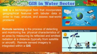
  • 1. GIS is a technological field that incorporates geographical features with tabular data in order to map, analyze, and assess real-world problems. Remote sensing is the process of detecting and monitoring the physical characteristics of an area by measuring its reflected and emitted radiation at a distance (typically from satellite or aircraft). Remote sensed imagery is integrated within a GIS
  • 2. Application of GIS • Urban Planning • Rural Planning • Water • Land Management • Disaster Management • Utility Mapping • Navigation etc.
  • 3. Application of GIS in Water Sector Why ? Using GIS through RS. RS : • Allows rapid assessment of large areas, and selection of subsets for detailed analyses • Water has distinctive spectral properties; water absorbs radiation – in infrared imagery, water appears black • Water quality can also be picked up from remote sensing.
  • 4. Application of GIS in Hydrology GIS Input for : • River Basin Planning/ Modelling • Command Area Management • Storm Water Management Plan • Flood Inundation Study • Rainwater Harvesting and Artificial Recharge • Flood Forecasting • Disaster Early Warning • Watershed Management • Groundwater Assessment • Water Quality Assessment
  • 5. Mapping of Features for Planning through GIS
  • 6. Application of GIS in Hydrology • Catchment Delineation • Extraction of Streams • Delineation of surface water bodies
  • 7. Major GIS Input used in Hydrolgy : • Basin & Sub basin (delineated from DEM), Streams, (captured through images or delineated from DEM) • Land-use/Land-cover Data • Rainfall (spatial distribution through radar satellites) • Soil moisture and its spatial distribution for estimation of crop water use and irrigation requirement • Reservoir water spread through multi-temporal images • Spread of habitation in village/ urban sprawl over time (to assess growth of domestic and municipal water demand over the past and prepare estimates for the future) • Spread of industrial area to corroborate with information on growth pattern of industries, for better estimation of future industrial water demand • Estimation of snow water melt (through spatial coverage of snow bound area and temperature)
  • 8. Application of GIS in Water Utility • Water Supply Design • Sewerage Design • Drainage Design FOR: • Development of hydraulic models, • Creation of thematic maps of the model output results, • Network simplification (skeletonization) for hydraulic modeling, • Estimation of node demands, estimation of node elevations
  • 9. Application of GIS in Watershed Management • Terrain Modelling • Creation of DEMs, • Automated watershed extraction from topography, • Flow determination – direction and accumulation , • Stream-ordering
  • 10. Application of GIS in Flood Management For * Flood plain delineation * Channel characteristics * Inundation modeling * Infrastructure analysis * Risk modeling and mitigation
  • 11. Application GIS in Groundwater Assessment: • Remote sensing can be used to collect information about terrain geology and geomorphology, crucial for estimation of groundwater potential • Lineaments, cracks and fissures and their crossings that are extremely useful for locating wells in hard rock terrain are seldom visible on ground but easily demarcated on satellite images
  • 12. Application of GIS in Irrigation Command Area management • Estimation of crop acreage • Crop production • preparation of “irrigability maps” through land use planning.
  • 13. Application GIS in Quality analysis of water : • Satellite imageries have been used successfully in determination of various water quality parameters like Total Suspended Solids, turbidity, chlorophyll content, colour, temperature etc. By Remote Sensing • Use of GPS for location & photographic tiepoints
  • 14. The latest RS technologies applied in Water Sector include: • 3D surface model analysis • Unmanned aerial vehicle (UAV) video image classification • Ground penetration radar for soil moisture estimation • The Tropical Rainfall Measuring Mission (TRMM) and the Global Precipitation Measurement (GPM) satellite rainfall measurements • Storm hyetography analysis • Rainfall runoff and urban flooding simulation • Satellite radar and optical image classification for urban water bodies and flooding inundation. The application of those technologies is expected to greatly relieve the pressures on water resources and allow better mitigation of and adaptation to the disastrous impact of droughts and flooding.