Geophysical techniques work through applying one of several types of force to the ground, to measure the
resulting energy with use of geophysical equipment and infer the geology from this. Geophysics is generally
much quicker than the aforementioned methods, however, requires more data processing (oìce-based work)
to develop the geological picture. A great advantage of these methods is that certain instruments can be
attached to small aircraft for covering large areas during regional airborne surveys. This provides sparser
geological information, but can highlight potential metal anomalies on a county-country scale, which can be
followed up by more detailed, ground-based geophysical surveys. However, as the material is being tested
indirectly, there is no 100% guarantee of its conclusions; in addition to being susceptible to contamination by
many man-made metallic structures e.g. power-lines. Therefore, should geophysical surveys prove suìciently
interesting, drilling will be required afterwards to conêrm the accuracy of the results.
How can minerals deposits be formed; GEOLOGICAL PROCESSES; Ore Fluids; Ore Forming Processes; Concentrating Processes; Magmatic mineral deposits; Residual mineral deposits ; Placer deposits; Sedimentary mineral deposits; Metamorhogenic mineral deposits; Hydrothermal mineral deposits ; Magmatic Deposits
Cumulate deposits: fractional crystallization processes can concentrate metals (Cr, Fe, PGE, Pt, Ni, Ti, Diamond ))
Pegmatites : late staged crystallization forms pegmatites and many residual elements are concentrated (Li, Ce, Be, Sn, U, Rare Earths (REE), Feldspar, Mica, Gems).
magmatic deposits; Mode of Formation of Magmatic Ores Deposits; Mode of Formation of Orthomagmatic Ores ; Fractional Crystallization (or Crystal fractionation ); Magmatic (or Liquid ) Immiscibility; Simple crystallization without concentration (Dissemination); Segregation of early formed crystals; (Layer Types); Injection of material concentrated elsewhere by differentiation Residual liquid segregation; Residual liquid injection; Immiscible liquid segregation; Immiscible-liquid-injection; Early magmatic deposit; Late magmatic deposit; Types of Magmatic Ore Deposits:Chromite; Fe-Ti (± V) oxides; Ni – Cu – Fe (± Pt) sulfides; Platinum Group Elements (PGEs); REE, and Zr in Carbonatites; Diamond in kimberlites.
THE PRESENCE AND VARIETY OF A PARTICULAR PLANTS
SPECIES IN THE AREA OF MINERALISATION HAVE BEEN RECOGNISED AS A GUIDE TO LOCATING ORE, METHOD,UNIVERSAL INDICATORS , UNIVERSAL INDICATOR ,LOCAL INDICATOR
Gravity anomaly across reagional structuresAmit K. Mishra
Gravity Anomaly across continents and ocean, gravity anomaly across mid-oceanic ridges, gravity anomaly across orogenic belts, and gravity anomaly across subduction zones.
Minerals are formed by changes in chemical energy in systems which contain one fluid or vapor phase. In nature, minerals are formed by crystallisation or precipitation from concentrated solutions. These solutions are called as ore-bearing fluids. Ore-bearing fluids are characterised by high concentration of certain metallic or other elements.
Fluids are the most effective agents for the transport of material in the mantle and the Earth's crust.
CLASSIFICATION OF ORE DEPOSITS
The Mixture of ore minerals are gangue minerals form an Ore deposit. The ore
deposits are generally found enclosed within the country rocks. The ore deposits
are formed in many different ways. Depending upon the process that may
operate to produce them, the ore deposits may be classified as follow:
Magmatic ore deposits.
Sublimation ore deposits.
Pegmatitic ore deposits.
Contact metasomatic ore deposits.
Hydrothermal ore deposits
Cavity filling deposits.
Replacement deposits.
Sedimentation ore deposits.
Evaporation ore deposits.
Residual and mechanical concentration deposits
Metamorphic ore deposits.
MAGMATIC ORE DEPOSITS:
The magmatic ore deposits are the magmatic products which crystallize from
magmas. The magmatic ore deposits are classified as follows:
o Early magmatic deposits
o Late magmatic deposits
Early magmatic deposits:
Early magmatic deposits are formed during the
early stage of the magmatic period. In this case the
ore minerals crystallize earlier than the rock
silicates. The Minerals of Nickel, Chromium, and
Platinum are usually found as early magmatic
deposits. The early magmatic deposits can be sub
divided into two groups:
o Dissemination deposits
o Segregation deposits
Dissemination deposits:
When magma crystallizes
conditions, a granular igneous rock is formed. In
such a rock early formed crystals of
may occur in dissemination.
Segregation deposits:
Magmatic segregation deposits are
formed as a result of gravitative
crystallization differentiation. In
case, the ore mineral which crystallize
early, get ocean-trated on a particular
part of igneous part. The ore deposits
thus formed are known as “Segregation
deposits”.
rly under seated
ore minerals
such
Late Magmatic Deposits:
The ore deposits which are formed to
called late magmatic deposits. The late magmatic deposits contain those ore
minerals which have crystallized at rather low temperature from the residual
magma. The magma which is left after crystallization of early for
is called residual magma. This magma frequently contains many ore minerals. The
late magmatic deposits include most of the magmatic deposits of iron and
titanium ores, these deposits are almost always associated with mafic igneous
rocks.
SUBLIMATION DEPOSITS:
Sublimation is a very minor process of formation of ore deposits. Sublimation
deposits contain only those minerals which have been volatilized by hear and
subsequently redeposit in the same form at low temperature and pressure. The
sublimation deposits are found associated with Volcanoes and Fumaroles. Sulfur
of this origin has been mined in Japan, Italy, and Mexico.
Subsurface Determination Of Cavities In Limestone Rock Area By Geoelectric Me...IJERA Editor
Two Dimensional of geoelectric method can be used to find out the conductive formation in the earth surface. The purpose of this research is to give the description about the geological subsurface formation, that the high resistivity value is indicate the potential area of cave and void in the limestone rocks. The dipole dipolegeoelectric method is used in this research with the path of lines is 250 m with 10 m electrode spacing. The total lines is 7 and the azimuth is from east to west. Resistivity method is started with inject the electrical current into the earth by current electrode, then potential difference will arise and measured by potential electrode. Variation value of resistance for each layer rock can calculated by divided potential defference with current value. The existence of the cavity is known by the resistivity value is more than 2500 ohm-m, while the cracks have a resistivity of 1500 to 2500 ohm-m.
The International Journal of Engineering & Science is aimed at providing a platform for researchers, engineers, scientists, or educators to publish their original research results, to exchange new ideas, to disseminate information in innovative designs, engineering experiences and technological skills. It is also the Journal's objective to promote engineering and technology education. All papers submitted to the Journal will be blind peer-reviewed. Only original articles will be published.
Research Inventy : International Journal of Engineering and Scienceinventy
Research Inventy : International Journal of Engineering and Science is published by the group of young academic and industrial researchers with 12 Issues per year. It is an online as well as print version open access journal that provides rapid publication (monthly) of articles in all areas of the subject such as: civil, mechanical, chemical, electronic and computer engineering as well as production and information technology. The Journal welcomes the submission of manuscripts that meet the general criteria of significance and scientific excellence. Papers will be published by rapid process within 20 days after acceptance and peer review process takes only 7 days. All articles published in Research Inventy will be peer-reviewed.
Evaluation of sub-soil geo-electric properties in a proposed power sub-statio...IJERA Editor
Electrical resistivity survey was carried out in a site proposed for the construction and installation of a Power sub-station. The project will involve subsurface installation of cables and other objects that easily conduct electricity. Extant laws including EIA also require knowledge of subsurface distribution of resistivity in construction projects that would involve burial of steel pipes and cables. The imperative of this is emphasized by the location of the project in an area of shallow groundwater conditions. Field resistivity measurements were undertaken using ABEM Terrameter SAS 1000, adopting Schlumberger configuration in vertical electric sounding at 12 locations within the study site. The results were used to generate geo-electric log models. Three geo-electric profile models (pseudo- profiles) were also taken NE-SW of the site. Interpretation of the models shows that the area is characterized by two geo-electric layers to the depth of 30m. The upper layer of lower resistivity occurs to a depth of 2-3m. This layer consists of lateritic to silty sands. The lower layer has a resistivity of between 900 - >2000 Ωm and represents fine to coarse sands and gravels. On the Soil Electrical Resistivity Classification (BS 1377), the subsoil falls within non-corrosive class. Objects installed in the soil are not likely to suffer corrosion soon. Similarly, subsurface electrical installations will pose minimal hazards and would require basic precautions to avoid electrical accidents.
Research Inventy : International Journal of Engineering and Science is published by the group of young academic and industrial researchers with 12 Issues per year. It is an online as well as print version open access journal that provides rapid publication (monthly) of articles in all areas of the subject such as: civil, mechanical, chemical, electronic and computer engineering as well as production and information technology. The Journal welcomes the submission of manuscripts that meet the general criteria of significance and scientific excellence. Papers will be published by rapid process within 20 days after acceptance and peer review process takes only 7 days. All articles published in Research Inventy will be peer-reviewed.
Immunizing Image Classifiers Against Localized Adversary Attacksgerogepatton
This paper addresses the vulnerability of deep learning models, particularly convolutional neural networks
(CNN)s, to adversarial attacks and presents a proactive training technique designed to counter them. We
introduce a novel volumization algorithm, which transforms 2D images into 3D volumetric representations.
When combined with 3D convolution and deep curriculum learning optimization (CLO), itsignificantly improves
the immunity of models against localized universal attacks by up to 40%. We evaluate our proposed approach
using contemporary CNN architectures and the modified Canadian Institute for Advanced Research (CIFAR-10
and CIFAR-100) and ImageNet Large Scale Visual Recognition Challenge (ILSVRC12) datasets, showcasing
accuracy improvements over previous techniques. The results indicate that the combination of the volumetric
input and curriculum learning holds significant promise for mitigating adversarial attacks without necessitating
adversary training.
Industrial Training at Shahjalal Fertilizer Company Limited (SFCL)MdTanvirMahtab2
This presentation is about the working procedure of Shahjalal Fertilizer Company Limited (SFCL). A Govt. owned Company of Bangladesh Chemical Industries Corporation under Ministry of Industries.
Democratizing Fuzzing at Scale by Abhishek Aryaabh.arya
Presented at NUS: Fuzzing and Software Security Summer School 2024
This keynote talks about the democratization of fuzzing at scale, highlighting the collaboration between open source communities, academia, and industry to advance the field of fuzzing. It delves into the history of fuzzing, the development of scalable fuzzing platforms, and the empowerment of community-driven research. The talk will further discuss recent advancements leveraging AI/ML and offer insights into the future evolution of the fuzzing landscape.
Forklift Classes Overview by Intella PartsIntella Parts
Discover the different forklift classes and their specific applications. Learn how to choose the right forklift for your needs to ensure safety, efficiency, and compliance in your operations.
For more technical information, visit our website https://intellaparts.com
TECHNICAL TRAINING MANUAL GENERAL FAMILIARIZATION COURSEDuvanRamosGarzon1
AIRCRAFT GENERAL
The Single Aisle is the most advanced family aircraft in service today, with fly-by-wire flight controls.
The A318, A319, A320 and A321 are twin-engine subsonic medium range aircraft.
The family offers a choice of engines
Student information management system project report ii.pdfKamal Acharya
Our project explains about the student management. This project mainly explains the various actions related to student details. This project shows some ease in adding, editing and deleting the student details. It also provides a less time consuming process for viewing, adding, editing and deleting the marks of the students.
NO1 Uk best vashikaran specialist in delhi vashikaran baba near me online vas...Amil Baba Dawood bangali
Contact with Dawood Bhai Just call on +92322-6382012 and we'll help you. We'll solve all your problems within 12 to 24 hours and with 101% guarantee and with astrology systematic. If you want to take any personal or professional advice then also you can call us on +92322-6382012 , ONLINE LOVE PROBLEM & Other all types of Daily Life Problem's.Then CALL or WHATSAPP us on +92322-6382012 and Get all these problems solutions here by Amil Baba DAWOOD BANGALI
#vashikaranspecialist #astrologer #palmistry #amliyaat #taweez #manpasandshadi #horoscope #spiritual #lovelife #lovespell #marriagespell#aamilbabainpakistan #amilbabainkarachi #powerfullblackmagicspell #kalajadumantarspecialist #realamilbaba #AmilbabainPakistan #astrologerincanada #astrologerindubai #lovespellsmaster #kalajaduspecialist #lovespellsthatwork #aamilbabainlahore#blackmagicformarriage #aamilbaba #kalajadu #kalailam #taweez #wazifaexpert #jadumantar #vashikaranspecialist #astrologer #palmistry #amliyaat #taweez #manpasandshadi #horoscope #spiritual #lovelife #lovespell #marriagespell#aamilbabainpakistan #amilbabainkarachi #powerfullblackmagicspell #kalajadumantarspecialist #realamilbaba #AmilbabainPakistan #astrologerincanada #astrologerindubai #lovespellsmaster #kalajaduspecialist #lovespellsthatwork #aamilbabainlahore #blackmagicforlove #blackmagicformarriage #aamilbaba #kalajadu #kalailam #taweez #wazifaexpert #jadumantar #vashikaranspecialist #astrologer #palmistry #amliyaat #taweez #manpasandshadi #horoscope #spiritual #lovelife #lovespell #marriagespell#aamilbabainpakistan #amilbabainkarachi #powerfullblackmagicspell #kalajadumantarspecialist #realamilbaba #AmilbabainPakistan #astrologerincanada #astrologerindubai #lovespellsmaster #kalajaduspecialist #lovespellsthatwork #aamilbabainlahore #Amilbabainuk #amilbabainspain #amilbabaindubai #Amilbabainnorway #amilbabainkrachi #amilbabainlahore #amilbabaingujranwalan #amilbabainislamabad
Event Management System Vb Net Project Report.pdfKamal Acharya
In present era, the scopes of information technology growing with a very fast .We do not see any are untouched from this industry. The scope of information technology has become wider includes: Business and industry. Household Business, Communication, Education, Entertainment, Science, Medicine, Engineering, Distance Learning, Weather Forecasting. Carrier Searching and so on.
My project named “Event Management System” is software that store and maintained all events coordinated in college. It also helpful to print related reports. My project will help to record the events coordinated by faculties with their Name, Event subject, date & details in an efficient & effective ways.
In my system we have to make a system by which a user can record all events coordinated by a particular faculty. In our proposed system some more featured are added which differs it from the existing system such as security.
Explore the innovative world of trenchless pipe repair with our comprehensive guide, "The Benefits and Techniques of Trenchless Pipe Repair." This document delves into the modern methods of repairing underground pipes without the need for extensive excavation, highlighting the numerous advantages and the latest techniques used in the industry.
Learn about the cost savings, reduced environmental impact, and minimal disruption associated with trenchless technology. Discover detailed explanations of popular techniques such as pipe bursting, cured-in-place pipe (CIPP) lining, and directional drilling. Understand how these methods can be applied to various types of infrastructure, from residential plumbing to large-scale municipal systems.
Ideal for homeowners, contractors, engineers, and anyone interested in modern plumbing solutions, this guide provides valuable insights into why trenchless pipe repair is becoming the preferred choice for pipe rehabilitation. Stay informed about the latest advancements and best practices in the field.
Automobile Management System Project Report.pdfKamal Acharya
The proposed project is developed to manage the automobile in the automobile dealer company. The main module in this project is login, automobile management, customer management, sales, complaints and reports. The first module is the login. The automobile showroom owner should login to the project for usage. The username and password are verified and if it is correct, next form opens. If the username and password are not correct, it shows the error message.
When a customer search for a automobile, if the automobile is available, they will be taken to a page that shows the details of the automobile including automobile name, automobile ID, quantity, price etc. “Automobile Management System” is useful for maintaining automobiles, customers effectively and hence helps for establishing good relation between customer and automobile organization. It contains various customized modules for effectively maintaining automobiles and stock information accurately and safely.
When the automobile is sold to the customer, stock will be reduced automatically. When a new purchase is made, stock will be increased automatically. While selecting automobiles for sale, the proposed software will automatically check for total number of available stock of that particular item, if the total stock of that particular item is less than 5, software will notify the user to purchase the particular item.
Also when the user tries to sale items which are not in stock, the system will prompt the user that the stock is not enough. Customers of this system can search for a automobile; can purchase a automobile easily by selecting fast. On the other hand the stock of automobiles can be maintained perfectly by the automobile shop manager overcoming the drawbacks of existing system.
Vaccine management system project report documentation..pdfKamal Acharya
The Division of Vaccine and Immunization is facing increasing difficulty monitoring vaccines and other commodities distribution once they have been distributed from the national stores. With the introduction of new vaccines, more challenges have been anticipated with this additions posing serious threat to the already over strained vaccine supply chain system in Kenya.
Vaccine management system project report documentation..pdf
Geophysical methods
1. 12/31/21, 12:04 PM Geophysical Methods
https://www.gsi.ie/en-ie/programmes-and-projects/minerals/activities/mineral-exploration/Pages/Geophysical-Methods.aspx 1/7
Geological Survey Ireland (https://www.gsi.ie/en-ie) Programmes & Projects (https://www.gsi.ie/en-ie/programmes-and-
projects) Minerals (https://www.gsi.ie/en-ie/programmes-and-projects/minerals) Activities (https://www.gsi.ie/en-
ie/programmes-and-projects/minerals/activities) Mineral Exploration, how it's done (https://www.gsi.ie/en-ie/programmes-
and-projects/minerals/activities/mineral-exploration) Geophysical Methods
Geophysical Methods
Geophysical techniques work through applying one of several types of force to the ground, to measure the
resulting energy with use of geophysical equipment and infer the geology from this. Geophysics is generally
much quicker than the aforementioned methods, however, requires more data processing (office-based work)
to develop the geological picture. A great advantage of these methods is that certain instruments can be
attached to small aircraft for covering large areas during regional airborne surveys. This provides sparser
geological information, but can highlight potential metal anomalies on a county-country scale, which can be
followed up by more detailed, ground-based geophysical surveys. However, as the material is being tested
indirectly, there is no 100% guarantee of its conclusions; in addition to being susceptible to contamination by
many man-made metallic structures e.g. power-lines. Therefore, should geophysical surveys prove sufficiently
interesting, drilling will be required afterwards to confirm the accuracy of the results.
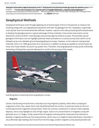
Low-flying plane conducting airborne geophysics survey.
Certain rock-forming minerals have a naturally occurring magnetic property, which when surveying for
magnetism of the rocks, allows them to be identified beneath the surface. In particular these are the iron-
containing minerals magnetite and pyrrhotite. These are common constituents in volcanic metal sulphide
deposits, and so may highlight an area of high copper, lead or zinc concentrations. A magnetic survey will
generally occur in 2 stages. Firstly, several lines of magnetic intensity will be measured at set intervals to
develop a magnetic profile over the measured lines, which may run a length of several kilometres. Secondly, if
any sufficiently high readings were found from the first stage, another magnetic survey would proceed over
Magnetic
Important information regarding cookies and the Geological Survey Ireland website. By using this website, you consent
to the use of cookies in accordance with our Cookie Policy (/en-ie/more-on-us/compliance).
Close
2. 12/31/21, 12:04 PM Geophysical Methods
https://www.gsi.ie/en-ie/programmes-and-projects/minerals/activities/mineral-exploration/Pages/Geophysical-Methods.aspx 2/7
the areas of interest, but this time over a grid pattern as opposed to lines. This latter stage allows a more
detailed understanding of the magnetic intensity of the area, and from this work a map can be produced
showing the magnetic intensity of the underlying rocks.
Magnetic surveys are conducted using equipment called a magnetometer, which can be operated manually as
a handheld version for geologists in the field, or attached to planes for larger regional surveys. The instrument
works in the form of a proton-rich fluid surrounded by an electric coil. A current is applied through the coil to
polarise the fluid. When the current is switched off, the protons realign along the Earth's magnetic field at that
position. Magnetic surveys have several important uses outside of mineral exploration including archaeology
and locating steel and iron man-made structures beneath the surface, including looking for underground
mineshafts from historic mines. This method allows deep penetration and is unaffected by high electrical
ground conductivities, making them useful at sites with saline groundwater, clay or high levels of
contamination where other geophysical methods struggle.
EM surveys differ from magnetic surveys in that as opposed to relying on the signature of naturally high
intensity magnetic minerals, it induces an electromagnetic current into the ground and measures the resulting
field. Because it is not limited to the presence of magnetite and pyrrhotite, it is useful for exploring for a wide
range of metallic minerals, including important metals such as cobalt which is used in batteries for renewable
energy sources. .
The EM system consists of a transmitter and receiver coil which is suspended above the ground. A primary
electromagnetic field is output by the transmission coil which induces a secondary field in the ground – the
magnitude of which is measured by the receiving coil which also measures the ratio between the primary and
secondary fields. The magnitude of the secondary field is proportional to the conductivity of the material and
can be used to detect signs of changes in rock type, potential mineralisation, groundwater, ground
contamination and buried metal man-made objects. Similar to magnetic surveys, EM is conducted on a grid of
sampling points at set intervals.
Electrical resistivity, also known as resistivity, is a bulk electric property of all material that shows how strongly
it opposes the flow of electric current. A low resistivity indicates a material that readily allows the flow of
electric current – i.e. it is conductive. All materials have a certain resistivity and fall within a broad range. The SI
unit for resistivity is the ohmmeter (Ωm). Resistivity surveys can allow for imaging the subsurface of the Earth
on both land and in water, with scans in either 2D sections or 3D volumes of rock. It is used by applying a
small and highly controlled electric current across an array of electrodes, and so resistivity surveys are often
coupled with induced polarisation surveys as the latter also make use of such electrodes.
Because of the conductive properties of various metal-bearing minerals, resistivity can be used in mineral
exploration for metallic ore bodies. However resistivity is an important method for many other studies
including geotechnical and groundwater exploration. For example, geologists can use resistivity imaging to
create a time-lapse of biological or hydrological events over time, to capture % change of dynamic conditions
e.g. examining how water discharges underground, or see how dangerous chemical spillages are moving
underground.
Electromagnetic (EM)
Electrical Resistivity
Important information regarding cookies and the Geological Survey Ireland website. By using this website, you consent
to the use of cookies in accordance with our Cookie Policy (/en-ie/more-on-us/compliance).
Close
3. 12/31/21, 12:04 PM Geophysical Methods
https://www.gsi.ie/en-ie/programmes-and-projects/minerals/activities/mineral-exploration/Pages/Geophysical-Methods.aspx 3/7
Important information regarding cookies and the Geological Survey Ireland website. By using this website, you consent
to the use of cookies in accordance with our Cookie Policy (/en-ie/more-on-us/compliance).
Close
4. 12/31/21, 12:04 PM Geophysical Methods
https://www.gsi.ie/en-ie/programmes-and-projects/minerals/activities/mineral-exploration/Pages/Geophysical-Methods.aspx 4/7
Geologist conducting a resistivity-IP survey.
IP is the Earth's capacity to hold an electric charge over time. It is measured through inducing a current into
the ground, then switching it off and measuring how the voltage decays over time, usually a matter of
seconds, eventually disappearing. Where resistivity answers "What is the resistance to the flow of electric
current?" IP answers "How long do the rocks hold an electric charge?" IP often uses the same cable setup and
same instrument as resistivity surveys, but instead turns off the current and measures the time component. It
uses electrodes.
This method is important because it tests for the capacity of rocks to hold charge and hence properties in the
subsurface that can be used to locate clay and other chargeable minerals. Usually these surveys are very
informative for determining rocks because you end up with both an IP and resistivity map at the same time,
allowing both measurement types to be interpreted. It is therefore important for mineral exploration, as
sulphide minerals – including those hosting gold, silver and copper, generate a very large IP signature. This is
especially useful when the metal-bearing minerals are more loosely distributed within the rock – as opposed
to forming a concentrated ore body. IP also is a useful tool in environmental work e.g. mapping a zone of
contamination to help clean-up.
Seismic surveys are an extremely useful geophysical method for studying the ground conditions to a
significant depth and over a large area. Seismic is utilised in many applications for subsurface investigations,
mineral exploration being one of them. The method operates by emitting a percussive force to the ground,
producing seismic waves which travel through the subsurface, reflecting back or refracting each time a
structure of geological boundary is encountered. Thus from this, the depth and shape of underground
structures can be interpreted from seismic profiles. The initial force can be generated by means of explosives,
or in environmentally sensitive areas (i.e. anywhere on land) dropping a significant weight onto the ground
surface using a hammer-plate or buffalo gun. Refracted waves are detected by an array of geophones which
are spaced at regular intervals. The geophones record the time taken by direct waves, reflected waves and
refracted waves and outputs this data to a seismograph for processing so it can be interpreted for
underground structures. Analysing the time that the soundwaves take to return provides valuable information
about rock types and possible fluids in the rocks, and is similar to the use of ultrasound in medicine.
Induced Polarisation (IP)
Seismic
Important information regarding cookies and the Geological Survey Ireland website. By using this website, you consent
to the use of cookies in accordance with our Cookie Policy (/en-ie/more-on-us/compliance).
Close
5. 12/31/21, 12:04 PM Geophysical Methods
https://www.gsi.ie/en-ie/programmes-and-projects/minerals/activities/mineral-exploration/Pages/Geophysical-Methods.aspx 5/7
Diagram illustrating the principles of seismic exploration.
Onshore seismic surveys have been used in sensitive urban locations without damaging buildings or the
environment, e.g. its use in central Paris. More than four decades of offshore seismics and numerous research
projects have shown the majority of evidence pointing towards such surveys having negligible effects on
marine environments. A case study example of this is the rise of whale populations in Australia on both coasts,
where both are near their biological maximum (10% per year), despite a significantly greater amount of
offshore seismics on the West coast than the East.
Radiometric surveys (also known as Gamma ray spectrometry) are an airborne method which measures the
amounts of natural radiation produced at the Earth's surface. Radioactive uranium, thorium and potassium
minerals occur naturally in rocks, producing relatively high amounts of radiation which can be measured in
contrast to the surrounding rocks. Due to gamma radiation only being able to penetrate several centimetres
of earth/ground, the radioactive materials must be present in outcrops to be detected. However, through
atmosphere, these rays can penetrate up to a couple of hundred metres, and so low-flying aircraft are useful
in this method for covering large regional areas. Because the energy of gamma radiation received is distinctive
of the specific element, it can be used to map uranium-thorium-potassium concentrations over wide areas.
This in turn is used to infer rock types such as granite and zones within rocks that may have been altered by
Radiometric
Important information regarding cookies and the Geological Survey Ireland website. By using this website, you consent
to the use of cookies in accordance with our Cookie Policy (/en-ie/more-on-us/compliance).
Close
6. 12/31/21, 12:04 PM Geophysical Methods
https://www.gsi.ie/en-ie/programmes-and-projects/minerals/activities/mineral-exploration/Pages/Geophysical-Methods.aspx 6/7
metal-rich fluids passing through. It is extremely important to note that these surveys measure levels of
naturally occurring radiation in the rocks, and the instruments themselves do not emit any radiation, making
them harmless to both people and livestock.
Programmes & Projects
Geoenergy (/en-ie/programmes-and-projects/geoenergy/Pages/default.aspx)
Geohazards (/en-ie/programmes-and-projects/geohazards/Pages/default.aspx)
Geoheritage (/en-ie/programmes-and-projects/geoheritage/Pages/default.aspx)
Geological Mapping (/en-ie/programmes-and-projects/geological-mapping/Pages/default.aspx)
Geoscience Ireland (/en-ie/programmes-and-projects/geoscience-ireland/Pages/default.aspx)
Groundwater and Geothermal (/en-ie/programmes-and-projects/groundwater-and-geothermal-
unit/Pages/default.aspx)
Information (/en-ie/programmes-and-projects/information/Pages/default.aspx)
Marine and Coastal (/en-ie/programmes-and-projects/marine-and-coastal-unit/Pages/default.aspx)
Minerals (/en-ie/programmes-and-projects/minerals/Pages/default.aspx)
Projects (/en-ie/programmes-and-projects/minerals/projects/Pages/default.aspx)
Activities (/en-ie/programmes-and-projects/minerals/activities/Pages/default.aspx)
Mineral Exploration (/en-ie/programmes-and-projects/minerals/activities/mineral-exploration/Pages/default.aspx)
Geological Mapping (/en-ie/programmes-and-projects/minerals/activities/mineral-exploration/Pages/Geological-
Mapping.aspx)
Soil Sampling (/en-ie/programmes-and-projects/minerals/activities/mineral-exploration/Pages/Soil-Sampling.aspx)
Stream Sediments (/en-ie/programmes-and-projects/minerals/activities/mineral-exploration/Pages/Stream-
Sediments.aspx)
Drilling (/en-ie/programmes-and-projects/minerals/activities/mineral-exploration/Pages/Drilling.aspx)
Geophysical Methods (/en-ie/programmes-and-projects/minerals/activities/mineral-
exploration/Pages/Geophysical-Methods.aspx)
Mineral Exploration in Ireland FAQs (/en-ie/programmes-and-projects/minerals/activities/mineral-
exploration/Pages/FAQs.aspx)
Representation (/en-ie/programmes-and-projects/minerals/activities/Pages/Representation.aspx)
Data & Maps (/en-ie/programmes-and-projects/minerals/Pages/Data-and-Maps.aspx)
Research (/en-ie/programmes-and-projects/minerals/research/Pages/default.aspx)
Related News (/en-ie/programmes-and-projects/minerals/Pages/related-news.aspx)
Related Publications (/en-ie/programmes-and-projects/minerals/Pages/related-publications.aspx)
Contact Us (/en-ie/more-on-us/contact-us/Pages/default.aspx?anchor=Minerals#Minerals)
Planning (/en-ie/programmes-and-projects/planning/Pages/default.aspx)
Tellus (/en-ie/programmes-and-projects/tellus/Pages/default.aspx)
Urban Geology (/en-ie/programmes-and-projects/urban-geology/Pages/default.aspx)
How and Where We Work (/en-ie/programmes-and-projects/how-and-where-we-
work/Pages/default.aspx)
Important information regarding cookies and the Geological Survey Ireland website. By using this website, you consent
to the use of cookies in accordance with our Cookie Policy (/en-ie/more-on-us/compliance).
Close