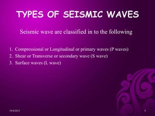
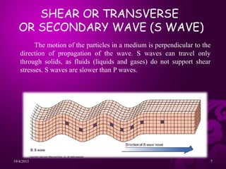
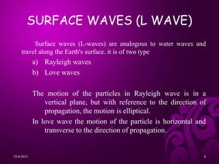
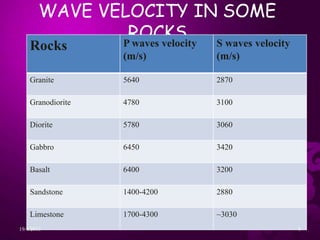
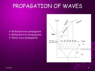
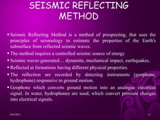
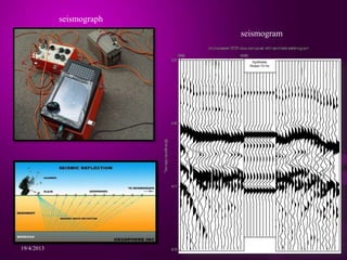
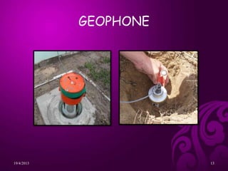
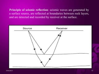
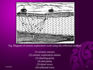
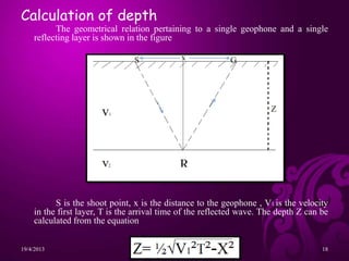
This document provides an overview of seismic prospecting methods. It discusses the different types of seismic waves, including P-waves, S-waves, and surface waves. The seismic reflecting method is described as using controlled seismic sources to generate waves that reflect off underground formations and are detected by sensors at the surface. Reflection seismology can be used to map subsurface geology at various depths for applications in engineering, minerals and hydrocarbon exploration, and studying crustal structures.
It covers seismic method, gravity method, electromagnetic method, magnetic method and radiometric method. all these methods help in mineral exploration
Geophysical techniques work through applying one of several types of force to the ground, to measure the
resulting energy with use of geophysical equipment and infer the geology from this. Geophysics is generally
much quicker than the aforementioned methods, however, requires more data processing (oìce-based work)
to develop the geological picture. A great advantage of these methods is that certain instruments can be
attached to small aircraft for covering large areas during regional airborne surveys. This provides sparser
geological information, but can highlight potential metal anomalies on a county-country scale, which can be
followed up by more detailed, ground-based geophysical surveys. However, as the material is being tested
indirectly, there is no 100% guarantee of its conclusions; in addition to being susceptible to contamination by
many man-made metallic structures e.g. power-lines. Therefore, should geophysical surveys prove suìciently
interesting, drilling will be required afterwards to conêrm the accuracy of the results.
Seismic Refraction Survey for Groundwater Potentials of Northern Paiko Area. ...iosrjce
This paper titled Seismic Refraction Survey for Groundwater Potentials of Southern Paiko Area.
Niger State, Nigeria, employs the service of seismic refraction survey method. A twelve-channel seistronix was
used for the data collection. The profiles were marked at 100 m intervals, while the profiles lines traversed
1000 m (1km). A Total of 44 spreads were shot. Data were collected, Time – distance (T-S) graphs were plotted
using matrix laboratory software, velocities of the underlying layers obtained and depths to the refractor layer
computed and geologic cross sections were obtained. The results obtained gave an overview of the lateral
variation in the lithological changes of the subsurface earth materials in the surveyed area. The basement
surface varied in depth, from 10.16 m to a maximum of 14.80 m. weathered layer velocities ranging from 809
m/s to 3612 m/s and consolidated layer velocities varying between 2858 m/s to 9696 m/s. Four shot points were
delineated as aquifer potentials of the area having depth to refractor varying between 13.70 m and 14.80 m with
overburden velocities ranging from 1940 m/s to 3462 m/s. The rock materials identified in the surveyed area are
chiefly sand, saturated clay, gravel, gneiss, igneous rock and granite.
Subsurface Determination Of Cavities In Limestone Rock Area By Geoelectric Me...IJERA Editor
Two Dimensional of geoelectric method can be used to find out the conductive formation in the earth surface. The purpose of this research is to give the description about the geological subsurface formation, that the high resistivity value is indicate the potential area of cave and void in the limestone rocks. The dipole dipolegeoelectric method is used in this research with the path of lines is 250 m with 10 m electrode spacing. The total lines is 7 and the azimuth is from east to west. Resistivity method is started with inject the electrical current into the earth by current electrode, then potential difference will arise and measured by potential electrode. Variation value of resistance for each layer rock can calculated by divided potential defference with current value. The existence of the cavity is known by the resistivity value is more than 2500 ohm-m, while the cracks have a resistivity of 1500 to 2500 ohm-m.
Hydrogeological Application of Refraction Seismicsiosrjce
IOSR Journal of Environmental Science, Toxicology and Food Technology (IOSR-JESTFT) multidisciplinary peer-reviewed Journal with reputable academics and experts as board member. IOSR-JESTFT is designed for the prompt publication of peer-reviewed articles in all areas of subject. The journal articles will be accessed freely online.
Shear wave velocity and Geology Based Seismic Microzonation of Port-au-Prince...Johana Sharmin
This is a presentation entirely based on the paper published by Brady R. Cox and his team. I just focused on the key points of the paper in the presentation.
Adjusting primitives for graph : SHORT REPORT / NOTESSubhajit Sahu
Graph algorithms, like PageRank Compressed Sparse Row (CSR) is an adjacency-list based graph representation that is
Multiply with different modes (map)
1. Performance of sequential execution based vs OpenMP based vector multiply.
2. Comparing various launch configs for CUDA based vector multiply.
Sum with different storage types (reduce)
1. Performance of vector element sum using float vs bfloat16 as the storage type.
Sum with different modes (reduce)
1. Performance of sequential execution based vs OpenMP based vector element sum.
2. Performance of memcpy vs in-place based CUDA based vector element sum.
3. Comparing various launch configs for CUDA based vector element sum (memcpy).
4. Comparing various launch configs for CUDA based vector element sum (in-place).
Sum with in-place strategies of CUDA mode (reduce)
1. Comparing various launch configs for CUDA based vector element sum (in-place).
StarCompliance is a leading firm specializing in the recovery of stolen cryptocurrency. Our comprehensive services are designed to assist individuals and organizations in navigating the complex process of fraud reporting, investigation, and fund recovery. We combine cutting-edge technology with expert legal support to provide a robust solution for victims of crypto theft.
Our Services Include:
Reporting to Tracking Authorities:
We immediately notify all relevant centralized exchanges (CEX), decentralized exchanges (DEX), and wallet providers about the stolen cryptocurrency. This ensures that the stolen assets are flagged as scam transactions, making it impossible for the thief to use them.
Assistance with Filing Police Reports:
We guide you through the process of filing a valid police report. Our support team provides detailed instructions on which police department to contact and helps you complete the necessary paperwork within the critical 72-hour window.
Launching the Refund Process:
Our team of experienced lawyers can initiate lawsuits on your behalf and represent you in various jurisdictions around the world. They work diligently to recover your stolen funds and ensure that justice is served.
At StarCompliance, we understand the urgency and stress involved in dealing with cryptocurrency theft. Our dedicated team works quickly and efficiently to provide you with the support and expertise needed to recover your assets. Trust us to be your partner in navigating the complexities of the crypto world and safeguarding your investments.
Explore our comprehensive data analysis project presentation on predicting product ad campaign performance. Learn how data-driven insights can optimize your marketing strategies and enhance campaign effectiveness. Perfect for professionals and students looking to understand the power of data analysis in advertising. for more details visit: https://bostoninstituteofanalytics.org/data-science-and-artificial-intelligence/
Techniques to optimize the pagerank algorithm usually fall in two categories. One is to try reducing the work per iteration, and the other is to try reducing the number of iterations. These goals are often at odds with one another. Skipping computation on vertices which have already converged has the potential to save iteration time. Skipping in-identical vertices, with the same in-links, helps reduce duplicate computations and thus could help reduce iteration time. Road networks often have chains which can be short-circuited before pagerank computation to improve performance. Final ranks of chain nodes can be easily calculated. This could reduce both the iteration time, and the number of iterations. If a graph has no dangling nodes, pagerank of each strongly connected component can be computed in topological order. This could help reduce the iteration time, no. of iterations, and also enable multi-iteration concurrency in pagerank computation. The combination of all of the above methods is the STICD algorithm. [sticd] For dynamic graphs, unchanged components whose ranks are unaffected can be skipped altogether.
3. INTRODUCTION
PROSPECTING is the first stage of the geological analysis,
physical search for hydrocarbons, minerals, fossils, precious metals or
mineral specimens, and is also known as fossicking.
GEOPHYSICAL PROSPECTING is the study of the structure of the
earth’s crust by physical methods for the location and surveying of
minerals, it is an integral part of geophysics.
GEOPHYSICAL PROSPECTING TECHNIQUES:
Seismic method.
Gravity method.
Magnetic method.
Electrical method.
Radioactive method.
Well logging method
Electromagnetic method
19/4/2013 3
4. Prospecting based on the analysis of elastic waves generated in the
earth by artificial means.
The elastic waves produced during sudden disturbance is called as
Seismic wave. These seismic waves are recorded using the instrument
Seismograph and the record obtained is Seismogram.
It is an important geophysical prospecting applied in exploration
of oil and natural gas deposits, deep ground water exploration, depth
estimation, geotechnical problems.
Seismic prospecting can be done by two methods
1. Reflection method
2. Refraction method
SEISMIC PROSPECTING
19/4/2013 4
5. TYPES OF SEISMIC WAVES
Seismic wave are classified in to the following
1. Compressional or Longitudinal or primary waves (P waves)
2. Shear or Transverse or secondary wave (S wave)
3. Surface waves (L wave)
19/4/2013 5
6. Motion of the particles in a medium is parallel to direction of
propagation of the wave. It has the highest velocity and is therefore
the first to be recorded, These waves can travel through any type
of material, including fluids. It is formed from
alternating compressions and expansions.
COMPRESSIONAL OR
LONGITUDINAL OR PRIMARY
WAVES (P WAVES)
19/4/2013 6
7. The motion of the particles in a medium is perpendicular to the
direction of propagation of the wave. S waves can travel only
through solids, as fluids (liquids and gases) do not support shear
stresses. S waves are slower than P waves.
SHEAR OR TRANSVERSE
OR SECONDARY WAVE (S WAVE)
19/4/2013 7
8. SURFACE WAVES (L WAVE)
Surface waves (L-waves) are analogous to water waves and
travel along the Earth's surface. it is of two type
a) Rayleigh waves
b) Love waves
The motion of the particles in Rayleigh wave is in a
vertical plane, but with reference to the direction of
propagation, the motion is elliptical.
In love wave the motion of the particle is horizontal and
transverse to the direction of propagation.
19/4/2013 8
9. WAVE VELOCITY IN SOME
ROCKS
Rocks P waves velocity
(m/s)
S waves velocity
(m/s)
Granite 5640 2870
Granodiorite 4780 3100
Diorite 5780 3060
Gabbro 6450 3420
Basalt 6400 3200
Sandstone 1400-4200 2880
Limestone 1700-4300 ~3030
19/4/2013 9
11. SEISMIC REFLECTING
METHOD
Seismic Reflecting Method is a method of prospecting, that uses the
principles of seismology to estimate the properties of the Earth's
subsurface from reflected seismic waves.
The method requires a controlled seismic source of energy
Seismic waves generated… dynamite, mechanical impact, earthquakes.
Reflected at formations having different physical properties.
The reflection are recorded by detecting instruments (geophone,
hydrophone) responsive to ground motion.
Geophone which converts ground motion into an analogue electrical
signal. In water, hydrophones are used, which convert pressure changes
into electrical signals.
19/4/2013 11
15. Principle of seismic reflection: seismic waves are generated by
a surface source, are reflected at boundaries between rock layers,
and are detected and recorded by receiver at the surface.
19/4/2013 15
16. SEISMIC SURVEY
• Seismic surveys use vibration induced by a sound
generating equipment to provide a picture of subterranean rock
formations found at depth [30,000 feet below ground level (BGL)].
This is accomplished by generating sound waves downward into the
earth's crust which are reflected through various boundaries between
different rock strata. On land, the sound waves are generated by
small explosive charges embedded in the ground or by vibrator
trucks, referred to as thumpers which shake the ground.
• The human ear can barely hear the thump, but the
frequency generated penetrates the earth's crust. The echoes are
detected by electronic devices called geophones which receive the
reflected sound waves and the data are recorded on magnetic tape
which is printed to produce a two-dimensional graphic data through
which illustration of the subsurface can be done.
19/4/2013 16
17. Fig. Diagram of seismic exploration work using the reflection method:
(1) seismic sensors,
(2) seismic exploration station,
(3) shooting point,
(4) shot point,
(5) direct wave,
(6) reflected wave
19/4/2013 17
18. Calculation of depth
The geometrical relation pertaining to a single geophone and a single
reflecting layer is shown in the figure
S is the shoot point, x is the distance to the geophone , V1 is the velocity
in the first layer, T is the arrival time of the reflected wave. The depth Z can be
calculated from the equation
19/4/2013 18
S G
Z
x
19. APPLICATIONS
Reflection seismology is used extensively in a number of fields and
its applications can be categorized into three groups, each defined by
their depth of investigation:
Near-surface applications – to understand geology at depths of up to
approximately 1 km, used for engineering and environmental surveys, as
well as coal and mineral exploration, for geothermal energy surveys.
Hydrocarbon exploration: Hydrocarbon exploration used by the
hydrocarbon industry to provide a high resolution map of acoustic
impedance contrasts at depths of up to 10 km within the subsurface.
Crustal studies – investigation of the structure and origin of the Earth's
crust, through to the Mohorovicic discontinuity and beyond, at depths of
up to 100 km.
19/4/2013 19
20. CONCLUSION
• GEOPHYSICAL PROSPECTING : The study of the structure of the
earth’s crust by physical methods for the location and surveying of
minerals.
• Seismic prospecting can be done by two methods, reflection and
refraction seismic method.
• Seismic Reflecting Method is a method of prospecting, that uses the
principles of seismology to estimate the properties of the Earth's
subsurface from reflected seismic waves.
• Reflection seismology is used in three types of applications:-
Near-surface applications, Hydrocarbon exploration, Crustal studies.
19/4/2013 20
21. REFERENCE
• Milton. B. Dobrin, Introduction to Geophysical
prospecting, Third edition, McGaaw-Hill Book Company,
pp:292-338.
• M.B. Ramachandra Rao, Outlines of Geophysical
prospecting- A manual for Geologists, Prasaranga Mysore,
pp:243-264.
Websites:
http://en.wikipedia.org/wiki/Reflection_seismology
http://aspire.cosmic-ray.org/labs/seismic/index.htm
www.zonge.com/PDF_Papers/GeophysicalProspec
tingMethods.pdf
19/4/2013 21