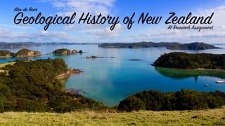
The document discusses the geological history of New Zealand. It begins by explaining plate tectonics and the different types of boundaries where tectonic plates meet. It then describes how the Southern Alps mountain range in New Zealand was formed by the collision and movement of the Indo-Australian and Pacific tectonic plates along the Alpine Fault line. The document also discusses scree slopes, which are areas of loose rock debris found at the base of mountains, and how they are created through erosion. It explains how glaciers form and describes some of the major glacial lakes in Southland, New Zealand that were left behind when glaciers receded. Finally, it provides information about volcanoes in New Zealand's North Island
This document covers rivers from the CSEC Geography syllabus. It covers the water cycle, drainage basin, drainage density, drainage patterns, river processes, characteristics of rivers and river landforms
Earth is the third planet from the Sun and the only object in the Universe known to harbor life. According to radiometric dating and other sources of evidence, Earth formed over 4 billion years ago.[24][25][26] Earth's gravity interacts with other objects in space, especially the Sun and the Moon, Earth's only natural satellite. Earth revolves around the Sun in 365.26 days, a period known as an Earth year. During this time, Earth rotates about its axis about 366.26 times.[n 5]
Earth's axis of rotation is tilted, producing seasonal variations on the planet's surface.[27] The gravitational interaction between the Earth and Moon causes ocean tides, stabilizes the Earth's orientation on its axis, and gradually slows its rotation.[28] Earth is the densest planet in the Solar System and the largest of the four terrestrial planets.
Earth's lithosphere is divided into several rigid tectonic plates that migrate across the surface over periods of many millions of years. About 71% of Earth's surface is covered with water, mostly by oceans.[29] The remaining 29% is land consisting of continents and islands that together have many lakes, rivers and other sources of water that contribute to the hydrosphere. The majority of Earth's polar regions are covered in ice, including the Antarctic ice sheet and the sea ice of the Arctic ice pack. Earth's interior remains active with a solid iron inner core, a liquid outer core that generates the Earth's magnetic field, and a convecting mantle that drives plate tectonics.
Within the first billion years of Earth's history, life appeared in the oceans and began to affect the Earth's atmosphere and surface, leading to the proliferation of aerobic and anaerobic organisms. Some geological evidence indicates that life may have arisen as much as 4.1 billion years ago. Since then, the combination of Earth's distance from the Sun, physical properties, and geological history have allowed life to evolve and thrive.[30][31] In the history of the Earth, biodiversity has gone through long periods of expansion, occasionally punctuated by mass extinction events. Over 99% of all species[32] that ever lived on Earth are extinct.[33][34] Estimates of the number of species on Earth today vary widely;[35][36][37] most species have not been described.[38] Over 7.4 billion humans live on Earth and depend on its biosphere and natural resources for their survival. Humans have developed diverse societies and cultures; politically, the world has about 200 sovereign states.
For the Leaving Certificate Geography Syllabus (Ireland). Contains some past questions and other activities. Deals with Destructive, Transverse and Constructive Plate boundaries and the theories of Sea Floor Spreading and Continental Drift
This document looks at the factors that affect weather and climate. The weather systems that also affect the Caribbean is also examined. These include ITCZ, Hurricanes, Cold Fronts, Easterly waves, Anticyclones
New zealand introduction, new zealand general geography,.... New zealand main Islands..north islands south islands main geographic divisions of New zealand... Natural vegetation and Animal life of newzealnd...economy of new zealand
This is the entire CSEC geography syllabus (some things might be missing). The information was collected from various websites and textbooks. The topics are:
- Internal forces
-External forces
-Rivers
-Limestone
-Coasts
-Coral reefs and Mangroves
-Weather and Climate
- Ecosystems (vegetation and soils)
-Natural hazards
- Urbanization
-Economic activity
-Environmental degradation
CSEC Geography- Internal Forces - Plate Tectonics and EarthquakesOral Johnson
This document looks at the Earth's internal forces. The main layers of the earth are described. The history surrounding plate tectonics is discussed. The different types of plate boundaries is also explained.
World Geography
The rocky ball that forms our world is one of nine planets in the Solar System. Earth is a sphere, with a
slight bulge in the middle at the Equator, and a diameter of 12,756 km (7,926 miles). It hurtles at speeds
of 105,000 kph (65,000 mph) during its orbit around the Sun, turning on its AXIS once every 24 hours.
This journey takes a year to complete. The Earth is the only planet that is known to support life, in a zone
called the BIOSPHERE.
UNIQUE PLANET
Water, oxygen, and energy from the Sun combine on Earth to help create suitable conditions for life.
The planet’s surface is mainly liquid water, which is why it looks blue from space. Earth is the only planet
in the Solar System with an atmosphere that contains a large amount of oxygen. The Sun is 150 million
km (93 million miles) away, producing heat that is bearable on Earth.
ATMOSPHERE
The atmosphere is a layer of gas surrounding the Earth that is some 700 km (400 miles) thick. It is made
up of nitrogen (78 per cent) and oxygen (21 per cent), plus traces of other gases. Tiny droplets of water
vapour form the clouds we see.
OCEANS
Oceans cover 70.8 per cent of the Earth’s surface, to an average depth of 3.5 km (2 miles). The
hydrosphere (watery zone) also includes freshwater rivers and lakes, but these make up less than 1 per
cent of Earth’s water.
LAND
Dry land occupies 29.2 per cent of the Earth’s surface, where the lithosphere (rocky crust) rises above
sea level to form seven continents and countless smaller islands. Land can be categorised into biomes
major habitats such as forests, grasslands, and deserts.
ICE AND SNOW
The cryosphere (frozen zone) includes snow and glaciers on high mountains, sea ice, and the huge ice caps
that cover the landmasses of Greenland and the Antarctic. In the past, during long cold eras called ice
ages, ice covered much more of Earth’s surface than it does today.
EARTH SCIENCE
Meteorology, the study of Earth’s atmosphere, is one of the Earth sciences. Earth scientists study Earth’s
physical characteristics, from raindrops to rivers and the rocks beneath our feet. Other branches of study
include geology (rocks), hydrology, (oceans and freshwater), and ecology (living things and the
environment).
STUDY TECHNIQUES
Satellite images allow scientists to monitor everything from ocean currents to minerals hidden below
ground. Techniques such as radar and sonar have transformed our understanding of our planet. Some
Earth scientists also spend time in the field, which means working outdoors, collecting data and samples
from clouds, cliffs, craters, volcanic lava, and deep-buried ice.
BIOSPHERE
The biosphere is the part of Earth that contains what is needed for living things. This zone extends from
the ocean floor to top of the troposphere (lower atmosphere). Tiny organisms can survive deep in the
Earth’s crust, but most forms of life are found from a few hundred metres below sea level to about 1,000
m (3,300 ft) above sea level.
TH
2024.06.01 Introducing a competency framework for languag learning materials ...Sandy Millin
http://sandymillin.wordpress.com/iateflwebinar2024
Published classroom materials form the basis of syllabuses, drive teacher professional development, and have a potentially huge influence on learners, teachers and education systems. All teachers also create their own materials, whether a few sentences on a blackboard, a highly-structured fully-realised online course, or anything in between. Despite this, the knowledge and skills needed to create effective language learning materials are rarely part of teacher training, and are mostly learnt by trial and error.
Knowledge and skills frameworks, generally called competency frameworks, for ELT teachers, trainers and managers have existed for a few years now. However, until I created one for my MA dissertation, there wasn’t one drawing together what we need to know and do to be able to effectively produce language learning materials.
This webinar will introduce you to my framework, highlighting the key competencies I identified from my research. It will also show how anybody involved in language teaching (any language, not just English!), teacher training, managing schools or developing language learning materials can benefit from using the framework.
Instructions for Submissions thorugh G- Classroom.pptxJheel Barad
This presentation provides a briefing on how to upload submissions and documents in Google Classroom. It was prepared as part of an orientation for new Sainik School in-service teacher trainees. As a training officer, my goal is to ensure that you are comfortable and proficient with this essential tool for managing assignments and fostering student engagement.
Honest Reviews of Tim Han LMA Course Program.pptxtimhan337
Personal development courses are widely available today, with each one promising life-changing outcomes. Tim Han’s Life Mastery Achievers (LMA) Course has drawn a lot of interest. In addition to offering my frank assessment of Success Insider’s LMA Course, this piece examines the course’s effects via a variety of Tim Han LMA course reviews and Success Insider comments.
Read| The latest issue of The Challenger is here! We are thrilled to announce that our school paper has qualified for the NATIONAL SCHOOLS PRESS CONFERENCE (NSPC) 2024. Thank you for your unwavering support and trust. Dive into the stories that made us stand out!
Welcome to TechSoup New Member Orientation and Q&A (May 2024).pdfTechSoup
In this webinar you will learn how your organization can access TechSoup's wide variety of product discount and donation programs. From hardware to software, we'll give you a tour of the tools available to help your nonprofit with productivity, collaboration, financial management, donor tracking, security, and more.
Model Attribute Check Company Auto PropertyCeline George
In Odoo, the multi-company feature allows you to manage multiple companies within a single Odoo database instance. Each company can have its own configurations while still sharing common resources such as products, customers, and suppliers.
Palestine last event orientationfvgnh .pptxRaedMohamed3
An EFL lesson about the current events in Palestine. It is intended to be for intermediate students who wish to increase their listening skills through a short lesson in power point.
Synthetic Fiber Construction in lab .pptxPavel ( NSTU)
Synthetic fiber production is a fascinating and complex field that blends chemistry, engineering, and environmental science. By understanding these aspects, students can gain a comprehensive view of synthetic fiber production, its impact on society and the environment, and the potential for future innovations. Synthetic fibers play a crucial role in modern society, impacting various aspects of daily life, industry, and the environment. ynthetic fibers are integral to modern life, offering a range of benefits from cost-effectiveness and versatility to innovative applications and performance characteristics. While they pose environmental challenges, ongoing research and development aim to create more sustainable and eco-friendly alternatives. Understanding the importance of synthetic fibers helps in appreciating their role in the economy, industry, and daily life, while also emphasizing the need for sustainable practices and innovation.
Macroeconomics- Movie Location
This will be used as part of your Personal Professional Portfolio once graded.
Objective:
Prepare a presentation or a paper using research, basic comparative analysis, data organization and application of economic information. You will make an informed assessment of an economic climate outside of the United States to accomplish an entertainment industry objective.
How to Make a Field invisible in Odoo 17Celine George
It is possible to hide or invisible some fields in odoo. Commonly using “invisible” attribute in the field definition to invisible the fields. This slide will show how to make a field invisible in odoo 17.
A Strategic Approach: GenAI in EducationPeter Windle
Artificial Intelligence (AI) technologies such as Generative AI, Image Generators and Large Language Models have had a dramatic impact on teaching, learning and assessment over the past 18 months. The most immediate threat AI posed was to Academic Integrity with Higher Education Institutes (HEIs) focusing their efforts on combating the use of GenAI in assessment. Guidelines were developed for staff and students, policies put in place too. Innovative educators have forged paths in the use of Generative AI for teaching, learning and assessments leading to pockets of transformation springing up across HEIs, often with little or no top-down guidance, support or direction.
This Gasta posits a strategic approach to integrating AI into HEIs to prepare staff, students and the curriculum for an evolving world and workplace. We will highlight the advantages of working with these technologies beyond the realm of teaching, learning and assessment by considering prompt engineering skills, industry impact, curriculum changes, and the need for staff upskilling. In contrast, not engaging strategically with Generative AI poses risks, including falling behind peers, missed opportunities and failing to ensure our graduates remain employable. The rapid evolution of AI technologies necessitates a proactive and strategic approach if we are to remain relevant.
2. The Southern Alps and Plate
Tectonics
What is the theory of plate tectonics?
Plate tectonics is a theory that states the outer
shell of the earth is divided into sections, known as
plates. There are eight major tectonic plates on the
earth’s surface. These plates are made of solid
rock and are said to be constantly floating around
on the uppermost mantle, which is made of molten
rock. Magma rises up from the mantle due to
convection currents, causing the plates to move
around. There is a lot of evidence, such as the fact
that the coastlines of multiple continents fit
together like a puzzle, and the fact that rock types
are similar between different continents, that
suggests these plates are indeed moving and were
once joined together into a single landmass,
known as Pangaea, millions of years ago.
3. Types of Tectonic Plate Boundaries
Divergent Boundaries
Divergent plate boundaries occur where two
plates are moving away from each other. Lava
is expelled from the fissures (gaps) between
the plates. Volcanoes are often formed here.
Convergent Boundaries
Convergent plate boundaries occur when two
plates collide with each other. They can either
push each other up to form volcanoes, or one
can slip underneath the other, with the top one
becoming a mountain range.
Transform Boundaries
Transform plate boundaries occur when two
plates slide past each other. They may grind
together, causing earthquakes and breaking
and crushing the rocks that make up the
edges of the respective plates.
4. The Southern Alps and Plate
Tectonics
How were the Southern Alps formed?
The Southern Alps of New Zealand were formed
because of uplift between two tectonic plates. Uplift
occurs when two tectonic plates collide together,
and their edges are pushed upward to form
mountains. Anywhere from 5 to 15 million years
ago, the Southern Alps were formed when the Indo-
Australian and Pacific plates collided and the Pacific
plate moved over the Australian plate. This area of
collision is also known as the Alpine Fault.
Currently, the two plates are still moving towards
each other, causing the Southern Alps to grow at a
rate of 10-20mm each year. As well as moving
towards each other, the two plates are sliding past
each other. This means that the Alpine Fault is quite
prone to earthquakes.
5. The Southern Alps and Plate
Tectonics
How do plate tectonics and the Southern
Alps affect us?
There are some very obvious affects that plate
tectonics has had on our landscape - namely, the
creation of the Southern Alps. As well this, there
have been numerous earthquakes in New Zealand
caused by the Indo-Australian and Pacific plates
grinding against each other on the Alpine Fault.
The Southern Alps are very important in terms of
tourism as well - the spectacular scenery and
clean, beautiful environment means that each year,
many thousands of people explore these natural
wonders.
6. Scree Slopes in the South
Island
What are scree slopes?
Scree slopes are large deposits of loose rock
debris, typically found at the bases of cliffs or
mountains. The rocks on the scree slopes move
gradually downwards, meaning that it is difficult
for any vegetation to grow on them.
Scree slopes exist on and around the mountains of
the South Island. They can be made of any type of
rock, but I presume that the ones in the southern
alps are made up of Greywacke rocks, a type of
sandstone, because these are what the southern
alps themselves are composed of.
7. Scree Slopes in the South
Island
What is erosion?
Erosion is a natural process where forces such as wind
or water flow take earth and rock from one place and
deposit it in another. Humans can also cause erosion; for
example, by removing plants or trees that are holding
banks or cliffs together with their roots. Earthquakes
and cyclones can also cause what is known as
accelerated erosion. Erosion is almost never desirable
and is often detrimental to the environment.
Scree slopes are the product of erosion; they are made
when cliffs or mountains are weathered down over time
and their rocks are taken from the top and deposited at
the bottom. This can occur in many ways. In cold
climates, if water gets into cracks in the rock and
expands when it freezes into ice, this is enough to
displace the rock and cause it to fall to the bottom of the
slope. Alternatively, the wind and rain can displace rock
that is part of the mountain and contribute to scree
slopes.
8. Scree Slopes in the South
Island
How do the scree slopes in the South Island
affect us?
Weathering and the creation of scree slopes
dramatically affects the height of our mountains; if it
was not for weathering, the southern alps could be up
to six times the height they are today! As well as this,
scree slopes prohibit plant and vegetation growth at
the bottom of mountains because they crush them
and move over them slowly, which prevents them
from regrowing.
Scree slopes are hiked up or across by people who
want a challenge. The rocks often come loose and
walking around on them can be very dangerous.
Hikers also descend the slopes by ‘skiing’ down them
in their boots. This creates small rockslides.
When scree slopes break down, they move into lakes
and streams, carrying sediment with them. This
sediment pollutes the bodies of water.
9. Scree Slopes in the South
Island
How does erosion in general affect us?
Erosion is never beneficial to humans or the
environment, and is often detrimental. It affects the
environment by stripping away topsoil on farms.
This leads to reduced ability of the crops to store
water and nutrients and in turn can lower the
amount of crops that are yielded. As well as this,
the wind and rain can cause silt to be deposited
into, and reduce the quality of, bodies of water.
Finally, erosion can also affect urban settlements
and infrastructure if water or wind strips away the
terrain beneath them and the land becomes
unstable.
10. The Glacial Lakes of Southland
What are glaciers, and how do they form?
Glaciers are masses of dense ice that are slowly
moving under their own weight, and also due to
gravity. They are formed over many thousands of
years, when the amount of snow produced in one
area is greater than the amount of snow that
melts. This snow turns into ice and layers of it are
formed over time.
Glaciers can cause erosion in walls of rock by a
process called Freeze Thaw. This means that when
they melt, the water forces its way in cracks in the
rock, then freezes back into ice and expands. This
causes the rock to break apart under this strain.
Some of the largest glaciers in New Zealand
include Fox Glacier, Franz-Josef Glacier and
Tasman Glacier.
11. The Glacial Lakes of Southland
What are glacial lakes?
Glacial lakes are lakes which are formed when a
glacier erodes the land and then melts, leaving behind
water which fills the space it eroded. When the last
glacial period, the Pleistocene period, ended around
10,000 years ago, the glaciers began to retreat, leaving
behind large ice deposits that melted to form lakes.
To see an explanation of erosion, please refer to the
previous segment about scree slopes.
Which glacial lakes do we have in Southland?
Some of the main lakes we have in Southland are
Lake Manapōuri, Lake Hauroko (both in the Fiordland
National Park) and Lake Te Anau (partly in the
National Park). Lake Manapōuri is 28km long and is
444m deep, while Lake Hauroko is 30km long, and is
462m deep, making it New Zealand’s deepest lake.
They are thought to occupy the area of glaciers that
were formed in the Pleistocene period.
12. The Glacial Lakes of Southland
How do the glacial lakes of Southland
affect us?
Lake Manapōuri is a lake that is widely known for
its great water quality and is a great place to go
fishing. The lake also provides hydroelectric power
to New Zealand through a hydroelectric power
station.
All three of the lakes detailed on the previous slide
are tourist attractions. They are situated in the
Fiordland National Park, a World Heritage Site, and
many tourists stop to admire them each year. Boat
tours are also held on the lakes for tourists.
13. Earthquakes and Volcanoes in
the North Island
What are volcanoes, and why do
earthquakes occur?
Volcanoes and earthquakes are both products of plate tectonics.
Volcanoes, weaknesses of the earth’s crust where magma is
forced out, are formed when two tectonic plates move apart or
collide with each other, causing gaps to form, or when cracks are
formed in the surface of a plate. Magma rises up through these
gaps and hardens to form the conical structures that are known as
volcanoes. Underneath the volcanoes, magma continues to rise up
because it is less dense than the rocks that surround it. As it does
this, the gas in the magma becomes bubbles, and creates
pressure on the layers of rock at the top of the volcano. Once this
pressure is too much for the volcano to contain, it bursts open and
lava is propelled out in what is known as an eruption. The lava that
has erupted then hardens and becomes the top layer of rock on the
volcano. Earthquakes occur when two tectonic plates slide past
each other in what is known as transform faulting. Pieces of rock
on each of the plates lock together, causing the plates to slide to a
halt. However, when the force on the rocks causes them to break
and the plates start moving again, a large amount of energy is
released, which causes the surrounding areas to shake violently.
14. Earthquakes and Volcanoes in
the North Island
What volcanoes do we have in the North Island?
The largest volcanoes in the North Island include Mt.
Tongariro, Mt. Ngaruhoe, Mt. Ruapehu, White Island and Mt.
Taranaki (also known as Mt. Egmont). All of these
mountains are part of the Pacific Ring of Fire, an area of the
Pacific Ocean where a large number of volcanic eruptions
occur. They have been formed because, in the past, magma
was produced when the Pacific plate was forced under the
Indo-Australian plate in a process known as subduction.
Then the magma protruded through weaknesses and rifts in
the surface of the plates, then solidified into rock, forming
conical volcanoes.
Auckland is the place of a volcanic hotspot. This means that,
deep underneath the earth, the temperatures are extremely
high. This means that, every few hundred years, the very hot
lava melts the rock of the crust and makes its way up to the
weak area underneath Auckland, where it pushes through
to form volcanic cones. This is how Auckland’s volcanic field
formed.
The volcanoes in the North Island contain moderate
amounts of silica, which means that they are fairly runny.
15. Earthquakes and Volcanoes in
the North Island
How do earthquakes and volcanoes affect
us?
Earthquakes and volcanoes can kill thousands of people
who are close when the disaster occurs - for example, the
explosion of Mt. Tambora in Indonesia killed 92,000 people,
while the Christchurch earthquake of 2011 caused 185
deaths. As well as this, earthquakes and volcanoes cost
cities billions of dollars in rebuild costs.
Volcanoes also put gas and ash into the atmosphere, which
causes air pollution. They propel sulphur dioxide into the air,
which reacts to form sulphuric acid. This can prevent heat
from escaping from the earth’s atmosphere, which
contributes to the global warming.
One interesting impact of volcanoes on the environment is
that they can form vibrant sunsets!
Earthquakes can accelerate erosion by causing the land to
shake, which makes cliffs break down. They also destroy
vegetation in forests, which allows sunlight to go through the
forest canopy and facilitate the growth of new types of
plants.