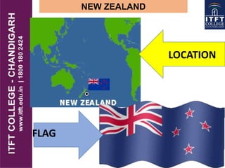
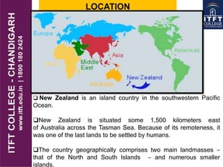
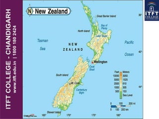
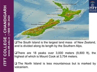
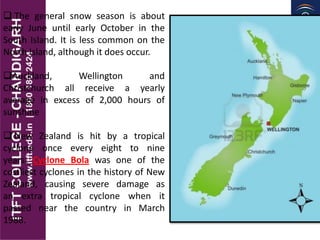
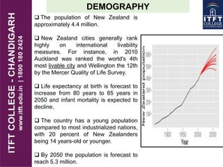
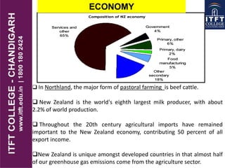
NEW ZEALAND
LOCATION
FLAG
LOCATION
 New Zealand is an island country in the southwestern Pacific
Ocean.
New Zealand is situated some 1,500 kilometers east
of Australia across the Tasman Sea. Because of its remoteness, it
was one of the last lands to be settled by humans.
The country geographically comprises two main landmasses ‒
that of the North and South Islands ‒ and numerous smaller
islands.
CAPITAL OF NEWZEALAND
Wellington is the capital city and
second most populous urban
area of New Zealand. It is at the
southwestern tip of the North
Island, It is home to 395,600
residents.
Population: 4,107,000
Capital: Wellington
Area:2,70,534 square kms
Language: English, Maori
Religion: Protestant, Roman
Catholic
Currency: New Zealand dollar
New Zealand is made up of two
main islands and a number of smaller
islands, located near the centre of the
water.
The main North and South
Islands are separated by the Cook
Strait 22 kilometers wide at its
narrowest point.
 New Zealand have approximately
15,134 km of coastline and a total
land area of 268,021 square
kilometers.
Because of its far-flung outlying
islands and long coastline, the
country has extensive marine
resources.
GEOGRAPHY
The South Island is the largest land mass of New Zealand,
and is divided along its length by the Southern Alps.
There are 18 peaks over 3,000 meters (9,800 ft), the
highest of which is Mount Cook at 3,754 meters.
 The North Island is less mountainous but is marked by
volcanism.
CLIMATE
 New Zealand has a
mild climate with mean annual
temperatures ranging from 10
°C in the south to16 °C in the
north.
 Of the seven largest cities,
Christchurch is the driest,
receiving on average only 640
millimeters (25 in) of rain per
year and Auckland the wettest,
receiving almost twice that
amount.
 The southern and south-
western parts of the South
Island have a cooler and
cloudier climate.
 The general snow season is about
early June until early October in the
South Island. It is less common on the
North Island, although it does occur.
Auckland, Wellington and
Christchurch all receive a yearly
average in excess of 2,000 hours of
sunshine
 New Zealand is hit by a tropical
cyclone once every eight to nine
years. Cyclone Bola was one of the
costliest cyclones in the history of New
Zealand, causing severe damage as
an extra tropical cyclone when it
passed near the country in March
1988.
DEMOGRAPHY
 The population of New Zealand is
approximately 4.4 million.
 New Zealand cities generally rank
highly on international livability
measures. For instance, in 2010
Auckland was ranked the world's 4th
most livable city and Wellington the 12th
by the Mercer Quality of Life Survey.
 Life expectancy at birth is forecast to
increase from 80 years to 85 years in
2050 and infant mortality is expected to
decline.
 The country has a young population
compared to most industrialized nations,
with 20 percent of New Zealanders
being 14 years-old or younger.
 By 2050 the population is forecast to
reach 5.3 million.
ECONOMY
 In Northland, the major form of pastoral farming is beef cattle.
 New Zealand is the world's eighth largest milk producer, with about
2.2% of world production.
 Throughout the 20th century agricultural imports have remained
important to the New Zealand economy, contributing 50 percent of all
export income.
New Zealand is unique amongst developed countries in that almost half
of our greenhouse gas emissions come from the agriculture sector.

Itft new zealand physical features

  • 1.
  • 2.
    LOCATION  New Zealandis an island country in the southwestern Pacific Ocean. New Zealand is situated some 1,500 kilometers east of Australia across the Tasman Sea. Because of its remoteness, it was one of the last lands to be settled by humans. The country geographically comprises two main landmasses ‒ that of the North and South Islands ‒ and numerous smaller islands.
  • 3.
    CAPITAL OF NEWZEALAND Wellingtonis the capital city and second most populous urban area of New Zealand. It is at the southwestern tip of the North Island, It is home to 395,600 residents. Population: 4,107,000 Capital: Wellington Area:2,70,534 square kms Language: English, Maori Religion: Protestant, Roman Catholic Currency: New Zealand dollar
  • 4.
    New Zealand ismade up of two main islands and a number of smaller islands, located near the centre of the water. The main North and South Islands are separated by the Cook Strait 22 kilometers wide at its narrowest point.  New Zealand have approximately 15,134 km of coastline and a total land area of 268,021 square kilometers. Because of its far-flung outlying islands and long coastline, the country has extensive marine resources. GEOGRAPHY
  • 6.
    The South Islandis the largest land mass of New Zealand, and is divided along its length by the Southern Alps. There are 18 peaks over 3,000 meters (9,800 ft), the highest of which is Mount Cook at 3,754 meters.  The North Island is less mountainous but is marked by volcanism.
  • 7.
    CLIMATE  New Zealandhas a mild climate with mean annual temperatures ranging from 10 °C in the south to16 °C in the north.  Of the seven largest cities, Christchurch is the driest, receiving on average only 640 millimeters (25 in) of rain per year and Auckland the wettest, receiving almost twice that amount.  The southern and south- western parts of the South Island have a cooler and cloudier climate.
  • 8.
     The generalsnow season is about early June until early October in the South Island. It is less common on the North Island, although it does occur. Auckland, Wellington and Christchurch all receive a yearly average in excess of 2,000 hours of sunshine  New Zealand is hit by a tropical cyclone once every eight to nine years. Cyclone Bola was one of the costliest cyclones in the history of New Zealand, causing severe damage as an extra tropical cyclone when it passed near the country in March 1988.
  • 9.
    DEMOGRAPHY  The populationof New Zealand is approximately 4.4 million.  New Zealand cities generally rank highly on international livability measures. For instance, in 2010 Auckland was ranked the world's 4th most livable city and Wellington the 12th by the Mercer Quality of Life Survey.  Life expectancy at birth is forecast to increase from 80 years to 85 years in 2050 and infant mortality is expected to decline.  The country has a young population compared to most industrialized nations, with 20 percent of New Zealanders being 14 years-old or younger.  By 2050 the population is forecast to reach 5.3 million.
  • 10.
    ECONOMY  In Northland,the major form of pastoral farming is beef cattle.  New Zealand is the world's eighth largest milk producer, with about 2.2% of world production.  Throughout the 20th century agricultural imports have remained important to the New Zealand economy, contributing 50 percent of all export income. New Zealand is unique amongst developed countries in that almost half of our greenhouse gas emissions come from the agriculture sector.