Spot satellite
•Download as PPTX, PDF•
0 likes•105 views
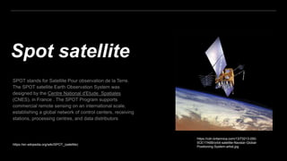
SPOT satellites are French Earth observation satellites operated by Spot Image. The first SPOT satellite was launched in 1986 and was designed to acquire images of Earth's surface for use in fields like agriculture, cartography, geology and forestry. SPOT satellites provide high-resolution panchromatic and multispectral imagery to commercial customers and scientific researchers around the world.
Report
Share
Report
Share

Recommended
Landsat
Landsat was a joint NASA/USGS satellite program designed to systematically acquire global land surface images. Landsat 1 was launched in 1972 as the first satellite dedicated to observing Earth's land areas. Subsequent Landsat satellites carried improved sensors with higher spatial, spectral, and radiometric resolutions. Landsat provides repetitive coverage of the entire global land mass with images useful for mapping and monitoring land use change over time.
Indian remote sensing satellites
Indian remote sensing satellites past and future launches with payloads. operational RS satellites detail.
SPOT
The SPOT satellite system includes several satellites (SPOT 1-5) operated by France and Belgium to observe and monitor Earth. Key specifications of the SPOT satellites include their launch dates between 1986-2002 using Ariane rockets, orbital parameters, onboard instruments including high-resolution visible and infrared cameras, recording and transmission capabilities, and inclusion of vegetation monitoring instruments on some satellites. The SPOT satellites provide high-resolution optical imagery of Earth to study resources, climate, human activities and natural phenomena.
Ikonos
The IKONOS satellite was launched in 1999 and has an operational life of over 7 years. It captures high resolution imagery with 0.82m panchromatic and 3.2m multispectral resolution. Its applications include mapping natural resources, disasters, agriculture, and it provides imagery for security, coastal monitoring, and 3D terrain analysis.
Introduction to Landsat
Landsat is a series of Earth observation satellite missions jointly managed by NASA and the U.S. Geological Survey. The first Landsat satellite was launched in 1972 and subsequent satellites were launched through 2013 to acquire global land data. Landsat satellites carry imaging sensors to collect medium-resolution multi-spectral images of the Earth's surface on a 16-day repeat cycle. The images are used to observe changes in land use, monitor deforestation, and detect water pollution among other applications. Six Landsat satellites have been launched to date, each carrying improved sensors from the Multi-Spectral Scanner to the Enhanced Thematic Mapper Plus. Landsat provides the longest continuous space-based record of Earth's surface.
Remote sensing-presentaion
This document discusses satellite remote sensing. It provides details on different types of remote sensing satellites including Landsat, MODIS, SPOT, IRS series, and IKONOS. It also describes various sensors used in remote sensing such as MSS, TM, HRV, LISS, PAN, and WiFS. The document discusses the basic principles, components, and applications of remote sensing from satellites for land resources survey, environmental monitoring, and other purposes.
GIS Plateform and satellite
Remote sensing platforms can be satellites or aircraft that carry sensors to record wavelengths of energy reflected or emitted from the Earth's surface. Common satellite platforms include Landsat and SPOT, which have multispectral sensors that image the surface at spatial resolutions from 5-80 meters. Satellite orbits vary depending on the purpose, and include low Earth, sun-synchronous, and geostationary orbits. Near-polar orbiting satellites have orbits that cross the poles and combine with the Earth's rotation to provide global coverage over time. Remote sensing provides valuable data for applications in civil engineering and other fields.
Remote sensing
The document discusses the four types of image resolution: spatial, spectral, radiometric, and temporal resolution. Spatial resolution refers to the ability of a sensor to identify the smallest details visible in an image. Spectral resolution is the sensor's ability to distinguish between narrow wavelength bands, while radiometric resolution refers to its ability to detect small differences in energy levels. Temporal resolution describes how frequently data is captured for a given location. Higher resolution in all four types provides more detailed, clear images for analysis.
Multispectral remote sensing
Multispectral remote sensing involves collecting reflected, emitted, and backscattered energy from objects in multiple bands of the electromagnetic spectrum simultaneously. There are three main types of multispectral sensor systems: line detectors that detect one object at a time; whiskbroom/cross-track sensors that use a rotating mirror to scan the surface; and pushbroom/along-track sensors that have no moving parts and sense energy directly using arrays of detectors. Multispectral remote sensing has applications in military intelligence gathering, medical imaging, land assessment, and studying seasonal variations.
Concept of gps
The Global Positioning System (GPS) uses satellites and receivers to locate positions on Earth. GPS satellites continuously transmit radio signals that are used by receivers to calculate their position using trilateration. The GPS system consists of space, control, and user segments - with satellites in space transmitting signals, control stations monitoring the satellites and sending corrections, and users employing receivers. A receiver needs signals from at least three satellites to determine a two-dimensional position, and four or more for greater accuracy.
Spot satellite
SPOT satellites provide medium to high resolution images of Earth's surface. There have been four SPOT satellites launched since 1986, each carrying multi-spectral and panchromatic sensors. SPOT satellites orbit at an altitude of 822km, with scenes sizes of 60km by 60km or 60km by 80km. Imaging is performed in three spectral bands - green, red, and near infrared - which can be combined to produce color composite images with 20m resolution. Receiving stations in Toulouse, France and Kiruna, Sweden download telemetry from the satellites.
Geo synchronous and Sun synchronous Satellites
There are three main types of satellite orbits:
1) Polar orbits have an inclination of 90 degrees, allowing satellites to observe the entire Earth as it rotates. They complete an orbit every 90 minutes.
2) Sun synchronous orbits allow satellites to pass over the same location at the same local time each day. These orbits are between 700-800 km in altitude.
3) Geosynchronous orbits circle the Earth at the same rate it rotates, allowing satellites to continuously observe nearly half of the Earth. These orbits are used for weather monitoring and communication satellites. Each orbit type has advantages and disadvantages for different applications.
Types of scanners
The document discusses different types of scanning systems used to collect remote sensing data. It describes whiskbroom scanners that use rotating mirrors to scan perpendicular to the flight path, building up images line-by-line. Pushbroom scanners use linear detector arrays that collect entire lines of pixels simultaneously as the sensor moves. Circular scanners employ rotating mirrors to scan in circular patterns, while side-scanning uses active radar to illuminate terrain to one side of the flight path. The characteristics of Landsat, SPOT, and sensor technologies are also overviewed.
Indian Satellite Program(2001-2020)
Indian Satellite Program (2001-2020)
India has developed an extensive satellite program over the past two decades focused on earth observation, communication, space science, and navigation. Key satellites include resources satellites to monitor land and water resources, radar satellites like RISAT for all-weather imaging, Cartosat satellites for mapping applications, Oceansat for ocean and atmospheric monitoring, space science satellites like Chandrayaan and Astrosat, and navigation satellites. The program is led by ISRO and has supported applications in agriculture, disaster management, and development planning.
Indian Remote Sensing satellites (IRS).pptx
Indian Remote Sensing satellites (IRS) are a series of Earth observation satellites built and operated by the Indian Space Research Organisation to provide remote sensing services. With twelve satellites currently in operation, IRS has the largest civilian remote sensing constellation providing imagery with various spatial resolutions and spectral bands. The satellite data is used for applications like agriculture, urban development, disaster management, and more. Key satellites discussed include IRS-1A, IRS-1B, IRS-1C, RISAT-1, Resourcesat-2, and Cartosat-2B.
Types of satellite metrological & resource satellites
The document discusses different types of satellites used for remote sensing including earth resource satellites, Landsat series satellites, SPOT satellites, Indian remote sensing satellites, IKONOS, meteorological/weather satellites like NOAA and GOES, and Indian national satellites like INSAT. It provides details on the sensors, spectral and spatial resolution, swath width, orbital altitude, and launch period of these various satellite systems used for monitoring earth's resources, weather, environment and climate.
Application of Basic Remote Sensing in Geology
Application of basic remote sensing in Geology. This presentation tries to discriminate the lithology in the Landsat-7 scene located Karachi West. Although other enhanced methodology available to discriminate the rock types, here just a band ratios and simple band combination used for lithology identification.
Remote sensing & gis
Geographic information systems (GIS) are organized collections of computer hardware, software, and geographic data used to capture, store, update, manipulate, analyze, and display geographically referenced information. GIS provides spatial data depicted as points, lines, or polygons with attributes stored in tables, and can take data from various sources and integrate them into multiple layers for analysis. Common applications of GIS include agriculture, natural resource management, disaster management, and urban planning.
Remote sensing
Remote sensing is the process of detecting and monitoring the physical characteristics of an area by measuring its reflected and emitted radiation at a distance using aircraft or satellites. It involves the acquisition of imagery and geospatial data through the analysis of electromagnetic radiation emitted or reflected from objects such as the Earth's surface. Some key advantages of remote sensing include its ability to provide cost-effective data collection over large or inaccessible areas and to monitor changes over time. Common applications include land use mapping, agriculture, forestry, geology and natural disaster monitoring.
Remote Sensing Platforms and Sensors
This document discusses remote sensing platforms and sensors. It describes the different types of orbits used by remote sensing satellites, including low Earth orbit, sun synchronous orbit, and geostationary orbit. It also outlines the various platforms that can be used, such as ground-based, airborne, and space-borne. Finally, it examines the characteristics of remote sensing sensors, including spatial, spectral, radiometric, and temporal resolution.
Image interpretation keys & image resolution
Image interpretation keys and resolutions are essential for remote sensing. There are several keys that aid visual interpretation including tone, size, shape, texture, pattern, location, association, shadow and site. Higher image resolution means more discernible details, with pixel resolution referring to image size in pixels and spatial resolution depending on ground sample distance. Other types of resolutions include spectral, temporal, and radiometric resolutions which influence how finely differences can be distinguished.
Microwave remote sensing
Basic Concepts, Explanation, and Application. Fundamental Remote Sensing; Advantage/ disadvantages, Imaging/non Imaging sensors, RAR and SAR, SAR Geometry, Resolutions in the microwave, Geometric Distortions in SAR, Polarization in SAR, Target Interaction, SAR Interferometry
Optical remote sensing
Optical remote sensing uses visible, near infrared, and shortwave infrared sensors to form images of the Earth's surface by detecting solar radiation reflected from targets. Different materials reflect and absorb light differently at different wavelengths, allowing targets to be differentiated by their spectral signatures. Optical remote sensing systems are classified as panchromatic, multispectral, hyperspectral, or superspectral depending on the number of spectral bands measured.
Basics of Remote Sensing
Remote sensing involves obtaining information about objects without physical contact. It works by sensing and recording electromagnetic radiation reflected or emitted from targets. The key components are an energy source, sensor, platforms, and data analysis to extract information. Sensors can be optical, thermal, or microwave. Platforms include satellites, aircraft, and ground bases. Applications of remote sensing include agriculture, forestry, geology, hydrology, urban planning, and national security.
Stereoscopic Parallax
In this I have discussed how to estimate height of an object from aerial photo and steps to make a stereo pair
SENSORS AND SCANNERS.pptx
Sensors and scanners can be categorized based on their energy source and detection method. The key types are active sensors that emit their own energy and passive sensors that detect existing energy sources like sunlight. Sensors have various resolutions that determine their capabilities. Imaging sensors like multispectral scanners use arrays of detectors to capture images across spectral bands either along or across their flight path. Thermal sensors detect infrared radiation, while hyperspectral sensors provide continuous spectral signatures through hundreds of contiguous bands.
mateorological and ocean monitoring satellite (2).pptx
This document summarizes meteorological and ocean monitoring satellites. It discusses the main types of meteorological satellites including geostationary and polar-orbiting satellites. It provides details on specific meteorological satellite programs run by countries and organizations like the US, Europe, India, and Japan. These include NOAA, GOES, Meteosat, Nimbus, Megha-Tropiques, and INSAT satellites. The document also describes the common sensors and image types used by these satellites like AVHRR, TOVS, and visible, infrared, water vapor images. It explains the features and uses of these different sensor images.
ANATOMY AND BIOMECHANICS OF HIP JOINT.pdf
it describes the bony anatomy including the femoral head , acetabulum, labrum . also discusses the capsule , ligaments . muscle that act on the hip joint and the range of motion are outlined. factors affecting hip joint stability and weight transmission through the joint are summarized.
South African Journal of Science: Writing with integrity workshop (2024)
South African Journal of Science: Writing with integrity workshop (2024)Academy of Science of South Africa
A workshop hosted by the South African Journal of Science aimed at postgraduate students and early career researchers with little or no experience in writing and publishing journal articles.More Related Content
What's hot
Multispectral remote sensing
Multispectral remote sensing involves collecting reflected, emitted, and backscattered energy from objects in multiple bands of the electromagnetic spectrum simultaneously. There are three main types of multispectral sensor systems: line detectors that detect one object at a time; whiskbroom/cross-track sensors that use a rotating mirror to scan the surface; and pushbroom/along-track sensors that have no moving parts and sense energy directly using arrays of detectors. Multispectral remote sensing has applications in military intelligence gathering, medical imaging, land assessment, and studying seasonal variations.
Concept of gps
The Global Positioning System (GPS) uses satellites and receivers to locate positions on Earth. GPS satellites continuously transmit radio signals that are used by receivers to calculate their position using trilateration. The GPS system consists of space, control, and user segments - with satellites in space transmitting signals, control stations monitoring the satellites and sending corrections, and users employing receivers. A receiver needs signals from at least three satellites to determine a two-dimensional position, and four or more for greater accuracy.
Spot satellite
SPOT satellites provide medium to high resolution images of Earth's surface. There have been four SPOT satellites launched since 1986, each carrying multi-spectral and panchromatic sensors. SPOT satellites orbit at an altitude of 822km, with scenes sizes of 60km by 60km or 60km by 80km. Imaging is performed in three spectral bands - green, red, and near infrared - which can be combined to produce color composite images with 20m resolution. Receiving stations in Toulouse, France and Kiruna, Sweden download telemetry from the satellites.
Geo synchronous and Sun synchronous Satellites
There are three main types of satellite orbits:
1) Polar orbits have an inclination of 90 degrees, allowing satellites to observe the entire Earth as it rotates. They complete an orbit every 90 minutes.
2) Sun synchronous orbits allow satellites to pass over the same location at the same local time each day. These orbits are between 700-800 km in altitude.
3) Geosynchronous orbits circle the Earth at the same rate it rotates, allowing satellites to continuously observe nearly half of the Earth. These orbits are used for weather monitoring and communication satellites. Each orbit type has advantages and disadvantages for different applications.
Types of scanners
The document discusses different types of scanning systems used to collect remote sensing data. It describes whiskbroom scanners that use rotating mirrors to scan perpendicular to the flight path, building up images line-by-line. Pushbroom scanners use linear detector arrays that collect entire lines of pixels simultaneously as the sensor moves. Circular scanners employ rotating mirrors to scan in circular patterns, while side-scanning uses active radar to illuminate terrain to one side of the flight path. The characteristics of Landsat, SPOT, and sensor technologies are also overviewed.
Indian Satellite Program(2001-2020)
Indian Satellite Program (2001-2020)
India has developed an extensive satellite program over the past two decades focused on earth observation, communication, space science, and navigation. Key satellites include resources satellites to monitor land and water resources, radar satellites like RISAT for all-weather imaging, Cartosat satellites for mapping applications, Oceansat for ocean and atmospheric monitoring, space science satellites like Chandrayaan and Astrosat, and navigation satellites. The program is led by ISRO and has supported applications in agriculture, disaster management, and development planning.
Indian Remote Sensing satellites (IRS).pptx
Indian Remote Sensing satellites (IRS) are a series of Earth observation satellites built and operated by the Indian Space Research Organisation to provide remote sensing services. With twelve satellites currently in operation, IRS has the largest civilian remote sensing constellation providing imagery with various spatial resolutions and spectral bands. The satellite data is used for applications like agriculture, urban development, disaster management, and more. Key satellites discussed include IRS-1A, IRS-1B, IRS-1C, RISAT-1, Resourcesat-2, and Cartosat-2B.
Types of satellite metrological & resource satellites
The document discusses different types of satellites used for remote sensing including earth resource satellites, Landsat series satellites, SPOT satellites, Indian remote sensing satellites, IKONOS, meteorological/weather satellites like NOAA and GOES, and Indian national satellites like INSAT. It provides details on the sensors, spectral and spatial resolution, swath width, orbital altitude, and launch period of these various satellite systems used for monitoring earth's resources, weather, environment and climate.
Application of Basic Remote Sensing in Geology
Application of basic remote sensing in Geology. This presentation tries to discriminate the lithology in the Landsat-7 scene located Karachi West. Although other enhanced methodology available to discriminate the rock types, here just a band ratios and simple band combination used for lithology identification.
Remote sensing & gis
Geographic information systems (GIS) are organized collections of computer hardware, software, and geographic data used to capture, store, update, manipulate, analyze, and display geographically referenced information. GIS provides spatial data depicted as points, lines, or polygons with attributes stored in tables, and can take data from various sources and integrate them into multiple layers for analysis. Common applications of GIS include agriculture, natural resource management, disaster management, and urban planning.
Remote sensing
Remote sensing is the process of detecting and monitoring the physical characteristics of an area by measuring its reflected and emitted radiation at a distance using aircraft or satellites. It involves the acquisition of imagery and geospatial data through the analysis of electromagnetic radiation emitted or reflected from objects such as the Earth's surface. Some key advantages of remote sensing include its ability to provide cost-effective data collection over large or inaccessible areas and to monitor changes over time. Common applications include land use mapping, agriculture, forestry, geology and natural disaster monitoring.
Remote Sensing Platforms and Sensors
This document discusses remote sensing platforms and sensors. It describes the different types of orbits used by remote sensing satellites, including low Earth orbit, sun synchronous orbit, and geostationary orbit. It also outlines the various platforms that can be used, such as ground-based, airborne, and space-borne. Finally, it examines the characteristics of remote sensing sensors, including spatial, spectral, radiometric, and temporal resolution.
Image interpretation keys & image resolution
Image interpretation keys and resolutions are essential for remote sensing. There are several keys that aid visual interpretation including tone, size, shape, texture, pattern, location, association, shadow and site. Higher image resolution means more discernible details, with pixel resolution referring to image size in pixels and spatial resolution depending on ground sample distance. Other types of resolutions include spectral, temporal, and radiometric resolutions which influence how finely differences can be distinguished.
Microwave remote sensing
Basic Concepts, Explanation, and Application. Fundamental Remote Sensing; Advantage/ disadvantages, Imaging/non Imaging sensors, RAR and SAR, SAR Geometry, Resolutions in the microwave, Geometric Distortions in SAR, Polarization in SAR, Target Interaction, SAR Interferometry
Optical remote sensing
Optical remote sensing uses visible, near infrared, and shortwave infrared sensors to form images of the Earth's surface by detecting solar radiation reflected from targets. Different materials reflect and absorb light differently at different wavelengths, allowing targets to be differentiated by their spectral signatures. Optical remote sensing systems are classified as panchromatic, multispectral, hyperspectral, or superspectral depending on the number of spectral bands measured.
Basics of Remote Sensing
Remote sensing involves obtaining information about objects without physical contact. It works by sensing and recording electromagnetic radiation reflected or emitted from targets. The key components are an energy source, sensor, platforms, and data analysis to extract information. Sensors can be optical, thermal, or microwave. Platforms include satellites, aircraft, and ground bases. Applications of remote sensing include agriculture, forestry, geology, hydrology, urban planning, and national security.
Stereoscopic Parallax
In this I have discussed how to estimate height of an object from aerial photo and steps to make a stereo pair
SENSORS AND SCANNERS.pptx
Sensors and scanners can be categorized based on their energy source and detection method. The key types are active sensors that emit their own energy and passive sensors that detect existing energy sources like sunlight. Sensors have various resolutions that determine their capabilities. Imaging sensors like multispectral scanners use arrays of detectors to capture images across spectral bands either along or across their flight path. Thermal sensors detect infrared radiation, while hyperspectral sensors provide continuous spectral signatures through hundreds of contiguous bands.
mateorological and ocean monitoring satellite (2).pptx
This document summarizes meteorological and ocean monitoring satellites. It discusses the main types of meteorological satellites including geostationary and polar-orbiting satellites. It provides details on specific meteorological satellite programs run by countries and organizations like the US, Europe, India, and Japan. These include NOAA, GOES, Meteosat, Nimbus, Megha-Tropiques, and INSAT satellites. The document also describes the common sensors and image types used by these satellites like AVHRR, TOVS, and visible, infrared, water vapor images. It explains the features and uses of these different sensor images.
What's hot (20)
Types of satellite metrological & resource satellites
Types of satellite metrological & resource satellites
mateorological and ocean monitoring satellite (2).pptx
mateorological and ocean monitoring satellite (2).pptx
Recently uploaded
ANATOMY AND BIOMECHANICS OF HIP JOINT.pdf
it describes the bony anatomy including the femoral head , acetabulum, labrum . also discusses the capsule , ligaments . muscle that act on the hip joint and the range of motion are outlined. factors affecting hip joint stability and weight transmission through the joint are summarized.
South African Journal of Science: Writing with integrity workshop (2024)
South African Journal of Science: Writing with integrity workshop (2024)Academy of Science of South Africa
A workshop hosted by the South African Journal of Science aimed at postgraduate students and early career researchers with little or no experience in writing and publishing journal articles.DRUGS AND ITS classification slide share
Any substance (other than food) that is used to prevent, diagnose, treat, or relieve symptoms of a
disease or abnormal condition
Azure Interview Questions and Answers PDF By ScholarHat
Azure Interview Questions and Answers PDF By ScholarHat
A Strategic Approach: GenAI in Education
Artificial Intelligence (AI) technologies such as Generative AI, Image Generators and Large Language Models have had a dramatic impact on teaching, learning and assessment over the past 18 months. The most immediate threat AI posed was to Academic Integrity with Higher Education Institutes (HEIs) focusing their efforts on combating the use of GenAI in assessment. Guidelines were developed for staff and students, policies put in place too. Innovative educators have forged paths in the use of Generative AI for teaching, learning and assessments leading to pockets of transformation springing up across HEIs, often with little or no top-down guidance, support or direction.
This Gasta posits a strategic approach to integrating AI into HEIs to prepare staff, students and the curriculum for an evolving world and workplace. We will highlight the advantages of working with these technologies beyond the realm of teaching, learning and assessment by considering prompt engineering skills, industry impact, curriculum changes, and the need for staff upskilling. In contrast, not engaging strategically with Generative AI poses risks, including falling behind peers, missed opportunities and failing to ensure our graduates remain employable. The rapid evolution of AI technologies necessitates a proactive and strategic approach if we are to remain relevant.
Pollock and Snow "DEIA in the Scholarly Landscape, Session One: Setting Expec...
Pollock and Snow "DEIA in the Scholarly Landscape, Session One: Setting Expec...National Information Standards Organization (NISO)
This presentation was provided by Steph Pollock of The American Psychological Association’s Journals Program, and Damita Snow, of The American Society of Civil Engineers (ASCE), for the initial session of NISO's 2024 Training Series "DEIA in the Scholarly Landscape." Session One: 'Setting Expectations: a DEIA Primer,' was held June 6, 2024.Types of Herbal Cosmetics its standardization.
Physiology and chemistry of skin and pigmentation, hairs, scalp, lips and nail, Cleansing cream, Lotions, Face powders, Face packs, Lipsticks, Bath products, soaps and baby product,
Preparation and standardization of the following : Tonic, Bleaches, Dentifrices and Mouth washes & Tooth Pastes, Cosmetics for Nails.
Digital Artifact 1 - 10VCD Environments Unit
Digital Artifact 1 - 10VCD Environments Unit - NGV Pavilion Concept Design
Advanced Java[Extra Concepts, Not Difficult].docx
This is part 2 of my Java Learning Journey. This contains Hashing, ArrayList, LinkedList, Date and Time Classes, Calendar Class and more.
How to Add Chatter in the odoo 17 ERP Module
In Odoo, the chatter is like a chat tool that helps you work together on records. You can leave notes and track things, making it easier to talk with your team and partners. Inside chatter, all communication history, activity, and changes will be displayed.
Main Java[All of the Base Concepts}.docx
This is part 1 of my Java Learning Journey. This Contains Custom methods, classes, constructors, packages, multithreading , try- catch block, finally block and more.
ISO/IEC 27001, ISO/IEC 42001, and GDPR: Best Practices for Implementation and...
Denis is a dynamic and results-driven Chief Information Officer (CIO) with a distinguished career spanning information systems analysis and technical project management. With a proven track record of spearheading the design and delivery of cutting-edge Information Management solutions, he has consistently elevated business operations, streamlined reporting functions, and maximized process efficiency.
Certified as an ISO/IEC 27001: Information Security Management Systems (ISMS) Lead Implementer, Data Protection Officer, and Cyber Risks Analyst, Denis brings a heightened focus on data security, privacy, and cyber resilience to every endeavor.
His expertise extends across a diverse spectrum of reporting, database, and web development applications, underpinned by an exceptional grasp of data storage and virtualization technologies. His proficiency in application testing, database administration, and data cleansing ensures seamless execution of complex projects.
What sets Denis apart is his comprehensive understanding of Business and Systems Analysis technologies, honed through involvement in all phases of the Software Development Lifecycle (SDLC). From meticulous requirements gathering to precise analysis, innovative design, rigorous development, thorough testing, and successful implementation, he has consistently delivered exceptional results.
Throughout his career, he has taken on multifaceted roles, from leading technical project management teams to owning solutions that drive operational excellence. His conscientious and proactive approach is unwavering, whether he is working independently or collaboratively within a team. His ability to connect with colleagues on a personal level underscores his commitment to fostering a harmonious and productive workplace environment.
Date: May 29, 2024
Tags: Information Security, ISO/IEC 27001, ISO/IEC 42001, Artificial Intelligence, GDPR
-------------------------------------------------------------------------------
Find out more about ISO training and certification services
Training: ISO/IEC 27001 Information Security Management System - EN | PECB
ISO/IEC 42001 Artificial Intelligence Management System - EN | PECB
General Data Protection Regulation (GDPR) - Training Courses - EN | PECB
Webinars: https://pecb.com/webinars
Article: https://pecb.com/article
-------------------------------------------------------------------------------
For more information about PECB:
Website: https://pecb.com/
LinkedIn: https://www.linkedin.com/company/pecb/
Facebook: https://www.facebook.com/PECBInternational/
Slideshare: http://www.slideshare.net/PECBCERTIFICATION
BÀI TẬP BỔ TRỢ TIẾNG ANH 8 CẢ NĂM - GLOBAL SUCCESS - NĂM HỌC 2023-2024 (CÓ FI...
BÀI TẬP BỔ TRỢ TIẾNG ANH 8 CẢ NĂM - GLOBAL SUCCESS - NĂM HỌC 2023-2024 (CÓ FI...Nguyen Thanh Tu Collection
https://app.box.com/s/y977uz6bpd3af4qsebv7r9b7s21935vdExploiting Artificial Intelligence for Empowering Researchers and Faculty, In...
Exploiting Artificial Intelligence for Empowering Researchers and Faculty, In...Dr. Vinod Kumar Kanvaria
Exploiting Artificial Intelligence for Empowering Researchers and Faculty,
International FDP on Fundamentals of Research in Social Sciences
at Integral University, Lucknow, 06.06.2024
By Dr. Vinod Kumar KanvariaRecently uploaded (20)
South African Journal of Science: Writing with integrity workshop (2024)
South African Journal of Science: Writing with integrity workshop (2024)
Liberal Approach to the Study of Indian Politics.pdf
Liberal Approach to the Study of Indian Politics.pdf
Azure Interview Questions and Answers PDF By ScholarHat
Azure Interview Questions and Answers PDF By ScholarHat
Pollock and Snow "DEIA in the Scholarly Landscape, Session One: Setting Expec...
Pollock and Snow "DEIA in the Scholarly Landscape, Session One: Setting Expec...
Pride Month Slides 2024 David Douglas School District
Pride Month Slides 2024 David Douglas School District
ISO/IEC 27001, ISO/IEC 42001, and GDPR: Best Practices for Implementation and...
ISO/IEC 27001, ISO/IEC 42001, and GDPR: Best Practices for Implementation and...
BÀI TẬP BỔ TRỢ TIẾNG ANH 8 CẢ NĂM - GLOBAL SUCCESS - NĂM HỌC 2023-2024 (CÓ FI...
BÀI TẬP BỔ TRỢ TIẾNG ANH 8 CẢ NĂM - GLOBAL SUCCESS - NĂM HỌC 2023-2024 (CÓ FI...
Film vocab for eal 3 students: Australia the movie
Film vocab for eal 3 students: Australia the movie
Exploiting Artificial Intelligence for Empowering Researchers and Faculty, In...
Exploiting Artificial Intelligence for Empowering Researchers and Faculty, In...