Downloaded 10 times


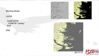
![09/17/15
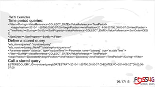
HTML Legend examples
JSON formatted: [leg_class_html opt_flag=0]
{"name": "[leg_class_name]", "icon": "[leg_icon]", "mykey" : "myvalue" },
[/leg_class_html]
HTML formatted: [leg_class_html opt_flag=0]
<img src=[leg_icon]> [leg_class_name]<br>
[/leg_class_html]](https://image.slidesharecdn.com/mapserver-protips-2015-150928234815-lva1-app6892/85/MapServer-ProTips-2015-20-320.jpg)


The document provides a collection of tips for power users of MapServer to optimize their mapping workflow, focusing on debugging strategies, securing services, and utilizing features such as projection auto and WFS 2.0. It covers advanced techniques for performance tracking, HTML-based legends, content-dependent legends, and new blending modes introduced in version 7.0. Additional examples and command line utilities are also referenced to enhance user experience and performance in MapServer.