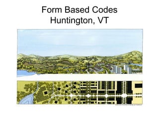
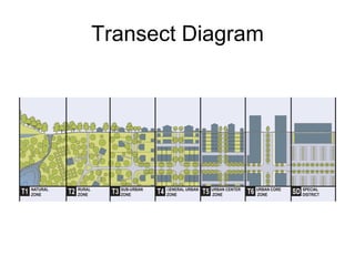
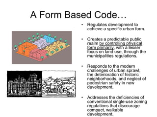
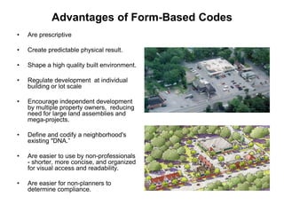
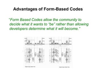
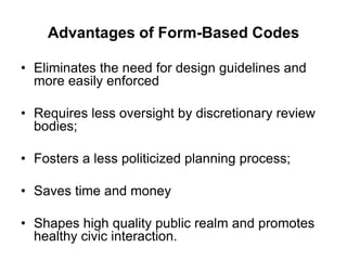
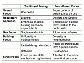
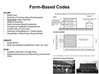
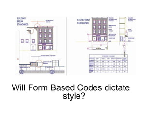
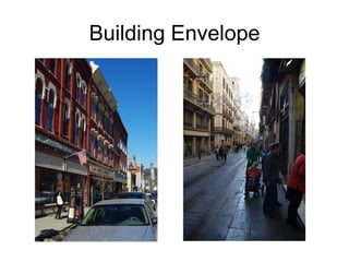
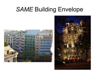
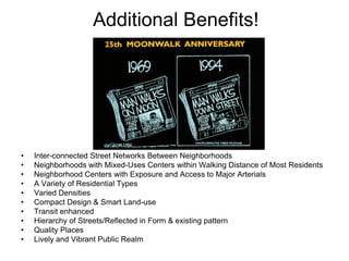
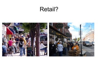
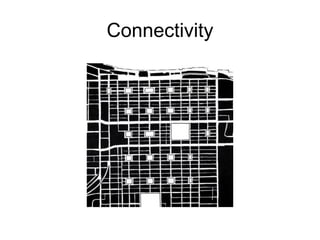
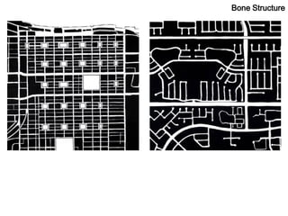
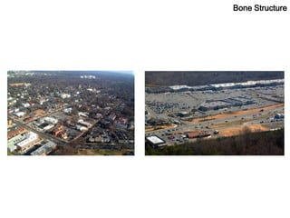
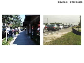
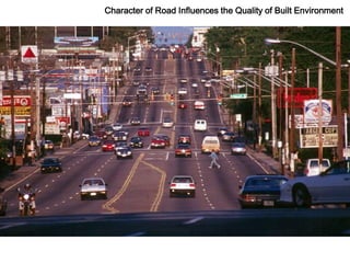
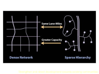
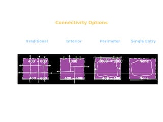
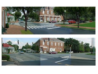
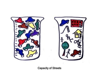
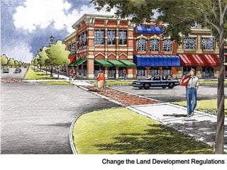
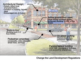
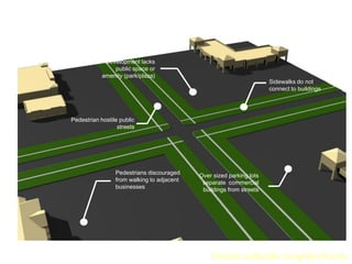
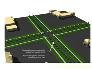
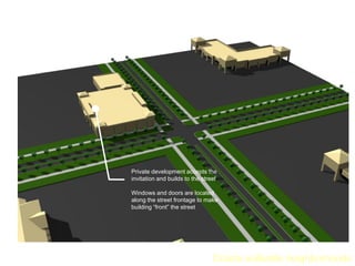
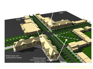
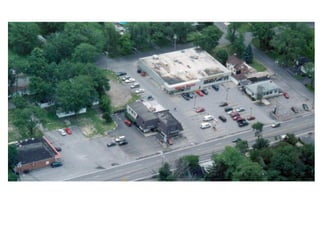
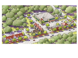
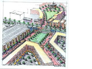
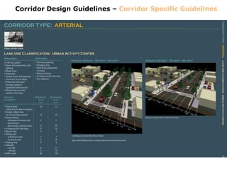
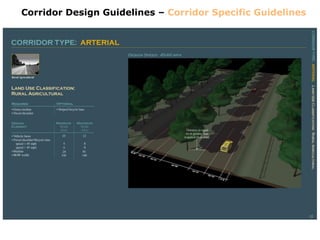
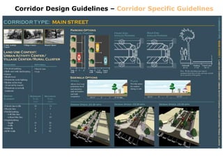
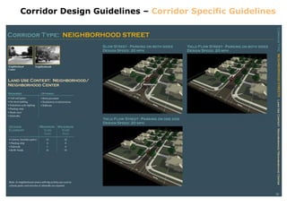
Form Based Codes
  Huntington, VT
Transect Diagram
A Form Based Code…
         • Regulates development to
           achieve a specific urban form.

         • Creates a predictable public
           realm by controlling physical
           form primarily, with a lesser
           focus on land use, through the
           municipalities regulations.

         • Responds to the modern
           challenges of urban sprawl,
           the deterioration of historic
           neighborhoods, and neglect of
           pedestrian safety in new
           development.

         • Addresses the deficiencies of
           conventional single-use zoning
           regulations that discourage
           compact, walkable
           development.
Advantages of Form-Based Codes
•   Are prescriptive

•   Create predictable physical result.

•   Shape a high quality built environment.

•   Regulate development at individual
    building or lot scale

•   Encourage independent development
    by multiple property owners, reducing
    need for large land assemblies and
    mega-projects.

•   Define and codify a neighborhood's
    existing "DNA.”

•   Are easier to use by non-professionals
    - shorter, more concise, and organized
    for visual access and readability.

•   Are easier for non-planners to
    determine compliance.
Advantages of Form-Based Codes

“Form Based Codes allow the community to
decide what it wants to “be” rather than allowing
developers determine what it will become.”
Advantages of Form-Based Codes

• Eliminates the need for design guidelines and
  more easily enforced

• Requires less oversight by discretionary review
  bodies;

• Fosters a less politicized planning process;

• Saves time and money

• Shapes high quality public realm and promotes
  healthy civic interaction.
Traditional Zoning       Form-Based Codes
Overall                                  Focus on form of
               Use-based
Focus                                    building, less on use
Regulatory     Districts                 Districts and Streets
Approach       Emphasis on uses;         Emphasis on building
               building placement        form; relation to the
               unpredictable             public realm
Use Focus      Single use districts      Allows a mix of uses
Building       Uniformity in             Diversity in
Focus          neighborhoods             neighborhoods
                                        Focus on architectural
               Limited design standards
                                        form & public spaces
               Setbacks                  Build to lines
               Focus on site - little   Attention to the public
Street Focus
               emphasis on right-of-way realm & streetscape
Form-Based Codes
ALLOW
•  Mixed uses
•  Diversity of housing options/housing types
•  Moderately higher densities
•  Street connectivity
•  Multi-functional streets/boulevards
•  Compact and walkable neighborhoods
•  Creative Mix of Land Uses
•  Hierarchy of Roadways to Create Places
•  Residential or Mixed-Uses Along Arterials


CREATE
•  Great places
•  Multi-use roadways (pedestrians, bike, car, bus)

STOP
•  Isolated Land Uses in Single Pods
•  Maximizing Revenues by Maximizing Commercial
   Uses
Will Form Based Codes dictate
            style?
Building Envelope
SAME Building Envelope
Additional Benefits!


•   Inter-connected Street Networks Between Neighborhoods
•   Neighborhoods with Mixed-Uses Centers within Walking Distance of Most Residents
•   Neighborhood Centers with Exposure and Access to Major Arterials
•   A Variety of Residential Types
•   Varied Densities
•   Compact Design & Smart Land-use
•   Transit enhanced
•   Hierarchy of Streets/Reflected in Form & existing pattern
•   Quality Places
•   Lively and Vibrant Public Realm
Retail?
Connectivity
Understanding the Transportation and Land Use Relationship


                 The advent of the highway system . . .
Understanding the Transportation and Land Use Relationship


  . . . moved the form of development from the pedestrian to the automobile.
Bone Structure
Bone Structure
The Bone Structure – Streetscape
Transportation / Land Use
         Connection
The Size and Character of Road Influences the Quality of Built Environment
Quality
Of
Life


     High Standard of Living
Low Quality of Life
Transportation Investment Change Land Use Patterns
Overcoming
The Fear
Of Change


The problems we
have created cannot be
solved with the same
thinking that created them …
No Network – BIG ROADS
Connected Network – SMALL ROADS
Providing capacity through roadway networks


Strengthen and direct development towards existing communities
Connectivity Options


Traditional        Interior    Perimeter       Single Entry


400’ – 600’         1000’      1000’ – 2000’      None


 400 – 600        400 – 600     400 – 600         None


 All Streets      Connectors    Connectors        (No
  Fronted          Fronted        Walled       Connection)
Capacity of Streets
Change the Land Development Regulations
Architectural Design:
• Details reflect local
  character/history
• Variation in massing, façade,
  bays
• Encouraged min. 2-3 story

                                               Active ground-floor uses:
                                               (large display windows, public
                                               entrances, Building “fronts” on the
                                               street)


                                                          On-street parking
                                                          (Makes street more
      Pedestrian amenities:                               pedestrian friendly)
      (crosswalks, wide sidewalks,
      street trees, awnings)

                                                Parking behind building
                                                (With max. standards to limit size
                                                and account for shared use)


                                     Change the Land Development Regulations
Orient building to the street
                    Transit service ineffective
                    (Buildings too far from street,)


             Development lacks
                public space or
            amenity (park/plaza)
                                                                             Sidewalks do not
                                                                             connect to buildings


Pedestrian hostile public
                  streets


                 Pedestrians discouraged           Over sized parking lots
                 from walking to adjacent           separate commercial
                 businesses                         buildings from streets


                                                       Create walkable neighborhoods
Orient building to the street


Streetscape improvements invite
      pedestrians to public street

 Access management minimizes
       driveways and curb cuts


                                     Create walkable neighborhoods
Orient building to the street


Private development accepts the
invitation and builds to the street

Windows and doors are located
along the street frontage to make
building “front” the street


                                 Create walkable neighborhoods
Orient building to the street


                                                        New development
                                                        continues to build to the
                                                        street

 Density and location of
buildings support public
                  transit


• Shared “park once”
  environment is created        Public/private park
                            improvements create a
                                 valuable amenity


                                                      Create walkable neighborhoods
Corridor Design Guidelines – Corridor Specific Guidelines
Capacity of Streets
Signage
25th Moonwalk Anniversary

Form based codes huntington

  • 1.
    Form Based Codes Huntington, VT
  • 2.
  • 3.
    A Form BasedCode… • Regulates development to achieve a specific urban form. • Creates a predictable public realm by controlling physical form primarily, with a lesser focus on land use, through the municipalities regulations. • Responds to the modern challenges of urban sprawl, the deterioration of historic neighborhoods, and neglect of pedestrian safety in new development. • Addresses the deficiencies of conventional single-use zoning regulations that discourage compact, walkable development.
  • 4.
    Advantages of Form-BasedCodes • Are prescriptive • Create predictable physical result. • Shape a high quality built environment. • Regulate development at individual building or lot scale • Encourage independent development by multiple property owners, reducing need for large land assemblies and mega-projects. • Define and codify a neighborhood's existing "DNA.” • Are easier to use by non-professionals - shorter, more concise, and organized for visual access and readability. • Are easier for non-planners to determine compliance.
  • 5.
    Advantages of Form-BasedCodes “Form Based Codes allow the community to decide what it wants to “be” rather than allowing developers determine what it will become.”
  • 6.
    Advantages of Form-BasedCodes • Eliminates the need for design guidelines and more easily enforced • Requires less oversight by discretionary review bodies; • Fosters a less politicized planning process; • Saves time and money • Shapes high quality public realm and promotes healthy civic interaction.
  • 7.
    Traditional Zoning Form-Based Codes Overall Focus on form of Use-based Focus building, less on use Regulatory Districts Districts and Streets Approach Emphasis on uses; Emphasis on building building placement form; relation to the unpredictable public realm Use Focus Single use districts Allows a mix of uses Building Uniformity in Diversity in Focus neighborhoods neighborhoods Focus on architectural Limited design standards form & public spaces Setbacks Build to lines Focus on site - little Attention to the public Street Focus emphasis on right-of-way realm & streetscape
  • 8.
    Form-Based Codes ALLOW • Mixed uses • Diversity of housing options/housing types • Moderately higher densities • Street connectivity • Multi-functional streets/boulevards • Compact and walkable neighborhoods • Creative Mix of Land Uses • Hierarchy of Roadways to Create Places • Residential or Mixed-Uses Along Arterials CREATE • Great places • Multi-use roadways (pedestrians, bike, car, bus) STOP • Isolated Land Uses in Single Pods • Maximizing Revenues by Maximizing Commercial Uses
  • 9.
    Will Form BasedCodes dictate style?
  • 10.
  • 11.
  • 12.
    Additional Benefits! • Inter-connected Street Networks Between Neighborhoods • Neighborhoods with Mixed-Uses Centers within Walking Distance of Most Residents • Neighborhood Centers with Exposure and Access to Major Arterials • A Variety of Residential Types • Varied Densities • Compact Design & Smart Land-use • Transit enhanced • Hierarchy of Streets/Reflected in Form & existing pattern • Quality Places • Lively and Vibrant Public Realm
  • 13.
  • 14.
  • 21.
    Understanding the Transportationand Land Use Relationship The advent of the highway system . . .
  • 22.
    Understanding the Transportationand Land Use Relationship . . . moved the form of development from the pedestrian to the automobile.
  • 23.
  • 24.
  • 25.
    The Bone Structure– Streetscape
  • 26.
    Transportation / LandUse Connection
  • 27.
    The Size andCharacter of Road Influences the Quality of Built Environment
  • 28.
    Quality Of Life High Standard of Living
  • 29.
  • 30.
  • 31.
  • 32.
    Overcoming The Fear Of Change Theproblems we have created cannot be solved with the same thinking that created them …
  • 34.
    No Network –BIG ROADS
  • 35.
  • 36.
    Providing capacity throughroadway networks Strengthen and direct development towards existing communities
  • 37.
    Connectivity Options Traditional Interior Perimeter Single Entry 400’ – 600’ 1000’ 1000’ – 2000’ None 400 – 600 400 – 600 400 – 600 None All Streets Connectors Connectors (No Fronted Fronted Walled Connection)
  • 39.
  • 40.
    Change the LandDevelopment Regulations
  • 41.
    Architectural Design: • Detailsreflect local character/history • Variation in massing, façade, bays • Encouraged min. 2-3 story Active ground-floor uses: (large display windows, public entrances, Building “fronts” on the street) On-street parking (Makes street more Pedestrian amenities: pedestrian friendly) (crosswalks, wide sidewalks, street trees, awnings) Parking behind building (With max. standards to limit size and account for shared use) Change the Land Development Regulations
  • 42.
    Orient building tothe street Transit service ineffective (Buildings too far from street,) Development lacks public space or amenity (park/plaza) Sidewalks do not connect to buildings Pedestrian hostile public streets Pedestrians discouraged Over sized parking lots from walking to adjacent separate commercial businesses buildings from streets Create walkable neighborhoods
  • 43.
    Orient building tothe street Streetscape improvements invite pedestrians to public street Access management minimizes driveways and curb cuts Create walkable neighborhoods
  • 44.
    Orient building tothe street Private development accepts the invitation and builds to the street Windows and doors are located along the street frontage to make building “front” the street Create walkable neighborhoods
  • 45.
    Orient building tothe street New development continues to build to the street Density and location of buildings support public transit • Shared “park once” environment is created Public/private park improvements create a valuable amenity Create walkable neighborhoods
  • 49.
    Corridor Design Guidelines– Corridor Specific Guidelines
  • 50.
    Corridor Design Guidelines– Corridor Specific Guidelines
  • 51.
    Corridor Design Guidelines– Corridor Specific Guidelines
  • 52.
    Corridor Design Guidelines– Corridor Specific Guidelines
  • 53.
  • 54.
  • 55.