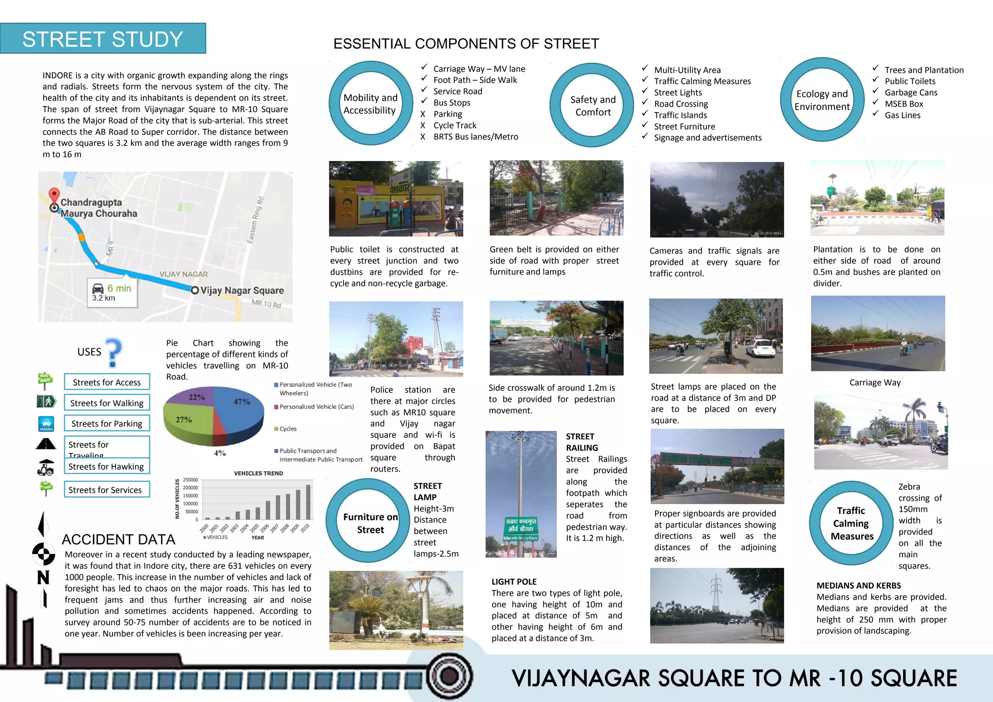
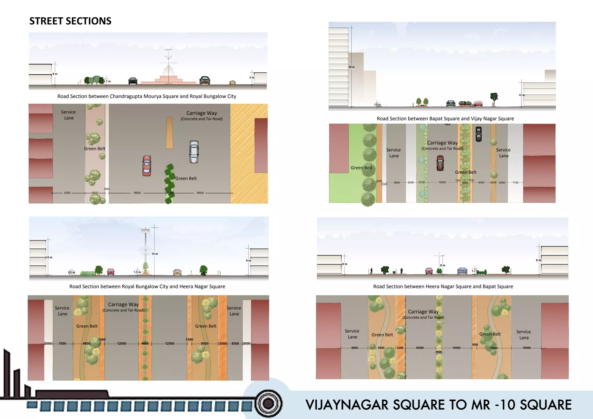
It's case study report of the street study of Indore's 5-star hotel sayaji main road, m.p.This work is done me and my colleagues in the academic semester.
Urban Design-Literature study St. Marks Road, BangaloreAnsh Agarwal
Urban Planning
Literature study of St. Marks Road, Bangalore.
Includes:
1. Road Details
2. Survey Details & Analysis
3. Action Needed
4. Proposals
5. Action Made
6. Before & After Scenerio
7. Anatomy of Changes
The case study is about the india's most well planned city that is Jaipur, Rajasthan. what is the urban sprawl in that city and how it grows that will expained in that.
INTRODUCTION
COORDINATES - 23.22 ON 72.680 E ELEVATION - 265 feet (81 m)*
LOCATED 23 KM NORTH OF AHEMDABAD (FIN CAP. OF GUJARAT)
PLANNED IN 1960S BY, PRAKASH M APTE & H. K. MEWADA,
AFTER PARTITION OF BOMBAY * STATE : AHEMDABAD WAS MADE AS THE CAPTAL OFGUJARAT
AREA TOTAL 177KM2 ELEVATION : 8IM ( 266 FT)
POPULATION (2011)
TOTAL: 206,167 DENSITY : 1,200/KM2
CLIMATE*
TROPICAL WET AND DRY CLIMATE•
SUMMER MAXIMUM - 36 to 42 °C MINIMUM - 19 to 27 C
WINTER MAXIMUM - 29 C MINIMUM - 14°C
MONSOON: THE AVERAGE ANNUAL RAINFALL IS AROUND 803.4 MM
LANGUAGES
GUJARATI, HINDI, AND ENGLISH• 54% GREEN COVER ON ITS LAND AREA
• THE CITY SITS ON THE BANKS OF THE SABARMATI RIVER, IN NORTH-CENTRALEAST GUJARAT
HISTORY
IN 1960, THE INDIAN STATE OF BOMBAY WAS SPLIT INTO TWO STATES, MAHARASHTRA AND GUJARAT LEAVING GUJARAT WITHOUT A CAPITAL CITY.
AT THE TIME AHMEDABAD WAS SELECTED TO BE THE FIRST CAPITAL OF THE NEWLY CREATED STATE.
• IT WAS LATER PROPOSED THAT A NEW CAPITAL CITY BE CONSTRUCTED FOR THE STATE.
• GANDHINAGAR GOT AN IDENTITY OF ITS OWN WHEN THE STATE OF MUMBAI WAS DIVIDED INTO TWO SEPARATE STATES OF GUJARAT AND MAHARASHTRA.
• IN THE BEGINNING, AHMEDABAD - A COMMERCIAL HUB OF GUJARAT WAS CHOSEN AS THE STATE CAPITAL AND IT WAS PROPOSED THAT A NEW CAPITAL SHOULD BE CONSTRUCTED ALONG THE LINE OF OTHER NEW STATE CAPITALS, PARTICULARLY CHANDIGARH
• THEREFORE TWO WELL-KNOWN INDIAN ARCHITECTS, H.K. MEWADA AND PRAKASH M. APTE (WHO WORKED AS BEGINNER FOR THE CHANDIGARH CITY) DESIGNED THE NEW STATE CAPITAL*
NAMED AFTER MAHATMA GANDHI THE FOUNDATION STONE OF THIS CITY WAS LAID ON 1965 AND IN 1971 THE CAPITAL WAS SHIFTED FROM AHMEDABAD TO GANDHINAGAR
PLANNING
• PLANNED AND IMPLEMENTED BETWEEN 1965-1970
• DETERMINATION TO MAKE GANDHINAGAR A PURELY INDIAN ENTERPRISE, PARTLY BECAUSE GUJARAT WAS THE BIRTHPLACE OF GANDHI.
• TO ESTABLISH AND MAINTAIN A SEPARATE IDENTITY FOR THE NEW CITY THE SURROUNDING AREA OF ABOUT 39 VILLAGES WAS BROUGHT UNDER A PERIPHERY CONTROL ACT (AS IN CHANDIGARH)
• THE AREA LATER CONSTITUTED A SEPARATE ADMINISTRATIVE DISTRICT OF GANDHINAGAR.
• THE CITY WAS PLANNED FOR A POPULATION OF 150,000 BUT CAN ACCOMMODATE DOUBLE THAT POPULATION WITH INCREASE IN THE FLOOR SPACE RATIO FROM 1 TO 2 IN THE AREAS RESERVED FOR PRIVATE DEVELOPMENT.
• THE RIVER BEING THE BORDER ON THE EAST, AND THE INDUSTRIAL AREA TO THE NORTH, THE MOST LOGICAL FUTURE PHYSICAL EXPANSION OF THE CITY WAS ENVISAGED TOWARDS THE NORTH-WEST
Street Design Workshop
Council of Architecture Training & Research centre, Pune
29.06.18
Case: Fergusson College Road, Pune
(FC college junction to Lalit mahal chowk)
Team: Sandeep Paul, Maitri Shah, Taha Padrawala ,Praveen Suthar
Mentors: Darpana Athale, Rahul Kadam, Jayshree Deshpande, Prasanna Desai, Rajiv Raje and Khushru Irani
JAIPUR CITY URBAN DESIGN, ANALYSIS.
REPORT BASED ON THE PAPER:-
Space Formation of Jaipur City, Rajastan, India An
Analysis on City Maps (1925-28) made by Survey of
India
Shuji Funo, Naohiko Yamamoto & Mohan Pant
EMBARQ Türkiye Yol Güvenliği Projeleri Yöneticisi Celal Tolga İmamoğlu, CODATU 2015'in Barselona, Zahle ve Beyrut'tan vaka incelemelerinin olduğu 'Road Safety and Security in Cities' oturumunda EMBARQ Türkiye'nin beş ilimizde yürüttüğü Yol Güvenliği Laboratuvarı Projesi'ni anlattı. Yapılan önerilerle, 70 kişinin hayatı kurtarılırken, 500 çarpışmanın da engellenebileceği öngörülüyor.
CODATU 2015: Enerji, İklim ve Hava Kalitesi Sorunu: Gelişmekte olan Ülkelerde Kent içi Ulaşım Politikalarının Rolü
EMBARQ Turkey Road Safety Projects Manager Celal Tolga İmamoğlu presented RSLab (Road Safety Laboratory) Project that EMBARQ Turkey has implemented in 5 cities in Turkey, during 'Road Safety and Security in Cities' session of CODATU 2015 containing case studies from Barcelona, Zahle and Beirut. According to the recommendations, 70 lives will be saved and 500 crashes will be prevented.
CODATU 2015: Energy, Climate and Air Quality Challenge: The Role of Urban Transport Policies in Developing Countries
Chennai salem expressway highway case studyblackstar uvan
An Expressway is a highway especially planned for high- speed traffic, limited points of access or exit, and a divider between lanes for traffic moving in opposite directions. Also called Freeway, limited access highways, superhighway, thruway.
Yamuna Expressway is a 6-lane, 165 km long, connecting Greater Noida with Agra in the Indian state of Uttar Pradesh. The expressway starts from Greater
Noida and ends at Kuberpur on NH 2 towards Kanpur and Agra. The total project cost was 128.39 billion , its construction began in December 2007 and inaugurated on 9 August 2012. A total of 13 service roads of about 168 km have been built for local commuters to access the expressway
CASE STUDY-CHENNAI TO SALEM
Salem City located at the South west of Chennai with an aerial distance of about 280 Km. The present NH Route from Chennai to Salem along NH45 & NH68 via Ulundurpet is 345 Km and along NH4, NH64 & NH7 via Krishnagiri is 360 Km
The traffic density on both the roads is increasing day by day as it covers so many towns, thus direct traffic from Chennai to Salem and leading to Coimbatore and Kerala found much difficult. Hence a direct NH from Chennai to Salem as Expressway in between the above two routes via Thiruvannamalai will serve the purpose of easy traffic.
CHENNAI TO SALEM EXPRESSWAY
This study for Constructing Expressway from Vandalur to Salem is prepared based on the primary data and information, inquiries, inspection, reconnaissance survey.
Since the cost of land is higher in Vandalur–Walajabad road, the expressway will be constructed as an elevated corridor on both side of existing 6 lane road by utilizing the existing Right of Way.
The Expressway crosses NH234, 10km from Thiruvannamalai. For the vehicles coming from Thiruvannamalai an approach to
The cost of construction including Land Acquisition for this project may be recouped within 10 to 11 years by BOT.
After this period this property will be owned by Government and the Expressway will be allowed to all vehicles without tolling
Concept by
Er. T.Rajendiran B.E.,
Superintending Engineer,
National Highways,
Madurai TamilNadu.
Here is the full set of notes as in topics of urban designing. this work is done by 2013-2018 architecture batch (SDPS college of architecture). hope it will help you find yours.
Notes for Architecture 4th Year subject Services. The topic is about Acoustic, how does it work for different places, how we can treat spaces according to acoustic and for better acoustic
Its a subject itself nowadays. here are the Notes for the fire safety. it contains the prosses for the treatment technics that can be used through the architectural planning and the popular technologies that used for the fire safety.
This presentation about the power backups to used in hotels for the big spaces, manufacturing factories, and warehouses. their capacity, process of installment.
The Roman Empire A Historical Colossus.pdfkaushalkr1407
The Roman Empire, a vast and enduring power, stands as one of history's most remarkable civilizations, leaving an indelible imprint on the world. It emerged from the Roman Republic, transitioning into an imperial powerhouse under the leadership of Augustus Caesar in 27 BCE. This transformation marked the beginning of an era defined by unprecedented territorial expansion, architectural marvels, and profound cultural influence.
The empire's roots lie in the city of Rome, founded, according to legend, by Romulus in 753 BCE. Over centuries, Rome evolved from a small settlement to a formidable republic, characterized by a complex political system with elected officials and checks on power. However, internal strife, class conflicts, and military ambitions paved the way for the end of the Republic. Julius Caesar’s dictatorship and subsequent assassination in 44 BCE created a power vacuum, leading to a civil war. Octavian, later Augustus, emerged victorious, heralding the Roman Empire’s birth.
Under Augustus, the empire experienced the Pax Romana, a 200-year period of relative peace and stability. Augustus reformed the military, established efficient administrative systems, and initiated grand construction projects. The empire's borders expanded, encompassing territories from Britain to Egypt and from Spain to the Euphrates. Roman legions, renowned for their discipline and engineering prowess, secured and maintained these vast territories, building roads, fortifications, and cities that facilitated control and integration.
The Roman Empire’s society was hierarchical, with a rigid class system. At the top were the patricians, wealthy elites who held significant political power. Below them were the plebeians, free citizens with limited political influence, and the vast numbers of slaves who formed the backbone of the economy. The family unit was central, governed by the paterfamilias, the male head who held absolute authority.
Culturally, the Romans were eclectic, absorbing and adapting elements from the civilizations they encountered, particularly the Greeks. Roman art, literature, and philosophy reflected this synthesis, creating a rich cultural tapestry. Latin, the Roman language, became the lingua franca of the Western world, influencing numerous modern languages.
Roman architecture and engineering achievements were monumental. They perfected the arch, vault, and dome, constructing enduring structures like the Colosseum, Pantheon, and aqueducts. These engineering marvels not only showcased Roman ingenuity but also served practical purposes, from public entertainment to water supply.
We all have good and bad thoughts from time to time and situation to situation. We are bombarded daily with spiraling thoughts(both negative and positive) creating all-consuming feel , making us difficult to manage with associated suffering. Good thoughts are like our Mob Signal (Positive thought) amidst noise(negative thought) in the atmosphere. Negative thoughts like noise outweigh positive thoughts. These thoughts often create unwanted confusion, trouble, stress and frustration in our mind as well as chaos in our physical world. Negative thoughts are also known as “distorted thinking”.
Ethnobotany and Ethnopharmacology:
Ethnobotany in herbal drug evaluation,
Impact of Ethnobotany in traditional medicine,
New development in herbals,
Bio-prospecting tools for drug discovery,
Role of Ethnopharmacology in drug evaluation,
Reverse Pharmacology.
The Art Pastor's Guide to Sabbath | Steve ThomasonSteve Thomason
What is the purpose of the Sabbath Law in the Torah. It is interesting to compare how the context of the law shifts from Exodus to Deuteronomy. Who gets to rest, and why?
How to Create Map Views in the Odoo 17 ERPCeline George
The map views are useful for providing a geographical representation of data. They allow users to visualize and analyze the data in a more intuitive manner.
Welcome to TechSoup New Member Orientation and Q&A (May 2024).pdfTechSoup
In this webinar you will learn how your organization can access TechSoup's wide variety of product discount and donation programs. From hardware to software, we'll give you a tour of the tools available to help your nonprofit with productivity, collaboration, financial management, donor tracking, security, and more.
1. STREET STUDY
INDORE is a city with organic growth expanding along the rings
and radials. Streets form the nervous system of the city. The
health of the city and its inhabitants is dependent on its street.
The span of street from Vijaynagar Square to MR-10 Square
forms the Major Road of the city that is sub-arterial. This street
connects the AB Road to Super corridor. The distance between
the two squares is 3.2 km and the average width ranges from 9
m to 16 m
USES
Streets for Access
Streets for Walking
Streets for
Traveling
Streets for Services
Streets for Parking
Streets for Hawking
ESSENTIAL COMPONENTS OF STREET
Mobility and
Accessibility
Carriage Way – MV lane
Foot Path – Side Walk
Service Road
Bus Stops
X Parking
X Cycle Track
X BRTS Bus lanes/Metro
Safety and
Comfort
Multi-Utility Area
Traffic Calming Measures
Street Lights
Road Crossing
Traffic Islands
Street Furniture
Signage and advertisements
Ecology and
Environment
Trees and Plantation
Public Toilets
Garbage Cans
MSEB Box
Gas Lines
Public toilet is constructed at
every street junction and two
dustbins are provided for re-
cycle and non-recycle garbage.
Plantation is to be done on
either side of road of around
0.5m and bushes are planted on
divider.
Street lamps are placed on the
road at a distance of 3m and DP
are to be placed on every
square.
Green belt is provided on either
side of road with proper street
furniture and lamps
Cameras and traffic signals are
provided at every square for
traffic control.
Police station are
there at major circles
such as MR10 square
and Vijay nagar
square and wi-fi is
provided on Bapat
square through
routers.
ACCIDENT DATA
Moreover in a recent study conducted by a leading newspaper,
it was found that in Indore city, there are 631 vehicles on every
1000 people. This increase in the number of vehicles and lack of
foresight has led to chaos on the major roads. This has led to
frequent jams and thus further increasing air and noise
pollution and sometimes accidents happened. According to
survey around 50-75 number of accidents are to be noticed in
one year. Number of vehicles is been increasing per year.
STREET
RAILING
Street Railings
are provided
along the
footpath which
seperates the
road from
pedestrian way.
It is 1.2 m high.
LIGHT POLE
There are two types of light pole,
one having height of 10m and
placed at distance of 5m and
other having height of 6m and
placed at a distance of 3m.
STREET
LAMP
Height-3m
Distance
between
street
lamps-2.5m
Zebra
crossing of
150mm
width is
provided
on all the
main
squares.
Side crosswalk of around 1.2m is
to be provided for pedestrian
movement.
Proper signboards are provided
at particular distances showing
directions as well as the
distances of the adjoining
areas.
MEDIANS AND KERBS
Medians and kerbs are provided.
Medians are provided at the
height of 250 mm with proper
provision of landscaping.
Furniture on
Street
Traffic
Calming
Measures
Pie Chart showing the
percentage of different kinds of
vehicles travelling on MR-10
Road.
Carriage Way
2. MIXED USED BUILDING
GREEN/OPEN AREA
COMMERCIAL BUILDING
MAIN ROAD
RESIDENTIAL BUILDING
CHANDRAGUPTA
MOURYA SQUARE
Fortune landmark
hotel Sayaji hotel
GROUND FLOOR
G+1
G+2
G+3
G+4
G+5
More than 7 floors
VIJAY NAGAR
SQUARE
BUILDING
HEIGHT MAP
BAPAT SQUARE
BUILT UP MAP
Pie Chart showing the Building Heights
Glass on windows and
façade
AC panels on façade
Iron fencing on rotary
, green belt, plot
boundaries
Materials
used
RCC structure
Iron Railing
at footpath for
separation of
pedestrian and
vehicular
movement on
road.
Residential buildings
and shops are
constructed
of rcc structure
having 5 to 6 floors
ACTIVITIES (at different duration at a day):
Morning (8am-12pm) Noon (12pm-2pm) After Noon (2pm-5pm) Evening (5pm-8pm)
Temple near bapat squareTea and snacks stall on
morning time.
Geographic details:
Latitude :
22.7195687N
Longitude :
75.8577258E
Sea level: 553 m
Topography: gentle
slope
Geographic details:
Latitude :
22.7195687N
Longitude :
75.8577258E
Sea level: 553 m
Topography: gentle
slope
Occasional activity at bapat
square at which different
activities are to be carried
out at different interval of
time such as handloom fare,
book fare,etc.
Activities slow down on
afternoon
Major commutes for
interstate bus on evening
time
These drawings and graphs depict the building typology
based on
Building use- Entire road had a variety of buildings based
on their use . We can find Commercial complexes, Hotels,
Hospitals, Banks Restaurants, Temples Community
Centres as well as residential buildings
Building construction – With the variety of uses comes use
of different types of building having different heights and
different material.
All of this creates a unique and varying profile for the road.
Which in turn gives different fabrics, views and sections of
a single road at all junctions
These activities noticed on
different time which shows
multiple use of place throughout
a day. Expressing social outlook
of the road.
These activities noticed on
different time which shows
multiple use of place throughout
a day. Expressing social outlook
of the road.
3. HIRA NAGAR SQUARE
Carriage Way- 10m, 10m
Service Road- 9.1m
Green Belt- 9.2m
Connecting Road- 10.1m
Pedestrian Pathway- 3.3m
BAPAT SQUARE
Carriage Way- 12m, 12.5m
Service Road- 7.1m
Green Belt- 9.5m
Connecting Road- m
Pedestrian Pathway- 1.5m
Paved Pathway- 3m
SAYAJI HOTEL SQUARE
Carriage Way- 15m, 9.3m
Service Road- 9.7m
Green Belt- 5.7m
Connecting Road- 16.5m
Pedestrian Pathway- 2.5m
Paved Pathway- 5.2m
VIJAY NAGAR SQUARE
Carriage Way- 11m, 10m
Service Road- 9.7m
Green Belt- 5.7m
Connecting Road- 14.2m
Pedestrian Pathway- 2.5m
Paved Pathway- 5.2m
CHANDRAGUPTA MOURYA SQUARE
Carriage Way- 16.5m, 16.5m
Service Road- 9.3m
Green Belt- 5.7m
Connecting Road- 12m
AVG INTERNAL DISTANCE (m)
JUNCTION 500
DISTANCE BOARDS 1600
BUS STOPS 2500
ROAD
DETAILS
CONGESTION POINTS
There are two major
congestion points because of
improper islands Sayaji, Bapat
and Hiranagar Square.
MISSING TRAFFIC LIGHTS
•Can be seen only at Vijay
nagar square
•Smaller junctions do not
have traffic lights
TRAFFIC JAM POINT
Two things cause traffic
jam
•Un-built intercity bus
stop
•Cars parked on service
road
22
11
33
44
55
4. Road Section between Chandragupta Mourya Square and Royal Bungalow City
Road Section between Royal Bungalow City and Heera Nagar Square
Road Section between Bapat Square and Vijay Nagar Square
Road Section between Heera Nagar Square and Bapat Square
1.7m
STREET SECTIONS
Carriage Way
(Concrete and Tar Road)
Carriage Way
(Concrete and Tar Road)
Carriage Way
(Concrete and Tar Road) Carriage Way
(Concrete and Tar Road)
Green Belt
Green Belt
Green Belt
Green Belt
Green Belt Green Belt
Service
Lane
Service
Lane
Service
Lane
Service
Lane
Service
Lane
Service
Lane
Service
Lane
5. GOVERNMENT INITIATIVES
No traffic lights post Vijay
Nagar Square hence causing
haphazard moment
No traffic lights post Vijay
Nagar Square hence causing
haphazard moment
PROVISIONS FOR PUBLIC
Full Grown trees
interrupting pedestrian
pathways and service lane.
Full Grown trees
interrupting pedestrian
pathways and service lane.
PROS
PROPOSALS
Lack of provisions for
handicapped people.
Lack of provisions for
handicapped people.
No separately allotted
parking spaces hence
vehicles are parked along the
road causing hindrance.
No separately allotted
parking spaces hence
vehicles are parked along the
road causing hindrance.
Good and spacious
connectivity between
service lanes and main
road. These are separated
by a green belt.
Good and spacious
connectivity between
service lanes and main
road. These are separated
by a green belt.
Properly marked Zebra
crossing and road
markings.
Properly marked Zebra
crossing and road
markings.
Proper drainage facility is
given at either side of
roads.
Proper drainage facility is
given at either side of
roads.
Public transports
Proper radium Sign
boards and distance
boards
Proper radium Sign
boards and distance
boards
CONS
i- Bike
Sky Bus
City Bus
Tata- Magic
Auto Rickshaw
These are the various roads on which expansion of
brt lines is proposed including MR10 as stated in
CMP (City Mobility Plan) of Indore.
These are the various roads on which expansion of
brt lines is proposed including MR10 as stated in
CMP (City Mobility Plan) of Indore.
Proper drinking
water facilities
available for public.
There are number of city bus provided on this road such
as 5,17,22 and i bus is provided on perpendicular AB
road.
Traffic Islands near sayaji
block the vision of the
drivers shifting from main
carriageway to service lane.
Traffic Islands near sayaji
block the vision of the
drivers shifting from main
carriageway to service lane.
After studying and analysing the current status of the road and its
details, its pros and cons some things can be proposed for further
development of the road:
•Building barrier free pathways for ease of movement
•Plantation can be suitably selected as per its growth style its use
•Empty plots can be turned into parking spots to avoid on road
parking
6. GOVERNMENT INITIATIVES
No traffic lights post Vijay
Nagar Square hence causing
haphazard moment
No traffic lights post Vijay
Nagar Square hence causing
haphazard moment
PROVISIONS FOR PUBLIC
Full Grown trees
interrupting pedestrian
pathways and service lane.
Full Grown trees
interrupting pedestrian
pathways and service lane.
PROS
PROPOSALS
Lack of provisions for
handicapped people.
Lack of provisions for
handicapped people.
No separately allotted
parking spaces hence
vehicles are parked along the
road causing hindrance.
No separately allotted
parking spaces hence
vehicles are parked along the
road causing hindrance.
Good and spacious
connectivity between
service lanes and main
road. These are separated
by a green belt.
Good and spacious
connectivity between
service lanes and main
road. These are separated
by a green belt.
Properly marked Zebra
crossing and road
markings.
Properly marked Zebra
crossing and road
markings.
Proper drainage facility is
given at either side of
roads.
Proper drainage facility is
given at either side of
roads.
Public transports
Proper radium Sign
boards and distance
boards
Proper radium Sign
boards and distance
boards
CONS
i- Bike
Sky Bus
City Bus
Tata- Magic
Auto Rickshaw
These are the various roads on which expansion of
brt lines is proposed including MR10 as stated in
CMP (City Mobility Plan) of Indore.
These are the various roads on which expansion of
brt lines is proposed including MR10 as stated in
CMP (City Mobility Plan) of Indore.
Proper drinking
water facilities
available for public.
There are number of city bus provided on this road such
as 5,17,22 and i bus is provided on perpendicular AB
road.
Traffic Islands near sayaji
block the vision of the
drivers shifting from main
carriageway to service lane.
Traffic Islands near sayaji
block the vision of the
drivers shifting from main
carriageway to service lane.
After studying and analysing the current status of the road and its
details, its pros and cons some things can be proposed for further
development of the road:
•Building barrier free pathways for ease of movement
•Plantation can be suitably selected as per its growth style its use
•Empty plots can be turned into parking spots to avoid on road
parking