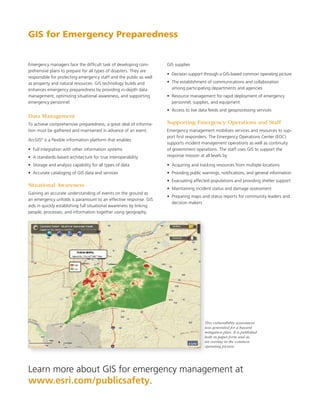
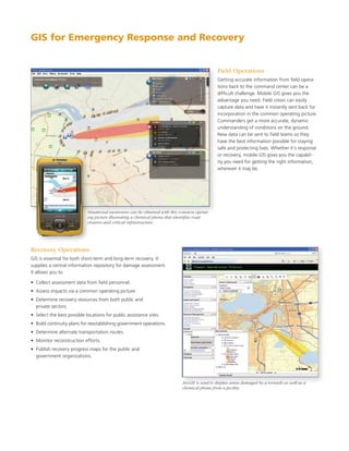
SlideShare a Scribd company logo
1 of 6
Download to read offline
Emergency Management
GIS	for	Comprehensive	Emergency	Management
GIS for Emergency Mitigation


You need to know where your
vulnerabilities are before an
emergency	strikes.	A	geographic	
information	system	(GIS)	gives	you	
tools to proactively identify risks
and	take	action.	Powerful	mapping	
and analysis capabilities help you
plan ahead and be prepared.


Planning and Analysis
GIS technology provides the capa-
bility to map and analyze hazards
of all types and visualize their
potential impacts. When natural or
man-made hazards are fused with
critical infrastructure, population
densities, and other community
values, vulnerabilities can be better The NOAA weather warnings and watches let the EOC know if there are any forecasts of severe weather that could
understood.                           impact the jurisdiction.

When	hazards	have	been	identified	and	mapped,	their	severity	
and proximity to community values drive mitigation strategies. You
can begin to prioritize plans using GIS-based intelligence.


                                                                                                                   GIS can help identify community
                                                                                                                   values at risk to drive mitigation
                                                                                                                   priorities.


Hydrogen sulfide plume modeling and area of dispersion using ArcGIS.
GIS for Emergency Management


Terrorist attacks; devastating natural disasters; budgetary con-             GIS technology gives you the capability you need to overcome chal-
straints; and a greater mandate for collaboration among local,               lenges and meet mission requirements. It provides powerful yet
state, and federal agencies are just a few of the challenges you             easy-to-use tools for the four phases of emergency management:
face today.
                                                                             •	 Mitigation
Emergency management organizations are responsible for                       •	 Preparedness
reducing vulnerabilities and establishing an effective response.
                                                                             •	 Response
Identifying hazards, analyzing community values at risk, develop-
ing mitigation and response plans, maintaining situational aware-            •	 Recovery
ness, managing resources, and supporting response and recovery               GIS enables emergency management professionals to collect vast
are complex responsibilities.                                                amounts of data that can be quickly transformed into actionable
                                                                             information. You can reduce response times, gain comprehensive
                                                                             situational awareness, and improve communication.


                                       GIS Applies the Geographic Approach


                                                                                            Integrate
                                                                                           and Analyze


            Many Data Sources


                                          Coordinated
                                            Action                                                                       Turn into Actionable
                                                                                                                             Intelligence


                              Creating the
                            Common Operating
                                Picture


                                       Share            Communicate           Collaborate


GIS provides the capability to meet every aspect of the emergency management decision support cycle—from acquiring, analyzing, and managing
disparate data to supplying coordinated action. This results in better decisions, greater efficiency, and more effective communications.
GIS for Emergency Preparedness


Emergency	managers	face	the	difficult	task	of	developing	com-        GIS supplies
prehensive plans to prepare for all types of disasters. They are
                                                                     •	 Decision	support	through	a	GIS-based	common	operating	picture	
responsible for protecting emergency staff and the public as well
as property and natural resources. GIS technology builds and         •	 The	establishment	of	communications	and	collaboration	
enhances emergency preparedness by providing in-depth data              among participating departments and agencies
management, optimizing situational awareness, and supporting         •	 Resource	management	for	rapid	deployment	of	emergency	
emergency personnel.                                                    personnel, supplies, and equipment
                                                                     •	 Access	to	live	data	feeds	and	geoprocessing	services	
Data Management
To achieve comprehensive preparedness, a great deal of informa-      Supporting Emergency Operations and Staff
tion must be gathered and maintained in advance of an event.         Emergency management mobilizes services and resources to sup-
                                                                     port	first	responders.	The	Emergency	Operations	Center	(EOC)	
ArcGIS is a flexible information platform that enables
       ®

                                                                     supports incident management operations as well as continuity
•	 Full	integration	with	other	information	systems	                  of government operations. The staff uses GIS to support the
•	 A	standards-based	architecture	for	true	interoperability	         response mission at all levels by

•	 Storage	and	analysis	capability	for	all	types	of	data             •	 Acquiring	and	tracking	resources	from	multiple	locations	
•	 Accurate	cataloging	of	GIS	data	and	services	                     •	 Providing	public	warnings,	notifications,	and	general	information	
                                                                     •	 Evacuating	affected	populations	and	providing	shelter	support	
                                                                                                                                     	
Situational Awareness
                                                                     •	 Maintaining	incident	status	and	damage	assessment	
Gaining an accurate understanding of events on the ground as
                                                                     •		Preparing	maps	and	status	reports	for	community	leaders	and	
an emergency unfolds is paramount to an effective response. GIS
                                                                        decision makers
aids in quickly establishing full situational awareness by linking
people, processes, and information together using geography.


                                                                                         This vulnerability assessment
                                                                                         was generated for a hazard
                                                                                         mitigation plan. It is published
                                                                                         both in paper form and as
                                                                                         an overlay in the common
                                                                                         operating picture.


Learn more about GIS for emergency management at
www.esri.com/publicsafety.
GIS for Emergency Response and Recovery


                                                                                              Field Operations
                                                                                              Getting	accurate	information	from	field	opera-
                                                                                              tions back to the command center can be a
                                                                                              difficult	challenge.	Mobile	GIS	gives	you	the	
                                                                                              advantage you need. Field crews can easily
                                                                                              capture data and have it instantly sent back for
                                                                                              incorporation in the common operating picture.
                                                                                              Commanders get a more accurate, dynamic
                                                                                              understanding of conditions on the ground.
                                                                                              New	data	can	be	sent	to	field	teams	so	they	
                                                                                              have the best information possible for staying
                                                                                              safe and protecting lives. Whether it’s response
                                                                                              or recovery, mobile GIS gives you the capabil-
                                                                                              ity you need for getting the right information,
                                                                                              wherever it may be.


                            Situational awareness can be obtained with this common operat-
                            ing picture illustrating a chemical plume that identifies road
                            closures and critical infrastructure.


Recovery Operations
GIS is essential for both short-term and long-term recovery. It
supplies a central information repository for damage assessment.
It allows you to

•	 Collect	assessment	data	from	field	personnel.
•	 Assess	impacts	via	a	common	operating	picture.
•	 Determine	recovery	resources	from	both	public	and	
   private sectors.
•	 Select	the	best	possible	locations	for	public	assistance	sites.
•	 Build	continuity	plans	for	reestablishing	government	operations.
•	 Determine	alternate	transportation	routes.
•	 Monitor	reconstruction	efforts.
•	 Publish	recovery	progress	maps	for	the	public	and	
   government organizations.


                                                                            ArcGIS is used to display areas damaged by a tornado as well as a
                                                                            chemical plume from a facility.
About ESRI                                                                                      Our Focus                                                                                Contact ESRI

For	four	decades,	ESRI	has	been	                                                                At	ESRI,	we	focus	on	promoting	                                                          1-800-GIS-XPRT	(1-800-447-9778)
helping people make better                                                                      the value of GIS and its applications                                                    Phone:	909-793-2853
decisions through management and                                                                throughout the world and pay close                                                       Fax:	909-793-5953
analysis of geographic information.                                                             attention	to	our	users’	needs.	Our	                                                      info@esri.com
Our	culturally	diverse	staff	work	                                                              software development and services                                                        www.esri.com
with our business partners and                                                                  respond to our customers with
                                                                                                                                                                                         Offices	worldwide
hundreds of thousands of people                                                                 products that are easy to use, flexible,
                                                                                                                                                                                         www.esri.com/locations
who use GIS to make a difference                                                                and	integrated.	Our	technology	is	
in our world.                                                                                   multidisciplinary, productive, and
                                                                                                valuable to our users.
A	full-service	GIS	company,	ESRI	
offers support for implementing                                                                 We have a strong commitment to
GIS technology from the desktop                                                                 educating our customers through
to enterprise-wide servers, online                                                              ESRI’s	various	training	programs.	ESRI	
services, and mobile devices.                                                                   is a socially conscious business and
GIS solutions are flexible and                                                                  invests heavily in issues regarding
customizable to meet the needs of                                                               education, conservation, sustainable
all our users.                                                                                  development, and humanitarian affairs.


                                ESRI
                                380 New York Street
                                Redlands,	California
                                92373-8100	USA	


Copyright	©	2009	ESRI.	All	rights	reserved.	ESRI,	the	ESRI	globe	logo,	ArcGIS,	The	Geographic	Approach,	@esri.com,	and	www.esri.com	are	trademarks,	registered	trademarks,	or	service	
marks	of	ESRI	in	the	United	States,	the	European	Community,	or	certain	other	jurisdictions.	Other	companies	and	products	mentioned	herein	may	be	trademarks	or	registered	trademarks	
of their respective trademark owners.

116432
12.5M6/09sp                                                                                                                                                                                                                Printed	in	USA

More Related Content

Similar to GIS for Comprehensive Emergency Management

Public Safety Enterprise: GIS Solutions for Community Protection and Response
Public Safety Enterprise: GIS Solutions for Community Protection and ResponsePublic Safety Enterprise: GIS Solutions for Community Protection and Response
Public Safety Enterprise: GIS Solutions for Community Protection and ResponseEsri
 
A Quick Guide to Building a GIS for Your Public Safety Agency
A Quick Guide to Building a GIS for Your Public Safety AgencyA Quick Guide to Building a GIS for Your Public Safety Agency
A Quick Guide to Building a GIS for Your Public Safety AgencyEsri
 
Emergency response management using gis
Emergency response management using gisEmergency response management using gis
Emergency response management using gisEsri India
 
Gis in disaster managemant
Gis  in disaster managemantGis  in disaster managemant
Gis in disaster managemantnisarg gandhi
 
Gis in disaster managemant
Gis  in disaster managemantGis  in disaster managemant
Gis in disaster managemantnisarg gandhi
 
Esri Technology for Homeland Security
Esri Technology for Homeland SecurityEsri Technology for Homeland Security
Esri Technology for Homeland SecurityEsri
 
Iirs lecture space inputs to disaster management in india
Iirs lecture space inputs to disaster management in indiaIirs lecture space inputs to disaster management in india
Iirs lecture space inputs to disaster management in indiaTushar Dholakia
 
Digital cartography and natural disaster management
Digital cartography and natural disaster managementDigital cartography and natural disaster management
Digital cartography and natural disaster managementGCUF
 
Application of gis in natural disaster management
Application of gis in natural disaster managementApplication of gis in natural disaster management
Application of gis in natural disaster managementMuhammad Sajjad
 
GIS in National Security
GIS in National SecurityGIS in National Security
GIS in National SecurityEsri
 
Using GIS Technology to Improve Emergency Management
Using GIS Technology to Improve Emergency ManagementUsing GIS Technology to Improve Emergency Management
Using GIS Technology to Improve Emergency ManagementAmberStacy
 
GIS Best Practices for Insurance
GIS Best Practices for InsuranceGIS Best Practices for Insurance
GIS Best Practices for InsuranceEsri
 
GIS for geophysics.pptx
GIS for geophysics.pptxGIS for geophysics.pptx
GIS for geophysics.pptxThomasHundasa1
 
Some of Dr. Nishant Sinha's Research Papers
Some of Dr. Nishant Sinha's Research PapersSome of Dr. Nishant Sinha's Research Papers
Some of Dr. Nishant Sinha's Research PapersNishant Sinha
 
Introduction to GIS.ppt
Introduction to GIS.pptIntroduction to GIS.ppt
Introduction to GIS.pptHDaas1
 
GIS for risk assesment.pptx
GIS for risk assesment.pptxGIS for risk assesment.pptx
GIS for risk assesment.pptxZahidAyoub4
 

Similar to GIS for Comprehensive Emergency Management (20)

Public Safety Enterprise: GIS Solutions for Community Protection and Response
Public Safety Enterprise: GIS Solutions for Community Protection and ResponsePublic Safety Enterprise: GIS Solutions for Community Protection and Response
Public Safety Enterprise: GIS Solutions for Community Protection and Response
 
A Quick Guide to Building a GIS for Your Public Safety Agency
A Quick Guide to Building a GIS for Your Public Safety AgencyA Quick Guide to Building a GIS for Your Public Safety Agency
A Quick Guide to Building a GIS for Your Public Safety Agency
 
Emergency response management using gis
Emergency response management using gisEmergency response management using gis
Emergency response management using gis
 
GIS For Wildfire
GIS For WildfireGIS For Wildfire
GIS For Wildfire
 
Gis in disaster managemant
Gis  in disaster managemantGis  in disaster managemant
Gis in disaster managemant
 
Gis in disaster managemant
Gis  in disaster managemantGis  in disaster managemant
Gis in disaster managemant
 
Esri Technology for Homeland Security
Esri Technology for Homeland SecurityEsri Technology for Homeland Security
Esri Technology for Homeland Security
 
Iirs lecture space inputs to disaster management in india
Iirs lecture space inputs to disaster management in indiaIirs lecture space inputs to disaster management in india
Iirs lecture space inputs to disaster management in india
 
Process of hazard mapping
Process of hazard mappingProcess of hazard mapping
Process of hazard mapping
 
Digital cartography and natural disaster management
Digital cartography and natural disaster managementDigital cartography and natural disaster management
Digital cartography and natural disaster management
 
Application of gis in natural disaster management
Application of gis in natural disaster managementApplication of gis in natural disaster management
Application of gis in natural disaster management
 
GIS in National Security
GIS in National SecurityGIS in National Security
GIS in National Security
 
Using GIS Technology to Improve Emergency Management
Using GIS Technology to Improve Emergency ManagementUsing GIS Technology to Improve Emergency Management
Using GIS Technology to Improve Emergency Management
 
GIS Best Practices for Insurance
GIS Best Practices for InsuranceGIS Best Practices for Insurance
GIS Best Practices for Insurance
 
GIS for geophysics.pptx
GIS for geophysics.pptxGIS for geophysics.pptx
GIS for geophysics.pptx
 
The Internet and Rural Development
The Internet and Rural DevelopmentThe Internet and Rural Development
The Internet and Rural Development
 
Em mag jan10
Em mag jan10Em mag jan10
Em mag jan10
 
Some of Dr. Nishant Sinha's Research Papers
Some of Dr. Nishant Sinha's Research PapersSome of Dr. Nishant Sinha's Research Papers
Some of Dr. Nishant Sinha's Research Papers
 
Introduction to GIS.ppt
Introduction to GIS.pptIntroduction to GIS.ppt
Introduction to GIS.ppt
 
GIS for risk assesment.pptx
GIS for risk assesment.pptxGIS for risk assesment.pptx
GIS for risk assesment.pptx
 

More from Esri

INIA- CISA: Análisis de las amenazas en la fauna silvestre
INIA- CISA: Análisis de las amenazas en la fauna silvestreINIA- CISA: Análisis de las amenazas en la fauna silvestre
INIA- CISA: Análisis de las amenazas en la fauna silvestreEsri
 
Aena Aeropuerto Adolfo Suárez-Barajas crea potentes aplicaciones para sus cli...
Aena Aeropuerto Adolfo Suárez-Barajas crea potentes aplicaciones para sus cli...Aena Aeropuerto Adolfo Suárez-Barajas crea potentes aplicaciones para sus cli...
Aena Aeropuerto Adolfo Suárez-Barajas crea potentes aplicaciones para sus cli...Esri
 
Plataforma Smart City de Móstoles
Plataforma Smart City de MóstolesPlataforma Smart City de Móstoles
Plataforma Smart City de MóstolesEsri
 
ArcGIS Online para Organizaciones
ArcGIS Online para OrganizacionesArcGIS Online para Organizaciones
ArcGIS Online para OrganizacionesEsri
 
Molina de Segura se convierte en una smart city
Molina de Segura se convierte en una smart cityMolina de Segura se convierte en una smart city
Molina de Segura se convierte en una smart cityEsri
 
Portal for ArcGIS
Portal for ArcGISPortal for ArcGIS
Portal for ArcGISEsri
 
GIS-Based Web Services Provide Rapid Analysis and Dissemination of Maritime Data
GIS-Based Web Services Provide Rapid Analysis and Dissemination of Maritime DataGIS-Based Web Services Provide Rapid Analysis and Dissemination of Maritime Data
GIS-Based Web Services Provide Rapid Analysis and Dissemination of Maritime DataEsri
 
An Effective Tool for Drinking Water Protection
An Effective Tool for Drinking Water ProtectionAn Effective Tool for Drinking Water Protection
An Effective Tool for Drinking Water ProtectionEsri
 
GeoCollector for ArcPad
GeoCollector for ArcPadGeoCollector for ArcPad
GeoCollector for ArcPadEsri
 
GeoCollector for ArcGIS for Windows Mobile
GeoCollector for ArcGIS for Windows MobileGeoCollector for ArcGIS for Windows Mobile
GeoCollector for ArcGIS for Windows MobileEsri
 
Data Appliance for ArcGIS
Data Appliance for ArcGISData Appliance for ArcGIS
Data Appliance for ArcGISEsri
 
Esri and BlackBridge
Esri and BlackBridgeEsri and BlackBridge
Esri and BlackBridgeEsri
 
GeoPlanner for ArcGIS
GeoPlanner for ArcGISGeoPlanner for ArcGIS
GeoPlanner for ArcGISEsri
 
Esri and AccuWeather
Esri and AccuWeatherEsri and AccuWeather
Esri and AccuWeatherEsri
 
Esri and Airbus Defense & Space
Esri and Airbus Defense & SpaceEsri and Airbus Defense & Space
Esri and Airbus Defense & SpaceEsri
 
Esri US Data Fact Sheet
Esri US Data Fact SheetEsri US Data Fact Sheet
Esri US Data Fact SheetEsri
 
ArcGIS for Server on Microsoft Azure Jumpstart
ArcGIS for Server on Microsoft Azure JumpstartArcGIS for Server on Microsoft Azure Jumpstart
ArcGIS for Server on Microsoft Azure JumpstartEsri
 
ArcGIS for the Military--Maritime Operations
ArcGIS for the Military--Maritime OperationsArcGIS for the Military--Maritime Operations
ArcGIS for the Military--Maritime OperationsEsri
 
Esri Geoportal Server
Esri Geoportal ServerEsri Geoportal Server
Esri Geoportal ServerEsri
 
ArcGIS GeoEvent Extension for Server
ArcGIS GeoEvent Extension for ServerArcGIS GeoEvent Extension for Server
ArcGIS GeoEvent Extension for ServerEsri
 

More from Esri (20)

INIA- CISA: Análisis de las amenazas en la fauna silvestre
INIA- CISA: Análisis de las amenazas en la fauna silvestreINIA- CISA: Análisis de las amenazas en la fauna silvestre
INIA- CISA: Análisis de las amenazas en la fauna silvestre
 
Aena Aeropuerto Adolfo Suárez-Barajas crea potentes aplicaciones para sus cli...
Aena Aeropuerto Adolfo Suárez-Barajas crea potentes aplicaciones para sus cli...Aena Aeropuerto Adolfo Suárez-Barajas crea potentes aplicaciones para sus cli...
Aena Aeropuerto Adolfo Suárez-Barajas crea potentes aplicaciones para sus cli...
 
Plataforma Smart City de Móstoles
Plataforma Smart City de MóstolesPlataforma Smart City de Móstoles
Plataforma Smart City de Móstoles
 
ArcGIS Online para Organizaciones
ArcGIS Online para OrganizacionesArcGIS Online para Organizaciones
ArcGIS Online para Organizaciones
 
Molina de Segura se convierte en una smart city
Molina de Segura se convierte en una smart cityMolina de Segura se convierte en una smart city
Molina de Segura se convierte en una smart city
 
Portal for ArcGIS
Portal for ArcGISPortal for ArcGIS
Portal for ArcGIS
 
GIS-Based Web Services Provide Rapid Analysis and Dissemination of Maritime Data
GIS-Based Web Services Provide Rapid Analysis and Dissemination of Maritime DataGIS-Based Web Services Provide Rapid Analysis and Dissemination of Maritime Data
GIS-Based Web Services Provide Rapid Analysis and Dissemination of Maritime Data
 
An Effective Tool for Drinking Water Protection
An Effective Tool for Drinking Water ProtectionAn Effective Tool for Drinking Water Protection
An Effective Tool for Drinking Water Protection
 
GeoCollector for ArcPad
GeoCollector for ArcPadGeoCollector for ArcPad
GeoCollector for ArcPad
 
GeoCollector for ArcGIS for Windows Mobile
GeoCollector for ArcGIS for Windows MobileGeoCollector for ArcGIS for Windows Mobile
GeoCollector for ArcGIS for Windows Mobile
 
Data Appliance for ArcGIS
Data Appliance for ArcGISData Appliance for ArcGIS
Data Appliance for ArcGIS
 
Esri and BlackBridge
Esri and BlackBridgeEsri and BlackBridge
Esri and BlackBridge
 
GeoPlanner for ArcGIS
GeoPlanner for ArcGISGeoPlanner for ArcGIS
GeoPlanner for ArcGIS
 
Esri and AccuWeather
Esri and AccuWeatherEsri and AccuWeather
Esri and AccuWeather
 
Esri and Airbus Defense & Space
Esri and Airbus Defense & SpaceEsri and Airbus Defense & Space
Esri and Airbus Defense & Space
 
Esri US Data Fact Sheet
Esri US Data Fact SheetEsri US Data Fact Sheet
Esri US Data Fact Sheet
 
ArcGIS for Server on Microsoft Azure Jumpstart
ArcGIS for Server on Microsoft Azure JumpstartArcGIS for Server on Microsoft Azure Jumpstart
ArcGIS for Server on Microsoft Azure Jumpstart
 
ArcGIS for the Military--Maritime Operations
ArcGIS for the Military--Maritime OperationsArcGIS for the Military--Maritime Operations
ArcGIS for the Military--Maritime Operations
 
Esri Geoportal Server
Esri Geoportal ServerEsri Geoportal Server
Esri Geoportal Server
 
ArcGIS GeoEvent Extension for Server
ArcGIS GeoEvent Extension for ServerArcGIS GeoEvent Extension for Server
ArcGIS GeoEvent Extension for Server
 

Recently uploaded

Install Stable Diffusion in windows machine
Install Stable Diffusion in windows machineInstall Stable Diffusion in windows machine
Install Stable Diffusion in windows machinePadma Pradeep
 
The Codex of Business Writing Software for Real-World Solutions 2.pptx
The Codex of Business Writing Software for Real-World Solutions 2.pptxThe Codex of Business Writing Software for Real-World Solutions 2.pptx
The Codex of Business Writing Software for Real-World Solutions 2.pptxMalak Abu Hammad
 
Pigging Solutions in Pet Food Manufacturing
Pigging Solutions in Pet Food ManufacturingPigging Solutions in Pet Food Manufacturing
Pigging Solutions in Pet Food ManufacturingPigging Solutions
 
Swan(sea) Song – personal research during my six years at Swansea ... and bey...
Swan(sea) Song – personal research during my six years at Swansea ... and bey...Swan(sea) Song – personal research during my six years at Swansea ... and bey...
Swan(sea) Song – personal research during my six years at Swansea ... and bey...Alan Dix
 
#StandardsGoals for 2024: What’s new for BISAC - Tech Forum 2024
#StandardsGoals for 2024: What’s new for BISAC - Tech Forum 2024#StandardsGoals for 2024: What’s new for BISAC - Tech Forum 2024
#StandardsGoals for 2024: What’s new for BISAC - Tech Forum 2024BookNet Canada
 
Tech-Forward - Achieving Business Readiness For Copilot in Microsoft 365
Tech-Forward - Achieving Business Readiness For Copilot in Microsoft 365Tech-Forward - Achieving Business Readiness For Copilot in Microsoft 365
Tech-Forward - Achieving Business Readiness For Copilot in Microsoft 3652toLead Limited
 
Pigging Solutions Piggable Sweeping Elbows
Pigging Solutions Piggable Sweeping ElbowsPigging Solutions Piggable Sweeping Elbows
Pigging Solutions Piggable Sweeping ElbowsPigging Solutions
 
Next-generation AAM aircraft unveiled by Supernal, S-A2
Next-generation AAM aircraft unveiled by Supernal, S-A2Next-generation AAM aircraft unveiled by Supernal, S-A2
Next-generation AAM aircraft unveiled by Supernal, S-A2Hyundai Motor Group
 
SQL Database Design For Developers at php[tek] 2024
SQL Database Design For Developers at php[tek] 2024SQL Database Design For Developers at php[tek] 2024
SQL Database Design For Developers at php[tek] 2024Scott Keck-Warren
 
Maximizing Board Effectiveness 2024 Webinar.pptx
Maximizing Board Effectiveness 2024 Webinar.pptxMaximizing Board Effectiveness 2024 Webinar.pptx
Maximizing Board Effectiveness 2024 Webinar.pptxOnBoard
 
GenCyber Cyber Security Day Presentation
GenCyber Cyber Security Day PresentationGenCyber Cyber Security Day Presentation
GenCyber Cyber Security Day PresentationMichael W. Hawkins
 
Kotlin Multiplatform & Compose Multiplatform - Starter kit for pragmatics
Kotlin Multiplatform & Compose Multiplatform - Starter kit for pragmaticsKotlin Multiplatform & Compose Multiplatform - Starter kit for pragmatics
Kotlin Multiplatform & Compose Multiplatform - Starter kit for pragmaticscarlostorres15106
 
Advanced Test Driven-Development @ php[tek] 2024
Advanced Test Driven-Development @ php[tek] 2024Advanced Test Driven-Development @ php[tek] 2024
Advanced Test Driven-Development @ php[tek] 2024Scott Keck-Warren
 
Transcript: #StandardsGoals for 2024: What’s new for BISAC - Tech Forum 2024
Transcript: #StandardsGoals for 2024: What’s new for BISAC - Tech Forum 2024Transcript: #StandardsGoals for 2024: What’s new for BISAC - Tech Forum 2024
Transcript: #StandardsGoals for 2024: What’s new for BISAC - Tech Forum 2024BookNet Canada
 
Enhancing Worker Digital Experience: A Hands-on Workshop for Partners
Enhancing Worker Digital Experience: A Hands-on Workshop for PartnersEnhancing Worker Digital Experience: A Hands-on Workshop for Partners
Enhancing Worker Digital Experience: A Hands-on Workshop for PartnersThousandEyes
 
IAC 2024 - IA Fast Track to Search Focused AI Solutions
IAC 2024 - IA Fast Track to Search Focused AI SolutionsIAC 2024 - IA Fast Track to Search Focused AI Solutions
IAC 2024 - IA Fast Track to Search Focused AI SolutionsEnterprise Knowledge
 
Injustice - Developers Among Us (SciFiDevCon 2024)
Injustice - Developers Among Us (SciFiDevCon 2024)Injustice - Developers Among Us (SciFiDevCon 2024)
Injustice - Developers Among Us (SciFiDevCon 2024)Allon Mureinik
 
How to Remove Document Management Hurdles with X-Docs?
How to Remove Document Management Hurdles with X-Docs?How to Remove Document Management Hurdles with X-Docs?
How to Remove Document Management Hurdles with X-Docs?XfilesPro
 
Key Features Of Token Development (1).pptx
Key  Features Of Token  Development (1).pptxKey  Features Of Token  Development (1).pptx
Key Features Of Token Development (1).pptxLBM Solutions
 

Recently uploaded (20)

Install Stable Diffusion in windows machine
Install Stable Diffusion in windows machineInstall Stable Diffusion in windows machine
Install Stable Diffusion in windows machine
 
The Codex of Business Writing Software for Real-World Solutions 2.pptx
The Codex of Business Writing Software for Real-World Solutions 2.pptxThe Codex of Business Writing Software for Real-World Solutions 2.pptx
The Codex of Business Writing Software for Real-World Solutions 2.pptx
 
Pigging Solutions in Pet Food Manufacturing
Pigging Solutions in Pet Food ManufacturingPigging Solutions in Pet Food Manufacturing
Pigging Solutions in Pet Food Manufacturing
 
Swan(sea) Song – personal research during my six years at Swansea ... and bey...
Swan(sea) Song – personal research during my six years at Swansea ... and bey...Swan(sea) Song – personal research during my six years at Swansea ... and bey...
Swan(sea) Song – personal research during my six years at Swansea ... and bey...
 
#StandardsGoals for 2024: What’s new for BISAC - Tech Forum 2024
#StandardsGoals for 2024: What’s new for BISAC - Tech Forum 2024#StandardsGoals for 2024: What’s new for BISAC - Tech Forum 2024
#StandardsGoals for 2024: What’s new for BISAC - Tech Forum 2024
 
Tech-Forward - Achieving Business Readiness For Copilot in Microsoft 365
Tech-Forward - Achieving Business Readiness For Copilot in Microsoft 365Tech-Forward - Achieving Business Readiness For Copilot in Microsoft 365
Tech-Forward - Achieving Business Readiness For Copilot in Microsoft 365
 
Pigging Solutions Piggable Sweeping Elbows
Pigging Solutions Piggable Sweeping ElbowsPigging Solutions Piggable Sweeping Elbows
Pigging Solutions Piggable Sweeping Elbows
 
Next-generation AAM aircraft unveiled by Supernal, S-A2
Next-generation AAM aircraft unveiled by Supernal, S-A2Next-generation AAM aircraft unveiled by Supernal, S-A2
Next-generation AAM aircraft unveiled by Supernal, S-A2
 
SQL Database Design For Developers at php[tek] 2024
SQL Database Design For Developers at php[tek] 2024SQL Database Design For Developers at php[tek] 2024
SQL Database Design For Developers at php[tek] 2024
 
Maximizing Board Effectiveness 2024 Webinar.pptx
Maximizing Board Effectiveness 2024 Webinar.pptxMaximizing Board Effectiveness 2024 Webinar.pptx
Maximizing Board Effectiveness 2024 Webinar.pptx
 
GenCyber Cyber Security Day Presentation
GenCyber Cyber Security Day PresentationGenCyber Cyber Security Day Presentation
GenCyber Cyber Security Day Presentation
 
Vulnerability_Management_GRC_by Sohang Sengupta.pptx
Vulnerability_Management_GRC_by Sohang Sengupta.pptxVulnerability_Management_GRC_by Sohang Sengupta.pptx
Vulnerability_Management_GRC_by Sohang Sengupta.pptx
 
Kotlin Multiplatform & Compose Multiplatform - Starter kit for pragmatics
Kotlin Multiplatform & Compose Multiplatform - Starter kit for pragmaticsKotlin Multiplatform & Compose Multiplatform - Starter kit for pragmatics
Kotlin Multiplatform & Compose Multiplatform - Starter kit for pragmatics
 
Advanced Test Driven-Development @ php[tek] 2024
Advanced Test Driven-Development @ php[tek] 2024Advanced Test Driven-Development @ php[tek] 2024
Advanced Test Driven-Development @ php[tek] 2024
 
Transcript: #StandardsGoals for 2024: What’s new for BISAC - Tech Forum 2024
Transcript: #StandardsGoals for 2024: What’s new for BISAC - Tech Forum 2024Transcript: #StandardsGoals for 2024: What’s new for BISAC - Tech Forum 2024
Transcript: #StandardsGoals for 2024: What’s new for BISAC - Tech Forum 2024
 
Enhancing Worker Digital Experience: A Hands-on Workshop for Partners
Enhancing Worker Digital Experience: A Hands-on Workshop for PartnersEnhancing Worker Digital Experience: A Hands-on Workshop for Partners
Enhancing Worker Digital Experience: A Hands-on Workshop for Partners
 
IAC 2024 - IA Fast Track to Search Focused AI Solutions
IAC 2024 - IA Fast Track to Search Focused AI SolutionsIAC 2024 - IA Fast Track to Search Focused AI Solutions
IAC 2024 - IA Fast Track to Search Focused AI Solutions
 
Injustice - Developers Among Us (SciFiDevCon 2024)
Injustice - Developers Among Us (SciFiDevCon 2024)Injustice - Developers Among Us (SciFiDevCon 2024)
Injustice - Developers Among Us (SciFiDevCon 2024)
 
How to Remove Document Management Hurdles with X-Docs?
How to Remove Document Management Hurdles with X-Docs?How to Remove Document Management Hurdles with X-Docs?
How to Remove Document Management Hurdles with X-Docs?
 
Key Features Of Token Development (1).pptx
Key  Features Of Token  Development (1).pptxKey  Features Of Token  Development (1).pptx
Key Features Of Token Development (1).pptx
 

GIS for Comprehensive Emergency Management

  • 2. GIS for Emergency Mitigation You need to know where your vulnerabilities are before an emergency strikes. A geographic information system (GIS) gives you tools to proactively identify risks and take action. Powerful mapping and analysis capabilities help you plan ahead and be prepared. Planning and Analysis GIS technology provides the capa- bility to map and analyze hazards of all types and visualize their potential impacts. When natural or man-made hazards are fused with critical infrastructure, population densities, and other community values, vulnerabilities can be better The NOAA weather warnings and watches let the EOC know if there are any forecasts of severe weather that could understood. impact the jurisdiction. When hazards have been identified and mapped, their severity and proximity to community values drive mitigation strategies. You can begin to prioritize plans using GIS-based intelligence. GIS can help identify community values at risk to drive mitigation priorities. Hydrogen sulfide plume modeling and area of dispersion using ArcGIS.
  • 3. GIS for Emergency Management Terrorist attacks; devastating natural disasters; budgetary con- GIS technology gives you the capability you need to overcome chal- straints; and a greater mandate for collaboration among local, lenges and meet mission requirements. It provides powerful yet state, and federal agencies are just a few of the challenges you easy-to-use tools for the four phases of emergency management: face today. • Mitigation Emergency management organizations are responsible for • Preparedness reducing vulnerabilities and establishing an effective response. • Response Identifying hazards, analyzing community values at risk, develop- ing mitigation and response plans, maintaining situational aware- • Recovery ness, managing resources, and supporting response and recovery GIS enables emergency management professionals to collect vast are complex responsibilities. amounts of data that can be quickly transformed into actionable information. You can reduce response times, gain comprehensive situational awareness, and improve communication. GIS Applies the Geographic Approach Integrate and Analyze Many Data Sources Coordinated Action Turn into Actionable Intelligence Creating the Common Operating Picture Share Communicate Collaborate GIS provides the capability to meet every aspect of the emergency management decision support cycle—from acquiring, analyzing, and managing disparate data to supplying coordinated action. This results in better decisions, greater efficiency, and more effective communications.
  • 4. GIS for Emergency Preparedness Emergency managers face the difficult task of developing com- GIS supplies prehensive plans to prepare for all types of disasters. They are • Decision support through a GIS-based common operating picture responsible for protecting emergency staff and the public as well as property and natural resources. GIS technology builds and • The establishment of communications and collaboration enhances emergency preparedness by providing in-depth data among participating departments and agencies management, optimizing situational awareness, and supporting • Resource management for rapid deployment of emergency emergency personnel. personnel, supplies, and equipment • Access to live data feeds and geoprocessing services Data Management To achieve comprehensive preparedness, a great deal of informa- Supporting Emergency Operations and Staff tion must be gathered and maintained in advance of an event. Emergency management mobilizes services and resources to sup- port first responders. The Emergency Operations Center (EOC) ArcGIS is a flexible information platform that enables ® supports incident management operations as well as continuity • Full integration with other information systems of government operations. The staff uses GIS to support the • A standards-based architecture for true interoperability response mission at all levels by • Storage and analysis capability for all types of data • Acquiring and tracking resources from multiple locations • Accurate cataloging of GIS data and services • Providing public warnings, notifications, and general information • Evacuating affected populations and providing shelter support Situational Awareness • Maintaining incident status and damage assessment Gaining an accurate understanding of events on the ground as • Preparing maps and status reports for community leaders and an emergency unfolds is paramount to an effective response. GIS decision makers aids in quickly establishing full situational awareness by linking people, processes, and information together using geography. This vulnerability assessment was generated for a hazard mitigation plan. It is published both in paper form and as an overlay in the common operating picture. Learn more about GIS for emergency management at www.esri.com/publicsafety.
  • 5. GIS for Emergency Response and Recovery Field Operations Getting accurate information from field opera- tions back to the command center can be a difficult challenge. Mobile GIS gives you the advantage you need. Field crews can easily capture data and have it instantly sent back for incorporation in the common operating picture. Commanders get a more accurate, dynamic understanding of conditions on the ground. New data can be sent to field teams so they have the best information possible for staying safe and protecting lives. Whether it’s response or recovery, mobile GIS gives you the capabil- ity you need for getting the right information, wherever it may be. Situational awareness can be obtained with this common operat- ing picture illustrating a chemical plume that identifies road closures and critical infrastructure. Recovery Operations GIS is essential for both short-term and long-term recovery. It supplies a central information repository for damage assessment. It allows you to • Collect assessment data from field personnel. • Assess impacts via a common operating picture. • Determine recovery resources from both public and private sectors. • Select the best possible locations for public assistance sites. • Build continuity plans for reestablishing government operations. • Determine alternate transportation routes. • Monitor reconstruction efforts. • Publish recovery progress maps for the public and government organizations. ArcGIS is used to display areas damaged by a tornado as well as a chemical plume from a facility.
  • 6. About ESRI Our Focus Contact ESRI For four decades, ESRI has been At ESRI, we focus on promoting 1-800-GIS-XPRT (1-800-447-9778) helping people make better the value of GIS and its applications Phone: 909-793-2853 decisions through management and throughout the world and pay close Fax: 909-793-5953 analysis of geographic information. attention to our users’ needs. Our info@esri.com Our culturally diverse staff work software development and services www.esri.com with our business partners and respond to our customers with Offices worldwide hundreds of thousands of people products that are easy to use, flexible, www.esri.com/locations who use GIS to make a difference and integrated. Our technology is in our world. multidisciplinary, productive, and valuable to our users. A full-service GIS company, ESRI offers support for implementing We have a strong commitment to GIS technology from the desktop educating our customers through to enterprise-wide servers, online ESRI’s various training programs. ESRI services, and mobile devices. is a socially conscious business and GIS solutions are flexible and invests heavily in issues regarding customizable to meet the needs of education, conservation, sustainable all our users. development, and humanitarian affairs. ESRI 380 New York Street Redlands, California 92373-8100 USA Copyright © 2009 ESRI. All rights reserved. ESRI, the ESRI globe logo, ArcGIS, The Geographic Approach, @esri.com, and www.esri.com are trademarks, registered trademarks, or service marks of ESRI in the United States, the European Community, or certain other jurisdictions. Other companies and products mentioned herein may be trademarks or registered trademarks of their respective trademark owners. 116432 12.5M6/09sp Printed in USA