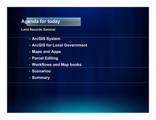
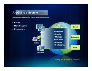
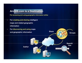
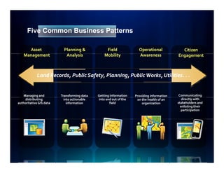
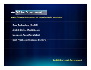
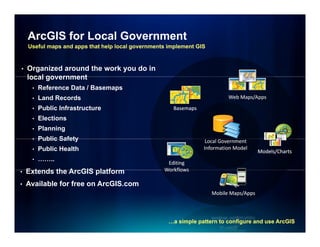
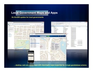
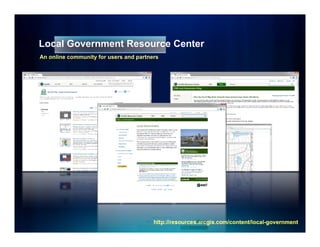
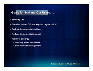
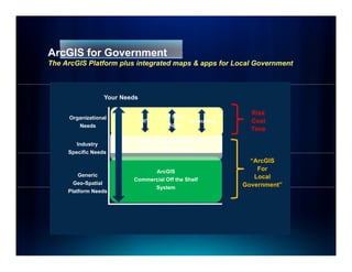
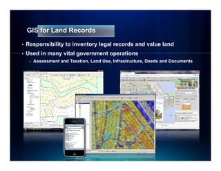
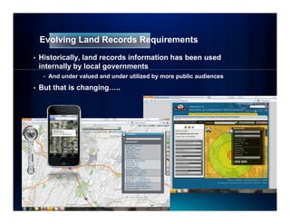
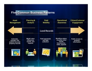
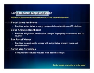
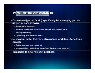
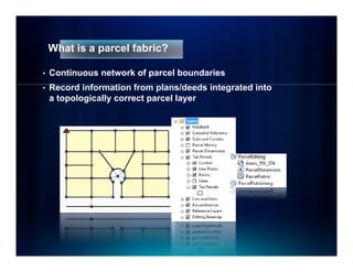
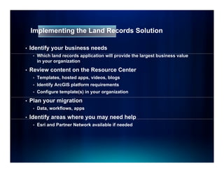
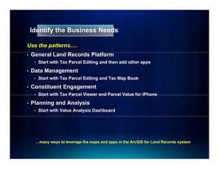
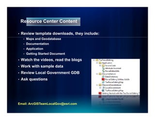
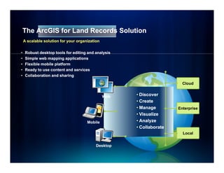
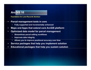
ArcGIS for Land Records

                Seminar Series
                S i     S i
                 Summer 2011
Agenda for today
Land Records Seminar


    •   ArcGIS S t
        A GIS System
    •   ArcGIS for Local Government
    •   Maps and Apps
    •   Parcel Editing
    •   Workflows and Map books
    •   Scenarios
    •   Summary
ArcGIS is a System
A Complete System for Geographic Information


•   E i
    Easier
•   More Powerful
                                                                      Cloud
•   Everywhere
                                  Web          • Di
                                                 Discover
                                               • Create
                                               • Manage             Enterprise
                                               • Visualize
                         Mobile                • Analyze
                                               • Collaborate
                                                                      Local


                             Desktop


                                               Making GIS Available to Everyone
ArcGIS.com is a Destination
    For accessing and using geographic information online


•   For
    F creating and sharing i t lli
          ti     d h i intelligent t
    maps and related geographic
    information
•   For discovering and using maps
    and geographic information                              Share
                                                                       Groups


                                                                    Search/
                                                                     Use
                      Author
Five Common Business Patterns

      Asset                Planning &             Field              Operational             Citizen
    Management
    M                       Analysis
                            A l i                Mobility
                                                 M bili              Awareness
                                                                     A                     Engagement


             Land Records, Public Safety, Planning, Public Works, Utilities. . .
                  Records         Safety Planning          Works Utilities


   Managing and
         g g             Transforming data
                                      g      Getting information
                                                   g               Providing information
                                                                           g                Communicating
    distributing           into actionable   into and out of the    on the health of an       directly with
authoritative GIS data       information             field             organization        stakeholders and
                                                                                             enlisting their
                                                                                             participation
ArcGIS for Government
Making GIS easier to implement and more effective for government


• Core Technology (ArcGIS)

• ArcGIS Online (ArcGIS.com)

• Maps and Apps (Templates)

• B tP
  Best Practices (Resource C t
           ti    (R        Centers)
                                  )


                                                    ArcGIS for Local Government
ArcGIS for Local Government
    Useful maps and apps that help local governments implement GIS


•   Organized around the work you do in
    local government
     •   Reference Data / Basemaps
     •   Land Records                                                      Web Maps/Apps

     •   Public Infrastructure                        Basemaps
     •   Elections
     •   Planning
     •   Public Safety                                            Local Government
     •   Public Health                                           Information Model
                                                                                        Models/Charts
     •   ……..
                                                    Editing
•   Extends the ArcGIS platform                    Workflows

•   Available for free on ArcGIS.com
                                                                     Mobile Maps/Apps


                                                     …a simple pattern to configure and use ArcGIS
Local Government Maps and Apps
An ArcGIS system for local governments


  …desktop, web and mobile apps with meaningful maps supported by a single geodatabase schema
Local Government Resource Center
An online community for users and partners


                                        http://resources.arcgis.com/content/local-
                                        http://resources.arcgis.com/content/local-government
Goals for Esri and Our Users. . .

•   Simplify GIS

•   Broaden use of GIS throughout organization

•   Reduce implementation time

•   Reduce implementation cost

•   Promote synergy
     •   Each app works everywhere
     •   Each map works everywhere


                                        Successful users making a difference
ArcGIS f G
A GIS for Government
                   t
The ArcGIS Platform plus integrated maps & apps for Local Government


                  Your Needs

                                                              Risk
     Organizational                  3rd Party
                                             y
                               DIY             Consulting     Cost
                                                              C t
        Needs                          Apps
                                                              Time
                            Industry data models
        Industry
                           Template Maps & Apps
     Specific Needs
                                                              “ArcGIS
                                ArcGIS                          For
         Generic                                               Local
                          Commercial Off the Shelf
       Geo-Spatial                                          Government”
                                System
     Platform Needs
Demonstration
Local Government Resource Center
GIS for Land Records

•   Responsibility to inventory legal records and value land
•   Used in many vital government operations
     •   Assessment and Taxation, Land Use, Infrastructure, Deeds and Documents
Evolving Land Records Requirements
•   Historically, land records information has been used
    internally by local g
             y y        governments
     •   And under valued and under utilized by more public audiences

•   But that is changing…..
Five Common Business Patterns

  Asset            Planning &         Field          Operational       Citizen/Customer
Management
M                   Analysis
                    A l i            Mobility
                                     M bili          Awareness
                                                     A                   Engagement
                                                                         E


                                 Land Records


   Automate,       Model value   Field appraisals   Workflow status,   Public access to
  manage, andd     influences,
                   influences        and data
                                        dd t         visualize value       property
                                                                                 t
publish accurate   trends, and      collection           trends,         information
property records     Impacts                         foreclosures ,
                                                     sales, appeals
Demonstration
Land Records Maps and Apps
    Helps local governments maximize the value of land records information


•   Parcel Value for iPhone
    •   Provides authoritative property maps and characteristics on iOS platform

•   Value Analysis Dashboard
    •   Provides a high-level view into the changes in property assessments and tax
                   high-
        revenue

•   Tax Parcel Viewer
    •   Provides focused public access with authoritative property maps and
        characteristics

•   Parcel Map Templates
             p    p
    •   Consumer and industry focused multi-scale basemaps
                                      multi-


                                                      Can be hosted on premise or in the cloud
Demonstration
   Parcel Editing
Break – 15 minutes
B   k       i t
Parcel editing with ArcGIS 10

•   Data model (parcel fabric) specifically for managing parcels
    as part of core software
          t f         ft
     -   Topological integrity
     -   Improve positional accuracy of parcels and related data
     -   History T ki
         Hi t    Tracking
     -   Optionally maintain metadata

•   New parcel editor toolbar – streamlines workflows for editing
    parcels
     -   Splits, merges, resurveys, etc
     -   Import digitally submitted data (from CAD or other sources)

•   Templates to give you best practices
What is a parcel fabric?

•   Continuous network of parcel boundaries
•   R
    Record i f
          d information f
                    ti from plans/deeds i t
                               l    /d d integrated i t
                                                t d into
    a topologically correct parcel layer
Why is the parcel fabric important to you?

•   Data model specifically for managing parcels
•   Improved workflows for managing parcels
     -   Based on the operations you do every day – splits, combines, etc.

•   Data integrity and accuracy
             g y              y
•   History tracking (based on both system and legal dates)
•   Optional metadata on plans and editors
Data integrity

•   Land records from plans/deeds are integrated into a
    continuous, topologically correct parcel layer
•   No slivers and gaps
     -   Parcel joining preserves parcel connectivity during incorporation
Data integrity

•   Fabric adjustment uses survey control and COGO
    dimensions to recalculate/update parcel corner points


                                       Improving spatial accuracy over time
Why are accuracy and integrity important?
•   Property tax values derived from legal records (plans/deeds)
•   Accurate and up-to-date land records information used
    throughout government to support many vital functions
•   Other data (including imagery) becoming more accurate
Parcel history enhances integrity

•   Maintained automatically as you edit
     •   System start/end and legal start/end dates supported

•   Not the same as geodatabase archiving
Demonstration
Workflows & Tax Map Books
Editing Workflows

•   Task Assistant allows creation of steps for editors to follow
•   Checkboxes and help information to further guide process
Tax Map Books

•   Standard tools for publishing parcel map book pages
•   Scripting automates map book production
Solutions
S l ti
Implementing the Land Records Solution

•   Identify your business needs
     •   Which land records application will provide the largest business value
         in your organization

•   Review content on the Resource Center
     •   Templates, hosted apps, videos, blogs
     •   Identify ArcGIS platform requirements
     •   Configure template(s) in your organization

•   Plan your migration
     •   Data, workflows, apps

•   Identify areas where y
           y             you may need help
                               y         p
     •   Esri and Partner Network available if needed
Identify the Business Needs

Use the patterns….
•   General Land Records Platform
    G     lL dR       d Pl f
     •   Start with Tax Parcel Editing and then add other apps

•   Data Management
     •   Start with Tax Parcel Editing and Tax Map Book

•   Constituent Engagement
     •   Start with Tax Parcel Viewer and Parcel Value for iPhone

•   Planning and Analysis
     •   Start with Value Analysis Dashboard


     …many ways to leverage the maps and apps in the ArcGIS for Land Records system
Resource Center Content

•   Review template downloads, they include:
     •   Maps and Geodatabase
     •   Documentation
     •   Application
     •   Getting Started Document

•   Watch the videos, read the blogs
•   Work with sample data
     o     t sa p e
•   Review Local Government GDB
•   Ask questions


Email: ArcGISTeamLocalGov@esri.com
Scenarios
 Land Records
Scenario: Implement Tax Parcel Editing Template

•   Review Tax Parcel Editing Template
                            g    p
     •   Editing map – well defined layers, label expressions
         and attractive cartography
     •   Productivity tools – enhance the core editing
            i
         environment t
     •   Geodatabase – methods for managing multiple
         parcel types in a parcel fabric, annotation best
         practices

•   Review how consistent your data is with the
    Local Government Model GDB
Scenario: Implement Tax Parcel Editing Template

•   Download White Paper - Loading Data Into a Parcel Fabric
•   I
    Important aspects:
         t t       t
     •   Different paths depending on state of source data
     •   Using a topology to check initial data integrity
     •   Delineating curves
         D li   ti
     •   Modeling parcel types (lots, subdivisions, etc.)
     •   Annotation
Scenario: Implement Tax Parcel Editing Template

•   Lets start migrating data
     •   The parcel fabric expects some level of spatial integrity to start

•   Question #1 – How well do your tax parcels, boundaries, lots,
    etc. line up?
Scenario: Implement Tax Parcel Editing Template

•   Question #2 – How are curves represented within your data?
Scenario: Implement Tax Parcel Editing Template

•   Ultimately, you’ll follow a process similar to this:

     -   Step 1 - Prepare your Fabric Data Model

     -   Step 2 - Prepare your Source Data

     -   Step 3 - Clean up the Geometry on your Source Data

     -   Step 4 - Establish Topology Required for Fabric Loading

     -   Step 5 - Load your Source Data to the Fabric

     -   Step 6 - Set up your Editing Map
Architecting the Land Records Solution


•   Reference system architecture that simplifies deployment
•   Best practices that support mission critical business needs
     •   Development, Staging, Publication and Caching

•   Flexible
    Fl ibl on premise deployment options
                  i d l             i
     •   On premise solutions that adapt to organizations size

•   Cloud deployment options
     •   Minimize capital expenditures
     •   Reduce deployment times
Summary
The ArcGIS for Land Records Solution
    A scalable solution for your organization

•    Robust desktop tools for editing and analysis
•    Simple web mapping applications
•    Flexible mobile platform
•    Ready to use content and services
•    Collaboration and sharing

                                                                        Cloud


                                                Web   • Discover
                                                      • Create
                                                      • Manage        Enterprise
                                                      • Visualize
                                      Mobile          •A l
                                                        Analyze
                                                      • Collaborate
                                                                        Local


                                           Desktop
ArcGIS 10
    Foundation for Land Records Solution


•   Parcel management tools in core
     •   Fully supported and incrementally enhanced
•   Maps and Apps that extend core ArcGIS platform
•   Optimized data
    O ti i d d t model for parcel management
                   d lf         l          t
     •   Streamlines parcel editing workflows
     •   Improves data integrity
     •   Allows you to improve positional accuracy over time
•   Service packages that help you implement solution
•   Educational packages that help you sustain solution
Summary


•   Esri is committed to providing solutions for land records
     •   Deliver a “land records GIS” that enables your success
     •   Evolve and grow the collection of apps
     •   Provide a platform f partners to deploy their solutions
                       f    for


•   We want your p
            y    participation and involvement
                        p
     • Download the maps and apps
     • Provide feedback on existing content
     • Identify opportunities for new content
              y pp
     • Contact Esri Regional Office for support
2011 ArcGIS 10 Land Records Seminar

2011 ArcGIS 10 Land Records Seminar

  • 1.
    ArcGIS for LandRecords Seminar Series S i S i Summer 2011
  • 2.
    Agenda for today LandRecords Seminar • ArcGIS S t A GIS System • ArcGIS for Local Government • Maps and Apps • Parcel Editing • Workflows and Map books • Scenarios • Summary
  • 3.
    ArcGIS is aSystem A Complete System for Geographic Information • E i Easier • More Powerful Cloud • Everywhere Web • Di Discover • Create • Manage Enterprise • Visualize Mobile • Analyze • Collaborate Local Desktop Making GIS Available to Everyone
  • 4.
    ArcGIS.com is aDestination For accessing and using geographic information online • For F creating and sharing i t lli ti d h i intelligent t maps and related geographic information • For discovering and using maps and geographic information Share Groups Search/ Use Author
  • 5.
    Five Common BusinessPatterns Asset Planning & Field Operational Citizen Management M Analysis A l i Mobility M bili Awareness A Engagement Land Records, Public Safety, Planning, Public Works, Utilities. . . Records Safety Planning Works Utilities Managing and g g Transforming data g Getting information g Providing information g Communicating distributing into actionable into and out of the on the health of an directly with authoritative GIS data information field organization stakeholders and enlisting their participation
  • 6.
    ArcGIS for Government MakingGIS easier to implement and more effective for government • Core Technology (ArcGIS) • ArcGIS Online (ArcGIS.com) • Maps and Apps (Templates) • B tP Best Practices (Resource C t ti (R Centers) ) ArcGIS for Local Government
  • 7.
    ArcGIS for LocalGovernment Useful maps and apps that help local governments implement GIS • Organized around the work you do in local government • Reference Data / Basemaps • Land Records Web Maps/Apps • Public Infrastructure Basemaps • Elections • Planning • Public Safety Local Government • Public Health Information Model Models/Charts • …….. Editing • Extends the ArcGIS platform Workflows • Available for free on ArcGIS.com Mobile Maps/Apps …a simple pattern to configure and use ArcGIS
  • 8.
    Local Government Mapsand Apps An ArcGIS system for local governments …desktop, web and mobile apps with meaningful maps supported by a single geodatabase schema
  • 9.
    Local Government ResourceCenter An online community for users and partners http://resources.arcgis.com/content/local- http://resources.arcgis.com/content/local-government
  • 10.
    Goals for Esriand Our Users. . . • Simplify GIS • Broaden use of GIS throughout organization • Reduce implementation time • Reduce implementation cost • Promote synergy • Each app works everywhere • Each map works everywhere Successful users making a difference
  • 11.
    ArcGIS f G AGIS for Government t The ArcGIS Platform plus integrated maps & apps for Local Government Your Needs Risk Organizational 3rd Party y DIY Consulting Cost C t Needs Apps Time Industry data models Industry Template Maps & Apps Specific Needs “ArcGIS ArcGIS For Generic Local Commercial Off the Shelf Geo-Spatial Government” System Platform Needs
  • 12.
  • 13.
    GIS for LandRecords • Responsibility to inventory legal records and value land • Used in many vital government operations • Assessment and Taxation, Land Use, Infrastructure, Deeds and Documents
  • 14.
    Evolving Land RecordsRequirements • Historically, land records information has been used internally by local g y y governments • And under valued and under utilized by more public audiences • But that is changing…..
  • 15.
    Five Common BusinessPatterns Asset Planning & Field Operational Citizen/Customer Management M Analysis A l i Mobility M bili Awareness A Engagement E Land Records Automate, Model value Field appraisals Workflow status, Public access to manage, andd influences, influences and data dd t visualize value property t publish accurate trends, and collection trends, information property records Impacts foreclosures , sales, appeals
  • 16.
  • 17.
    Land Records Mapsand Apps Helps local governments maximize the value of land records information • Parcel Value for iPhone • Provides authoritative property maps and characteristics on iOS platform • Value Analysis Dashboard • Provides a high-level view into the changes in property assessments and tax high- revenue • Tax Parcel Viewer • Provides focused public access with authoritative property maps and characteristics • Parcel Map Templates p p • Consumer and industry focused multi-scale basemaps multi- Can be hosted on premise or in the cloud
  • 18.
    Demonstration Parcel Editing
  • 19.
    Break – 15minutes B k i t
  • 20.
    Parcel editing withArcGIS 10 • Data model (parcel fabric) specifically for managing parcels as part of core software t f ft - Topological integrity - Improve positional accuracy of parcels and related data - History T ki Hi t Tracking - Optionally maintain metadata • New parcel editor toolbar – streamlines workflows for editing parcels - Splits, merges, resurveys, etc - Import digitally submitted data (from CAD or other sources) • Templates to give you best practices
  • 21.
    What is aparcel fabric? • Continuous network of parcel boundaries • R Record i f d information f ti from plans/deeds i t l /d d integrated i t t d into a topologically correct parcel layer
  • 22.
    Why is theparcel fabric important to you? • Data model specifically for managing parcels • Improved workflows for managing parcels - Based on the operations you do every day – splits, combines, etc. • Data integrity and accuracy g y y • History tracking (based on both system and legal dates) • Optional metadata on plans and editors
  • 23.
    Data integrity • Land records from plans/deeds are integrated into a continuous, topologically correct parcel layer • No slivers and gaps - Parcel joining preserves parcel connectivity during incorporation
  • 24.
    Data integrity • Fabric adjustment uses survey control and COGO dimensions to recalculate/update parcel corner points Improving spatial accuracy over time
  • 25.
    Why are accuracyand integrity important? • Property tax values derived from legal records (plans/deeds) • Accurate and up-to-date land records information used throughout government to support many vital functions • Other data (including imagery) becoming more accurate
  • 26.
    Parcel history enhancesintegrity • Maintained automatically as you edit • System start/end and legal start/end dates supported • Not the same as geodatabase archiving
  • 27.
  • 28.
    Editing Workflows • Task Assistant allows creation of steps for editors to follow • Checkboxes and help information to further guide process
  • 29.
    Tax Map Books • Standard tools for publishing parcel map book pages • Scripting automates map book production
  • 30.
  • 31.
    Implementing the LandRecords Solution • Identify your business needs • Which land records application will provide the largest business value in your organization • Review content on the Resource Center • Templates, hosted apps, videos, blogs • Identify ArcGIS platform requirements • Configure template(s) in your organization • Plan your migration • Data, workflows, apps • Identify areas where y y you may need help y p • Esri and Partner Network available if needed
  • 32.
    Identify the BusinessNeeds Use the patterns…. • General Land Records Platform G lL dR d Pl f • Start with Tax Parcel Editing and then add other apps • Data Management • Start with Tax Parcel Editing and Tax Map Book • Constituent Engagement • Start with Tax Parcel Viewer and Parcel Value for iPhone • Planning and Analysis • Start with Value Analysis Dashboard …many ways to leverage the maps and apps in the ArcGIS for Land Records system
  • 33.
    Resource Center Content • Review template downloads, they include: • Maps and Geodatabase • Documentation • Application • Getting Started Document • Watch the videos, read the blogs • Work with sample data o t sa p e • Review Local Government GDB • Ask questions Email: ArcGISTeamLocalGov@esri.com
  • 34.
  • 35.
    Scenario: Implement TaxParcel Editing Template • Review Tax Parcel Editing Template g p • Editing map – well defined layers, label expressions and attractive cartography • Productivity tools – enhance the core editing i environment t • Geodatabase – methods for managing multiple parcel types in a parcel fabric, annotation best practices • Review how consistent your data is with the Local Government Model GDB
  • 36.
    Scenario: Implement TaxParcel Editing Template • Download White Paper - Loading Data Into a Parcel Fabric • I Important aspects: t t t • Different paths depending on state of source data • Using a topology to check initial data integrity • Delineating curves D li ti • Modeling parcel types (lots, subdivisions, etc.) • Annotation
  • 37.
    Scenario: Implement TaxParcel Editing Template • Lets start migrating data • The parcel fabric expects some level of spatial integrity to start • Question #1 – How well do your tax parcels, boundaries, lots, etc. line up?
  • 38.
    Scenario: Implement TaxParcel Editing Template • Question #2 – How are curves represented within your data?
  • 39.
    Scenario: Implement TaxParcel Editing Template • Ultimately, you’ll follow a process similar to this: - Step 1 - Prepare your Fabric Data Model - Step 2 - Prepare your Source Data - Step 3 - Clean up the Geometry on your Source Data - Step 4 - Establish Topology Required for Fabric Loading - Step 5 - Load your Source Data to the Fabric - Step 6 - Set up your Editing Map
  • 40.
    Architecting the LandRecords Solution • Reference system architecture that simplifies deployment • Best practices that support mission critical business needs • Development, Staging, Publication and Caching • Flexible Fl ibl on premise deployment options i d l i • On premise solutions that adapt to organizations size • Cloud deployment options • Minimize capital expenditures • Reduce deployment times
  • 41.
  • 42.
    The ArcGIS forLand Records Solution A scalable solution for your organization • Robust desktop tools for editing and analysis • Simple web mapping applications • Flexible mobile platform • Ready to use content and services • Collaboration and sharing Cloud Web • Discover • Create • Manage Enterprise • Visualize Mobile •A l Analyze • Collaborate Local Desktop
  • 43.
    ArcGIS 10 Foundation for Land Records Solution • Parcel management tools in core • Fully supported and incrementally enhanced • Maps and Apps that extend core ArcGIS platform • Optimized data O ti i d d t model for parcel management d lf l t • Streamlines parcel editing workflows • Improves data integrity • Allows you to improve positional accuracy over time • Service packages that help you implement solution • Educational packages that help you sustain solution
  • 44.
    Summary • Esri is committed to providing solutions for land records • Deliver a “land records GIS” that enables your success • Evolve and grow the collection of apps • Provide a platform f partners to deploy their solutions f for • We want your p y participation and involvement p • Download the maps and apps • Provide feedback on existing content • Identify opportunities for new content y pp • Contact Esri Regional Office for support