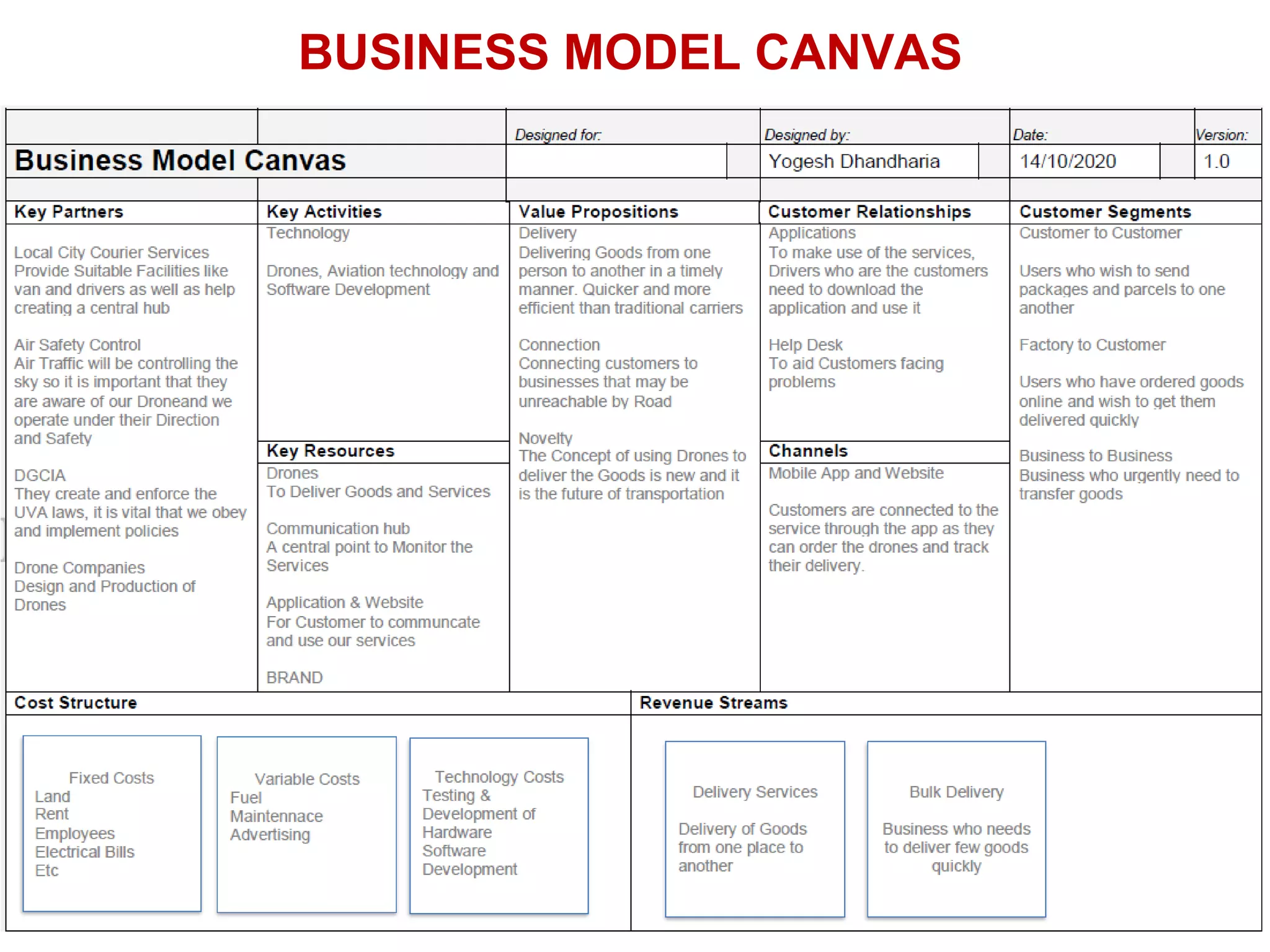
The document discusses the significance and applications of drones in e-commerce and goods delivery, highlighting trends, logistical challenges, and the projected growth of the drone delivery market. It outlines a proposed drone delivery system, including technical specifications and operational capabilities, while addressing regulatory considerations and operational procedures. Overall, it emphasizes the integration of technology and infrastructure to enhance efficiency in the delivery process.
7
Three Issues inLogistics Industry
• Inefficiency of Re-Delivery
Increase in the number of re-delivery
Decrease in labor productivity
Attempted delivery but absence
• Traffic Congestion
Heavy traffic due to increase in distribution
amount
Need extensive infrastructure
improvement to solve traffic problem
• Labor Shortage
Decrease in the number of truck drivers &
the aging of drivers
5.
World wide DroneDelivery Market Size
Set to Exceed $494.5 Million By 2026 | CAGR:32.7%
Source: www.polarismarketresearch.com
6.
Market in Indiafor Drone Based Solutions
Set to Exceed INR 6257 Crore By 2021 | CAGR:12.4%
Source: https://www.pwc.in/consulting/financial-services/fintech/fintech-insights/data-on-
wings-a-close-look-at-drones-in-india.html
7.
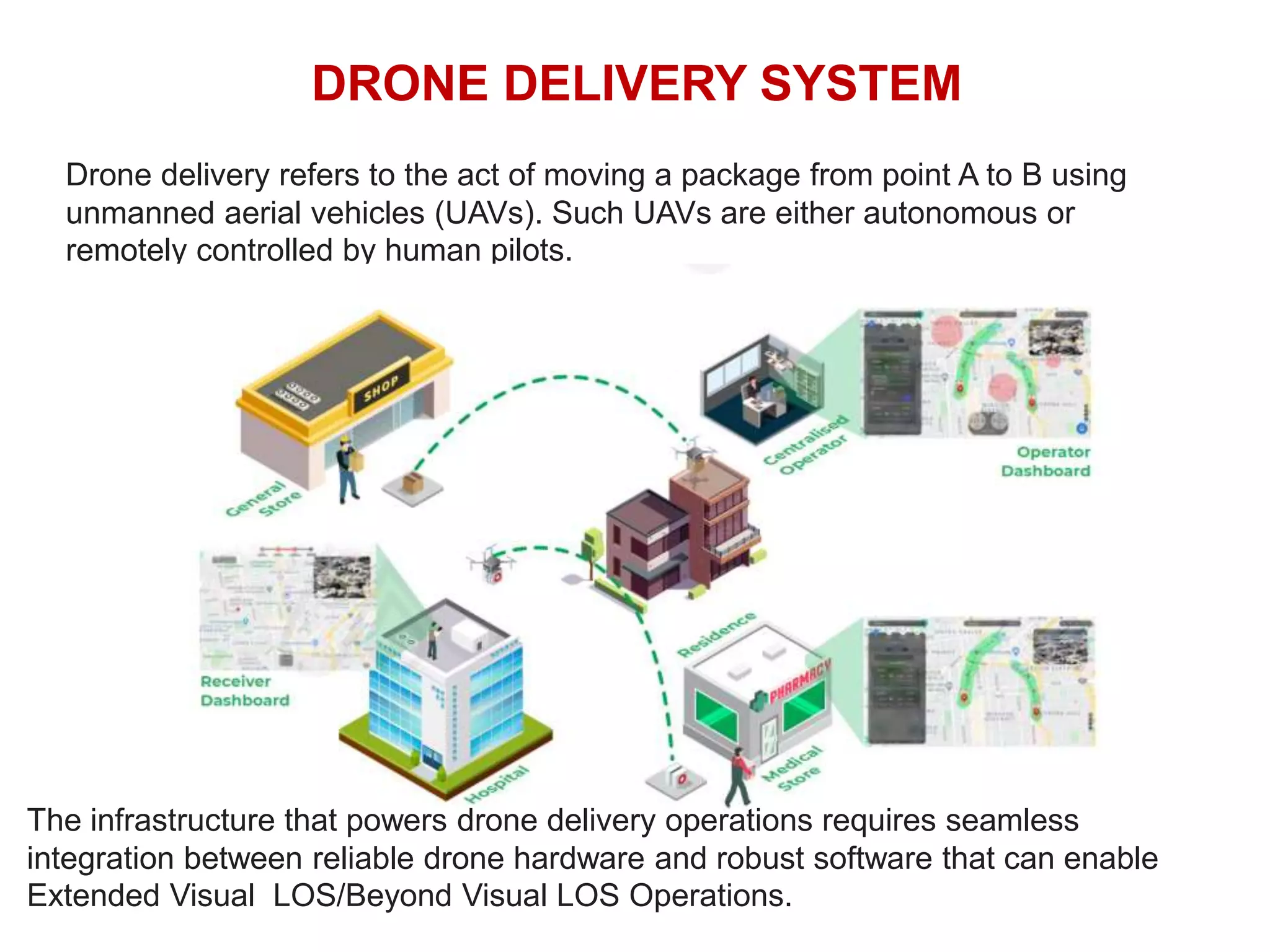
DRONE DELIVERY SYSTEM
Dronedelivery refers to the act of moving a package from point A to B using
unmanned aerial vehicles (UAVs). Such UAVs are either autonomous or
remotely controlled by human pilots.
The infrastructure that powers drone delivery operations requires seamless
integration between reliable drone hardware and robust software that can enable
Extended Visual LOS/Beyond Visual LOS Operations.
Proposed Prototype UseCase
The drone is operated during the usual delivery round from a vehicle specially
equipped with a mobile terminal. The mobile terminal lets deploy the drone take-off
and landing equipment directly from the delivery van’s roof.
During his round, if the driver has parcels for customers in our example location
Mahavir Nagar, he parks his vehicle in a dedicated parking space to safely perform
the following process:
•Activate the terminal’s deployment;
•Scan the parcel;
•Clip the parcel under the drone;
•Check to make sure that the area around
the van is clear;
•Request take-off authorization from the
operator;
•Wait for the drone to take off.
During the entire delivery mission, the
drone is on fully automatic flight mode,
under the remote supervision of an
operator certified by the DGCIA.
Technical Specifications
Drone technicalspecifications
•Operational capabilities:
Range: up to 15 km, or around 45min (depending on the wind)
Payload: up to 2 kg
Empty weight: 4 kg
Cruise speed: 30 km/h
•Technical specifications:
6 electric rotors
Carbon fibre chassis
Redundant embedded electronics
•Navigation system:
Embedded GPS and real-time trajectory tracking
Transmission range: up to 30 km
Ground station for programming and monitoring
14.
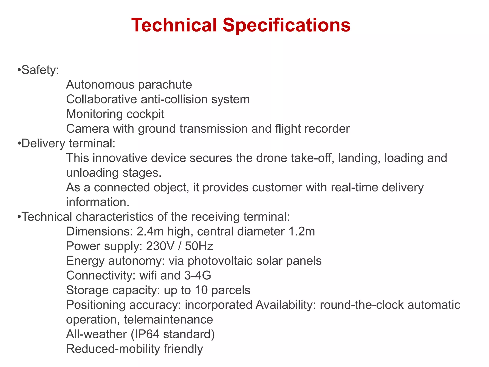
Technical Specifications
•Safety:
Autonomous parachute
Collaborativeanti-collision system
Monitoring cockpit
Camera with ground transmission and flight recorder
•Delivery terminal:
This innovative device secures the drone take-off, landing, loading and
unloading stages.
As a connected object, it provides customer with real-time delivery
information.
•Technical characteristics of the receiving terminal:
Dimensions: 2.4m high, central diameter 1.2m
Power supply: 230V / 50Hz
Energy autonomy: via photovoltaic solar panels
Connectivity: wifi and 3-4G
Storage capacity: up to 10 parcels
Positioning accuracy: incorporated Availability: round-the-clock automatic
operation, telemaintenance
All-weather (IP64 standard)
Reduced-mobility friendly
15.
Drone Regulation Enactedfrom 1 Dec. 2018
• Only allowed to fly with valid permit and UIN
• Only allowed to fly during daytime (Sunrise to Sunset)
• Fly within visible range, and always monitor drone and its surroundings
• Drone must keep 30 meter distance between third party person or buildings.
• Drones are not allowed to fly over 400 Feet vertically and restricted areas.
• Drone are not allowed to carry flammable items.
• Drones are not allowed to drop items from it while flying.
Rules for Way you Fly Permission from DGCIA is needed
A. Near airports C.DID area
B. Altitude
over 200 ft
Other then
A,B,C
Rules of Where you Fly Permission from DGCIA needed, for A,B,C