SlideShare a Scribd company logo
Archaeological Land Use Characterization using Multispectral Remote Sensing Data ,[object Object],[object Object],Monitoring Hidrological Variations using Multispectral SPOT-5 Data: Regional Case of Jalisco in Mexico Dr. Iván Esteban Villalón Turrubiates,  Member,   IEEE  UNIVERSIDAD DE GUADALAJARA CENTRO UNIVERSITARIO DE LOS VALLES
Overview ,[object Object],[object Object],[object Object],[object Object],[object Object],[object Object],[object Object],[object Object]
Abstract ,[object Object],[object Object],[object Object]
REMOTE SENSING DEFINITION
Remote Sensing ,[object Object],[object Object],[object Object]
 
Remote Sensing ,[object Object],[object Object],[object Object]
 
Remote Sensing ,[object Object],[object Object],[object Object]
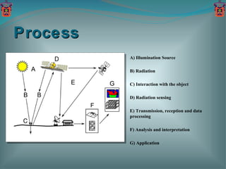
A) Illumination Source B) Radiation C) Interaction with the object D) Radiation sensing E) Transmission, reception and data processing F) Analysis and interpretation G) Application Process
SENSOR RESOLUTION
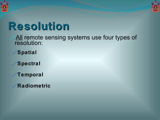
Resolution ,[object Object],[object Object],[object Object],[object Object],[object Object]
Spatial Resolution
Spectral Resolution
Temporal Resolution Time July 1 July 12 July 23 August 3 11 days 16 days July 2 July 8 August 3
Radiometric Resolution 6-bits Range 0 63 8-bits Range 0 255 0 10-bits Range 1023
INTRODUCTION TO IMAGE CLASSIFICATION
Image Classification ,[object Object],[object Object],[object Object],[object Object],[object Object],[object Object]
Typical uses ,[object Object],[object Object],[object Object],[object Object],[object Object],[object Object],[object Object],[object Object],[object Object],[object Object]
Example: Near Mary’s Peak ,[object Object],[object Object],Open Semi-open Broadleaf Mixed Young Conifer Mature Conifer Old Conifer Legend
Classification: Critical Point ,[object Object],[object Object],[object Object],[object Object],[object Object]
Basic Strategy: How to do it?  ,[object Object],[object Object]
[object Object],[object Object],[object Object],Basic Strategy: How to do it?
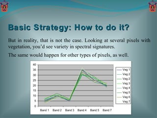
Basic Strategy: How to do it?  But in reality, that is not the case. Looking at several pixels with vegetation, you’d see variety in spectral signatures.  The same would happen for other types of pixels, as well.
The Classification Trick:  Deal with variability ,[object Object],[object Object]
Think of a pixel’s brightness in a 2-Dimensional space. The pixel occupies a point in that space. The vegetation pixel and the soil pixel occupy different points in a 2-D space.
With variability, the vegetation pixels now occupy a region, not a point, of n-Dimensional space. Soil pixels occupy a different region of  n-Dimensional space.
Basic Strategy:  Deal with variability ,[object Object],[object Object],[object Object]
Classification Strategies ,[object Object],[object Object],[object Object],[object Object],[object Object]
Supervised Classification The computer then creates... Supervised classification requires the analyst to select training areas where he knows what is on the ground and then digitize a polygon within that area… Mean  Spectral Signatures Known Conifer Area Known Water Area Known Deciduous Area Digital Image Conifer Deciduous Water
Supervised Classification Multispectral Image Information (Classified Image) Mean  Spectral Signatures Spectral Signature of Next Pixel to be Classified Conifer Deciduous Water Unknown
The Result: Image Signatures Water Conifer Deciduous Legend: Land Cover Map
Unsupervised Classification ,[object Object],[object Object],[object Object]
Unsupervised Classification Digital Image The analyst requests the computer to examine the image and extract a number of spectrally distinct clusters…  Spectrally Distinct Clusters Cluster 3 Cluster 5 Cluster 1 Cluster 6 Cluster 2 Cluster 4
Unsupervised Classification Output Classified Image Saved Clusters Cluster 3 Cluster 5 Cluster 1 Cluster 6 Cluster 2 Cluster 4 Unknown Next Pixel to be Classified
Unsupervised Classification It is a simple process to regroup (recode) the clusters into meaningful information classes (the legend). The result is essentially the same as that of the supervised classification: Conif. Hardw. Water Land Cover Map Legend Water Water Conifer Conifer Hardwood Hardwood Labels
MODEL FORMALISM
Multispectral Imaging ,[object Object],[object Object],[object Object],[object Object],[object Object],[object Object],[object Object]
[object Object],[object Object],[object Object],[object Object],[object Object],[object Object],Weighted Pixel Statistics Method
Blue Green Red Near-IR Mid-IR Mean Signature 1 Candidate Pixel Mean Signature 2 It appears that the candidate pixel is closest to Signature 1.  However, when we consider the variance around the signatures… Relative Reflectance Weighted Pixel Statistics Method
Blue Green Red Near-IR Mid-IR Mean Signature 1 Candidate Pixel Mean Signature 2 The candidate pixel clearly belongs to the signature 2 group. Relative Reflectance Weighted Pixel Statistics Method
Weighted Pixel Statistics Method
VERIFICATION PROTOCOLS
Verification Protocols ,[object Object],[object Object],[object Object],[object Object]
Results: 1 st  Synthesized Scene Synthesized Scene WOS Classification WPS Classification
Quantitative Comparison 1 st  Synthesized Scene
Results: 2 nd  Synthesized Scene Synthesized Scene WOS Classification WPS Classification
Qualitative Comparison 2 nd  Synthesized Scene Synthesized Scene WOS Classification WPS Classification
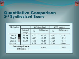
Quantitative Comparison 2 nd  Synthesized Scene
Results: 3 rd   Synthesized Scene Synthesized Scene WOS Classification WPS Classification
Qualitative Comparison 3 rd  Synthesized Scene Synthesized Scene WOS Classification WPS Classification
Quantitative Comparison 3 rd  Synthesized Scene
Remarks ,[object Object],[object Object],[object Object],[object Object]
SIMULATION EXPERIMENTS
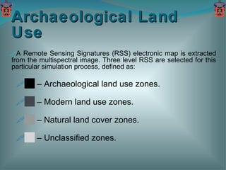
Archaeological Land Use ,[object Object],[object Object],[object Object],[object Object],[object Object]
Archaeological Site "Guachimontones", Jalisco Mexico
Simulation Results Scene from "Guachimontones" Original Scene WPS Classification
Hidrological Variations ,[object Object],[object Object],[object Object],[object Object],[object Object]
Simulation Results Scene from "La Vega" dam, Jalisco Mexico Original Scene WPS Classification
CONCLUDING REMARKS
Remarks ,[object Object],[object Object],[object Object]
Future Work ,[object Object],[object Object],[object Object],[object Object]
[object Object],UNIVERSIDAD DE GUADALAJARA CENTRO UNIVERSITARIO DE LOS VALLES THANK YOU! Questions?

More Related Content

What's hot

tesi_completa
tesi_completatesi_completa
tesi_completa
Federica Comini
 
Optical Remote sensing with case studies
Optical Remote sensing with case studiesOptical Remote sensing with case studies
Optical Remote sensing with case studies
SAISIKAN PATRA
 
Auto Level Color Correction f or Underwater Image Matching Optimization
Auto Level Color Correction f or Underwater Image Matching OptimizationAuto Level Color Correction f or Underwater Image Matching Optimization
Auto Level Color Correction f or Underwater Image Matching Optimization
Ricardus Anggi Pramunendar
 
Classification of Radar Returns from Ionosphere Using NB-Tree and CFS
Classification of Radar Returns from Ionosphere Using NB-Tree and CFSClassification of Radar Returns from Ionosphere Using NB-Tree and CFS
Classification of Radar Returns from Ionosphere Using NB-Tree and CFS
ijtsrd
 
PhysRevLett.105.163602
PhysRevLett.105.163602PhysRevLett.105.163602
PhysRevLett.105.163602
Fabrizio Guerrieri
 
Investigation of Chaotic-Type Features in Hyperspectral Satellite Data
Investigation of Chaotic-Type Features in Hyperspectral Satellite DataInvestigation of Chaotic-Type Features in Hyperspectral Satellite Data
Investigation of Chaotic-Type Features in Hyperspectral Satellite Data
csandit
 
An Efficient K-Nearest Neighbors Based Approach for Classifying Land Cover Re...
An Efficient K-Nearest Neighbors Based Approach for Classifying Land Cover Re...An Efficient K-Nearest Neighbors Based Approach for Classifying Land Cover Re...
An Efficient K-Nearest Neighbors Based Approach for Classifying Land Cover Re...
IDES Editor
 

What's hot (7)

tesi_completa
tesi_completatesi_completa
tesi_completa
 
Optical Remote sensing with case studies
Optical Remote sensing with case studiesOptical Remote sensing with case studies
Optical Remote sensing with case studies
 
Auto Level Color Correction f or Underwater Image Matching Optimization
Auto Level Color Correction f or Underwater Image Matching OptimizationAuto Level Color Correction f or Underwater Image Matching Optimization
Auto Level Color Correction f or Underwater Image Matching Optimization
 
Classification of Radar Returns from Ionosphere Using NB-Tree and CFS
Classification of Radar Returns from Ionosphere Using NB-Tree and CFSClassification of Radar Returns from Ionosphere Using NB-Tree and CFS
Classification of Radar Returns from Ionosphere Using NB-Tree and CFS
 
PhysRevLett.105.163602
PhysRevLett.105.163602PhysRevLett.105.163602
PhysRevLett.105.163602
 
Investigation of Chaotic-Type Features in Hyperspectral Satellite Data
Investigation of Chaotic-Type Features in Hyperspectral Satellite DataInvestigation of Chaotic-Type Features in Hyperspectral Satellite Data
Investigation of Chaotic-Type Features in Hyperspectral Satellite Data
 
An Efficient K-Nearest Neighbors Based Approach for Classifying Land Cover Re...
An Efficient K-Nearest Neighbors Based Approach for Classifying Land Cover Re...An Efficient K-Nearest Neighbors Based Approach for Classifying Land Cover Re...
An Efficient K-Nearest Neighbors Based Approach for Classifying Land Cover Re...
 

Viewers also liked

soil moisture retrieval.pptx
soil moisture retrieval.pptxsoil moisture retrieval.pptx
soil moisture retrieval.pptx
grssieee
 
1 IGARSS 2011 JPSS Monday Goldberg.pptx
1 IGARSS 2011 JPSS Monday Goldberg.pptx1 IGARSS 2011 JPSS Monday Goldberg.pptx
1 IGARSS 2011 JPSS Monday Goldberg.pptx
grssieee
 
OverviewofGCOM.pdf
OverviewofGCOM.pdfOverviewofGCOM.pdf
OverviewofGCOM.pdf
grssieee
 
IGARSS 2011.ppt
IGARSS 2011.pptIGARSS 2011.ppt
IGARSS 2011.ppt
grssieee
 
Grammar pre study
Grammar pre studyGrammar pre study
Grammar pre study
English Classroom
 
Model-based Polarimetric Decomposition using PolInSAR Coherence_v11(FILEminim...
Model-based Polarimetric Decomposition using PolInSAR Coherence_v11(FILEminim...Model-based Polarimetric Decomposition using PolInSAR Coherence_v11(FILEminim...
Model-based Polarimetric Decomposition using PolInSAR Coherence_v11(FILEminim...
grssieee
 
Igarss-Slides-2011-Fung.ppt
Igarss-Slides-2011-Fung.pptIgarss-Slides-2011-Fung.ppt
Igarss-Slides-2011-Fung.ppt
grssieee
 
Shkala
ShkalaShkala
ShkalaLungu
 
Tjuatja_IGARSS-11_prez.pptx
Tjuatja_IGARSS-11_prez.pptxTjuatja_IGARSS-11_prez.pptx
Tjuatja_IGARSS-11_prez.pptx
grssieee
 
WE1.L10 - GRACE Applications to Regional Hydrology and Water Resources
WE1.L10 - GRACE Applications to Regional Hydrology and Water ResourcesWE1.L10 - GRACE Applications to Regional Hydrology and Water Resources
WE1.L10 - GRACE Applications to Regional Hydrology and Water Resources
grssieee
 
simplex.pdf
simplex.pdfsimplex.pdf
simplex.pdf
grssieee
 
Fr1T101-Kuo-20110729 IGARSS ESC.pptx
Fr1T101-Kuo-20110729 IGARSS ESC.pptxFr1T101-Kuo-20110729 IGARSS ESC.pptx
Fr1T101-Kuo-20110729 IGARSS ESC.pptx
grssieee
 
WE1.L10 - INTERANNUAL VARIABILITY IN CLIMATE PRODUCTS FROM THE ATMOSPHERIC IN...
WE1.L10 - INTERANNUAL VARIABILITY IN CLIMATE PRODUCTS FROM THE ATMOSPHERIC IN...WE1.L10 - INTERANNUAL VARIABILITY IN CLIMATE PRODUCTS FROM THE ATMOSPHERIC IN...
WE1.L10 - INTERANNUAL VARIABILITY IN CLIMATE PRODUCTS FROM THE ATMOSPHERIC IN...
grssieee
 
POLAND OUR COUNTRY Comenius meeting XI 2011
POLAND OUR COUNTRY Comenius meeting XI 2011POLAND OUR COUNTRY Comenius meeting XI 2011
POLAND OUR COUNTRY Comenius meeting XI 2011
Bernadetta Utzig
 
Argumentative
ArgumentativeArgumentative
Argumentative
English Classroom
 
Metropolitan architects
Metropolitan architectsMetropolitan architects
Metropolitan architects
www.theurbanvision.com
 
Formont.ppt
Formont.pptFormont.ppt
Formont.ppt
grssieee
 
RoughSurfaceModels.ppt
RoughSurfaceModels.pptRoughSurfaceModels.ppt
RoughSurfaceModels.ppt
grssieee
 
TU1.T10.5.ppt
TU1.T10.5.pptTU1.T10.5.ppt
TU1.T10.5.ppt
grssieee
 
Cultural / Civic Entrepreneurs Forum: NSPA
 Cultural / Civic Entrepreneurs Forum: NSPA Cultural / Civic Entrepreneurs Forum: NSPA
Cultural / Civic Entrepreneurs Forum: NSPA
www.theurbanvision.com
 

Viewers also liked (20)

soil moisture retrieval.pptx
soil moisture retrieval.pptxsoil moisture retrieval.pptx
soil moisture retrieval.pptx
 
1 IGARSS 2011 JPSS Monday Goldberg.pptx
1 IGARSS 2011 JPSS Monday Goldberg.pptx1 IGARSS 2011 JPSS Monday Goldberg.pptx
1 IGARSS 2011 JPSS Monday Goldberg.pptx
 
OverviewofGCOM.pdf
OverviewofGCOM.pdfOverviewofGCOM.pdf
OverviewofGCOM.pdf
 
IGARSS 2011.ppt
IGARSS 2011.pptIGARSS 2011.ppt
IGARSS 2011.ppt
 
Grammar pre study
Grammar pre studyGrammar pre study
Grammar pre study
 
Model-based Polarimetric Decomposition using PolInSAR Coherence_v11(FILEminim...
Model-based Polarimetric Decomposition using PolInSAR Coherence_v11(FILEminim...Model-based Polarimetric Decomposition using PolInSAR Coherence_v11(FILEminim...
Model-based Polarimetric Decomposition using PolInSAR Coherence_v11(FILEminim...
 
Igarss-Slides-2011-Fung.ppt
Igarss-Slides-2011-Fung.pptIgarss-Slides-2011-Fung.ppt
Igarss-Slides-2011-Fung.ppt
 
Shkala
ShkalaShkala
Shkala
 
Tjuatja_IGARSS-11_prez.pptx
Tjuatja_IGARSS-11_prez.pptxTjuatja_IGARSS-11_prez.pptx
Tjuatja_IGARSS-11_prez.pptx
 
WE1.L10 - GRACE Applications to Regional Hydrology and Water Resources
WE1.L10 - GRACE Applications to Regional Hydrology and Water ResourcesWE1.L10 - GRACE Applications to Regional Hydrology and Water Resources
WE1.L10 - GRACE Applications to Regional Hydrology and Water Resources
 
simplex.pdf
simplex.pdfsimplex.pdf
simplex.pdf
 
Fr1T101-Kuo-20110729 IGARSS ESC.pptx
Fr1T101-Kuo-20110729 IGARSS ESC.pptxFr1T101-Kuo-20110729 IGARSS ESC.pptx
Fr1T101-Kuo-20110729 IGARSS ESC.pptx
 
WE1.L10 - INTERANNUAL VARIABILITY IN CLIMATE PRODUCTS FROM THE ATMOSPHERIC IN...
WE1.L10 - INTERANNUAL VARIABILITY IN CLIMATE PRODUCTS FROM THE ATMOSPHERIC IN...WE1.L10 - INTERANNUAL VARIABILITY IN CLIMATE PRODUCTS FROM THE ATMOSPHERIC IN...
WE1.L10 - INTERANNUAL VARIABILITY IN CLIMATE PRODUCTS FROM THE ATMOSPHERIC IN...
 
POLAND OUR COUNTRY Comenius meeting XI 2011
POLAND OUR COUNTRY Comenius meeting XI 2011POLAND OUR COUNTRY Comenius meeting XI 2011
POLAND OUR COUNTRY Comenius meeting XI 2011
 
Argumentative
ArgumentativeArgumentative
Argumentative
 
Metropolitan architects
Metropolitan architectsMetropolitan architects
Metropolitan architects
 
Formont.ppt
Formont.pptFormont.ppt
Formont.ppt
 
RoughSurfaceModels.ppt
RoughSurfaceModels.pptRoughSurfaceModels.ppt
RoughSurfaceModels.ppt
 
TU1.T10.5.ppt
TU1.T10.5.pptTU1.T10.5.ppt
TU1.T10.5.ppt
 
Cultural / Civic Entrepreneurs Forum: NSPA
 Cultural / Civic Entrepreneurs Forum: NSPA Cultural / Civic Entrepreneurs Forum: NSPA
Cultural / Civic Entrepreneurs Forum: NSPA
 

Similar to IGARSS 2011.ppt

Super-Resolution of Multispectral Images
Super-Resolution of Multispectral ImagesSuper-Resolution of Multispectral Images
Super-Resolution of Multispectral Images
ijsrd.com
 
Digital image classification22oct
Digital image classification22octDigital image classification22oct
Digital image classification22oct
Aleemuddin Abbasi
 
Object Classification of Satellite Images Using Cluster Repulsion Based Kerne...
Object Classification of Satellite Images Using Cluster Repulsion Based Kerne...Object Classification of Satellite Images Using Cluster Repulsion Based Kerne...
Object Classification of Satellite Images Using Cluster Repulsion Based Kerne...
IOSR Journals
 
Fd36957962
Fd36957962Fd36957962
Fd36957962
IJERA Editor
 
Digital_Image_Classification.pptx
Digital_Image_Classification.pptxDigital_Image_Classification.pptx
Digital_Image_Classification.pptx
BivaYadav3
 
Digital image processing
Digital image processingDigital image processing
Digital image processing
Vandana Verma
 
Comparison of Segmentation Algorithms and Estimation of Optimal Segmentation ...
Comparison of Segmentation Algorithms and Estimation of Optimal Segmentation ...Comparison of Segmentation Algorithms and Estimation of Optimal Segmentation ...
Comparison of Segmentation Algorithms and Estimation of Optimal Segmentation ...
Pinaki Ranjan Sarkar
 
Digital Image Classification.pptx
Digital Image Classification.pptxDigital Image Classification.pptx
Digital Image Classification.pptx
Hline Win
 
COLOUR IMAGE REPRESENTION OF MULTISPECTRAL IMAGE FUSION
COLOUR IMAGE REPRESENTION OF MULTISPECTRAL IMAGE FUSION COLOUR IMAGE REPRESENTION OF MULTISPECTRAL IMAGE FUSION
COLOUR IMAGE REPRESENTION OF MULTISPECTRAL IMAGE FUSION
acijjournal
 
COLOUR IMAGE REPRESENTION OF MULTISPECTRAL IMAGE FUSION
COLOUR IMAGE REPRESENTION OF MULTISPECTRAL IMAGE FUSIONCOLOUR IMAGE REPRESENTION OF MULTISPECTRAL IMAGE FUSION
COLOUR IMAGE REPRESENTION OF MULTISPECTRAL IMAGE FUSION
acijjournal
 
Satellite Image Classification using Decision Tree, SVM and k-Nearest Neighbor
Satellite Image Classification using Decision Tree, SVM and k-Nearest NeighborSatellite Image Classification using Decision Tree, SVM and k-Nearest Neighbor
Satellite Image Classification using Decision Tree, SVM and k-Nearest Neighbor
National Cheng Kung University
 
P.maria sheeba 15 mco010
P.maria sheeba 15 mco010P.maria sheeba 15 mco010
P.maria sheeba 15 mco010
W3Edify
 
Lw3620362041
Lw3620362041Lw3620362041
Lw3620362041
IJERA Editor
 
Detection of urban tree canopy from very high resolution imagery using an ob...
Detection of urban tree canopy from very high resolution  imagery using an ob...Detection of urban tree canopy from very high resolution  imagery using an ob...
Detection of urban tree canopy from very high resolution imagery using an ob...
IJECEIAES
 
IMAGE QUALITY OPTIMIZATION USING RSATV
IMAGE QUALITY OPTIMIZATION USING RSATVIMAGE QUALITY OPTIMIZATION USING RSATV
IMAGE QUALITY OPTIMIZATION USING RSATV
paperpublications3
 
Basics of remote sensing and GIS.pptx
Basics of remote sensing and GIS.pptxBasics of remote sensing and GIS.pptx
Basics of remote sensing and GIS.pptx
FUCKAGAIN
 
Mn3621372142
Mn3621372142Mn3621372142
Mn3621372142
IJERA Editor
 
CLASSIFICATION AND COMPARISION OF REMOTE SENSING IMAGE USING SUPPORT VECTOR M...
CLASSIFICATION AND COMPARISION OF REMOTE SENSING IMAGE USING SUPPORT VECTOR M...CLASSIFICATION AND COMPARISION OF REMOTE SENSING IMAGE USING SUPPORT VECTOR M...
CLASSIFICATION AND COMPARISION OF REMOTE SENSING IMAGE USING SUPPORT VECTOR M...
ADEIJ Journal
 
RADIOMETRIC RESOLUTION.pptx
RADIOMETRIC RESOLUTION.pptxRADIOMETRIC RESOLUTION.pptx
RADIOMETRIC RESOLUTION.pptx
Kuki Boruah
 
Shadow Detection and Removal Techniques A Perspective View
Shadow Detection and Removal Techniques A Perspective ViewShadow Detection and Removal Techniques A Perspective View
Shadow Detection and Removal Techniques A Perspective View
ijtsrd
 

Similar to IGARSS 2011.ppt (20)

Super-Resolution of Multispectral Images
Super-Resolution of Multispectral ImagesSuper-Resolution of Multispectral Images
Super-Resolution of Multispectral Images
 
Digital image classification22oct
Digital image classification22octDigital image classification22oct
Digital image classification22oct
 
Object Classification of Satellite Images Using Cluster Repulsion Based Kerne...
Object Classification of Satellite Images Using Cluster Repulsion Based Kerne...Object Classification of Satellite Images Using Cluster Repulsion Based Kerne...
Object Classification of Satellite Images Using Cluster Repulsion Based Kerne...
 
Fd36957962
Fd36957962Fd36957962
Fd36957962
 
Digital_Image_Classification.pptx
Digital_Image_Classification.pptxDigital_Image_Classification.pptx
Digital_Image_Classification.pptx
 
Digital image processing
Digital image processingDigital image processing
Digital image processing
 
Comparison of Segmentation Algorithms and Estimation of Optimal Segmentation ...
Comparison of Segmentation Algorithms and Estimation of Optimal Segmentation ...Comparison of Segmentation Algorithms and Estimation of Optimal Segmentation ...
Comparison of Segmentation Algorithms and Estimation of Optimal Segmentation ...
 
Digital Image Classification.pptx
Digital Image Classification.pptxDigital Image Classification.pptx
Digital Image Classification.pptx
 
COLOUR IMAGE REPRESENTION OF MULTISPECTRAL IMAGE FUSION
COLOUR IMAGE REPRESENTION OF MULTISPECTRAL IMAGE FUSION COLOUR IMAGE REPRESENTION OF MULTISPECTRAL IMAGE FUSION
COLOUR IMAGE REPRESENTION OF MULTISPECTRAL IMAGE FUSION
 
COLOUR IMAGE REPRESENTION OF MULTISPECTRAL IMAGE FUSION
COLOUR IMAGE REPRESENTION OF MULTISPECTRAL IMAGE FUSIONCOLOUR IMAGE REPRESENTION OF MULTISPECTRAL IMAGE FUSION
COLOUR IMAGE REPRESENTION OF MULTISPECTRAL IMAGE FUSION
 
Satellite Image Classification using Decision Tree, SVM and k-Nearest Neighbor
Satellite Image Classification using Decision Tree, SVM and k-Nearest NeighborSatellite Image Classification using Decision Tree, SVM and k-Nearest Neighbor
Satellite Image Classification using Decision Tree, SVM and k-Nearest Neighbor
 
P.maria sheeba 15 mco010
P.maria sheeba 15 mco010P.maria sheeba 15 mco010
P.maria sheeba 15 mco010
 
Lw3620362041
Lw3620362041Lw3620362041
Lw3620362041
 
Detection of urban tree canopy from very high resolution imagery using an ob...
Detection of urban tree canopy from very high resolution  imagery using an ob...Detection of urban tree canopy from very high resolution  imagery using an ob...
Detection of urban tree canopy from very high resolution imagery using an ob...
 
IMAGE QUALITY OPTIMIZATION USING RSATV
IMAGE QUALITY OPTIMIZATION USING RSATVIMAGE QUALITY OPTIMIZATION USING RSATV
IMAGE QUALITY OPTIMIZATION USING RSATV
 
Basics of remote sensing and GIS.pptx
Basics of remote sensing and GIS.pptxBasics of remote sensing and GIS.pptx
Basics of remote sensing and GIS.pptx
 
Mn3621372142
Mn3621372142Mn3621372142
Mn3621372142
 
CLASSIFICATION AND COMPARISION OF REMOTE SENSING IMAGE USING SUPPORT VECTOR M...
CLASSIFICATION AND COMPARISION OF REMOTE SENSING IMAGE USING SUPPORT VECTOR M...CLASSIFICATION AND COMPARISION OF REMOTE SENSING IMAGE USING SUPPORT VECTOR M...
CLASSIFICATION AND COMPARISION OF REMOTE SENSING IMAGE USING SUPPORT VECTOR M...
 
RADIOMETRIC RESOLUTION.pptx
RADIOMETRIC RESOLUTION.pptxRADIOMETRIC RESOLUTION.pptx
RADIOMETRIC RESOLUTION.pptx
 
Shadow Detection and Removal Techniques A Perspective View
Shadow Detection and Removal Techniques A Perspective ViewShadow Detection and Removal Techniques A Perspective View
Shadow Detection and Removal Techniques A Perspective View
 

More from grssieee

Tangent height accuracy of Superconducting Submillimeter-Wave Limb-Emission S...
Tangent height accuracy of Superconducting Submillimeter-Wave Limb-Emission S...Tangent height accuracy of Superconducting Submillimeter-Wave Limb-Emission S...
Tangent height accuracy of Superconducting Submillimeter-Wave Limb-Emission S...grssieee
 
SEGMENTATION OF POLARIMETRIC SAR DATA WITH A MULTI-TEXTURE PRODUCT MODEL
SEGMENTATION OF POLARIMETRIC SAR DATA WITH A MULTI-TEXTURE PRODUCT MODELSEGMENTATION OF POLARIMETRIC SAR DATA WITH A MULTI-TEXTURE PRODUCT MODEL
SEGMENTATION OF POLARIMETRIC SAR DATA WITH A MULTI-TEXTURE PRODUCT MODEL
grssieee
 
TWO-POINT STATISTIC OF POLARIMETRIC SAR DATA TWO-POINT STATISTIC OF POLARIMET...
TWO-POINT STATISTIC OF POLARIMETRIC SAR DATA TWO-POINT STATISTIC OF POLARIMET...TWO-POINT STATISTIC OF POLARIMETRIC SAR DATA TWO-POINT STATISTIC OF POLARIMET...
TWO-POINT STATISTIC OF POLARIMETRIC SAR DATA TWO-POINT STATISTIC OF POLARIMET...
grssieee
 
THE SENTINEL-1 MISSION AND ITS APPLICATION CAPABILITIES
THE SENTINEL-1 MISSION AND ITS APPLICATION CAPABILITIESTHE SENTINEL-1 MISSION AND ITS APPLICATION CAPABILITIES
THE SENTINEL-1 MISSION AND ITS APPLICATION CAPABILITIES
grssieee
 
GMES SPACE COMPONENT:PROGRAMMATIC STATUS
GMES SPACE COMPONENT:PROGRAMMATIC STATUSGMES SPACE COMPONENT:PROGRAMMATIC STATUS
GMES SPACE COMPONENT:PROGRAMMATIC STATUS
grssieee
 
PROGRESSES OF DEVELOPMENT OF CFOSAT SCATTEROMETER
PROGRESSES OF DEVELOPMENT OF CFOSAT SCATTEROMETERPROGRESSES OF DEVELOPMENT OF CFOSAT SCATTEROMETER
PROGRESSES OF DEVELOPMENT OF CFOSAT SCATTEROMETER
grssieee
 
DEVELOPMENT OF ALGORITHMS AND PRODUCTS FOR SUPPORTING THE ITALIAN HYPERSPECTR...
DEVELOPMENT OF ALGORITHMS AND PRODUCTS FOR SUPPORTING THE ITALIAN HYPERSPECTR...DEVELOPMENT OF ALGORITHMS AND PRODUCTS FOR SUPPORTING THE ITALIAN HYPERSPECTR...
DEVELOPMENT OF ALGORITHMS AND PRODUCTS FOR SUPPORTING THE ITALIAN HYPERSPECTR...
grssieee
 
EO-1/HYPERION: NEARING TWELVE YEARS OF SUCCESSFUL MISSION SCIENCE OPERATION A...
EO-1/HYPERION: NEARING TWELVE YEARS OF SUCCESSFUL MISSION SCIENCE OPERATION A...EO-1/HYPERION: NEARING TWELVE YEARS OF SUCCESSFUL MISSION SCIENCE OPERATION A...
EO-1/HYPERION: NEARING TWELVE YEARS OF SUCCESSFUL MISSION SCIENCE OPERATION A...
grssieee
 
Test
TestTest
Test
grssieee
 
test 34mb wo animations
test  34mb wo animationstest  34mb wo animations
test 34mb wo animationsgrssieee
 
2011_Fox_Tax_Worksheets.pdf
2011_Fox_Tax_Worksheets.pdf2011_Fox_Tax_Worksheets.pdf
2011_Fox_Tax_Worksheets.pdf
grssieee
 
DLR open house
DLR open houseDLR open house
DLR open housegrssieee
 
DLR open house
DLR open houseDLR open house
DLR open housegrssieee
 
DLR open house
DLR open houseDLR open house
DLR open housegrssieee
 
Tana_IGARSS2011.ppt
Tana_IGARSS2011.pptTana_IGARSS2011.ppt
Tana_IGARSS2011.ppt
grssieee
 
Solaro_IGARSS_2011.ppt
Solaro_IGARSS_2011.pptSolaro_IGARSS_2011.ppt
Solaro_IGARSS_2011.ppt
grssieee
 

More from grssieee (20)

Tangent height accuracy of Superconducting Submillimeter-Wave Limb-Emission S...
Tangent height accuracy of Superconducting Submillimeter-Wave Limb-Emission S...Tangent height accuracy of Superconducting Submillimeter-Wave Limb-Emission S...
Tangent height accuracy of Superconducting Submillimeter-Wave Limb-Emission S...
 
SEGMENTATION OF POLARIMETRIC SAR DATA WITH A MULTI-TEXTURE PRODUCT MODEL
SEGMENTATION OF POLARIMETRIC SAR DATA WITH A MULTI-TEXTURE PRODUCT MODELSEGMENTATION OF POLARIMETRIC SAR DATA WITH A MULTI-TEXTURE PRODUCT MODEL
SEGMENTATION OF POLARIMETRIC SAR DATA WITH A MULTI-TEXTURE PRODUCT MODEL
 
TWO-POINT STATISTIC OF POLARIMETRIC SAR DATA TWO-POINT STATISTIC OF POLARIMET...
TWO-POINT STATISTIC OF POLARIMETRIC SAR DATA TWO-POINT STATISTIC OF POLARIMET...TWO-POINT STATISTIC OF POLARIMETRIC SAR DATA TWO-POINT STATISTIC OF POLARIMET...
TWO-POINT STATISTIC OF POLARIMETRIC SAR DATA TWO-POINT STATISTIC OF POLARIMET...
 
THE SENTINEL-1 MISSION AND ITS APPLICATION CAPABILITIES
THE SENTINEL-1 MISSION AND ITS APPLICATION CAPABILITIESTHE SENTINEL-1 MISSION AND ITS APPLICATION CAPABILITIES
THE SENTINEL-1 MISSION AND ITS APPLICATION CAPABILITIES
 
GMES SPACE COMPONENT:PROGRAMMATIC STATUS
GMES SPACE COMPONENT:PROGRAMMATIC STATUSGMES SPACE COMPONENT:PROGRAMMATIC STATUS
GMES SPACE COMPONENT:PROGRAMMATIC STATUS
 
PROGRESSES OF DEVELOPMENT OF CFOSAT SCATTEROMETER
PROGRESSES OF DEVELOPMENT OF CFOSAT SCATTEROMETERPROGRESSES OF DEVELOPMENT OF CFOSAT SCATTEROMETER
PROGRESSES OF DEVELOPMENT OF CFOSAT SCATTEROMETER
 
DEVELOPMENT OF ALGORITHMS AND PRODUCTS FOR SUPPORTING THE ITALIAN HYPERSPECTR...
DEVELOPMENT OF ALGORITHMS AND PRODUCTS FOR SUPPORTING THE ITALIAN HYPERSPECTR...DEVELOPMENT OF ALGORITHMS AND PRODUCTS FOR SUPPORTING THE ITALIAN HYPERSPECTR...
DEVELOPMENT OF ALGORITHMS AND PRODUCTS FOR SUPPORTING THE ITALIAN HYPERSPECTR...
 
EO-1/HYPERION: NEARING TWELVE YEARS OF SUCCESSFUL MISSION SCIENCE OPERATION A...
EO-1/HYPERION: NEARING TWELVE YEARS OF SUCCESSFUL MISSION SCIENCE OPERATION A...EO-1/HYPERION: NEARING TWELVE YEARS OF SUCCESSFUL MISSION SCIENCE OPERATION A...
EO-1/HYPERION: NEARING TWELVE YEARS OF SUCCESSFUL MISSION SCIENCE OPERATION A...
 
EO-1/HYPERION: NEARING TWELVE YEARS OF SUCCESSFUL MISSION SCIENCE OPERATION A...
EO-1/HYPERION: NEARING TWELVE YEARS OF SUCCESSFUL MISSION SCIENCE OPERATION A...EO-1/HYPERION: NEARING TWELVE YEARS OF SUCCESSFUL MISSION SCIENCE OPERATION A...
EO-1/HYPERION: NEARING TWELVE YEARS OF SUCCESSFUL MISSION SCIENCE OPERATION A...
 
Test
TestTest
Test
 
test 34mb wo animations
test  34mb wo animationstest  34mb wo animations
test 34mb wo animations
 
Test 70MB
Test 70MBTest 70MB
Test 70MB
 
Test 70MB
Test 70MBTest 70MB
Test 70MB
 
2011_Fox_Tax_Worksheets.pdf
2011_Fox_Tax_Worksheets.pdf2011_Fox_Tax_Worksheets.pdf
2011_Fox_Tax_Worksheets.pdf
 
DLR open house
DLR open houseDLR open house
DLR open house
 
DLR open house
DLR open houseDLR open house
DLR open house
 
DLR open house
DLR open houseDLR open house
DLR open house
 
Tana_IGARSS2011.ppt
Tana_IGARSS2011.pptTana_IGARSS2011.ppt
Tana_IGARSS2011.ppt
 
Solaro_IGARSS_2011.ppt
Solaro_IGARSS_2011.pptSolaro_IGARSS_2011.ppt
Solaro_IGARSS_2011.ppt
 

Recently uploaded

HCL Notes and Domino License Cost Reduction in the World of DLAU
HCL Notes and Domino License Cost Reduction in the World of DLAUHCL Notes and Domino License Cost Reduction in the World of DLAU
HCL Notes and Domino License Cost Reduction in the World of DLAU
panagenda
 
AI 101: An Introduction to the Basics and Impact of Artificial Intelligence
AI 101: An Introduction to the Basics and Impact of Artificial IntelligenceAI 101: An Introduction to the Basics and Impact of Artificial Intelligence
AI 101: An Introduction to the Basics and Impact of Artificial Intelligence
IndexBug
 
Video Streaming: Then, Now, and in the Future
Video Streaming: Then, Now, and in the FutureVideo Streaming: Then, Now, and in the Future
Video Streaming: Then, Now, and in the Future
Alpen-Adria-Universität
 
UiPath Test Automation using UiPath Test Suite series, part 5
UiPath Test Automation using UiPath Test Suite series, part 5UiPath Test Automation using UiPath Test Suite series, part 5
UiPath Test Automation using UiPath Test Suite series, part 5
DianaGray10
 
Full-RAG: A modern architecture for hyper-personalization
Full-RAG: A modern architecture for hyper-personalizationFull-RAG: A modern architecture for hyper-personalization
Full-RAG: A modern architecture for hyper-personalization
Zilliz
 
Unlock the Future of Search with MongoDB Atlas_ Vector Search Unleashed.pdf
Unlock the Future of Search with MongoDB Atlas_ Vector Search Unleashed.pdfUnlock the Future of Search with MongoDB Atlas_ Vector Search Unleashed.pdf
Unlock the Future of Search with MongoDB Atlas_ Vector Search Unleashed.pdf
Malak Abu Hammad
 
Observability Concepts EVERY Developer Should Know -- DeveloperWeek Europe.pdf
Observability Concepts EVERY Developer Should Know -- DeveloperWeek Europe.pdfObservability Concepts EVERY Developer Should Know -- DeveloperWeek Europe.pdf
Observability Concepts EVERY Developer Should Know -- DeveloperWeek Europe.pdf
Paige Cruz
 
Mind map of terminologies used in context of Generative AI
Mind map of terminologies used in context of Generative AIMind map of terminologies used in context of Generative AI
Mind map of terminologies used in context of Generative AI
Kumud Singh
 
Artificial Intelligence for XMLDevelopment
Artificial Intelligence for XMLDevelopmentArtificial Intelligence for XMLDevelopment
Artificial Intelligence for XMLDevelopment
Octavian Nadolu
 
Cosa hanno in comune un mattoncino Lego e la backdoor XZ?
Cosa hanno in comune un mattoncino Lego e la backdoor XZ?Cosa hanno in comune un mattoncino Lego e la backdoor XZ?
Cosa hanno in comune un mattoncino Lego e la backdoor XZ?
Speck&Tech
 
HCL Notes und Domino Lizenzkostenreduzierung in der Welt von DLAU
HCL Notes und Domino Lizenzkostenreduzierung in der Welt von DLAUHCL Notes und Domino Lizenzkostenreduzierung in der Welt von DLAU
HCL Notes und Domino Lizenzkostenreduzierung in der Welt von DLAU
panagenda
 
Best 20 SEO Techniques To Improve Website Visibility In SERP
Best 20 SEO Techniques To Improve Website Visibility In SERPBest 20 SEO Techniques To Improve Website Visibility In SERP
Best 20 SEO Techniques To Improve Website Visibility In SERP
Pixlogix Infotech
 
Introduction to CHERI technology - Cybersecurity
Introduction to CHERI technology - CybersecurityIntroduction to CHERI technology - Cybersecurity
Introduction to CHERI technology - Cybersecurity
mikeeftimakis1
 
GraphSummit Singapore | The Art of the Possible with Graph - Q2 2024
GraphSummit Singapore | The Art of the  Possible with Graph - Q2 2024GraphSummit Singapore | The Art of the  Possible with Graph - Q2 2024
GraphSummit Singapore | The Art of the Possible with Graph - Q2 2024
Neo4j
 
Programming Foundation Models with DSPy - Meetup Slides
Programming Foundation Models with DSPy - Meetup SlidesProgramming Foundation Models with DSPy - Meetup Slides
Programming Foundation Models with DSPy - Meetup Slides
Zilliz
 
Presentation of the OECD Artificial Intelligence Review of Germany
Presentation of the OECD Artificial Intelligence Review of GermanyPresentation of the OECD Artificial Intelligence Review of Germany
Presentation of the OECD Artificial Intelligence Review of Germany
innovationoecd
 
TrustArc Webinar - 2024 Global Privacy Survey
TrustArc Webinar - 2024 Global Privacy SurveyTrustArc Webinar - 2024 Global Privacy Survey
TrustArc Webinar - 2024 Global Privacy Survey
TrustArc
 
Climate Impact of Software Testing at Nordic Testing Days
Climate Impact of Software Testing at Nordic Testing DaysClimate Impact of Software Testing at Nordic Testing Days
Climate Impact of Software Testing at Nordic Testing Days
Kari Kakkonen
 
National Security Agency - NSA mobile device best practices
National Security Agency - NSA mobile device best practicesNational Security Agency - NSA mobile device best practices
National Security Agency - NSA mobile device best practices
Quotidiano Piemontese
 
RESUME BUILDER APPLICATION Project for students
RESUME BUILDER APPLICATION Project for studentsRESUME BUILDER APPLICATION Project for students
RESUME BUILDER APPLICATION Project for students
KAMESHS29
 

Recently uploaded (20)

HCL Notes and Domino License Cost Reduction in the World of DLAU
HCL Notes and Domino License Cost Reduction in the World of DLAUHCL Notes and Domino License Cost Reduction in the World of DLAU
HCL Notes and Domino License Cost Reduction in the World of DLAU
 
AI 101: An Introduction to the Basics and Impact of Artificial Intelligence
AI 101: An Introduction to the Basics and Impact of Artificial IntelligenceAI 101: An Introduction to the Basics and Impact of Artificial Intelligence
AI 101: An Introduction to the Basics and Impact of Artificial Intelligence
 
Video Streaming: Then, Now, and in the Future
Video Streaming: Then, Now, and in the FutureVideo Streaming: Then, Now, and in the Future
Video Streaming: Then, Now, and in the Future
 
UiPath Test Automation using UiPath Test Suite series, part 5
UiPath Test Automation using UiPath Test Suite series, part 5UiPath Test Automation using UiPath Test Suite series, part 5
UiPath Test Automation using UiPath Test Suite series, part 5
 
Full-RAG: A modern architecture for hyper-personalization
Full-RAG: A modern architecture for hyper-personalizationFull-RAG: A modern architecture for hyper-personalization
Full-RAG: A modern architecture for hyper-personalization
 
Unlock the Future of Search with MongoDB Atlas_ Vector Search Unleashed.pdf
Unlock the Future of Search with MongoDB Atlas_ Vector Search Unleashed.pdfUnlock the Future of Search with MongoDB Atlas_ Vector Search Unleashed.pdf
Unlock the Future of Search with MongoDB Atlas_ Vector Search Unleashed.pdf
 
Observability Concepts EVERY Developer Should Know -- DeveloperWeek Europe.pdf
Observability Concepts EVERY Developer Should Know -- DeveloperWeek Europe.pdfObservability Concepts EVERY Developer Should Know -- DeveloperWeek Europe.pdf
Observability Concepts EVERY Developer Should Know -- DeveloperWeek Europe.pdf
 
Mind map of terminologies used in context of Generative AI
Mind map of terminologies used in context of Generative AIMind map of terminologies used in context of Generative AI
Mind map of terminologies used in context of Generative AI
 
Artificial Intelligence for XMLDevelopment
Artificial Intelligence for XMLDevelopmentArtificial Intelligence for XMLDevelopment
Artificial Intelligence for XMLDevelopment
 
Cosa hanno in comune un mattoncino Lego e la backdoor XZ?
Cosa hanno in comune un mattoncino Lego e la backdoor XZ?Cosa hanno in comune un mattoncino Lego e la backdoor XZ?
Cosa hanno in comune un mattoncino Lego e la backdoor XZ?
 
HCL Notes und Domino Lizenzkostenreduzierung in der Welt von DLAU
HCL Notes und Domino Lizenzkostenreduzierung in der Welt von DLAUHCL Notes und Domino Lizenzkostenreduzierung in der Welt von DLAU
HCL Notes und Domino Lizenzkostenreduzierung in der Welt von DLAU
 
Best 20 SEO Techniques To Improve Website Visibility In SERP
Best 20 SEO Techniques To Improve Website Visibility In SERPBest 20 SEO Techniques To Improve Website Visibility In SERP
Best 20 SEO Techniques To Improve Website Visibility In SERP
 
Introduction to CHERI technology - Cybersecurity
Introduction to CHERI technology - CybersecurityIntroduction to CHERI technology - Cybersecurity
Introduction to CHERI technology - Cybersecurity
 
GraphSummit Singapore | The Art of the Possible with Graph - Q2 2024
GraphSummit Singapore | The Art of the  Possible with Graph - Q2 2024GraphSummit Singapore | The Art of the  Possible with Graph - Q2 2024
GraphSummit Singapore | The Art of the Possible with Graph - Q2 2024
 
Programming Foundation Models with DSPy - Meetup Slides
Programming Foundation Models with DSPy - Meetup SlidesProgramming Foundation Models with DSPy - Meetup Slides
Programming Foundation Models with DSPy - Meetup Slides
 
Presentation of the OECD Artificial Intelligence Review of Germany
Presentation of the OECD Artificial Intelligence Review of GermanyPresentation of the OECD Artificial Intelligence Review of Germany
Presentation of the OECD Artificial Intelligence Review of Germany
 
TrustArc Webinar - 2024 Global Privacy Survey
TrustArc Webinar - 2024 Global Privacy SurveyTrustArc Webinar - 2024 Global Privacy Survey
TrustArc Webinar - 2024 Global Privacy Survey
 
Climate Impact of Software Testing at Nordic Testing Days
Climate Impact of Software Testing at Nordic Testing DaysClimate Impact of Software Testing at Nordic Testing Days
Climate Impact of Software Testing at Nordic Testing Days
 
National Security Agency - NSA mobile device best practices
National Security Agency - NSA mobile device best practicesNational Security Agency - NSA mobile device best practices
National Security Agency - NSA mobile device best practices
 
RESUME BUILDER APPLICATION Project for students
RESUME BUILDER APPLICATION Project for studentsRESUME BUILDER APPLICATION Project for students
RESUME BUILDER APPLICATION Project for students
 

IGARSS 2011.ppt

Editor's Notes

  1. Information usually gathered from spacecraft or an airplane, but can be a handheld or boom-mounted device. Originally defined in 1960’s according to Jensen, to encompass photogrammertry and information gathered from nonphotometric sources.